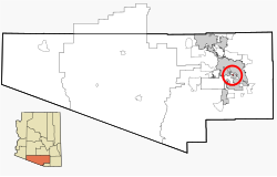
Littletown, Arizona | |
---|---|
Former CDP | |
Coordinates: 32°7′56″N110°52′37″W / 32.13222°N 110.87694°W | |
Country | United States |
State | Arizona |
County | Pima |
Area | |
• Total | 0.13 sq mi (0.32 km2) |
• Land | 0.13 sq mi (0.32 km2) |
• Water | 0.00 sq mi (0.00 km2) |
Elevation | 2,717 ft (828 m) |
Population (2010) | |
• Total | 5,476 |
• Estimate (2016) [2] | N/A |
Time zone | UTC-7 (MST (no DST)) |
FIPS code | 04-41540 |
GNIS feature ID | 7239 |
Littletown was a census-designated place (CDP) in Pima County, Arizona, United States. The population was 1,010 at the 2000 census. The area was annexed into Tucson in 2017. [3]
Littletown is located at 32°7′56″N110°52′37″W / 32.13222°N 110.87694°W (32.132144, -110.877003). [4]
According to the Federal Bureau of the Census, the CDP has a total area of 0.4 square miles (1.0 km2), all land.
Littletown is located on Interstate 10, southeast of Drexel-Alvernon. It was mostly surrounded by Tucson until it became part of the city.
Census | Pop. | Note | %± |
---|---|---|---|
2000 | 1,010 | — | |
2010 | 5,476 | 442.2% | |
U.S. Decennial Census [5] |
At the 2000 census there were 1,010 people, 313 households, and 244 families living in the CDP. The population density was 2,230.8 inhabitants per square mile (861.3/km2). There were 329 housing units at an average density of 726.7/sq mi (280.6/km2). The racial makeup of the CDP was 64.1% White, 2.1% Black or African American, 2.7% Native American, 0.2% Asian, 24.9% from other races, and 6.1% from two or more races. 50.4% of the population were Hispanic or Latino of any race. [6] Of the 313 households 41.2% had children under the age of 18 living with them, 55.0% were married couples living together, 16.0% had a female householder with no husband present, and 22.0% were non-families. 17.3% of households were one person and 4.2% were one person aged 65 or older. The average household size was 3.23 and the average family size was 3.66.
The age distribution was 33.6% under the age of 18, 10.7% from 18 to 24, 26.5% from 25 to 44, 22.8% from 45 to 64, and 6.4% 65 or older. The median age was 30 years. For every 100 females, there were 96.1 males. For every 100 females age 18 and over, there were 92.3 males.
The median household income was $35,833 and the median family income was $35,046. Males had a median income of $26,394 versus $17,396 for females. The per capita income for the CDP was $8,892. About 7.7% of families and 9.7% of the population were below the poverty line, including 7.5% of those under age 18 and 65.2% of those age 65 or over.
The former CDP is served by Craycroft Elementary School, Billy Lane Laufer Middle School, and Desert View High School, all part of the Sunnyside Unified School District.
Tonalea is a census-designated place (CDP) in Coconino County, Arizona, United States. The population was 549 at the 2010 census. It has also been known as Red Lake.
Claypool is a census-designated place (CDP) in Gila County, Arizona, United States. The population was 1,538 at the 2010 census, down from 1,794 at the 2000 census. It was named after W. D. Claypool, a member of both the State House of Representatives and State Senate in the 1910s and 1920s.
Catalina is a census-designated place (CDP) in Pima County, Arizona, United States. The population was 7,025 at the 2000 census. Catalina continues to experience increasing population growth, while attempting to maintain its rural character. Catalina remains an unincorporated community, with no plans for annexation into any nearby towns.
Corona de Tucson is a census-designated place (CDP) in Pima County, Arizona, United States. The population was 9,240 at the 2020 census, an increase of 1036% from the 2000 population of 813.
East Sahuarita was a census-designated place (CDP) in Pima County, Arizona, United States. The population was 1,419 at the 2000 census. The CDP comprises the unincorporated neighborhoods east of incorporated Sahuarita.
Picture Rocks is a census-designated place (CDP) in Pima County, Arizona, United States, home of the Tucson artifacts. The population was 9,551 at the 2020 United States census.
Three Points is a census-designated place (CDP) in Pima County, Arizona, United States. The population was 5,581 at the 2010 census.
Tucson Estates is a census-designated place (CDP) in Pima County, Arizona, United States. The population was 9,755 at the 2000 census.
Vail is a census-designated place (CDP) in Pima County, Arizona, United States. It is 24 miles (39 km) southeast of Tucson. The population was 10,208 at the 2010 census, up from 2484 in the 2000 census. The area is known for the nearby Colossal Cave, a large cave system, and the Rincon Mountains District of Saguaro National Park, a top tourism spot within Arizona.
Dudleyville is a census-designated place (CDP) in Pinal County, Arizona, United States. The population was 959 at the 2010 census.
Tahoe Vista is a census-designated place located on the north shore of Lake Tahoe in Placer County, California. It is part of the Sacramento–Arden-Arcade–Roseville Metropolitan Statistical Area. The population was 1,433 at the 2010 census, down from 1,668 at the 2000 census.
Earlimart is an unincorporated community in Tulare County, California, United States. At the 2010 census, the CDP population was 8,537, up from 6,583 at the 2000 census. For statistical purposes, the Census Bureau defines Earlimart as a census-designated place (CDP).
Eastpoint is a census-designated place (CDP) in Franklin County, Florida, United States. The population was 2,337 at the 2010 census.
South Gate was a census-designated place (CDP) in Anne Arundel County, Maryland, United States, for the 2000 census, at which time its population was 28,672. It was added primarily to the Glen Burnie CDP for the 2010 census.
Potomac Heights is a census-designated place (CDP) in Charles County, Maryland, United States. The population was 1,117 at the 2010 census. It has a volunteer fire department and numerous older rambler homes built for workers at the nearby U.S. Navy munitions plant in Indian Head.
Littleton Common is a census-designated place (CDP) in the town of Littleton in Middlesex County, Massachusetts, United States. The population was 3,065 at the 2020 census, up from 2,789 in 2010.
Iola is a census-designated place in Columbia County, Pennsylvania, United States. It is part of Northeastern Pennsylvania. The population was 154 at the 2020 census. It is part of the Bloomsburg-Berwick micropolitan area.
Eastlawn Gardens is a census-designated place (CDP) in Upper Nazareth Township in Northampton County, Pennsylvania. The population of Eastlawn Gardens was 3,307 at the 2010 census. Eastlawn Gardens is part of the Lehigh Valley metropolitan area, which had a population of 861,899 and was the 68th-most populous metropolitan area in the U.S. as of the 2020 census.
Wakefield-Peacedale is a census-designated place (CDP) in the town of South Kingstown in Washington County, Rhode Island, United States that includes the villages of Peace Dale and Wakefield. The population was 8,487 at the 2010 census.
Greenville is a census-designated place (CDP) in the town of Greenville in Piscataquis County, Maine, United States. The population was 1,010 at the 2020 census.