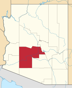
St. Johns, Maricopa County, Arizona

Last updated

St. Johns, Arizona
Maricopa County Arizona Incorporated and Unincorporated areas St. Johns Highlighted 0462362.svg
Location in Maricopa County, Arizona
USA Arizona location map.svg
Red pog.svg
St. Johns
Usa edcp location map.svg
Red pog.svg
St. Johns
Coordinates: 33°18′16″N112°11′41″W / 33.30444°N 112.19472°W / 33.30444; -112.19472
Country United States
State Arizona
County Maricopa
Area
[1]
  Total2.28 sq mi (5.9 km2)
  Land2.28 sq mi (5.9 km2)
  Water0.0 sq mi (0 km2)
Elevation
[2]
1,011 ft (308 m)
Population
 (2020) [3]
  Total690
  Density302.5/sq mi (116.8/km2)
Time zone UTC-7 (MST (no DST))
ZIP code
85339 (Laveen)
FIPS code 04-62362
GNIS feature ID 2612144 [2]

St. Johns is a census-designated place (CDP) in Maricopa County, Arizona, United States, located in the Gila River Indian Community. The population was 690 at the 2020 census, [3] up from 476 at the 2010 census.

Contents

Geography

St. Johns is on the south side of the Phoenix metropolitan area, on the northeast side of the valley of the Gila River. It is bordered to the southeast by the communities of Komatke and Gila Crossing. Downtown Phoenix is 15 miles (24 km) to the northeast.

Demographics

As of the census [4] of 2010, there were 476 people living in the CDP. The population density was 208.7 people per square mile. The racial makeup of the CDP was 3% White, <1% Black or African American, 95% Native American, 1% from other races, and 1% from two or more races. 4% of the population were Hispanic or Latino of any race.

Notes

  1. "2021 U.S. Gazetteer Files: Arizona". United States Census Bureau. Retrieved May 17, 2022.
  2. 1 2 U.S. Geological Survey Geographic Names Information System: St. Johns, Maricopa County, Arizona
  3. 1 2 "St. Johns CDP, Arizona: 2020 DEC Redistricting Data (PL 94-171)". U.S. Census Bureau. Retrieved May 17, 2022.
  4. United States Census [ dead link ]


Related Research Articles

<span class="mw-page-title-main">Gila County, Arizona</span> County in Arizona, United States

Gila County is a county in the central part of the U.S. state of Arizona. As of the 2020 census, the population was 53,272. The county seat is Globe.

<span class="mw-page-title-main">Maricopa County, Arizona</span> County in Arizona, United States

Maricopa County is a county in the south-central part of the U.S. state of Arizona. As of the 2020 census the population was 4,420,568, or about 62% of the state's total, making it the fourth-most populous county in the United States and the most populous county in Arizona, and making Arizona one of the nation's most centralized states. The county seat is Phoenix, the state capital and fifth-most populous city in the United States.

<span class="mw-page-title-main">Pinal County, Arizona</span> County in Arizona, United States

Pinal County is a county in the central part of the U.S. state of Arizona. According to the 2020 census, the population of the county was 425,264, making it Arizona's third-most populous county. The county seat is Florence. The county was founded in 1875.

<span class="mw-page-title-main">Strawberry, Arizona</span> CDP in Gila County, Arizona

Strawberry is an unincorporated community and census-designated place (CDP) in Gila County, Arizona, United States. The population was 961 at the 2010 census.

<span class="mw-page-title-main">New River, Arizona</span> CDP in Maricopa County, Arizona

New River is an unincorporated community and census-designated place (CDP) in Maricopa County, Arizona, United States. The population was 17,290 as of the 2020 census, up from 14,952 at the 2010 census.

<span class="mw-page-title-main">Rio Verde, Arizona</span> CDP in Maricopa County, Arizona

Rio Verde is a master-planned community just east of Scottsdale, in Arizona. It is also a census-designated place (CDP) in Maricopa County, Arizona, United States, located in the far, far northeast area of the whole Phoenix Metropolitan Area. The population was 2,210 as of the 2020 census, up from 1,811 at the 2010 census.

<span class="mw-page-title-main">Sun Lakes, Arizona</span> CDP in Maricopa County, Arizona

Sun Lakes is an unincorporated community and census-designated place (CDP) in Maricopa County, Arizona, United States. The population was 14,868 at the 2020 census. Sun Lakes is an active adult community comprising five country club communities in three homeowner associations. These include the gated communities of Oakwood and IronWood (IronOaks), the gated and non-gated communities of Palo Verde and Cottonwood, and the non-gated community of Sun Lakes 1.

<span class="mw-page-title-main">Maricopa, Arizona</span> City in Arizona, United States

Maricopa is a city in the Gila River Valley in Pinal County, Arizona, United States. With 66,290 residents as of 2022, Maricopa is the largest incorporated municipality in Pinal County.

<span class="mw-page-title-main">Sacaton, Arizona</span> CDP in Pinal County, Arizona

Sacaton is a census-designated place (CDP) in Pinal County, Arizona, United States. The population was 3,254 at the 2020 census. It is the capital of the Gila River Indian Community.

Arizona's 1st congressional district is a congressional district located in the U.S. state of Arizona, covering northeastern Maricopa County. Before 2023, geographically, it was the eleventh-largest congressional district in the country and included much of the state outside the Phoenix and Tucson metropolitan areas. From 2013 through 2022, it also included the Navajo Nation, the Hopi reservation, and the Gila River Indian Community, with 25% of the population being Native American. At that time, the district had more Native Americans than any other congressional district in the United States. In the 2022 elections, David Schweikert was elected in the redefined district. It was one of 18 districts that would have voted for Joe Biden in the 2020 presidential election had they existed in their current configuration while being won or held by a Republican in 2022.

<span class="mw-page-title-main">Aguila, Arizona</span> CDP in Maricopa County, Arizona

Aguila is an unincorporated community and census-designated place (CDP) in Maricopa County, Arizona, United States. It is located on U.S. Route 60, 25 miles (40 km) west of Wickenburg and 22 miles (35 km) northeast of Wenden. Major economic activities include cantaloupe farming and formerly included mining. It uses the same street numbering system as Phoenix. As of the 2020 census, the population of Aguila was 565, down from 798 in 2010.

<span class="mw-page-title-main">Arlington, Arizona</span> CDP in Maricopa County, Arizona

Arlington is an unincorporated community and census-designated place (CDP) in Maricopa County, Arizona, United States, located 43 miles (69 km) west of downtown Phoenix on old U.S 80. It follows the street numbering system of Phoenix. As of the 2020 census, the population was 150, down from 194 at the 2010 census.

<span class="mw-page-title-main">Morristown, Arizona</span> CDP in Maricopa County, Arizona

Morristown is an unincorporated community and census-designated place (CDP) in Maricopa County, Arizona, United States. It is 43 miles (69 km) northwest of Phoenix, at the junction of State Route 74 and U.S. Route 60. As of the 2020 census, it had a population of 186, down from 227 in 2010.

<span class="mw-page-title-main">Wintersburg, Arizona</span> CDP in Maricopa County, Arizona

Wintersburg is an unincorporated community and census-designated place in Maricopa County, Arizona, United States, located 48 miles (77 km) west of downtown Phoenix and 17 miles (27 km) west of Buckeye along Salome Highway. It is 4 miles (6 km) south of Exit 98 on Interstate 10. As of the 2020 census, Wintersburg had a population of 51, down from 136 in 2010.

<span class="mw-page-title-main">Komatke, Arizona</span> CDP in Maricopa County, Arizona

Komatke is a census-designated place in Maricopa County, Arizona, United States. The area currently comprising the census-designated place had a population of 1,013 at the 2020 census, up from 821 at the 2010 census. It is located within the Gila River Indian Community. Its name refers to the Sierra Estrella mountain range, which rises just to the southwest of Komatke.

Roosevelt is a census-designated place (CDP) in Gila County, Arizona, United States. The population was 28 at the 2010 census.

<span class="mw-page-title-main">Gila Crossing, Arizona</span> CDP in Maricopa County, Arizona

Gila Crossing is a census-designated place (CDP) in Maricopa County, Arizona, United States, within the Gila River Indian Community south of Komatke. The population was 636 at the 2020 census.

<span class="mw-page-title-main">Kaka, Arizona</span> CDP in Maricopa County, Arizona

Kaka is a census-designated place (CDP) in Maricopa County, Arizona, United States, located in the Tohono O'odham Nation. The population was 83 at the 2020 census, down from 141 at the 2010 census.

<span class="mw-page-title-main">Maricopa Colony, Arizona</span> CDP in Maricopa County, Arizona

Maricopa Colony is a census-designated place (CDP) in Maricopa County, Arizona, United States, located in the federally recognized Gila River Indian Community. The population was 854 at the 2020 census, up from 709 at the 2010 census. It is located on the southern side of the Phoenix metropolitan area, around Baseline Road and 83rd Avenue.

<span class="mw-page-title-main">Casa Blanca, Arizona</span> CDP in Pinal County, Arizona

Casa Blanca is a census-designated place (CDP) in Pinal County, Arizona, United States, located in the Gila River Indian Community. The population was 1,388 at the 2010 census.