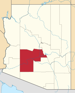
Waddell, Arizona | |
---|---|
Coordinates: 33°36′41″N112°25′38″W / 33.61139°N 112.42722°W | |
Country | United States |
State | Arizona |
County | Maricopa |
Elevation | 1,200 ft (400 m) |
Time zone | UTC-7 (Mountain (MST)) |
ZIP code | 85355 [1] |
Area code | 623 |
Waddell is an unincorporated community in Maricopa County, Arizona, United States, northwest of the city of Phoenix. Waddell is named after Donald Ware Waddell, a native of Ohio, who was a partner in the New York City investment firm of Brandon, Gordon and Waddell. It was this firm that organized the private financing for construction of the dam for the water reclamation project that creates Lake Pleasant. [2] The intended Waddell town site was laid out by Donald W. Waddell in 1935, on property he owned on the northeast corner of Waddell Road and Cotton Lane (Section 12, T3N, R2W, G&SRB&M). [3] Waddell moved to the area to oversee the firm's interests in the project. He served on the board of the Maricopa Water District and invested in land through his interests in the Arizona Citrus Land Company and the Waddell Ranch Company.
In 1937, the Waddell Post Office was established inside the store on the original town site. Later, the post office moved across the street and shared space with the cotton gin office. The current Waddell Post Office was built in 1992 and is located on Glendale Avenue and Cotton Lane, four miles south of the original site. The town never did develop, but remained a post office and place name for the area. [4]
The dam on the Agua Fria River that creates Lake Pleasant (once called Frog Tanks Dam then, Pleasant Dam) was renamed for Donald W. Waddell in 1963, shortly after his death, in recognition of his contributions to the Maricopa Water District. Barry M. Goldwater spoke at the dedication ceremony. [5]
With the expansion of the city of Surprise, use of the name Waddell to describe the location is rapidly falling into disuse. Influence of the name can still be seen in the name of Waddell Road, an arterial street running through Surprise, as well as the New Waddell Dam at Lake Pleasant. In November 2010 the White Tank Regional Library opened. [6]
The community contains the Wat Promkunaram Buddhist Temple. This facility was the site of a mass shooting in 1991 which left nine people dead, among them monks and temple helpers. It remains the deadliest homicide incident in Arizona history since statehood. Sixteen-year-old Alessandro Garcia and 17-year-old Jonathan Doody were charged with the crime, convicted, and sentenced. Doody was tried three times and sentenced to 281 years of prison in 2014. [7]
Phoenix is the capital and most populous city of the U.S. state of Arizona, with 1,608,139 residents as of 2020. It is the fifth-most populous city in the United States and the most populous state capital in the country.
Maricopa County is in the south-central part of the U.S. state of Arizona. As of the 2020 census the population was 4,420,568, or about 62% of the state's total, making it the fourth-most populous county in the United States and the most populous county in Arizona, and making Arizona one of the nation's most centralized states. The county seat is Phoenix, the state capital and fifth-most populous city in the United States.
Gila Bend, founded in 1872, is a town in Maricopa County, Arizona, United States. The town is named for an approximately 90-degree bend in the Gila River, which is near the community's current location. As of the 2020 census, the population of the town was 1,892.
Peoria is a city in Maricopa and Yavapai counties in the U.S. state of Arizona. Most of the city is located in Maricopa County, while a portion of it in the north is in Yavapai County. It is a major suburb of Phoenix. As of the 2020 census, the population of Peoria was 190,985, up from 154,065 in 2010. It is the sixth-largest city in Arizona in land area and the ninth-largest in population. It was named after Peoria, Illinois. The word peoria is a corruption of the Miami-Illinois word for "prairie fire". It is the spring training home of the San Diego Padres and Seattle Mariners, who share the Peoria Sports Complex.
Tempe is a city in Maricopa County, Arizona, United States, with the Census Bureau reporting a 2020 population of 180,587. The city is named after the Vale of Tempe in Greece. Tempe is located in the East Valley section of metropolitan Phoenix; it is bordered by Phoenix and Guadalupe on the west, Scottsdale and the Salt River Pima–Maricopa Indian Community on the north, Chandler on the south, and Mesa on the east. Tempe is also the location of the main campus of Arizona State University.
The Salt River is a river in Gila and Maricopa counties in Arizona, United States, that is the largest tributary of the Gila River. The river is about 200 miles (320 km) long. Its drainage basin covers about 13,700 square miles (35,000 km2). The longest of the Salt River's many tributaries is the 195-mile (314 km) Verde River. The Salt's headwaters tributaries, the Black River and East Fork, increase the river's total length to about 300 miles (480 km). The name Salt River comes from the river's course over large salt deposits shortly after the merging of the White and Black Rivers.
The Phoenix metropolitan area, also known as the Valley of the Sun, the Salt River Valley, metro Phoenix, or The Valley, is the largest metropolitan statistical area in the Southwestern United States, with its largest principal city being the city of Phoenix. It includes much of central Arizona. The United States Office of Management and Budget designates the area as the Phoenix–Mesa–Chandler Metropolitan Statistical Area (MSA), defining it as Maricopa and Pinal counties. It anchors the Arizona Sun Corridor megaregion along with the second-most populous metropolitan area in the state, the Tucson metropolitan area. The gross domestic product of the Phoenix metropolitan area was $255 billion in 2018, 16th highest amongst metro areas in the United States.
The Central Arizona Project (CAP) is a 336 mi (541 km) diversion canal in Arizona in the southern United States.
Lake Pleasant Regional Park is a large outdoors recreation area straddling the Maricopa and Yavapai county border northwest of Phoenix, Arizona. The park is located within the municipal boundaries of Peoria, Arizona, and serves as a major recreation hub for the northwest Phoenix metropolitan area.
The Agua Fria River is a 120-mile (190 km) long intermittent stream which flows generally south from 20 miles (32 km) east-northeast of Prescott in the U.S. state of Arizona. Prescott draws much of its municipal water supply from the upper Agua Fria watershed. The Agua Fria runs through the Agua Fria National Monument. The river then flows through a small canyon called "Black Canyon" into Lake Pleasant, a popular recreation area near Peoria, Arizona. (There is a large "Black Canyon" on the Colorado River along the Arizona–Nevada border.)
The New Waddell Dam is an embankment dam on the Agua Fria River in Maricopa County, Arizona, 35 miles (56 km) northwest of Phoenix. It serves as part of the Central Arizona Project (CAP) while also providing water for the Maricopa Water District. The dam creates Lake Pleasant with water from the Agua Fria and also the CAP aqueduct. In addition, it affords flood protection, hydroelectric power production and recreational opportunities. Construction on the dam began in 1985 and ended in 1994. Its reservoir submerged the Old Waddell Dam which was completed in 1927 after decades of planning.
Arizona State Route 303 or Loop 303, also known as the Bob Stump Memorial Parkway, is a freeway that serves the west part of the Phoenix metropolitan area. The freeway, originally a two-lane rural highway, was maintained by Maricopa County until 2004 when the Arizona Department of Transportation again took control of upgrading the interim road to a freeway.
The Maricopa County Library District is a public library system located in central Arizona, United States. It is the largest library system in the US by population served.
The Maricopa County Sheriff's Office (MCSO) is the law enforcement agency that serves Maricopa County, Arizona, and is the largest sheriff's office in Arizona. The MCSO provides patrol services and criminal investigation to unincorporated areas of the county and operates the county jail system. It also serves as the primary law enforcement agency for any incorporated cities within the county that have contracted with the agency for law-enforcement services. The county sheriff is elected by the citizens and serves as the highest law enforcement official in Maricopa County. The current Sheriff of Maricopa County is Paul Penzone, elected in 2016. As a result of policies and practices under former sheriff Joe Arpaio the MCSO has received significant critical media coverage, federal investigation, and judicial oversight.
Many arterial roads in the Phoenix metropolitan area have the same name in multiple cities or towns. Some roads change names or route numbers across town borders, resulting in occasional confusion. For example, the road known as Apache Boulevard in Tempe continues east as Main Street in neighboring Mesa and then as Apache Trail in Apache Junction. Although Broadway Road maintains the same name through Goodyear, Avondale, Phoenix, Tempe, Mesa, and Apache Junction, each town uses a different reference point for address numbers.
Sunflower is a region of Maricopa County, Arizona, United States adjacent to the Mazatzal Wilderness, west of Tonto National Forest and northwest of Roosevelt Reservoir. Formerly a mercury-mining district, Sunflower is now a destination for hikers, campers and off-road vehicle tours. Sunflower is located near Arizona State Route 87, 22.8 miles (36.7 km) northeast of Fountain Hills. Route 87 near Sunflower is called the Beeline Highway.
The following is a timeline of the history of the city of Phoenix, Arizona, United States.
In the early hours of August 10, 1991, a mass shooting occurred at Thai Buddhist temple Wat Promkunaram in Waddell, Arizona, killing nine people. At the time, this was the deadliest mass shooting at a place of worship in U.S. history, until it was paralleled by the Charleston church shooting in 2015, which also killed nine people, and then superseded by the Sutherland Springs church shooting in Texas in 2017. As of 2024, it is the deadliest mass shooting in Arizona history.
William H. Beardsley (1850–1925) was an irrigation pioneer and inventor from Ohio who helped irrigate part of the West Valley of Phoenix, Arizona.
{{cite journal}}
: Cite journal requires |journal=
(help)Media related to Waddell, Arizona at Wikimedia Commons