
The City of Idaho Springs is the statutory city that is the most populous municipality in Clear Creek County, Colorado, United States. Idaho Springs is a part of the Denver–Aurora–Lakewood, CO Metropolitan Statistical Area. As of the 2020 census it had a population of 1,782. Idaho Springs is located in Clear Creek Canyon, in the mountains upstream from Golden, some 30 miles (50 km) west of Denver.

Bisbee is a city in and the county seat of Cochise County in southeastern Arizona, United States. It is 92 miles (148 km) southeast of Tucson and 11 miles (18 km) north of the Mexican border. According to the 2020 census, the population of the town was 4,923, down from 5,575 in the 2010 census.
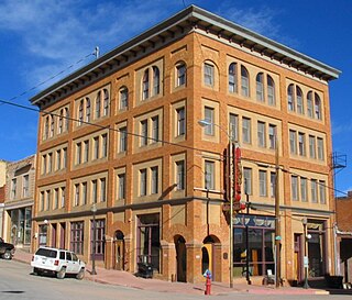
The City of Victor is a Statutory City in Teller County, Colorado, United States. Gold was discovered in Victor in the late 19th century, an omen of the future of the town. With Cripple Creek, the mining district became the second largest gold mining district in the country and realized approximately $10 billion of mined gold in 2010 dollars. It reached its peak around the turn of the century when there were about 18,000 residents in the town. Depleted ore in mines, labor strife and the exodus of miners during World War I caused a steep decline in the city's economy, from which it has never recovered. The population was 379 at the 2020 census. There is a resumed mining effort on Battle Mountain.

A gold rush or gold fever is a discovery of gold—sometimes accompanied by other precious metals and rare-earth minerals—that brings an onrush of miners seeking their fortune. Major gold rushes took place in the 19th century in Australia, Greece, New Zealand, Brazil, Chile, South Africa, the United States, and Canada while smaller gold rushes took place elsewhere.
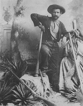
George Warren worked as a prospector in the Tombstone and Bisbee, Arizona region during the late 19th century. He is credited with having located the body of copper ore, which later was known as the Copper Queen Mine, one of Arizona's most productive copper mines. Warren drank too much and bet his interest in the mine on a foot race against a horse and lost.

Hatcher Pass is a mountain pass through the southwest part of the Talkeetna Mountains, Alaska. It is named after Robert Hatcher, a prospector and miner. The nearest cities are Palmer and Wasilla approximately 12 miles (19 km) to the south, and Willow approximately 26 mi (42 km) to the west. The communities are at an elevation of approximately 250 ft (76 m) in the Mat-Su valley.
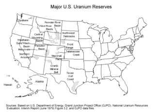
Uranium mining in the United States produced 224,331 pounds (101.8 tonnes) of U3O8 in 2023, 15% of the 2018 production of 1,447,945 pounds (656.8 tonnes) of U3O8. The 2023 production represents 0.4% of the uranium fuel requirements of the US's nuclear power reactors for the year. Production came from five in-situ leaching plants, four in Wyoming (Nichols Ranch ISR Project, Lance Project, Lost Creek Project, and Smith Ranch-Highland Operation) and one in Nebraska (Crowe Butte Operation); and from the White Mesa conventional mill in Utah.
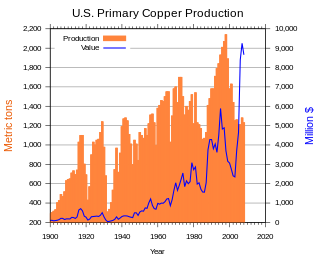
In the United States, copper mining has been a major industry since the rise of the northern Michigan copper district in the 1840s. In 2017, the US produced 1.27 million metric tonnes of copper, worth $8 billion, making it the world's fourth largest copper producer, after Chile, China, and Peru. Copper was produced from 23 mines in the US. Top copper producing states in 2014 were Arizona, Utah, New Mexico, Nevada, and Montana. Minor production also came from Idaho and Missouri. As of 2014, the US had 45 million tonnes of known remaining reserves of copper, the fifth largest known copper reserves in the world, after Chile, Australia, Peru, and Mexico.

In the United States, gold mining has taken place continually since the discovery of gold at the Reed farm in North Carolina in 1799. The first documented occurrence of gold was in Virginia in 1782. Some minor gold production took place in North Carolina as early as 1793, but created no excitement. The discovery on the Reed farm in 1799 which was identified as gold in 1802 and subsequently mined marked the first commercial production.
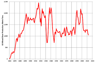
Silver mining in the United States began on a major scale with the discovery of the Comstock Lode in Nevada in 1858. The industry suffered greatly from the demonetization of silver in 1873 by the Coinage Act of 1873, known pejoratively as the "Crime of 73", but silver mining continues today.
Gold mining in Colorado, a state of the United States, has been an industry since 1858. It also played a key role in the establishment of the state of Colorado.
Silver mining in Nevada, a state of the United States, began in 1858 with the discovery of the Comstock Lode, the first major silver-mining district in the United States. Nevada calls itself the "Silver State." Nevada is the nation's second-largest producer of silver, after Alaska. In 2014 Nevada produced 10.93 million troy ounces of silver, of which 6.74 million ounces were as a byproduct of the mining of gold. The largest byproducers were the Hycroft Mine, the Phoenix Mine, the Midas Mine and Round Mountain.

In Arizona, copper mining has been a major industry since the 19th century. In 2007, Arizona was the leading copper-producing state in the country, producing 750 thousand metric tons of copper, valued at $5.54 billion. Arizona's copper production was 60% of the total for the United States. Copper mining also produces gold and silver as byproducts. Byproduct molybdenum from copper mining makes Arizona the nation's second-largest producer of that metal. Although copper mineralization was found by the earliest Spanish explorers of Arizona, the territory was remote, and copper could seldom be profitably mined and shipped. Early Spanish, Mexican, and American prospectors searched for gold and silver, and ignored copper. It was not until the completion of the Southern Pacific Railroad in 1876 that copper became broadly economic to mine and ship to market.
Gold mining in Alaska, a state of the United States, has been a major industry and impetus for exploration and settlement since a few years after the United States acquired the territory in 1867 from the Russian Empire. Russian explorers discovered placer gold in the Kenai River in 1848, but no gold was produced. Gold mining started in 1870 from placers southeast of Juneau, Alaska.
The Copper Queen Mine was a copper mine in Cochise County, Arizona, United States. Its development led to the growth of the surrounding town of Bisbee in the 1880s. Its orebody ran 23% copper, an extraordinarily high grade. It was acquired by Phelps Dodge in 1885.

The New Cornelia mine is a currently inactive open-pit copper mine in Pima County, Arizona, United States. It was the only productive mine in the Ajo mining district, and is located just outside the town of Ajo, which was built as a company town to serve the New Cornelia mines. The roughly circular pit is one and a half miles across at its widest point, and 1,100 feet deep at the center. Although not generally regarded as a 'dam', the New Cornelia Mine Tailings is often cited as the largest dam structure in the United States with a volume of 7.4 billion cubic feet.
Mining in the United States has been active since the beginning of colonial times, but became a major industry in the 19th century with a number of new mineral discoveries causing a series of mining rushes. In 2015, the value of coal, metals, and industrial minerals mined in the United States was US$109.6 billion. 158,000 workers were directly employed by the mining industry.

El Dorado Canyon is a canyon in southern Clark County, Nevada famed for its rich silver and gold mines. The canyon was named in 1857 by steamboat entrepreneur Captain George Alonzo Johnson when gold and silver was discovered here. It drains into the Colorado River at the former site of Nelson's Landing.

The Juneau gold belt is located in the southeastern portion of the U.S. state of Alaska. This belt is approximately 100 miles (160 km) in length, north/northwest-trending, and extends from Berners Bay southeastward to Windham Bay, 60 miles (97 km) southeast of Juneau, and includes Douglas Island. The belt contains over 200 gold-quartz-vein deposits with production nearing 7,000,000 ounces (200,000,000 g) of gold. More than three-quarters of Alaska's lode gold was mined from the Juneau gold belt.
Roderick R. Asher (1931-1997) was an American geologist and mining engineer, best known for his field work in Mexico, Alaska, and the Great Basin region of the United States as well as his published works.

