Related Research Articles

McDermitt is an unincorporated community straddling the Nevada–Oregon border, in Humboldt County, Nevada, and Malheur County, Oregon, United States. McDermitt's economy has historically been based on mining, ranching, and farming. The last mining operation closed in 1990, resulting in a steady decline in population.

Empire Mine State Historic Park is a state-protected mine and park in the Sierra Nevada mountains in Grass Valley, California, U.S. The Empire Mine is on the National Register of Historic Places, a federal Historic District, and a California Historical Landmark. Since 1975 California State Parks has administered and maintained the mine as a historic site. The Empire Mine is "one of the oldest, largest, deepest, longest and richest gold mines in California". Between 1850 and its closure in 1956, the Empire Mine produced 5.8 million ounces of gold, extracted from 367 miles (591 km) of underground passages.

The Monte Cristo Gold Mine is a gold mine in the San Gabriel Mountains near Los Angeles, California, USA.
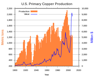
Copper mining in the United States has been a major industry since the rise of the northern Michigan copper district in the 1840s. In 2017, the United States produced 1.27 million metric tonnes of copper, worth $8 billion, making it the world's fourth largest copper producer, after Chile, China, and Peru. Copper was produced from 23 mines in the US. Top copper producing states in 2014 were Arizona, Utah, New Mexico, Nevada, and Montana. Minor production also came from Idaho, and Missouri. As of 2014, the US had 45 million tonnes of known remaining reserves of copper, the fifth largest known copper reserves in the world, after Chile, Australia, Peru, and Mexico.

Gold mining in the United States has taken place continually since the discovery of gold at the Reed farm in North Carolina in 1799. The first documented occurrence of gold was in Virginia in 1782. Some minor gold production took place in North Carolina as early as 1793, but created no excitement. The discovery on the Reed farm in 1799 which was identified as gold in 1802 and subsequently mined marked the first commercial production.
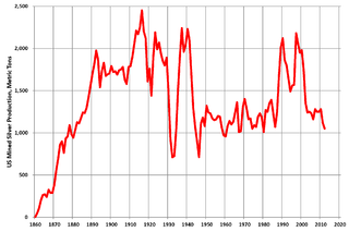
Silver mining in the United States began on a major scale with the discovery of the Comstock Lode in Nevada in 1858. The industry suffered greatly from the demonetization of silver in 1873 by the Coinage Act of 1873, known pejoratively as the "Crime of 73", but silver mining continues today.
Gold mining in Colorado, a state of the United States, has been an industry since 1858. It also played a key role in the establishment of the state of Colorado.
Silver mining in Nevada, a state of the United States, began in 1858 with the discovery of the Comstock Lode, the first major silver-mining district in the United States. Nevada calls itself the "Silver State." Nevada is the nation's second-largest producer of silver, after Alaska. In 2014 Nevada produced 10.93 million troy ounces of silver, of which 6.74 million ounces were as a byproduct of the mining of gold. The largest byproducers were the Hycroft Mine, the Phoenix Mine, the Midas Mine and Round Mountain.
Gold mining in Alaska, a state of the United States, has been a major industry and impetus for exploration and settlement since a few years after the United States acquired the territory in 1867 from the Russian Empire. Russian explorers discovered placer gold in the Kenai River in 1848, but no gold was produced. Gold mining started in 1870 from placers southeast of Juneau, Alaska.

Gold mining in Nevada, a state of the United States, is a major industry, and one of the largest sources of gold in the world. In 2018 Nevada produced 5,581,160 troy ounces, representing 78% of US gold and 5.0% of the world's production. Total gold production recorded from Nevada from 1835 to 2017 totals 205,931,000 troy ounces (6,405.2 t), worth US$322.6 billion at 2020 values. Much of Nevada's gold production comes from large open pit mining using heap leaching recovery.

The Leadville mining district, located in the Colorado Mineral Belt, was the most productive silver-mining district in the state of Colorado and hosts one of the largest lead-zinc-silver deposits in the world. Oro City, an early Colorado gold placer mining town located about a mile east of Leadville in California Gulch, was the location to one of the richest placer gold strikes in Colorado, with estimated gold production of 120,000–150,000 ozt, worth $2.5 to $3 million at the then-price of $20.67 per troy ounce.

Castle Dome Landing, Arizona is a ghost town in the Castle Dome Mountains of Yuma County in the U.S. state of Arizona. It was first settled as a transport depot and mining camp around 1863 in what was then the Arizona Territory.

Good Hope Mine was the principal gold mine in the Pinacate Mining District, Riverside County, California.
Maybert was a mining town in Nevada County, California. It was located on the south side of the South Yuba River, about 6 miles east of the town of Washington, at an elevation of 3,245 ft (989 m). Fall Creek empties into the South Yuba slightly to the northwest of the town site.
Banner is an unincorporated community in San Diego County, California. It lies at an elevation of 2743 feet. It is located on California State Route 78.

Confederate Gulch is a steeply incised gulch or valley on the west-facing slopes of the Big Belt Mountains in the U.S. state of Montana. Its small stream drains westward into Canyon Ferry Lake, on the upper Missouri River near present-day Townsend, Montana. In 1864, Confederate soldiers on parole during the American Civil War made a minor gold discovery in the gulch, but the discovery of the sensationally rich Montana Bar the following year—one of the richest placer strikes per acre ever made—led to other rich gold strikes up and down the gulch, and touched off a frantic boom period of placer gold mining in the area that extended through 1869. From 1866 to 1869, the gulch equaled or outstripped all other mining camps in the Montana Territory in gold production, producing an estimated $19–30 million worth of gold. For a time, Confederate Gulch was the largest community in Montana. In 1866, Montana had a total population of 28,000, and of these, about 10,000 (35%) were working in Confederate Gulch.

Gold Rush is a reality television series that airs on Discovery and its affiliates worldwide. The series follows the placer gold mining efforts of various family-run mining companies, mostly in the Klondike region of Dawson City, Yukon, Canada, as well as in the U.S. state of Alaska. In its 12th season as of early 2021, prior seasons also included mining efforts in South America and western North America.
Democrat, originally Democrat Hill, is a former settlement in Nevada County, California. It lay on the Chalk Bluff ridge, about 1 mile south of what is now Highway 20, about 6 miles southeast of the town of Washington and about 1 mile east of Remington Hill. Its elevation was 4170 feet. It lay on a gold bearing gravel channel on the Chalk Bluff Ridge, which lies between Steephollow and Greenhorn Creeks, tributaries of the Bear River. As the channel runs southwest, it joins a major channel running from the San Juan Ridge easterly through Red Dog and You Bet into Placer County.
Gaston is the site of a former mining community in Nevada County, California. Gaston lies at an elevation of 5062 feet on the Gaston Ridge. The Gaston Ridge historically, was often referred to as God's Country, because of its wild and somewhat inaccessible beauty. Gaston is located 3.25 miles (5.2 km) south of Graniteville and about 4 miles northeast of the town of Washington. It is near the intersection of what are now Gaston and Hoosier Roads, in the Tahoe National Forest.

Kingston is a census-designated place (CDP) in Sierra County, New Mexico, United States. Its population was 32 as of the 2010 census. The community is located in the Black Range along New Mexico State Road 152.
References
- Report of the State Mineralogist, California State Mining Bureau, State Office, 1893, pg. 384-385
- Report of the State Mineralogist, California State Mining Bureau, State Office, 1894, pg 220-223
- Tom Hudson, Lake Elsinore Valley, its story 1776-1977, 2nd Ed., Published by author, 1988. ISBN 0-931700-01-9
- Western Mining History, Riverside County California Gold Production
Coordinates: 33°44′N117°17′W / 33.74°N 117.29°W
| | This Riverside County, California-related article is a stub. You can help Wikipedia by expanding it. |