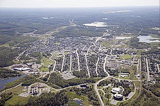
Kirkland Lake is a town and municipality in Timiskaming District of Northeastern Ontario. The 2021 population, according to Statistics Canada, was 7,750.

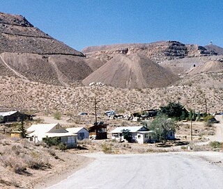
Skidoo was an unincorporated community in Inyo County, California. The geographical location of the old town site lies at an elevation of 5,689 feet. Skidoo is a ghost town located in Death Valley National Park. It is on the National Register of Historic Places.

The Comstock Lode is a lode of silver ore located under the eastern slope of Mount Davidson, a peak in the Virginia Range in Virginia City, Nevada, which was the first major discovery of silver ore in the United States and named after American miner Henry Comstock.

Empire Mine State Historic Park is a state-protected mine and park in the Sierra Nevada mountains in Grass Valley, California, U.S. The Empire Mine is on the National Register of Historic Places, a federal Historic District, and a California Historical Landmark. Since 1975 California State Parks has administered and maintained the mine as a historic site. The Empire Mine is "one of the oldest, largest, deepest, longest and richest gold mines in California". Between 1850 and its closure in 1956, the Empire Mine produced 5.8 million ounces of gold, extracted from 367 miles (591 km) of underground passages.

The Monte Cristo Gold Mine is a gold mine in the San Gabriel Mountains near Los Angeles, California, USA.
Picacho is an unincorporated community in Imperial County, California. It is located on the Colorado River 29 miles (47 km) south-southeast of Palo Verde, at an elevation of 203 feet.

Quartz reef mining is a type of gold mining in "reefs" (veins) of quartz. Quartz is one of the most common minerals in the Earth's crust, and most quartz veins do not carry gold, but those that have gold are avidly hunted by prospectors. In the shallow, oxidized zones of quartz reef deposits, the gold occurs in its metallic state, and is easily recovered with simple equipment. Quartz reef mining played an important role in 19th century gold-mining districts such as Bendigo, Victoria in Australia, Central Otago in New Zealand, and the California mother lode.

The Keane Wonder Mine and mill is an abandoned mining facility located within Death Valley National Park in Inyo County, California. It is located in the Funeral Mountains east of Death Valley and Furnace Creek, California
The Pinacate Mining District is 5 to 8 miles southwest of Perris, California. It included the Good Hope Mine, Steele's Mine, Santa Rosa (Rosalia) Mine, Virginia or Shay Mine, Santa Fe Mine and many other smaller works like the Little Maggie Mine. It produced a total of about 104,000 ounces of gold through 1959, all from the lodes of various mines. The district declined until the mid-1930s, when attempts were made to rehabilitate the Good Hope and several other mines. These efforts were largely unsuccessful, the Good Hope mine closed when it was flooded with underground water. Only three ounces of gold were produced in the district between 1943 and 1959.
Terra Cotta is a former mining town in Riverside County. It was established in 1887, in the Warm Springs Valley northwest of the town of Lake Elsinore, and later incorporated into the City of Lake Elsinore.
The Bodie Mine is an inactive, privately owned gold mine in Okanogan County, Washington, United States. It is located within a triangle formed by the town of Wauconda, Washington the original town of Bodie, Washington, and the later ghost town of Bodie, on Toroda Road.
The North Star Mine and Powerhouse are located on Lafayette Hill a short distance south of Grass Valley in the U.S. state of California. It was the second largest producer of gold during California's Gold Rush. In 1898, the largest Pelton wheel for its time was built for the mine. The North Star Mine Company also owned locations on Weimar Hill, adjoining and south of the North Star Mine. It shut down during World War II after its consolidation with the Empire Mine.
The Fort Knox Gold Mine is an open pit gold mine, 9 mi (14 km) east of Fox in the Fairbanks mining district of Alaska. It is owned and operated by Toronto-based Kinross Gold. Originally staked in 1913, after very minor mining at the location the property sat idle until being restaked in 1980. Following the initial exploration discovery in 1987, in 1992 the project was purchased by Amax Gold, which brought the mine to production. Amax Gold merged with Kinross Gold in 1998.
Kearsarge or Kearsarge City is a former mining settlement in Inyo County, eastern California. It was located high on the east slope of the Sierra Nevada, near Kearsage Pass, 8 miles (13 km) west of present-day town of Independence, California.
Crystal Mine is located near Juneau in the U.S. state of Alaska. The quartz ledge at the Crystal Mine was first discovered in 1895 by B. Heins. It was so named because of the large pyrite cubes which were found occurring in the surface outcrops of the ledge. Gold was extracted till 1905 from quartz using ten-stamp mill and from about 1,000 feet of underground workings yielded 1,210 ounces of gold. Intermittent production of gold is reported till 1925 but there are no records of the yield. The formation was determined as of 54 to 56 Ma age. The gold yielding resources available from the mine were assessed as 9,000 tons of material with yield of 0.21 ounce of gold per ton.
Gavilan Hills, sometimes called the Gavilan Mountains, are a range of the Temescal Mountains, in Riverside County, California. The name given them came from local New Mexican and Californio miners of the mountains and Gavilan Plateau. In Spanish Gavilan, means "sparrow hawk".
Gavilan Mining District is a gold mining district 6 miles west of Perris, California and Gavilan Hills and east of Gavilan Peak on the Gavilan Plateau in Riverside County, California. It includes only 2 mines: the Ida Leona Mine and the Gavilan Mine located within yards of each other.
Hedges, later renamed Tumco, is a locale, a ghost town, site of a former mining town, in Imperial County, California. It lies at an elevation of 617 feet / 188 meters along the Tumco Wash in the Cargo Muchacho Mountains. Nearby is the Hedges Cemetery at an elevation of 643 feet, at 32°53′04″N114°49′52″W.

Champion-Providence Mine was a consolidation of two adjoining gold mines in Nevada City, California subsequent to the California Gold Rush. After it became the Champion Group following annexation of additional adjacent mining concerns, it became one of the two most productive mining groups in the Nevada City Mining District, alongside the North Star Mine, which purchased it in 1911. The Champion-Providence Mine closed in 1920.
Yellow Aster Mine was a large gold mine in Southern California.
