
Gila Bend, founded in 1872, is a town in Maricopa County, Arizona, United States. The town is named for an approximately 90-degree bend in the Gila River, which is near the community's current location. According to the 2010 census, the population of the town is 1,922.
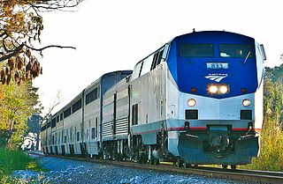
The Sunset Limited is an Amtrak passenger train that for most of its history has run between New Orleans and Los Angeles, over the nation's second transcontinental route. However, up until Hurricane Katrina in 2005, it ran between Orlando and Los Angeles, and from 1993 to 1996, continued on to Miami. It is the oldest continuously operating named train in the United States, introduced in 1894 by the Southern Pacific Railroad, and acquired by Amtrak upon its formation in 1971.

Caliente is an unincorporated community in Kern County, California. It is located 22 miles (35 km) east-southeast of Bakersfield, at an elevation of 1,312 feet (400 m).

Stanwix Station, in western Arizona, was a stop on the Butterfield Overland Mail Stagecoach line built in the later 1850s near the Gila River about 80 miles (130 km) east of Yuma, Arizona. Originally the station was called Flap Jack Ranch later Grinnell's Ranch or Grinnell's Station. In 1862, Grinnell's was listed on the itinerary of the California Column in the same place as Stanwix Ranch which became the site of the westernmost skirmish of the American Civil War. A traveler in 1864, John Ross Browne, wrote Grinnell's was six miles southwest of the hot springs of Agua Caliente, Arizona.

Tucson is an Amtrak train depot in Tucson, Arizona, served three times a week by the Sunset Limited and Texas Eagle trains.

Yuma is an Amtrak station at 281 South Gila Street in Yuma, Arizona, United States. Passenger rail service is provided thrice-weekly in each direction by the Sunset Limited and the Texas Eagle over this portion of its route. The station's island platform, which is adjacent to the station building site, are accessible through a short pedestrian tunnel.

Mohawk is a populated place in Yuma County, Arizona, United States. It is part of the Yuma Metropolitan Statistical Area.
Warner Springs is set of springs and a small unincorporated community in northern San Diego County, California.

The Yuma War was the name given to a series of United States military operations conducted in southern California and what is today southwestern Arizona from 1850 to 1853. The Quechan were the primary opponent of the United States Army, though engagements were fought between the Americans and other native groups in the region.

Southern Emigrant Trail, also known as the Gila Trail, the Kearny Trail, Southern Trail and the Butterfield Stage Trail, was a major land route for immigration into California from the eastern United States that followed the Santa Fe Trail to New Mexico during the California Gold Rush. Unlike the more northern routes, pioneer wagons could travel year round, mountain passes not being blocked by snows, however it had the disadvantage of summer heat and lack of water in the desert regions through which it passed in New Mexico Territory and the Colorado Desert of California. Subsequently, it was a route of travel and commerce between the eastern United States and California. Many herds of cattle and sheep were driven along this route and it was followed by the San Antonio-San Diego Mail Line in 1857-1858 and then the Butterfield Overland Mail from 1858 - 1861.
The Sunset Route is a main line of the Union Pacific Railroad running between Southern California and New Orleans, Louisiana.

Agua Caliente in Maricopa County, Arizona on the border with Yuma County, is a place north of the Gila River near Hyder, Arizona. Named 'Santa Maria del Agua Caliente' in 1744 by Father Jacob Sedelmayer. In 1775, Father Francisco Garces used the current short form. The location was the site of a resort established at the site of nearby hot springs. Agua Caliente, a name derived from Spanish meaning "hot water", received its name from nearby hot springs which were originally used by the local Indians.
Pima Villages, sometimes mistakenly called the Pimos Villages in the 19th century, were the Akimel O’odham (Pima) and Pee-Posh (Maricopa) villages in what is now the Gila River Indian Community in Pinal County, Arizona. First, recorded by Spanish explorers in the late 17th century as living on the south side of the Gila River, they were included in the Viceroyalty of New Spain, then in Provincias of Sonora, Ostimuri y Sinaloa or New Navarre to 1823. Then from 1824 to 1830, they were part of the Estado de Occidente of Mexico and from September 1830 they were part of the state of Sonora. These were the Pima villages encountered by American fur trappers, traders, soldiers and travelers along the middle Gila River from 1830s into the later 19th century. The Mexican Cession following the Mexican American War left them part of Mexico. The 1853 Gadsden Purchase made their lands part of the United States, Territory of New Mexico. During the American Civil War, they became part of the Territory of Arizona.

The Agua Caliente Mountains are a small range in eastern Yuma and western Maricopa counties in southwest Arizona. The community of Hyder is on the north side of the range adjacent to the Union Pacific rail line and Hyder Road. The community of Agua Caliente lies on the south flank of the range and the Gila River lies to the south.

The Camp Hyder was a sub camp of the US Army, Desert Training Center in Riverside County, California. The main headquarters for the Desert Training Center was Camp Young, this is where General Patton's 3rd Armored Division was stationed. Camp Hyder is 2 miles (3.2 km) miles south of Hyder, Arizona. The camp was just north of the Gila River. Camp Hyder is 60 miles (97 km) miles east of Yuma, Arizona, near Camp Horn. Camp Hyder was built at the site of an old 1890s military base. Trained at Camp Hyder, in 1943, for six months was the 77th Infantry Division from April 1943 to September 1943. Then the 104th Infantry Division moved in for training. Unlike the other camps, no large tank activity was done. The camp was built by The 369th Engineer Regiment. Camp Hyder had it own rail station at which most troops arrived. The train station at Sentinel, Arizona south of the camp was also used. Over 13,000 troops were trained at Camp Horn and Camp Hyder.
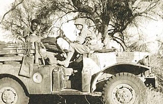
The Camp Horn was a sub camp of the US Army, Desert Training Center in Riverside County, California. The main headquarters for the Desert Training Center was Camp Young, this is where General Patton's 3rd Armored Division was stationed. Camp Horn was near Camp Hyder about 6 miles (9.7 km) miles west of Hyder, Arizona. Camp Horn was just north of the Gila River. Camp Horn was 54 miles (87 km) miles east of Yuma, Arizona. Most troop arrived at Camp Horn from the train station at Camp Hyder or the train station at Sentinel, Arizona south of the camp. Over 13,000 troops were trained at Camp Horn and Camp Hyder. The 81st Infantry Division trained at Camp Horn was from June 1943 to November 1943.
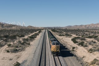
The Phoenix Subdivision is a railroad line in the U.S. state of Arizona that is owned by the Union Pacific Railroad. The southeast end of the line connects to the Gila Subdivision near Eloy, runs northeast to Phoenix, and becomes the Roll Industrial Lead, running southwest before reconnecting to the Gila Subdivision at Wellton. As of 2010, eighty miles (130 km) of the line between Roll and Arlington are out of service and used for car storage.


