Related Research Articles
The Quechan, or Yuma, are a Native American tribe who live on the Fort Yuma Indian Reservation on the lower Colorado River in Arizona and California just north of the Mexican border. Despite their name, they are not related to the Quechua people of the Andes. Members are enrolled into the Quechan Tribe of the Fort Yuma Indian Reservation. The federally recognized Quechan tribe's main office is located in Winterhaven, California. Its operations and the majority of its reservation land are located in California, United States.

Yuma is a city in and the county seat of Yuma County, Arizona, United States. The city's population was 95,548 at the 2020 census, up from the 2010 census population of 93,064.
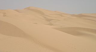
The Yuma Desert is a lower-elevation section of the Sonoran Desert in the southwestern United States and the northwest of Mexico. It lies in the Salton basin. The desert contains areas of sparse vegetation and has notable areas of sand dunes. With an average rainfall less than 8 inches (200 mm) each year, it is among the harshest deserts in North America. Human presence is sparse throughout, the largest city being Yuma, Arizona, on the Colorado River and the border of California.
La Paz was a short-lived early gold mining town along on the western border of current-day La Paz County, Arizona. The town grew quickly after gold was discovered nearby in 1862. La Paz, Spanish for peace, was chosen as the name in recognition of the feast day for Our Lady of Peace. Originally located in the New Mexico Territory, the town became part of the Arizona Territory when President Abraham Lincoln established the new territory in 1863. In 1983 the newly-formed County of La Paz adopted the name, long after the town had become a ghost town.

Castle Dome Landing, Arizona is a ghost town in the Castle Dome Mountains of Yuma County in the U.S. state of Arizona. It was first settled as a transport depot and mining camp around 1863 in what was then the Arizona Territory.

The Yuma War was the name given to a series of United States military operations conducted in southern California and what is today southwestern Arizona from 1850 to 1853. The Quechan were the primary opponent of the United States Army, though engagements were fought between the Americans and other native groups in the region.

Southern Emigrant Trail, also known as the Gila Trail, the Kearny Trail, Southern Trail and the Butterfield Stage Trail, was a major land route for immigration into California from the eastern United States that followed the Santa Fe Trail to New Mexico during the California Gold Rush. Unlike the more northern routes, pioneer wagons could travel year round, mountain passes not being blocked by snows; however, it had the disadvantage of summer heat and lack of water in the desert regions through which it passed in New Mexico Territory and the Colorado Desert of California. Subsequently, it was a route of travel and commerce between the eastern United States and California. Many herds of cattle and sheep were driven along this route and it was followed by the San Antonio-San Diego Mail Line in 1857–1858 and then the Butterfield Overland Mail from 1858 to 1861.

Steamboats on the Colorado River operated from the river mouth at the Colorado River Delta on the Gulf of California in Mexico, up to the Virgin River on the Lower Colorado River Valley in the Southwestern United States from 1852 until 1909, when the construction of the Laguna Dam was completed. The shallow draft paddle steamers were found to be the most economical way to ship goods between the Pacific Ocean ports and settlements and mines along the lower river, putting in at landings in Sonora state, Baja California Territory, California state, Arizona Territory, New Mexico Territory, and Nevada state. They remained the primary means of transportation of freight until the advent of the more economical railroads began cutting away at their business from 1878 when the first line entered Arizona Territory.
Pedrick's was a steamboat landing owned by John Pedrick that supplied wood to steamboats on the lower Colorado River in Sonora, Mexico, from the mid 1850s to the late 1870s. After the 1854 Gadsden Purchase, Pedrick's was within New Mexico Territory and Arizona Territory after 1863. Pedrick's landing was located 24 miles above Ogden's Landing and 31 miles below Fort Yuma. Pedrick's lay along the east bank of the river just above what is now the Sonora – Arizona border in modern Yuma County, Arizona.
Arizona City or Arizona is the name of the original settlement at the Yuma Crossing, in what is now Yuma, Arizona, United States.
Jaeger's Ferry was a major river ferry at the Yuma Crossing of the Colorado River in the 1850s until 1862, 1 mile below Fort Yuma.
Jaeger City, or Jaegerville, was a former settlement in what is now Imperial County, California, at Jaeger's Ferry on the Colorado River a mile downstream from Fort Yuma. It was named for L. J. F. Jaeger who ran the ferry there from 1851.
La Laguna was a gold mining town in New Mexico Territory, now Yuma County, Arizona. It was in existence for a short time from 1860 to 1862. The town was a steamboat landing 20 miles above Yuma, Arizona on the Colorado River. It had a few merchants and a ferry across the Colorado River that served placer miners in the vicinity. When the La Paz gold rush began, La Laguna began to decline and it was soon replaced by Castle Dome Landing, 15 miles to the north, following the discovery of gold in the Castle Dome Mountains. It remained for a time as the site of a store and a ranch, belonging to Jose Redondo, one of the first to mine gold at La Paz.
Eureka or Eureka Landing, is a former mining town and steamboat landing, now a ghost town, on the Arizona bank of the Colorado River in what is now La Paz County, Arizona. It was originally located in Yuma County, Arizona from 1863 through the 1870s.
Williamsport is a former mining town and present day ghost town, on the bank of the Colorado River in La Paz County, Arizona.
Bradshaw's Ferry was a ferry at the crossing point on the Colorado River, of the Bradshaw Trail at Olive City and later at Mineral City and Ehrenburg, between what was then San Diego County, California, and Arizona County, New Mexico Territory. The ferry connected the Bradshaw Trail to the road to the gold placers of La Paz, the first big strike of the Colorado River Gold Rush. From 1863, the La Paz - Wikenburg Road connected the Bradshaw Trail to the new mining boom town settlements in the interior of Arizona Territory.
Hualapai Smith's or Smith's Ferry was a steamboat landing and a ferry crossing and farm on the Sonora bank of the Colorado River, the border between Sonora and Baja California, from the later 1860s to 1878. It was located on the Colorado River in Sonora 20 miles overland from Yuma, Arizona and 30 miles down river from Fort Yuma in 1861.
George A. Johnson & Company was a partnership between three men who pioneered navigation on the Colorado River. Benjamin M. Hartshorne, George Alonzo Johnson and Alfred H. Wilcox. The George A. Johnson & Company was formed in the fall of 1852, and was reorganized as the Colorado Steam Navigation Company in 1869.
Jaeger's Slough, was a former course of the Colorado River, reduced to a slough sometime before 1849. It ran from its head on the north or California) bank of the river, from the main channel, that at that time ran two or three miles northwest and then east of Fort Yuma. The slough rejoined the river at its mouth nearly a mile west of Fort Yuma. The slough can be seen on Lieutenant Amiel Weeks Whipple's 1849 map "Map of a Survey and Reconnaissance of the Vicinity of the Mouth of the Rio Gila". The map shows two Quechan villages along either side of the slough. The slough would have flooded in the high water months of May and June and then been planted with crops as the water receded, the common practice of the native people along the Colorado River.
Antelope Peak Station, a later Butterfield Overland Mail station located 15.14 miles east of Mission Camp, at the foot of Antelope Peak. It replaced Filibusters Camp Station, 6 miles to the west. The Overland Mail Company replaced Filibusters Camp, because Antelope Peak Station had a better water supply. Its location is thought to be 32°42′47″N114°00′54″W. The station was built by John Kilbride in 1857 but did not appear on the stagecoach itinerary until 1859.
References
- ↑ "Chapter XIX. Early Settlements And First Attempts At Organization Of Territory". Southwest.library.arizona.edu. Archived from the original on May 17, 2011. Retrieved March 27, 2011.
- 1 2 Richard E. Lingenfelter, Steamboats on the Colorado River, 1852–1916, University of Arizona Press, Tucson, 1978 Archived January 18, 2016, at the Wayback Machine , p. 15
- ↑ Thomas Edwin Farish, History of Arizona, Volume I. The Filmer Brothers Electrotype Company, San Francisco, 1915. pp. 252–253
32°43′47″N114°37′48″W / 32.72972°N 114.63000°W
Municipalities and communities of Yuma County, Arizona, United States | ||
|---|---|---|
| Cities |  | |
| Town | ||
| CDPs | ||
| Populated places | ||
| Indian reservations | ||
| Ghost towns | ||
| Footnotes | ‡This populated place also has portions in an adjacent county or counties | |