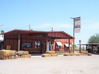
Mohawk is a populated place in Yuma County, Arizona, United States. It is part of the Yuma Metropolitan Statistical Area.

Theba is a census-designated place in Maricopa County, Arizona, United States. Its elevation is 728 feet (222 m). Theba is located along Interstate 8 and is served by Exit 106.

Kofa, also historically known as Kofa Station, is a populated place situated in Yuma County, Arizona, United States. It is located in the northern San Cristobal Valley, along the Union Pacific Railroad's Roll Industrial Lead.

Araby is a populated place now situated within the city limits of Yuma in Yuma County, Arizona, United States. It has an estimated elevation of 217 feet (66 m) above sea level.

Blaisdell is a populated place situated in Yuma County, Arizona, United States, which was named after Hiram W. Blaisdell, who had been in charge of the construction of two nearby canals. It has an estimated elevation of 180 feet (55 m) above sea level. It is located on the Southern Pacific Railroad's Sunset Route and U.S. Route 95 12 miles east of Yuma.

Chiapuk, also known as Copperopolis and Copperosity, is a populated place situated in Pinal County, Arizona, United States. The word Chiapuk means "spring" in the O'odham language, and the variant name Copperosity is derived from the proximity of the Copperosity Mine. During the late 1880s, the local post office was known as the Copperopolis Post Office. It has an estimated elevation of 1,909 feet (582 m) above sea level.

Engesser Junction is a populated place situated in Yuma County, Arizona, United States. It has an estimated elevation of 1,362 feet (415 m) above sea level. It is located in the Kofa Mountains, on the Kofa National Wildlife Refuge. The Engesser mine, originally prospected by Max Engesser, is located nearby.

Graham is a populated place situated in Graham County, Arizona, United States. It has an estimated elevation of 2,887 feet (880 m) above sea level.

Growler is a populated place situated in Yuma County, Arizona, United States. It is located along the Union Pacific Railroad's Roll Industrial Lead. It has an estimated elevation of 322 feet (98 m) above sea level.

Johnson is a populated place situated in Cochise County, Arizona, United States, on the east side of the Little Dragoon Mountains.

Kool Corner is a populated place situated in Yuma County, Arizona, United States. It has an estimated elevation of 154 feet (47 m) above sea level. It is located in the North Gila Valley. Kool Korner was the name of a grocery store.

Laguna is a populated place situated in Pinal County, Arizona, United States. It is one of two places in Arizona with this name, the other being located in Yuma County. It has an estimated elevation of 1,608 feet (490 m) above sea level.

Laguna is a populated place situated in Yuma County, Arizona, United States. It is one of two places in Arizona with this name, the other being located in Pinal County. It has an estimated elevation of 1,608 feet (490 m) above sea level.

Ligurta is a populated place situated in Yuma County, Arizona, United States. It has an estimated elevation of 233 feet (71 m) above sea level. It is located in the Dome Valley south of the Gila River. Established as a railroad station on the [[[Sunset Route]] circa 1880,

Noah is a populated place situated in Yuma County, Arizona, United States. It has an estimated elevation of 331 feet (101 m) above sea level. Noah is located in the Mohawk Valley on Interstate 8.

Norton is a populated place situated in Yuma County, Arizona, United States. It is located in the northeast San Cristobal Valley, directly south of Growler. It has an estimated elevation of 315 feet (96 m) above sea level.

Salt River is a populated place situated in Maricopa County, Arizona, United States. It has an estimated elevation of 1,220 feet (370 m) above sea level. Salt River is named after the Salt River on the north bank of which it is situated, east of Phoenix and near Lehi. The post office opened in 1912 and was originally named Saltriver, but was changed to the two-word version when the post office moved to Scottsdale in 1916.

Stoval is a populated place situated in Yuma County, Arizona, United States, located approximately 70 miles east of Yuma. Originally established as a stagecoach stop in 1869, named Grinnell Station after its first station master Henry Grinnell, it later served as a railroad station on the Southern Pacific Railroad's Sunset Route. Circa 1875 the name was changed to Texas Hill, after a group of emigrants from Texas who were supposedly killed in the area. In 1882–83, Oscar F. Thornton emigrated from California and established a farming community near the station. Due to the fertility of the farmland, he named his community Christvale. Thornton became the first postmaster of the Christvale post office when it was established on September 25, 1888. Railroad personnel did not like the name, however, and shortened it to Chrystoval. With the advent of the telegraph, the name was further shortened to its present-day Stoval in approximately 1911, in order to save on telegraphing. After closing down at some point, the post office was re-established on May 21, 1914, under the name of Stoval. It has an estimated elevation of 400 feet (120 m) above sea level.

Sundad is a populated place situated in the far west of Maricopa County, Arizona, United States, along the border of Yuma County. It has an estimated elevation of 965 feet (294 m) above sea level.

Youngberg is a populated place situated in Pinal County, Arizona, United States.


