
Yuma is a city in and the county seat of Yuma County, Arizona, United States. The city's population was 93,064 at the 2010 census, up from the 2000 census population of 77,515.

The Kofa National Wildlife Refuge is located in Arizona in the southwestern United States, northeast of Yuma and southeast of Quartzsite. The refuge, established in 1939 to protect desert bighorn sheep, encompasses over 665,400 acres (2,693 km2) of the Yuma Desert region of the Sonoran Desert. Broad, gently sloping foothills as well as the sharp, needlepoint peaks of the Kofa Mountains are found in the rugged refuge. The small, widely scattered waterholes attract a surprising number of water birds for a desert area. A wide variety of plant life is also found throughout the refuge. Kofa Wilderness takes up 547,719 acres of the refuge, making it the second largest wilderness area in Arizona.

The Kofa Mountains of Yuma and La Paz counties in Arizona is the central mountain range of the Kofa National Wildlife Refuge. The range lies about 60 miles northeast of Yuma in the southwestern part of the state. Kofa Wilderness takes up 547,719 acres of the refuge, making it the second largest wilderness area in Arizona. The equally extensive Castle Dome Mountains comprise the southern refuge border; the western end of the Tank Mountains are in the southeast of the wildlife refuge, and the New Water Wilderness in the New Water Mountains ends the extension of the Kofa National Wildlife Refuge to the north. Scenic "King Valley" is south of the Kofa Mountains between the Castle Dome Mountains.
Black Dome is the second highest point on the west end of the Tank Mountains, located in the northwestern Sonoran Desert in northeastern Yuma County, Arizona and 57 miles (92 km) east northeast of the city of Yuma, Arizona.
Mohawk is a populated place in Yuma County, Arizona, United States. It is part of the Yuma Metropolitan Statistical Area.

Kofa High School is a high school in Yuma, Arizona. It is one of seven high schools part of the Yuma Union High School District.

The Castle Dome Mountains are a mountain range in Yuma County, Arizona, within the Kofa National Wildlife Refuge. Castle Dome Peak, the high point of the range, is a prominent butte and distinctive landmark. The peak is 3,776 feet (1,151 m) high, and is located at 33°05′04″N114°08′36″W. Castle Dome was named by American soldiers at old Fort Yuma in the 1880s. Early Spanish explorers called the same peak Cabeza de Gigante, "Giant's Head."
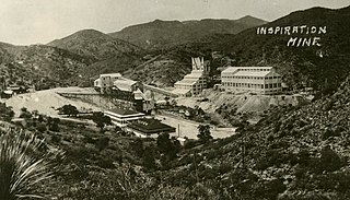
Inspiration is a ghost town in Gila County, Arizona, in the United States. It has an estimated elevation of 3,927 feet (1,197 m) above sea level. Inspiration was the company town for the Inspiration mine.
Polaris, is now a ghost town in the northern part of Yuma County, Arizona, in the Kofa Mountains.
Norton's Landing or Norton's, was a steamboat landing on the Colorado River, in what was then Yuma County, Arizona Territory. Today it is in La Paz County, Arizona. Nortons Landing is 52 miles upriver from Yuma, Arizona 4 miles above Picacho, California and 18 miles below the Clip, Arizona landing. It lies on a rocky point of land next to the river at 215 feet of elevation just east of Red Cloud Wash and Black Rock Wash, where roads to the district mines in the mountains met the Colorado River.
Constellation is a former mining town in Yavapai County, Arizona, United States. It has an estimated elevation of 3,560 feet (1,090 m) above sea level. The town was started to support the Monte Cristo Mine, which was later joined by several other mines. In 1925 the town had a post office and some 250 residents, but no trace of it is left, though ruins of the various mines surround the ghost town site.
Hecla is a former way station situated in Yavapai County, Arizona, United States. Its name is derived from the nearby Hecla mine. It is also known as Stone Corral. Hecla has an estimated elevation of 4,596 feet (1,401 m) above sea level.
Laguna is a populated place situated in Yuma County, Arizona, United States. It is one of two places in Arizona with this name, the other being located in Pinal County. It has an estimated elevation of 1,608 feet (490 m) above sea level.
Ligurta is a populated place situated in Yuma County, Arizona, United States. It has an estimated elevation of 233 feet (71 m) above sea level. It is located in the Dome Valley south of the Gila River. Established as a railroad station on the Sunset Route circa 1880,
Lone Star is a populated place situated in Graham County, Arizona, United States. It has an estimated elevation of 2,953 feet (900 m) above sea level. Eight miles north of Solomonville, the community was named after the nearby mine and mountain.
Stoval is a populated place situated in Yuma County, Arizona, United States, located approximately 70 miles east of Yuma. Originally established as a stagecoach stop in 1869, named Grinnell Station after its first station master Henry Grinnell, it later served as a railroad station on the Southern Pacific Railroad's Sunset Route. Circa 1875 the name was changed to Texas Hill, after a group of emigrants from Texas who were supposedly killed in the area. In 1882–83, Oscar F. Thornton emigrated from California and established a farming community near the station. Due to the fertility of the farmland, he named his community Christvale. Thornton became the first postmaster of the Christvale post office when it was established on September 25, 1888. Railroad personnel did not like the name, however, and shortened it to Chrystoval. With the advent of the telegraph, the name was further shortened to its present-day Stoval in approximately 1911, in order to save on telegraphing. After closing down at some point, the post office was re-established on May 21, 1914, under the name of Stoval. It has an estimated elevation of 400 feet (120 m) above sea level.
Sundad is an unincorporated area in the far west of Maricopa County, Arizona, United States, along the border of Yuma County. It has an estimated elevation of 965 feet (294 m) above sea level. It is located north of Agua Caliente and east of Sacation Flats.

Youngberg is a populated place situated in Pinal County, Arizona, United States.

Camp Hyder was a US Army installation in Arizona, functioning as a subcamp of the Desert Training Center in Riverside County, California. The main headquarters for the Desert Training Center was Camp Young, this is where General Patton's 3rd Armored Division was stationed. Camp Hyder is 2 miles (3.2 km) miles south of Hyder, Arizona. The camp was just north of the Gila River. Camp Hyder is 60 miles (97 km) miles east of Yuma, Arizona, near Camp Horn. Camp Hyder was built at the site of an old 1890s military base. Trained at Camp Hyder, in 1943, for six months was the 77th Infantry Division from April 1943 to September 1943. Then the 104th Infantry Division moved in for training. Unlike the other camps, no large tank activity was done. The camp was built by The 369th Engineer Regiment. Camp Hyder had its own rail station at which most troops arrived. The train station at Sentinel, Arizona south of the camp was also used. Over 13,000 troops were trained at Camp Horn and Camp Hyder.


