Vishnu Temple is a 7,533-foot-elevation (2,296-meter) summit located in the Grand Canyon, in Coconino County of Arizona, US.

Wotans Throne is a 7,721-foot-elevation (2,353-meter) summit located in the Grand Canyon, in Coconino County, Arizona, US. It is situated one mile immediately southwest of the Cape Royal overlook on the canyon's North Rim, 1.7 miles west-southwest of Freya Castle, two miles west-northwest of Vishnu Temple, and five miles east of Zoroaster Temple. It rises 5,200 feet above the Colorado River.

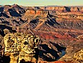
Shiva Temple is a 7,646-foot-elevation (2,331-meter) summit located in the Grand Canyon, in Coconino County of Arizona, US. It is situated six miles north of Hopi Point overlook of the canyon's South Rim, about 2.5 miles southwest of North Rim's Tiyo Point, and two miles northwest of Isis Temple, where it towers 5,200 feet above the Colorado River. Shiva Temple is named for Shiva, the Hindu deity, destroyer of the universe. This name was applied by Clarence Dutton who began the tradition of naming geographical features in the Grand Canyon after mythological deities. Dutton believed Shiva Temple was the largest, grandest, and most majestic of the Grand Canyon buttes, with a broad, level, forested top. This mountain's name was officially adopted in 1906 by the U.S. Board on Geographic Names.

Tower of Set is a 6,012-foot-elevation (1,832-meter) summit located in the Grand Canyon, in Coconino County of Arizona, US. This butte is situated four miles north of Hopi Point overlook on the canyon's South Rim, two miles southeast of Tower of Ra, and three miles south-southwest of Shiva Temple, where it towers 3,600 feet above the Colorado River. Tower of Set was originally named Temple of Sett in 1879 by Thomas Moran, for the Egyptian deity of war, Set, because a niche worn into its wall evoked temples in the valley of the Nile. Another source states it was named by George Wharton James, in keeping with Clarence Dutton's tradition of naming geographical features in the Grand Canyon after mythological deities. This mountain's name was officially adopted in 1906 by the U.S. Board on Geographic Names. In 1919, Harriet Williams Russell Strong proposed connecting Hopi Point and Tower of Set across the river via an aerial tramway, an idea that never came to fruition. The first ascent was made in November 1977 by Bruce Grubbs and Jim Haggart. According to the Köppen climate classification system, Tower of Set is located in a cold semi-arid climate zone.
Angels Gate is a 6,761-foot (2,061 m)-elevation summit located in the Grand Canyon, in Coconino County of Arizona, United States. It is situated seven miles (11 km) due north of the Grandview Point overlook on the canyon's South Rim, three miles (4.8 km) west of Vishnu Temple, and three point five miles (5.6 km) southeast of Zoroaster Temple. Topographic relief is significant as it rises over 4,200 feet (1,300 m) above the Colorado River in three miles. Angels Gate is the place in Paiute mythology where the gods would return to Earth by descending from the shadow world above.

Buddha Temple is a 7,212-foot-elevation (2,198-meter) summit located in the Grand Canyon, in Coconino County of northern Arizona, in the Southwestern United States. It is situated 6.5 miles (10.5 km) due north of the Mather Point overlook on the canyon's South Rim, and four miles southwest of the North Rim's Bright Angel Point. Topographic relief is significant as it rises over 3,800 feet in two miles above Bright Angel Canyon to the east, and 3,000 feet in less than one mile above Haunted Canyon to the immediate west. Its neighbors include Manu Temple 1.5 miles (2.4 km) to the northeast, Isis Temple 2.3 miles to the southwest, Zoroaster Temple 3.8 miles to the southeast, and Deva Temple, 3.5 miles to the east. Buddha Temple was named by Henry Gannett, a geographer for Clarence Dutton, in following Dutton's practice of naming features in the Grand Canyon after mythological deities, in this case Buddha. This geographical feature's name was officially adopted in 1906 by the U.S. Board on Geographic Names. The first ascent of this butte was made in 1973 by Bruce Grubbs, Chauncey Parker, and Mark Brown via the Northwest Arete. According to the Köppen climate classification system, Buddha Temple is located in a Cold semi-arid climate zone.

Deva Temple is a 7,353-foot-elevation (2,241-meter) summit located in the Grand Canyon, in Coconino County of northern Arizona, USA. It is situated three miles south of the North Rim's Bright Angel Point, and towers 3,700 feet above Bright Angel Canyon. Its nearest higher neighbor is Brahma Temple, 1.5 mile to the south. Other neighbors include Zoroaster Temple 2.5 miles to the south-southwest, Manu Temple three miles to the west-northwest, and Buddha Temple, 3.5 miles to the west. Deva Temple was named by Henry Gannett, a geographer for Clarence Dutton, in following Dutton's practice of naming features in the Grand Canyon after mythological deities, in this case, Deva. This geographical feature's name was officially adopted in 1906 by the U.S. Board on Geographic Names. According to the Köppen climate classification system, Deva Temple is located in a Cold semi-arid climate zone.

Explorers Monument is a 4,572-foot-elevation (1,394-meter) summit located in the Grand Canyon, in Coconino County of northern Arizona, US. It is situated 3.5 miles due west of Mount Huethawali, within a meander of the Colorado River. It towers over 2,400 feet directly above the river, providing rafters a view of this landmark. Explorers Monument is topped by rock of the Pennsylvanian-Permian Supai Group which overlays cliff-forming Mississippian Redwall Limestone, which in turn overlays Cambrian Tonto Group. According to the Köppen climate classification system, Explorers Monument is located in a cold semi-arid climate zone.

Chuar Butte is a prominent 6,500-foot-elevation (2,000-meter) summit located in the Grand Canyon, in Coconino County of northern Arizona, US. It is situated 1.5 miles northwest of Cape Solitude on the canyon's East Rim, three miles southeast of Gunther Castle, and immediately west of the confluence of the Colorado River and Little Colorado River. This position also places it where Marble Canyon ends, and the Grand Canyon begins. Topographic relief is significant as it rises nearly 3,800 feet above the river in less than one mile. According to the Köppen climate classification system, Chuar Butte is located in a cold semi-arid climate zone.

Gunther Castle is a 7,199-foot-elevation (2,194-meter) summit located in the Grand Canyon, in Coconino County of northern Arizona, US. It is situated three miles northwest of Chuar Butte, between Kwagunt Valley to the north, and Chuar Valley to the south. Topographic relief is significant as it rises nearly 4,500 feet above the Colorado River in three miles.

Confucius Temple is a 7,081-foot-elevation (2,158-meter) summit located in the Grand Canyon, in Coconino County of northern Arizona, US. It is situated 1.5 mile southeast of Point Sublime, four miles west-northwest of Shiva Temple, and three miles northwest of Tower of Ra, where it rises over 3,200 feet above Hindu Amphitheater. Confucius Temple is named for Confucius, the Chinese philosopher. This name was applied by Clarence Dutton, who began the tradition of naming geographical features in the Grand Canyon after mythological deities. Confucius Temple is one of the Twin Buttes in the Grand Canyon, the other being Mencius Temple (7,001 ft), which is named for Mencius, considered the second-most famous sage, after only Confucius himself. This mountain's name was officially adopted in 1906 by the U.S. Board on Geographic Names. According to the Köppen climate classification system, Confucius Temple has a Cold semi-arid climate.

Freya Castle is a 7,288-foot-elevation (2,221-meter) summit located in the Grand Canyon, in Coconino County of northern Arizona, US. It is situated one mile southeast of the Cape Royal overlook on the canyon's North Rim, 1.5 mile north of Vishnu Temple, and 1.7 mile northeast of Wotans Throne. Topographic relief is significant as it rises 3,400 feet above the Unkar Valley in one mile.

Jupiter Temple is a 7,084-foot (2,159 m)-elevation summit located in the Grand Canyon, in Coconino County of northern Arizona, United States. It is situated one mile (1.6 km) southeast of Cape Final on the canyon's North Rim, one point five miles (2.4 km) north-northwest of Apollo Temple, and three miles (4.8 km) northeast of Freya Castle, which is the nearest higher peak. Topographic relief is significant as it rises 4,400 feet (1,300 m) above the Colorado River in less than four miles (6.4 km).

Pollux Temple is a 6,251-foot-elevation (1,905-meter) summit in the Grand Canyon, in Coconino County of northern Arizona, US. It is situated ten miles northwest of Grand Canyon Village, and less than one mile northeast of Jicarilla Point. Castor Temple is one mile northwest, and Diana Temple is one mile southeast. Topographic relief is significant as Pollux Temple rises nearly 4,000 feet above the Colorado River in less than two miles. Pollux Temple is named for Pollux, the divine son of Zeus according to Greek mythology. Clarence Dutton began the practice of naming geographical features in the Grand Canyon after mythological deities. According to the Köppen climate classification system, Pollux Temple is located in a Cold semi-arid climate zone.

Diana Temple is a 6,683-foot-elevation (2,037-meter) summit located in the Grand Canyon, in Coconino County of northern Arizona, US. It is situated nine miles northwest of Grand Canyon Village, and immediately northeast of Mescalero Point. Pollux Temple is one mile northwest, Marsh Butte one mile east-northeast, and Vesta Temple is one mile south. Topographic relief is significant as Diana Temple rises nearly 4,300 feet above the Colorado River in less than two miles. Diana Temple is named for Diana, the goddess of the hunt and the moon according to Roman mythology. Clarence Dutton began the practice of naming geographical features in the Grand Canyon after mythological deities. The U.S. Geological Survey applied the name, and this geographical feature's name was officially adopted in 1908 by the U.S. Board on Geographic Names. In the early 1900s this mesa was sometimes called "No Mans Land". According to the Köppen climate classification system, Diana Temple is located in a Cold semi-arid climate zone.

Marsh Butte is a 4,721-foot-elevation (1,439-meter) summit located in the Grand Canyon, in Coconino County in the northern part of the U.S. state of Arizona. It is situated eight miles northwest of Grand Canyon Village, immediately east-northeast of Diana Temple, and Tower of Ra stands directly opposite across Granite Gorge. Topographic relief is significant, as Marsh Butte rises over 2,300 feet above the Colorado River in half a mile (1 km).

Newberry Butte is a 5,105-foot-elevation (1,556-meter) summit located in the Grand Canyon, in Coconino County of northern Arizona, US. It is situated 4.5 miles north of the South Rim's Grandview Point, three miles southwest of Vishnu Temple, and 2.5 miles south of Wotans Throne. Topographic relief is significant as it rises over 2,500 feet above the Colorado River and Granite Gorge in one mile. According to the Köppen climate classification system, Newberry Butte is located in a Cold semi-arid climate zone.

Solomon Temple is a 5,121-foot-elevation (1,561-meter) summit located in the Grand Canyon, in Coconino County of northern Arizona, USA. It is situated four miles north of Moran Point, 3.5 miles east of Newberry Butte, and 1.5 mile southeast of Rama Shrine, its nearest higher neighbor. Topographic relief is significant as it rises 2,500 feet above the Colorado River in less than one mile.

Butchart Butte is a 7,602-foot (2,317 m)-elevation summit located in the Grand Canyon, in Coconino County of northern Arizona, United States. It is situated on the North Rim, midway between Gunther Castle and Siegfried Pyre, and between the Chuar and Kwagunt Valleys. Topographic relief is significant as it rises 4,900 feet (1,500 m) above the Colorado River in five miles.

Vesta Temple is a 6,299-foot-elevation (1,920-meter) summit located in the Grand Canyon, in Coconino County of northern Arizona, US. It is situated eight miles west-northwest of Grand Canyon Village, and immediately northeast of Mimbreno Point. Marsh Butte is one mile northeast, Eremita Mesa immediately southeast, and nearest higher neighbor Diana Temple is one mile north. Topographic relief is significant as Vesta Temple rises 3,900 feet above the Colorado River in 2.5 miles. Vesta Temple is named for Vesta, the goddess of the hearth, home, and family according to Roman mythology. Clarence Dutton began the practice of naming geographical features in the Grand Canyon after mythological deities. This geographical feature's toponym was officially adopted in 1908 by the U.S. Board on Geographic Names. According to the Köppen climate classification system, Vesta Temple is located in a Cold semi-arid climate zone.