
Grand Canyon National Park, located in northwestern Arizona, is the 15th site in the United States to have been named as a national park. The park's central feature is the Grand Canyon, a gorge of the Colorado River, which is often considered one of the Wonders of the World. The park, which covers 1,217,262 acres of unincorporated area in Coconino and Mohave counties, received more than 4.7 million recreational visitors in 2022, which is the second highest count of all American national parks after Great Smoky Mountains National Park. The Grand Canyon was designated a World Heritage Site by UNESCO in 1979. The park celebrated its 100th anniversary on February 26, 2019.

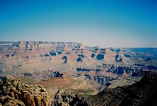
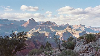
The Grand Canyon is a steep-sided canyon carved by the Colorado River in Arizona, United States. The Grand Canyon is 277 miles (446 km) long, up to 18 miles (29 km) wide and attains a depth of over a mile.

Colorado National Monument is a National Park Service unit near the city of Grand Junction, Colorado. Sheer-walled canyons cut deep into sandstone and granite–gneiss–schist rock formations. This is an area of desert land high on the Colorado Plateau, with pinyon and juniper forests on the plateau. The park hosts a wide range of wildlife, including red-tailed hawks, golden eagles, ravens, jays, desert bighorn sheep, and coyotes. Activities include hiking, horseback riding, road bicycling, and scenic drives; a visitor center on the west side contains a natural history museum and gift shop. There are scenic views from trails, Rim Rock Drive, which winds along the plateau, and the campground. Nearby are the Book Cliffs and the largest flat-topped mountain in the world, the Grand Mesa.

The Bright Angel Trail is a hiking trail located in Grand Canyon National Park in the U.S. state of Arizona.

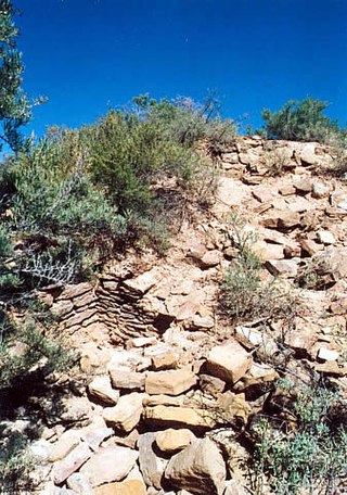
The known human history of the Grand Canyon area stretches back 10,500 years, when the first evidence of human presence in the area is found. Native Americans have inhabited the Grand Canyon and the area now covered by Grand Canyon National Park for at least the last 4,000 of those years. Ancestral Pueblo peoples, first as the Basketmaker culture and later as the more familiar Pueblo people, developed from the Desert Culture as they became less nomadic and more dependent on agriculture. A similar culture, the Cochimi also lived in the canyon area. Drought in the late 13th century likely caused both groups to move on. Other people followed, including the Paiute, Cerbat, and the Navajo, only to be later forced onto reservations by the United States Government.
Yucca House National Monument is a United States National Monument located in Montezuma County, Colorado between the towns of Towaoc and Cortez, Colorado. Yucca House is a large, unexcavated Ancestral Puebloan archaeological site.

Phantom Ranch is a lodge inside Grand Canyon National Park in Arizona. It sits at the bottom of Grand Canyon, on the east side of Bright Angel Creek, a little over half a mile north of the Creek's confluence with the Colorado River. Opened in 1922, Phantom Ranch is a member of Historic Hotels of America, the official program of the National Trust for Historic Preservation.

The Tonto Trail is a hiking trail on the South Rim of the Grand Canyon in Grand Canyon National Park, located in the U.S. state of Arizona.
The Grandview Trail is a hiking trail located on the South Rim of the Grand Canyon National Park, located in the U.S. state of Arizona.It was built in 1893 by miners and is noted for its cobblestone and cribbing sections.

John Harvey Butchart was a mathematics professor who was well known for his hiking exploits in and around the Grand Canyon in Arizona, United States. Beginning in 1945, Butchart explored the Grand Canyon's backcountry on foot. He wrote extensively about his adventures and influenced generations of canyoneers.
The New Hance Trail is a hiking trail on the South Rim of the Grand Canyon National Park, located in the U.S. state of Arizona. It is one of the "unmaintained" trails and, along with the similar Tanner Trail, is considered one of the most difficult trails on the South Rim. Unlike the Tanner Trail, there is no parking available at the trailhead, which is located about a 5-minute walk north of the South Rim main road. The trail ends at the Hance Rapids on the Colorado River. It is approximately 6.5 hiking miles and a 4400' descent from the South Rim main road at ~7040' to the Colorado River at ~2600' elevation.

The Escalante Route is a hiking trail on the South Rim of the Grand Canyon National Park, located in the U.S. state of Arizona. It starts near the Tanner Rapids on the Colorado River and follows the river. It also passes by Escalante Creek and ends near the Hance Rapids. It falls into the lowest maintenance category ("route") of the Grand Canyon trails which means it is essentially unmaintained. There is a 30-feet cliff located near the Hance Rapids, popularly known as the Papago Wall, which needs to be climbed. The National Park Service advises to bring a rope for backpacks. There are several other easy, yet avoidable climbing opportunities in 75 Mile Canyon, some of which have been marked by cairns.

The Grand Canyon mid-air collision occurred in the western United States on June 30, 1956, when a United Airlines Douglas DC-7 struck a Trans World Airlines Lockheed L-1049 Super Constellation over Grand Canyon National Park, Arizona. The first one fell into a canyon and the other one slammed into a rock face. All 128 on board both airplanes perished, making it the first commercial airline incident to exceed one hundred fatalities. The airplanes had departed Los Angeles International Airport minutes apart from each other and headed for Chicago and Kansas City, respectively. The collision took place in uncontrolled airspace, where it was the pilots' responsibility to maintain separation. This highlighted the antiquated state of air traffic control, which became the focus of major aviation reforms.

Grand Canyon Conservancy, formerly known as Grand Canyon Association, is the National Park Service's official non-profit partner of Grand Canyon National Park, raising private funds, operating retail shops within the park, and providing premier guided educational programs about the natural and cultural history of the region. Supporters fund projects including trails and historic building preservation, educational programs for the public, and the protection of wildlife and their natural habitat.
Louis Boucher was a Canadian-born American prospector, miner, explorer, and guide in the Grand Canyon, Arizona in the late 19th to early 20th century.

The Hakatai Shale is a Mesoproterozoic rock formation with important exposures in the Grand Canyon, Coconino County, Arizona. It consists of colorful strata that exhibit colors varying from purple to red to brilliant orange. These colors are the result of the oxidation of iron-bearing minerals in the Hakatai Shale. It consists of lower and middle members that consist of bright-red, slope-forming, highly fractured, argillaceous mudstones and shale and an upper member composed of purple and red, cliff-forming, medium-grained sandstone. Its thickness, which apparently increases eastwards, varies from 137 to 300 m. In general, the Hakatai Shale and associated strata of the Unkar Group rocks dip northeast (10–30°) toward normal faults that dip 60° or more toward the southwest. This can be seen at the Palisades fault in the eastern part of the main Unkar Group outcrop area. In addition, thick, prominent, and dark-colored basaltic sills and dikes cut across the purple to red to brilliant orange strata of the Hakatai Shale.

The Bass Formation, also known as the Bass Limestone, is a Mesoproterozoic rock formation that outcrops in the eastern Grand Canyon, Coconino County, Arizona. The Bass Formation erodes as either cliffs or stair-stepped cliffs. In the case of the stair-stepped topography, resistant dolomite layers form risers and argillite layers form steep treads. In general, the Bass Formation in the Grand Canyon region and associated strata of the Unkar Group-rocks dip northeast (10°–30°) toward normal faults that dip 60+° toward the southwest. This can be seen at the Palisades fault in the eastern part of the main Unkar Group outcrop area. In addition, thick, prominent, and dark-colored basaltic sills intrude across the Bass Formation.

Grand Canyon Pioneer Cemetery, also known as Pioneer Cemetery, is a historic cemetery located near the Grand Canyon's South Rim. It is also known as South Rim Cemetery and the American Legion Cemetery due to its association with the veterans' organization.
