Uinkaret volcanic field

Last updated
Uinkaret volcanic field
Uinkaret TheExpanseOfTime NASA172332.jpg
Highest point
Elevation 1,555 m (5,102 ft) [1]
Coordinates 36°23′N113°08′W / 36.38°N 113.13°W / 36.38; -113.13
Geography
Location Mohave County, Arizona, US
Topo map USGS Mount Logan
Geology
Age of rock 1.2 million years [2]
Mountain type volcanic field
Last eruption 1100 ± 75 years
Basalts from the Uinkaret volcanic field flow into the Grand Canyon from its North Rim. On the right is Lava Falls, with Vulcan's Throne at the top, half visible along the right-hand edge of the photo. Vulcan's Throne is about 73,000 years old. These are among the most recent features of the Grand Canyon. The topmost layers over which the lava flowed, the Kaibab Limestone, was deposited in Early Permian time, around 290 million years ago. VulcanUinkart.jpg
Basalts from the Uinkaret volcanic field flow into the Grand Canyon from its North Rim. On the right is Lava Falls, with Vulcan's Throne at the top, half visible along the right-hand edge of the photo. Vulcan's Throne is about 73,000 years old. These are among the most recent features of the Grand Canyon. The topmost layers over which the lava flowed, the Kaibab Limestone, was deposited in Early Permian time, around 290 million years ago.
Vulcan's Throne (top right) and Lava Falls, 2008 aerial photo Lava Falls, where the Uinkaret Volcanic Field pours into the Grand Canyon.jpg
Vulcan's Throne (top right) and Lava Falls, 2008 aerial photo

The Uinkaret volcanic field is an area of monogenetic volcanoes in northwestern Arizona, United States, located on the north rim of the Grand Canyon. [2]

Contents

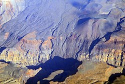
Lava flows from the Uinkaret volcanic field that have cascaded down into the Grand Canyon, damming the Colorado River, have been used to date the canyon's carving. [3] One of these cascades is today's Lava Falls. Lava Falls Rapid, below Lava Falls on the Colorado River, is "at all water levels, the most severe rapid in Grand Canyon." [4]

The Colorado River was dammed by lava flows multiple times from 725,000 to 100,000 years ago. [5] While some believe that these lava dams were stable, lasting up to 20,000 years and forming large reservoirs, [6] others think they failed quickly and catastrophically as massive floods. [7] Lava flows traveled downriver 76 miles (121 km) from river mile 178 to 254.[ citation needed ]

One lava flow, from Little Springs, south of Pliocene Mount Trumbull, has a cosmogenic helium age of 1300 +/- 500 years BP. Pottery shards dated to between 1050 and 1200  CE were found within the lava flow, produced around the same time as the Sunset Crater eruption in the San Francisco volcanic field on the South Rim. [1]

Notable Vents

NameElevationLocationLast eruption
metersfeet Coordinates
Mount Emma [8] ----
Little Springs [8] ---1050-1200 AD
Prospect Cone [8] ----
Mount Trumbull [8] ----
Vulcan's Forge [2] ----
Vulcan's Throne [1] [2] ---73,000 years ago

See also

Related Research Articles

<span class="mw-page-title-main">Belknap Crater</span> Shield volcano in the U.S. state of Oregon

Belknap Crater is a shield volcano in the Cascade Range in the U.S. state of Oregon. Located in Linn County, it is associated with lava fields and numerous subfeatures including the Little Belknap and South Belknap volcanic cones. It lies north of McKenzie Pass and forms part of the Mount Washington Wilderness. Belknap is not forested and most of its lava flows are not vegetated, though there is some wildlife in the area around the volcano, as well as a number of tree molds formed by its eruptive activity.

<span class="mw-page-title-main">Geology of the Grand Canyon area</span> Aspect of geology

The geology of the Grand Canyon area includes one of the most complete and studied sequences of rock on Earth. The nearly 40 major sedimentary rock layers exposed in the Grand Canyon and in the Grand Canyon National Park area range in age from about 200 million to nearly 2 billion years old. Most were deposited in warm, shallow seas and near ancient, long-gone sea shores in western North America. Both marine and terrestrial sediments are represented, including lithified sand dunes from an extinct desert. There are at least 14 known unconformities in the geologic record found in the Grand Canyon.

<span class="mw-page-title-main">Garibaldi Volcanic Belt</span> Volcanic chain in southwestern British Columbia, Canada

The Garibaldi Volcanic Belt is a northwest–southeast trending volcanic chain in the Pacific Ranges of the Coast Mountains that extends from Watts Point in the south to the Ha-Iltzuk Icefield in the north. This chain of volcanoes is located in southwestern British Columbia, Canada. It forms the northernmost segment of the Cascade Volcanic Arc, which includes Mount St. Helens and Mount Baker. Most volcanoes of the Garibaldi chain are dormant stratovolcanoes and subglacial volcanoes that have been eroded by glacial ice. Less common volcanic landforms include cinder cones, volcanic plugs, lava domes and calderas. These diverse formations were created by different styles of volcanic activity, including Peléan and Plinian eruptions.

<span class="mw-page-title-main">Yellowstone hotspot</span> Volcanic hotspot in the United States

The Yellowstone hotspot is a volcanic hotspot in the United States responsible for large scale volcanism in Idaho, Montana, Nevada, Oregon, and Wyoming, formed as the North American tectonic plate moved over it. It formed the eastern Snake River Plain through a succession of caldera-forming eruptions. The resulting calderas include the Island Park Caldera, Henry's Fork Caldera, and the Bruneau-Jarbidge caldera. The hotspot currently lies under the Yellowstone Caldera. The hotspot's most recent caldera-forming supereruption, known as the Lava Creek Eruption, took place 640,000 years ago and created the Lava Creek Tuff, and the most recent Yellowstone Caldera. The Yellowstone hotspot is one of a few volcanic hotspots underlying the North American tectonic plate; another example is the Anahim hotspot.

<span class="mw-page-title-main">Mount Price (British Columbia)</span> Stratovolcano in British Columbia, Canada

Mount Price is a small stratovolcano in the Garibaldi Ranges of the Pacific Ranges in southwestern British Columbia, Canada. It has an elevation of 2,049 metres and rises above the surrounding landscape on the western side of Garibaldi Lake in New Westminster Land District. The mountain contains a number of subfeatures, including Clinker Peak on its western flank, which was the source of two thick lava flows between 15,000 and 8,000 years ago that ponded against glacial ice. These lava flows are structurally unstable, having produced large landslides as recently as the 1850s. A large provincial park surrounds Mount Price and other volcanoes in its vicinity. It lies within an ecological region that surrounds much of the Pacific Ranges.

<span class="mw-page-title-main">Mount Trumbull Wilderness</span> Protected area in Mohave County, Arizona

The Mount Trumbull Wilderness is a 7,880 acre (31 km2) wilderness area located on the Uinkaret Plateau in the Arizona Strip. It is managed by the Bureau of Land Management.

<span class="mw-page-title-main">Dotsero</span> Volcano in Colorado, United States

Dotsero Crater is an elongate, 2,300 ft (700 m) long by 1,300 ft (400 m) wide, maar incised into sedimentary strata of the side of a mountain, called Blowout Hill, and local, irregular, mountainous topography. At an elevation of 7,316 ft (2,230 m), its north rim lies about 330 ft (100 m) higher than its south rim. Dotsero Crater is about 1,300 ft (400 m) deep. It is part of a maar and scoria cone complex in which the associated scoria cones are constructed along a NNE-SSW line on either side of the maar and is perched near the upper edge of steep sided canyons about 1,000 ft (300 m) above the valley floor of the Eagle River. The axis of the maar and scoria cone complex aligns with the axis of a local syncline. Associated with the maar and scoria cones is a lahar and 2 mi (3.2 km)-long lava flow. Dotsero Crater lies northeast of Dotsero, Colorado near the junction of the Colorado River and the Eagle River.

<span class="mw-page-title-main">Cascade Volcanoes</span> Chain of stratovolcanoes in western North America

The Cascade Volcanoes are a number of volcanoes in a volcanic arc in western North America, extending from southwestern British Columbia through Washington and Oregon to Northern California, a distance of well over 700 miles (1,100 km). The arc formed due to subduction along the Cascadia subduction zone. Although taking its name from the Cascade Range, this term is a geologic grouping rather than a geographic one, and the Cascade Volcanoes extend north into the Coast Mountains, past the Fraser River which is the northward limit of the Cascade Range proper.

<span class="mw-page-title-main">Geology of the Pacific Northwest</span>

The geology of the Pacific Northwest includes the composition, structure, physical properties and the processes that shape the Pacific Northwest region of North America. The region is part of the Ring of Fire: the subduction of the Pacific and Farallon Plates under the North American Plate is responsible for many of the area's scenic features as well as some of its hazards, such as volcanoes, earthquakes, and landslides.

<span class="mw-page-title-main">Vulcan's Throne</span> Landform in the Grand Canyon, Arizona

Vulcan's Throne is a cinder cone volcano and a prominent landmark on the North Rim of the Grand Canyon in Arizona, United States. The volcano is adjacent the Colorado River, as it is the source material for Lava Falls and Lava Falls Rapids one of the largest rapids of the Colorado. Vulcan's Throne, about a mile (1.7 km) west of Toroweap overlook, is part of the Uinkaret volcanic field. The journals of traveler George Corning Fraser record a trip to the summit of Vulcan's Throne in 1914. At the time, the surrounding area was used for sheep grazing, and a small reservoir had been constructed at the base of the volcano. Fraser wrote that

Vulcan's Throne is a pure cinder cone covered with scoriae, cinders, clinkers and peperino lying loose on the surface, with a slope, as near as I could measure, from 28° to 31°. A little sage, many cacti and perhaps some other similar low plants grow on it, but otherwise nothing. Climbing it was like ascending a sand-dune. Every step forward involved slipping half way back and boots were soon filled with painful bits of stone.

<span class="mw-page-title-main">Tuckup Trail</span> Grand Canyon hiking trail

The Tuckup Trail is a 100-mile-long (160 km) hiking trail on the North Rim of the Grand Canyon, in Grand Canyon National Park, located in the U.S. state of Arizona.

<span class="mw-page-title-main">Volcanic dam</span> Natural dam produced directly or indirectly by volcanism

A volcanic dam is a type of natural dam produced directly or indirectly by volcanism, which holds or temporarily restricts the flow of surface water in existing streams, like a man-made dam. There are two main types of volcanic dams, those created by the flow of molten lava, and those created by the primary or secondary deposition of pyroclastic material and debris. This classification generally excludes other, often larger and longer lived dam-type geologic features, separately termed crater lakes, although these volcanic centers may be associated with the source of material for volcanic dams, and the lowest portion of its confining rim may be considered as such a dam, especially if the lake level within the crater is relatively high.

<span class="mw-page-title-main">Volcanic history of the Northern Cordilleran Volcanic Province</span>

The volcanic history of the Northern Cordilleran Volcanic Province presents a record of volcanic activity in northwestern British Columbia, central Yukon and the U.S. state of easternmost Alaska. The volcanic activity lies in the northern part of the Western Cordillera of the Pacific Northwest region of North America. Extensional cracking of the North American Plate in this part of North America has existed for millions of years. Continuation of this continental rifting has fed scores of volcanoes throughout the Northern Cordilleran Volcanic Province over at least the past 20 million years and occasionally continued into geologically recent times.

<span class="mw-page-title-main">Canadian Cascade Arc</span> Canadian segment of the North American Cascade Volcanic Arc

The Canadian Cascade Arc, also called the Canadian Cascades, is the Canadian segment of the North American Cascade Volcanic Arc. Located entirely within the Canadian province of British Columbia, it extends from the Cascade Mountains in the south to the Coast Mountains in the north. Specifically, the southern end of the Canadian Cascades begin at the Canada–United States border. However, the specific boundaries of the northern end are not precisely known and the geology in this part of the volcanic arc is poorly understood. It is widely accepted by geologists that the Canadian Cascade Arc extends through the Pacific Ranges of the Coast Mountains. However, others have expressed concern that the volcanic arc possibly extends further north into the Kitimat Ranges, another subdivision of the Coast Mountains, and even as far north as Haida Gwaii.

<span class="mw-page-title-main">Bridge River Vent</span> Volcanic crater in Canada

The Bridge River Vent is a volcanic crater in the Pacific Ranges of the Coast Mountains in southwestern British Columbia, Canada. It is located 51 km (32 mi) west of Bralorne on the northeastern flank of the Mount Meager massif. With an elevation of 1,524 m (5,000 ft), it lies on the steep northern face of Plinth Peak, a 2,677 m (8,783 ft) high volcanic peak comprising the northern portion of Meager. The vent rises above the western shoulder of the Pemberton Valley and represents the northernmost volcanic feature of the Mount Meager massif.

<span class="mw-page-title-main">Cardenas Basalt</span> Rock formation in the Grand Canyon, Arizona

The Cardenas Basalt, also known as either the Cardenas Lava or Cardenas Lavas, is a rock formation that outcrops over an area of about 310 km2 (120 mi2) in the eastern Grand Canyon, Coconino County, Arizona. The lower part of the Cardenas Basalt forms granular talus slopes. Its upper part forms nearly continuous low cliffs that are parallel to the general course of the Colorado River. The most complete, readily accessible, and easily studied exposure of the Cardenas Basalt lies in Basalt Canyon. This is also its type locality.

<span class="mw-page-title-main">Toroweap Fault</span> Geologic feature in the Grand Canyon, Arizona

The Toroweap Fault of northwest Arizona and southwest Utah is part of a fault system of the west Grand Canyon region, Arizona, US; also the west perimeter regions of the Coconino and Colorado Plateaus. The Hurricane Fault originates at the Toroweap Fault, in the region of the Colorado River, and strikes as the westerly depression of the Toroweap Fault. The Toroweap strikes northerly from the Colorado at the east of Toroweap Valley, and enters south Utah; from the Colorado River, the Hurricane Fault strikes north-northwest along the west flank of the small, regional Uinkaret Mountains, the west border of Toroweap Valley. The Hurricane Fault, and the Hurricane Cliffs strike into southwest Utah as part of the west, and southwest perimeter of the Colorado Plateau. The Hurricane Cliffs are made of Kaibab Limestone, an erosion resistant, cliff-forming rock unit.

<span class="mw-page-title-main">Esplanade Sandstone</span> Geologic unit found in the Grand Canyon

The Lower Permian Esplanade Sandstone is a cliff-forming, resistant sandstone, dark red, geologic unit found in the Grand Canyon. The rock unit forms a resistant shelf in the west Grand Canyon, south side of the Colorado River, at the east of the Toroweap Fault, down-dropped to west, southeast of Toroweap Overlook, and west of Havasupai. The red, sandstone shelf, The Esplanade is about 20-mi long. At Toroweap Overlook region, Toroweap Valley with Vulcan's Throne, Uinkaret volcanic field, the resistant Esplanade Sandstone is described in access routes exploring the Toroweap Lake area.

Hyaloclastite Dam was a 1,201 ft (366 m) high lava dam that occupied the Grand Canyon of the U.S. state of Arizona. It formed during the Pleistocene epoch when basaltic lava flows from the Uinkaret volcanic field blocked the Colorado River. The dam failed catastrophically 160,000 years ago to produce the largest known outburst flood on the Colorado River in the Grand Canyon. A slump block of basalt is the remaining remnant of the Hyaloclastite Dam.

<span class="mw-page-title-main">Sand Mountain Volcanic Field</span> Volcanic field in Oregon

The Sand Mountain Volcanic Field is a volcanic field in the upper McKenzie River watershed, located in the United States in Oregon. Part of the Cascade Volcanic Arc, it lies southwest of Mount Jefferson and northwest of Belknap Crater and Mount Washington. Its highest elevation is 5,463 feet (1,665 m).

References

  1. 1 2 3 4 "Uinkaret Field". Global Volcanism Program . Smithsonian Institution.
  2. 1 2 3 4 Wood, Charles A.; Jűrgen Kienle (1993). Volcanoes of North America. Cambridge University Press. pp. 277–278. ISBN   0-521-43811-X.
  3. "Grand Canyon National Park – Geologic Formations (U.S. National Park Service)". U.S. National Park Service. 2007-03-29. Retrieved 2007-05-24.
  4. New Debris Flow at Lava Falls, at Grand Canyon River Guides. Accessed 5/26/09.
  5. Karlstrom, K., Crow, R., Peters, L., McIntosh, W., Raucci, J., Crossey, L., and Umhoefer, P., 2007, 40Ar/39Ar and field studies of Quaternary basalts in Grand Canyon and model for carving Grand Canyon: Quantifying the interaction of river incision and normal faulting across the western edge of the Colorado Plateau: GSA Bulletin, v. 119, no. 11/12, pp. 1283–1312.
  6. Hamblin, W.K., 1994, Late Cenozoic lava dams in the western Grand Canyon: Geological Society of America Memoir 183, 139 p.
  7. Fenton, C.R., Poreda, R.J., Nash, B.P., Webb, R.H., and Cerling, T.E., 2004, Geochemical discrimination of five Pleistocene lava-dam outburst-flood deposits, western Grand Canyon, Arizona: The Journal of Geology, v. 112, pp. 91–110, doi : 10.1086/379694.
  8. 1 2 3 4 "Uinkaret Field: Synonyms and Subfeatures". Global Volcanism Program . Smithsonian Institution . Retrieved 2007-05-23.