Bright Angel Shale

Last updated
Bright Angel Shale
Stratigraphic range: Middle Cambrian
507–502  Ma
O
S
D
C
P
T
J
K
Pg
N
[1]
Grand Canyon-Mather point.jpg
Muav Limestone – (dark or light gray, brown, or orange-red subcliff at base of Redwall Limestone cliff) and Bright Angel Shale (greenish slope-former), resting on Tapeats Sandstone (short, dp brown vertical cliff) (Tapeats forms the "Tonto Platform"), inner canyon, Granite Gorge. (The 3 units Muav, Bright Angel, and Tapeats, are easily seen below the red-stained Redwall Limestone (550 feet (170 m) thick)
Type Geological formation
Unit of Tonto Group [2]
Underlies Muav Limestone
Overlies Tapeats Sandstone
Thickness500 feet (150 m) at its maximum
Lithology
Primarymicaceous siltstone and shale
Other sandstone and glauconitic sandstone
Location
Regionnorthern Arizona, southeast California, southern Nevada, and southcentral Utah
Country United States of America
Type section
Named forBright Angel Canyon, Bright Angel quadrangle, Coconino Co., Arizona [3]
Named byNoble (1914) [3]

The Bright Angel Shale is one of five geological formations that comprise the Cambrian Tonto Group. It and the other formations of the Tonto Group outcrop in the Grand Canyon, Arizona, and parts of northern Arizona, central Arizona, southeast California, southern Nevada, and southeast Utah. The Bright Angel Shale consists of locally fossiliferous, green and red-brown, micaceous, fissile shale (mudstone) and siltstone with local, thicker beds of brown to tan sandstone and limestone. It ranges in thickness from 57 to 450 feet (17 to 137 m). Typically, its thin-bedded shales and sandstones are interbedded in cm-scale cycles. They also exhibit abundant sedimentary structures that include current, oscillation, and interference ripples. The Bright Angel Shale also gradually grades downward into the underlying Tapeats Sandstone. It also complexly interfingers with the overlying Muav Limestone. These characters make the upper and lower contacts of the Bright Angel Shale often difficult to define. Typically, its thin-bedded shales and sandstones erode into green and red-brown slopes that rise from the Tonto Platform up to cliffs formed by limestones of the overlying Muav Limestone and dolomites of the Frenchman Mountain Dolostone. [2] [4]

Contents

Nomenclature

In 1875, G. K. Gilbert [5] recognized that strata exposed near the bottom of parts of the Grand Canyon are similar to those known elsewhere in Arizona as the Tonto Group. Based upon this similarity, he assigned the strata that form the lowermost part of the Phanerozoic strata in the Grand Canyon to the Tonto Group. Without designating formal type localities, he also subdivided the Tonto Group into three subdivisions, from youngest to oldest, the Marbled limestone, the Tonto shale, and the Tonto sandstone. [5]

In 1914, L F. Noble [3] renamed Gilbert's subdivisions of the Tonto Group. He renamed the Tonto sandstone as the Tapeats Sandstone and the Tonto shale as the Bright Angel Shale. He named the Bright Angel Shale after Bright Angel Canyon because in the walls of this canyon, this formation is well exposed. [3]

Later in 1922, [6] the Marbled limestone was redefined and renamed as the Muav Limestone by L. F. Noble. According to Noble's definition, the Muav Limestone consisted of an upper set of dolomite beds and a lower set of limestone beds. [6] Noble's lower set of limestone beds is now defined as the Muav Limestone and the Frenchman Mountain Dolostone is now defined as Noble's upper set of dolomite beds. [4]

E. D. McKee and C. E. Resser [7] largely retained Noble's nomenclature. However, they did subdivide the Bright Angel Shale into a number of subdivisions, members, based upon prominent beds of limestone and sandstone within it. However, these members have found to be confusing and unhelpful in understanding the stratigraphy of the Bright Angel Shale and are typically ignored and rarely used in the published literature. [8] [9]

Description

In the Grand Canyon, the Bright Angel Shale is typically a heterogenous, sometimes fossiliferous, mixture of interbedded shale, mudstone, siltstone, fine-grained sandstone, and isolated beds of limestone. The dominant lithology within the Bright Angel Shale is greenish shale that is composed largely of illite and varying amounts of chlorite and kaolinite. A reddish brown coloration is imparted to a number of the sandstone and siltstone beds by the high percentage of hematitic ooids and iron oxide cements that they contain. Isolated beds of coarse-grained sandstone with either basal conglomerate or conglomeratic sandstone also locally occur within the Bright Angel Shale. The gravel fraction of these beds contain quartz, minor amounts of potassium feldspars, sedimentary rock fragments, and glauconite. Glauconite also occurs in and imparts a greenish color to many of the siltstones and sandstones. Towards its base, the Bright Angel Shale becomes increasingly coarser with increasing frequency of sandstone beds until it grades gradually into the Tapeats Sandstone. [2] [4] [7]

The siltstones and sandstones of the Bright Angel Shale exhibit sedimentary structures throughout the Grand Canyon. These sedimentary structures include horizontal laminations, small- to large-scale planar tabular and trough cross-stratification, and wavy and lenticular bedding. The isolated coarse-grained and conglomeratic sandstones are typically structureless and crudely stratified and overlie a locally scoured surface. [2] [4] [7]

In the Grand Canyon, the Bright Angel Shale is generally about 350 to 500 feet (110 to 150 m) thick. In the western Grand Canyon, the Bright Angel Shale is over 450 feet (140 m) thick and decrease eastward in thickness to only about 270 feet (82 m) at Toroweap in the central canyon. It is 325 feet (99 m) thick in Bright Angel Canyon. The complex interfingering of the Bright Angel Shale with the overlying Muav Limestone is the main cause of the variability in its thickness. South the Grand Canyon, decreases in thickness only a few feet thick in the Juniper Mountains north of Prescott, Arizona. [2] [4] [7]

Fossils

Within the Grand Canyon, the Bright Angel Shale is the most fossiliferous of the five formations that comprise the Tonto Group. It contains a variety of body fossils and is rich in trace fossils. Overall, when compared with other Middle Cambrian formations in the region, the Bright Angel Shale body fossils are fragmentary and rare. Although it is relatively barren regionally of body fossils, individual beds can be rich in complete body fossils. Individual beds within the Bright Angel Shale are as productive as many of the other Cambrian formations in the Great Basin and Rocky Mountain regions. The Bright Angel Shale has yielded at least 15 species of trilobites and four genera of brachiopods. In addition, one genus of hyoliths, four genera of possible marine arthropods, and two species of eocrinoids have been found in it. [10]

The trace fossils found in the Bright Angel Shale consist of arthropod tracks and trails, worm burrows, and dwelling structures. Some of these have been identified at the ichnogenus and ichnospecies level. In addition, wrinkle structures have been found within the Bright Angel Shale in the Sumner Butte area. They are classified as microbially induced sedimentary structures. [11] [12]

Depositional setting

Initially, the Bright Angel Shale, largely on the presence of glauconite, was regarded to have accumulated within the deeper part of a marine shelf. [7] Later, the Bright Angel Shale is typically interpreted as a shallow marine shelf unit and its various members are interpreted to be to minor transgressions and regressions. [2] However, parts of it have also been more recently interpreted as including estuary and tidal flat settings influenced by storm events. This interpretation is based on the type of cross-bedding in sandstones and presence of wavy or lenticular heterolithic bedding, both of which indicate a changing tidal environment. [4] [11] Finally, the lack of acritarchs in the shales, the dominant lithology of the formation is regarded as evidence for minimal marine influence during their deposition. [12] Isolated shale beds within the Bright Angel Shale that contain a well preserved and diverse fauna of trilobites , brachiopods and others fossils likely represent periods of shallow marine shelf deposition during periods of high, relative sea levels in the Grand Canyon region. [10]

Age

In 1945, E. D. McKee and C. E. Resser [7] used trilobite fossil assemblages to determine age of the Bright Angel Shale. They interpreted the trilobite biostratigraphy to indicate that it crosses time lines and becomes younger toward the east. In their interpretation, the base of the Bright Angel Shale and its lower third of it is late Early Cambrian whereas in the eastern part of the canyon its base and entire thickness is Middle Cambrian. [2] In 2018, K. Karlstrom and others [13] found that the Tapeats Sandstone is younger than previously interpreted and does not get younger to the east. As a result, the Bright Angel Shale lies entirely in the Middle Cambrian. [1] [11]

Bright Angel Shale sites
USA 09855 Grand Canyon Luca Galuzzi 2007.jpg
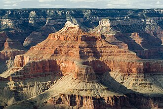
Relative long distance photo of Isis Temple (adjacent prominence is Tiyo Point, of the North Rim)
Pan 8 of 8 - Komo Point - Flickr - brewbooks.jpg
The entire Tonto Group 3-unit sequence is visible above the Colorado River (side intersecting canyon to Granite Gorge)
Komo Point view - Flickr - brewbooks.jpg
(From Komo Point)-Sloping Supai Group redbeds upon Redwall Limestone cliffs and horizontal platforms on the Muav Limestone on (white)-greenish (slopes) of Bright Angel Shale

The units of the Tonto Group and the colorful Bright Angel Shale are easily identified as a geological sequence beneath the tall cliffs of the Redwall Limestone (the Redwall sits upon a short resistant cliff of Muav Limestone); the Tonto Group is also easily seen beside Granite Gorge of the Colorado River and the Vishnu Basement Rocks

See also

Related Research Articles

<span class="mw-page-title-main">Geology of the Grand Canyon area</span> Aspect of geology

The geology of the Grand Canyon area includes one of the most complete and studied sequences of rock on Earth. The nearly 40 major sedimentary rock layers exposed in the Grand Canyon and in the Grand Canyon National Park area range in age from about 200 million to nearly 2 billion years old. Most were deposited in warm, shallow seas and near ancient, long-gone sea shores in western North America. Both marine and terrestrial sediments are represented, including lithified sand dunes from an extinct desert. There are at least 14 known unconformities in the geologic record found in the Grand Canyon.

<span class="mw-page-title-main">Great Unconformity</span> Gap in geological strata

Of the many unconformities (gaps) observed in geological strata, the term Great Unconformity is frequently applied to either the unconformity observed by James Hutton in 1787 at Siccar Point in Scotland, or that observed by John Wesley Powell in the Grand Canyon in 1869. Both instances are exceptional examples of where the contacts between sedimentary strata and either sedimentary or crystalline strata of greatly different ages, origins, and structure represent periods of geologic time sufficiently long to raise great mountains and then erode them away.

<span class="mw-page-title-main">Tonto Group</span> Cambrian geologic unit in the Grand Canyon region, Arizona

The Tonto Group is a name for an assemblage of related sedimentary strata, collectively known by geologists as a Group, that comprises the basal sequence Paleozoic strata exposed in the sides of the Grand Canyon. As currently defined, the Tonto groups consists of the Sixtymile Formation, Tapeats Sandstone, Bright Angel Shale, Muav Limestone, and Frenchman Mountain Dolostone. Historically, it included only the Tapeats Sandstone, Bright Angel Shale, and Muav Limestone. Because these units are defined by lithology and three of them interfinger and intergrade laterally, they lack the simple layer cake geology as they are typically portrayed as having and geological mapping of them is complicated.

<span class="mw-page-title-main">Muav Limestone</span> Cambrian geologic formation found in the Southwestern United States

The Muav Limestone is a Cambrian geologic formation within the 5-member Tonto Group. It is a thin-bedded, gray, medium to fine-grained, mottled dolomite; coarse- to medium-grained, grayish-white, sandy dolomite and grayish-white, mottled, fine-grained limestone. It also contains beds of shale and intraformational conglomerate. The beds of the Muav Limestone are either structureless or exhibit horizontally laminations and cross-stratification. The Muav Limestone forms cliffs or small ledges that weather a dark gray or rusty-orange color. These cliffs or small ledges directly overlie the sloping surfaces of the Bright Angel Shale. The thickness of this formation decreases eastward from 250 feet (76 m) in the western Grand Canyon to 45 feet (14 m) in the eastern Grand Canyon. To the west in southern Nevada, its thickness increases to 830 feet (250 m) in the Frenchman Mountain region.

<span class="mw-page-title-main">Tapeats Sandstone</span> Cambrian geologic formation found in the Southwestern United States

Except where underlain by the Sixtymile Formation, the Tapeats Sandstone is the Cambrian geologic formation that is the basal geologic unit of the Tonto Group. Typically, it is also the basal geologic formation of the Phanerozoic strata exposed in the Grand Canyon, Arizona, and parts of northern Arizona, central Arizona, southeast California, southern Nevada, and southeast Utah. The Tapeats Sandstone is about 230 feet (70 m) thick, at its maximum. The lower and middle sandstone beds of the Tapeats Sandstone are well-cemented, resistant to erosion, and form brownish, vertical cliffs that rise above the underlying Precambrian strata outcropping within Granite Gorge. They form the edge of the Tonto Platform. The upper beds of the Tapeats Sandstone form the surface of the Tonto Platform. The overlying soft shales and siltstones of the Bright Angel Shale underlie drab-greenish slopes that rise from the Tonto Platform to cliffs formed by limestones of the Muav Limestone and dolomites of the Frenchman Mountain Dolostone.

<span class="mw-page-title-main">Unkar Group</span> Sequence of geologic strata of Proterozoic age

The Unkar Group is a sequence of strata of Proterozoic age that are subdivided into five geologic formations and exposed within the Grand Canyon, Arizona, Southwestern United States. The 5-unit Unkar Group is the basal member of the 8-member Grand Canyon Supergroup. The Unkar is about 1,600 to 2,200 m thick and composed, in ascending order, of the Bass Formation, Hakatai Shale, Shinumo Quartzite, Dox Formation, and Cardenas Basalt. Units 4 & 5 are found mostly in the eastern region of Grand Canyon. Units 1 through 3 are found in central Grand Canyon. The Unkar Group accumulated approximately between 1250 and 1104 Ma. In ascending order, the Unkar Group is overlain by the Nankoweap Formation, about 113 to 150 m thick; the Chuar Group, about 1,900 m (6,200 ft) thick; and the Sixtymile Formation, about 60 m (200 ft) thick. These are all of the units of the Grand Canyon Supergroup. The Unkar Group makes up approximately half of the thickness of the 8-unit Supergroup.

<span class="mw-page-title-main">Nankoweap Formation</span> Neoproterozoic geologic sequence of the Grand Canyon Supergroup

The Neoproterozoic Nankoweap Formation, is a thin sequence of distinctive red beds that consist of reddish brown and tan sandstones and subordinate siltstones and mudrocks that unconformably overlie basaltic lava flows of the Cardenas Basalt of the Unkar Group and underlie the sedimentary strata of the Galeros Formation of the Chuar Group. The Nankoweap Formation is slightly more than 100 m in thickness. It is informally subdivided into informal lower and upper members that are separated and enclosed by unconformities. Its lower (ferruginous) member is 0 to 15 m thick. The Grand Canyon Supergroup, of which the Nankoweap Formation is part, unconformably overlies deeply eroded granites, gneisses, pegmatites, and schists that comprise Vishnu Basement Rocks.

<span class="mw-page-title-main">Temple Butte</span> Landform in the Grand Canyon, Arizona

Temple Butte, in the Grand Canyon, Arizona, US is a prominence below the East Rim. The butte lies on the west bank of the south-flowing Colorado River. The outfall from the Little Colorado River, draining from the Painted Desert to the east and southeast, is about two miles upstream.

<span class="mw-page-title-main">Isis Temple</span> Landform in the Grand Canyon, Arizona

Isis Temple is a prominence in the Grand Canyon, Arizona, Southwestern United States. It is located below the North Rim and adjacent to the Granite Gorge along the Colorado River. The Trinity Creek and canyon flow due south at its west border; its north, and northeast border/flank is formed by Phantom Creek and canyon, a west tributary of Bright Angel Creek; the creeks intersect about 3 mi (4.8 km) southeast, and 1.0 mi (1.6 km) north of Granite Gorge. The Isis Temple prominence, is only about 202 ft (62 m) lower than Grand Canyon Village, the main public center on Grand Canyon’s South Rim.

<span class="mw-page-title-main">Grand Canyon Supergroup</span> Sequence of sedimentary strata

The Grand Canyon Supergroup is a Mesoproterozoic to a Neoproterozoic sequence of sedimentary strata, partially exposed in the eastern Grand Canyon of Arizona. This group comprises the Unkar Group, Nankoweap Formation, Chuar Group and the Sixtymile Formation, which overlie Vishnu Basement Rocks. Several notable landmarks of the Grand Canyon, such as the Isis Temple and Cheops Pyramid, and the Apollo Temple, are surface manifestations of the Grand Canyon Supergroup.

<span class="mw-page-title-main">Hakatai Shale</span> Mesoproterozoic rock formation

The Hakatai Shale is a Mesoproterozoic rock formation with important exposures in the Grand Canyon, Coconino County, Arizona. It consists of colorful strata that exhibit colors varying from purple to red to brilliant orange. These colors are the result of the oxidation of iron-bearing minerals in the Hakatai Shale. It consists of lower and middle members that consist of bright-red, slope-forming, highly fractured, argillaceous mudstones and shale and an upper member composed of purple and red, cliff-forming, medium-grained sandstone. Its thickness, which apparently increases eastwards, varies from 137 to 300 m. In general, the Hakatai Shale and associated strata of the Unkar Group rocks dip northeast (10–30°) toward normal faults that dip 60° or more toward the southwest. This can be seen at the Palisades fault in the eastern part of the main Unkar Group outcrop area. In addition, thick, prominent, and dark-colored basaltic sills and dikes cut across the purple to red to brilliant orange strata of the Hakatai Shale.

<span class="mw-page-title-main">Surprise Canyon Formation</span> Landform in the Grand Canyon, Arizona

The Surprise Canyon Formation is a geologic formation that consists of clastic and calcareous sedimentary rocks that fill paleovalleys and paleokarst of Late Mississippian (Serpukhovian) age in Grand Canyon. These strata outcrop as isolated, lens-shaped exposures of rocks that fill erosional valleys and locally karsted topography and caves developed in the top of the Redwall Limestone. The Surprise Canyon Formation and associated unconformities represent a significant period of geologic time between the deposition of the Redwall Limestone and the overlying Supai Group.

<span class="mw-page-title-main">Bass Formation</span> Lithostratigraphic unit found in Arizona, US

The Bass Formation, also known as the Bass Limestone, is a Mesoproterozoic rock formation that outcrops in the eastern Grand Canyon, Coconino County, Arizona. The Bass Formation erodes as either cliffs or stair-stepped cliffs. In the case of the stair-stepped topography, resistant dolomite layers form risers and argillite layers form steep treads. In general, the Bass Formation in the Grand Canyon region and associated strata of the Unkar Group-rocks dip northeast (10°–30°) toward normal faults that dip 60+° toward the southwest. This can be seen at the Palisades fault in the eastern part of the main Unkar Group outcrop area. In addition, thick, prominent, and dark-colored basaltic sills intrude across the Bass Formation.

<span class="mw-page-title-main">Shinumo Quartzite</span> Mesoproterozoic rock formation in the Grand Canyon, Arizona

The Shinumo Quartzite also known as the Shinumo Sandstone, is a Mesoproterozoic rock formation, which outcrops in the eastern Grand Canyon, Coconino County, Arizona,. It is the 3rd member of the 5-unit Unkar Group. The Shinumo Quartzite consists of a series of massive, cliff-forming sandstones and sedimentary quartzites. Its cliffs contrast sharply with the stair-stepped topography of typically brightly-colored strata of the underlying slope-forming Hakatai Shale. Overlying the Shinumo, dark green to black, fissile, slope-forming shales of the Dox Formation create a well-defined notch. It and other formations of the Unkar Group occur as isolated fault-bound remnants along the main stem of the Colorado River and its tributaries in Grand Canyon.

Typically, the Shinumo Quartzite and associated strata of the Unkar Group dip northeast (10°–30°) toward normal faults that dip 60+° toward the southwest. This can be seen at the Palisades fault in the eastern part of the main Unkar Group outcrop area.

<span class="mw-page-title-main">Supai Group</span> Section of red bed deposits at the Colorado Plateau

The Supai Group is a slope-forming section of red bed deposits found in the Colorado Plateau. The group was laid down during the Pennsylvanian to Lower Permian. Cliff-forming interbeds of sandstone are noticeable throughout the group. The Supai Group is especially exposed throughout the Grand Canyon in northwest Arizona, as well as local regions of southwest Utah, such as the Virgin River valley region. It occurs in Arizona at Chino Point, Sycamore Canyon, and famously at Sedona as parts of Oak Creek Canyon. In the Sedona region, it is overlain by the Hermit Formation, and the colorful Schnebly Hill Formation.

<span class="mw-page-title-main">Dox Formation</span> Landform in the Grand Canyon, Arizona

The Dox Formation, also known as the Dox Sandstone, is a Mesoproterozoic rock formation that outcrops in the eastern Grand Canyon, Coconino County, Arizona. The strata of the Dox Formation, except for some more resistant sandstone beds, are relatively susceptible to erosion and weathering. The lower member of the Dox Formation consists of silty-sandstone and sandstone, and some interbedded argillaceous beds, that form stair-stepped, cliff-slope topography. The bulk of the Dox Formation typically forms rounded and sloping hill topography that occupies an unusually broad section of the canyon.

The Neoproterozoic Chuar Group consists of 5,250 feet (1,600 m) of fossiliferous, unmetamorphosed sedimentary strata that is composed of about 85% mudrock. The Group is the approximate upper half of the Grand Canyon Supergroup, overlain by the thin, in comparison, Sixtymile Formation, the top member of the multi-membered Grand Canyon Supergroup.

<span class="mw-page-title-main">Sixtymile Formation</span> Cambrian geologic formation found in Grand Canyon, Arizona

The Sixtymile Formation is a very thin accumulation of sandstone, siltstone, and breccia underlying the Tapeats Sandstone that is exposed in only four places in the Chuar Valley. These exposures occur atop Nankoweap Butte and within Awatubi and Sixtymile Canyons in the eastern Grand Canyon, Arizona. The maximum preserved thickness of the Sixtymile Formation is about 60 meters (200 ft). The actual depositional thickness of the Sixtymile Formation is unknown owing to erosion prior to deposition of the Tapeats Sandstone.

<span class="mw-page-title-main">Zoroaster Temple</span> Landform in Coconino County, Arizona

Zoroaster Temple is a 7,123-foot-elevation (2,171-meter) summit located in the Grand Canyon, in Coconino County of Arizona, USA. It is situated 5.5 miles (8.9 km) northeast of the Yavapai Point overlook on the canyon's South Rim, from which it can be seen towering over 4,600 feet above the Colorado River and Granite Gorge. Its nearest higher neighbor is Brahma Temple, less than one mile to the north-northeast. Zoroaster Temple is named for Zoroaster, an ancient Iranian prophet. This name was used by George Wharton James and Clarence Dutton. Dutton began the tradition of naming geographical features in the Grand Canyon after mythological deities. This geographical feature's name was officially adopted in 1906 by the U.S. Board on Geographic Names.

The Frenchman Mountain Dolostone is the uppermost and youngest of five Cambrian geologic formations that comprise the Tonto Group. It consists of beds of mottled white to gray dolomite often separated by thin seams of shale, especially in its lower part. In the Grand Canyon, this formation forms vertical cliffs that thicken westward between the top of the Muav Limestone and the base of either the Devonian Temple Butte Formation or Mississippian Redwall Limestone. Because of unidentified trace fossils and lack of datable body fossils, the Frenchman Mountain Dolostone exact age is uncertain. Within the Grand Canyon, its thickness varies between 200 and 450 feet. West into the Lake Mead region, it thickens considerably and is 1,217 feet (371 m) thick at Frenchman Mountain near Las Vegas, Nevada.

References

  1. 1 2 Karlstrom, K.E., Mohr, M.T., Schmitz, M.D., Sundberg, F.A., Rowland, S.M., Blakey, R., Foster, J.R., Crossey, L.J., Dehler, C.M. and Hagadorn, J.W., 2020. Redefining the Tonto Group of Grand Canyon and recalibrating the Cambrian time scale. Geology, 48(5), pp. 425–430.
  2. 1 2 3 4 5 6 7 Middleton, L.T. and Elliott, D.K., 2003. Tonto Group, in Beus, S. S., and Morales, M., eds. Grand Canyon geology Museum of Northern Arizona Press, Flagstaff, Arizona. pp. 90–106.
  3. 1 2 3 4 Noble, L.F., 1914. The Shinumo quadrangle, Grand Canyon district, Arizona.U.S. Geological Survey Bulletin. 549. doi:10.3133/B549. ISSN   0083-1093.
  4. 1 2 3 4 5 6 Connors, T.B., Tweet, J.S., and Santucci, V.L., 2020. Stratigraphy of Grand Canyon National Park. In: Santucci, V.L., Tweet, J.S., ed., pp. 54–74, Grand Canyon National Park: Centennial Paleontological Resource Inventory (Non-sensitive Version) . Natural Resource Report NPS/GRCA/NRR—2020/2103. National Park Service, Fort Collins, Colorado, 603 pp.
  5. 1 2 Gilbert, G.K., 1875. Report upon the geology of portions of Nevada, Utah, California, and Arizona, Chapter 6. In Wheeler, G.M., ed., pp. 17–187, Report on the Geographical and Geological Explorations and Surveys West of the One Hundredth Meridian, vol. 3. U.S. Geological and Geographical Survey, Publication of the Wheeler Survey, Washington, D.C., 681 pp.
  6. 1 2 Noble, L.F., 1922. A section of the Paleozoic formations of the Grand Canyon at the Bass Trail. U.S. Geological Survey Bulletin. 131-B, pp. 23–73
  7. 1 2 3 4 5 6 McKee, E.D., and Resser, C.E., 1945, Cambrian history of the Grand Canyon region.Carnegie Institution of Washington Publication 563, 168 pp.
  8. Huntoon, P.W., 1977. Cambrian stratigraphic nomenclature and ground‐water prospecting failures on the Hualapai Plateau, Arizona.Groundwater, 15(6), pp.426-433.
  9. Huntoon, P. W. (1989). Cambrian stratigraphic nomenclature, Grand Canyon, Arizona: Mappers nightmare, in Elston, D.P., Billingsley, G.H., and Young, R.A., eds. Geology of Grand Canyon, northern Arizona (with Colorado River guides): Lees Ferry to Pierce Ferry, Arizona. Field trips for the 28th international geological congress. Museum of Northern Arizona Press, Flagstaff, Arizona. pp. 128–129. doi:10.1029/FT115p0128
  10. 1 2 Foster, R.J., 2011. Trilobites and other fauna from two quarries in the Bright Angel Shale (Middle Cambrian, Series 3; Delamaran), Grand Canyon National Park, Arizona. in Hollingsworth, J.S., Sundberg, F.A. & Foster, J.R., eds. Cambrian Stratigraphy and Paleontology of Northern Arizona and Southern Nevada.Museum of Northern Arizona Bulletin, 67:99–120.
  11. 1 2 3 Miller, A.E., Marchetti, L., Francischini, H., Lucas, S.G., 2020. Paleozoic invertebrate ichnology of Grand Canyon national Park. In: Santucci, V.L., Tweet, J.S., ed., pp. 277–331, Grand Canyon National Park: Centennial Paleontological Resource Inventory (Non-sensitive Version) . Natural Resource Report NPS/GRCA/NRR—2020/2103. National Park Service, Fort Collins, Colorado, 603 pp.
  12. 1 2 Baldwin, C.T., Strother, P.K. , Beck, J.H. , and Rose, E., 2004. Palaeoecology of the Bright Angel Shale in the eastern Grand Canyon, Arizona, USA, incorporating sedimentological, ichnological and palynological data. In: D. McIlroy, ed., pp. 213-236. The application of ichnology to palaeoenvironmental and stratigraphic analysis. Special Publications 228. Geological Society of London, London, United Kingdom.
  13. Karlstrom, K., Hagadorn, J., Gehrels, G., Matthews, W., Schmitz, M., Madronich, L., Mulder, J., Pecha, M., Giesler, D. and Crossey, L., 2018. Cambrian Sauk transgression in the Grand Canyon region redefined by detrital zircons. Nature Geoscience, 11(6), pp.438-443.

Further reading