Great Unconformity

Last updated
Stratigraphy of the Grand Canyon.png

Of the many unconformities (gaps) observed in geological strata, the term Great Unconformity is frequently applied to either the unconformity observed by James Hutton in 1787 at Siccar Point in Scotland, [1] [ failed verification ] or that observed by John Wesley Powell in the Grand Canyon in 1869. [2] Both instances are exceptional examples of where the contacts between sedimentary strata and either sedimentary or crystalline strata of greatly different ages, origins, and structure represent periods of geologic time sufficiently long to raise great mountains and then erode them away.

Contents

Background

Unconformities tend to reflect long-term changes in the pattern of the accumulation of sedimentary or igneous strata in low-lying areas (often ocean basins, such as the Gulf of Mexico or the North Sea, but also Bangladesh and much of Brazil), then being uplifted and eroded (such as the ongoing Himalayan orogeny, the older Laramide orogeny of the Rocky Mountains, or much older Appalachian (Alleghanian) and Ouachita orogenies), then subsequently subsiding, eventually to be buried under younger sediments. The intervening periods of tectonic uplift are generally periods of mountain building, often due to the collision of tectonic plates. The "great" unconformities of regional or continental scale (in both geography and chronology) are associated with either global changes in eustatic sea level or the supercontinent cycle, the periodic merger of all the continents into one approximately every 500 million years.

Hutton's Unconformity

Hutton's Unconformity at Siccar Point, in county of Berwickshire on the east coast of Scotland, is an angular unconformity that consists of gently dipping, reddish, Upper Devonian and Lower Carboniferous breccias, sandstones, and conglomerates of the Old Red Sandstone overlying deeply eroded, near-vertical, greyish, Silurian (Llandovery) greywackes and shales. The Llandovery greywackes and graptolite-bearing shales of the Gala Group were deposited by turbidity currents in a deep sea environment about 425 million years ago. The overlying Devonian strata were deposited by rivers and streams about 345 million years ago. Thus, this unconformity reflects a gap of about 80 million years during which deep sea sediments were lithified, folded, and uplifted; later deeply eroded and weathered subaerially; and finally buried by river and stream sediments. [1] [3] [4]

Exposures of the unconformity at Siccar Point, provided James Hutton, accompanied by John Playfair and Sir James Hall, the clearest example of an unconformable relationship between two sets of sedimentary strata that involved a complex geological history. The clear truncation of near-vertical Silurian sedimentary strata by well-bedded conglomerates and sandstones belonging to the Upper Old Red Sandstone allowed Hutton to demonstrate the existence of significant breaks in the geological record, in this case a break separating strata that were then called alpine schistus and secondary strata. This and other unconformities provided evidence for Hutton's ideas about the recycling of geological materials and for unconformities representing very large time periods. He argued that these concepts pointed to the great antiquity of the Earth and the vastness of the geological time-scale. [1] [5]

Powell’s Unconformity, Grand Canyon

Powell's Unconformity viewed from Lipan Point on the South Rim. Rocks of the Unkar Group of the Grand Canyon Supergroup are truncated at the base of the Tonto Group View from Lipan Point.jpg
Powell's Unconformity viewed from Lipan Point on the South Rim. Rocks of the Unkar Group of the Grand Canyon Supergroup are truncated at the base of the Tonto Group
Powell's Unconformity seen from Hopi Point on the South Rim. Steeply foliated and veined schists of the Vishnu Basement Rocks truncated at the base of the Tonto Group Great Unconformity Tapeats Sandstone over Vishnu Schist from Hopi Point.jpg
Powell's Unconformity seen from Hopi Point on the South Rim. Steeply foliated and veined schists of the Vishnu Basement Rocks truncated at the base of the Tonto Group

The Great Unconformity of Powell in the Grand Canyon is a regional unconformity that separates the Tonto Group from the underlying, faulted and tilted sedimentary rocks of the Grand Canyon Supergroup and vertically foliated metamorphic and igneous rocks of the Vishnu Basement Rocks. The unconformity between the Tonto Group and the Vishnu Basement Rocks is a nonconformity. The break between the Tonto Group and the Grand Canyon Supergroup is an angular unconformity. [6] [7] [8]

Powell's Great Unconformity is part of a continent-wide unconformity that extends across Laurentia, the ancient core of North America. It was first recognized twelve years before Powell's expedition by John Newberry in New Mexico, during the Ives expedition of 1857–1858. However, the disruption of the American Civil War kept Newberry's work from becoming widely known. [9] This Great Unconformity marks the progressive submergence of this landmass by a shallow cratonic sea and its burial by shallow marine sediments of the Cambrian-Early Ordovician Sauk sequence. The submergence of Laurentia ended a lengthy period of widespread continental denudation that exhumed and deeply eroded Precambrian rocks and exposed them to extensive physical and chemical weathering at the Earth's surface. As a result, Powell's Great Unconformity is unusual in its geographic extent and its stratigraphic significance. [10] [11]

The length of time represented by Powell's Great Unconformity varies along its length. Within the Grand Canyon, the Great Unconformity represents a period of about 175 million years between the Tonto Group and the youngest subdivision, the Sixtymile Formation, of the Grand Canyon Supergroup. At the base of the Grand Canyon Supergroup, where it truncates the Bass Formation, the period of time represented by this angular unconformity increases to about 725 million years. Where the Tonto Group overlies the Vishnu Basement Rocks, the Great Unconformity represents a period as much as 1.2 to 1.6 billion years. [7] [11] (See also geological timescale.)

An exposure of Powell's Great Unconformity, west of Montezuma, New Mexico Arroyo Penasco Group.jpg
An exposure of Powell's Great Unconformity, west of Montezuma, New Mexico

Frenchman Mountain, Nevada

A prominent exposure of Powell's Great Unconformity occurs in Frenchman Mountain in Nevada. Frenchman Mountain exposes a sequence of Phanerozoic strata equivalent to those found in the Grand Canyon. At the base of this sequence, the Great Unconformity, with the Tapeats Sandstone of the Tonto Group overlying the Vishnu Basement Rocks, is well exposed in a manner that is atypical and scientifically significant in its combination of extent and accessibility. This exposure is frequently illustrated in popular and educational publications, and is often part of geological fieldtrips. There is a gap of about 1.2 billion years where 550 million year old strata of the Tapeats Sandstone rests on 1.7 billion (1700 million) year old Vishnu Basement Rocks. [12] [13] [14]

As a widespread phenomenon

The term "Great Unconformity" has also been used to refer to the anomalous concentration of unconformities, including basement nonconformities, below the base of the Cambrian. [15] Charles Walcott was among the first to note this phenomenon, remarking in 1910: [16]

I do not know of a case of proven conformity between Cambrian and pre-Cambrian Algonkian rocks on the North American continent. In all localities where the contact is sufficiently extensive, or where fossils have been found in the basal Cambrian beds or above the basal conglomerate and coarser sandstones, an unconformity has been found to exist. Stated in another way, the pre-Cambrian land surface was formed of sedimentary, eruptive, and crystalline rocks that did not in any known instance immediately precede in deposition or origin the Cambrian sediments. Everywhere there is a stratigraphic and time break between the known pre-Cambrian rocks and Cambrian sediments of the North American continent.

Charles D Walcott, "Abrupt Appearance of the Cambrian Fauna on the North American Continent", Cambrian Geology and Paleontology (1910)

A potential link has been proposed between such sub-Cambrian unconformities and glacial erosion during the Neoproterozoic Snowball Earth glaciations. [17] [18] Alternatively, it has been proposed that multiple smaller events, such as the formation and breakup of Rodinia, created many unconformities worldwide. [19] [20] [21] [22] Evidence indicates that the Pikes Peak unconformity was formed before the Snowball Earth glaciations. [23]

Possible causes of the Great Unconformity

There is currently no widely accepted explanation for the Great Unconformity among geoscientists. There are hypotheses that have been proposed; it is widely accepted that there was a combination of more than one event which may have caused such an extensive phenomenon. One example is a large glaciation event which took place during the Neoproterozoic, starting around 720 million years ago. [18] [24] [25] This is also when a significant glaciation event known as 'Snowball Earth' occurred. [18] Snowball Earth covered almost the entire planet with ice. The areas that underwent glaciation were approximately those where the Great Unconformity is located today. When glaciers move, they drag and erode sediment away from the underlying rock. This would explain how a large section of rock was taken away from widespread areas around the same time.

See also

Related Research Articles

<span class="mw-page-title-main">Snowball Earth</span> Worldwide glaciation episodes during the Proterozoic eon

The Snowball Earth is a geohistorical hypothesis that proposes during one or more of Earth's icehouse climates, the planet's surface became entirely or nearly entirely frozen with no liquid oceanic or surface water exposed to the atmosphere. The most academically referred period of such global glaciation is believed to have occurred sometime before 650 mya during the Cryogenian period.

<span class="mw-page-title-main">Unconformity</span> Rock surface indicating a gap in the geological record

An unconformity is a buried erosional or non-depositional surface separating two rock masses or strata of different ages, indicating that sediment deposition was not continuous. In general, the older layer was exposed to erosion for an interval of time before deposition of the younger layer, but the term is used to describe any break in the sedimentary geologic record. The significance of angular unconformity was shown by James Hutton, who found examples of Hutton's Unconformity at Jedburgh in 1787 and at Siccar Point in Berwickshire in 1788, both in Scotland.

<span class="mw-page-title-main">Geology of the Grand Canyon area</span> Aspect of geology

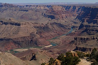
The geology of the Grand Canyon area includes one of the most complete and studied sequences of rock on Earth. The nearly 40 major sedimentary rock layers exposed in the Grand Canyon and in the Grand Canyon National Park area range in age from about 200 million to nearly 2 billion years old. Most were deposited in warm, shallow seas and near ancient, long-gone sea shores in western North America. Both marine and terrestrial sediments are represented, including lithified sand dunes from an extinct desert. There are at least 14 known unconformities in the geologic record found in the Grand Canyon.

<span class="mw-page-title-main">Frenchman Mountain</span>

Frenchman Mountain is a mountain located east of Las Vegas, Nevada. Made up of rocks similar to those found on the bottom of the Grand Canyon, Frenchman Mountain formed when faulting elevated and tilted the rocks followed by erosion, giving it its sharp triangular profile. The mountain provides an example of the Great Unconformity with the tilted Paleozoic Tapeats Sandstone underlain by Paleoproterozoic Vishnu Schist, which is some of the oldest rock on the North American continent, having been created about two billion years ago.

<span class="mw-page-title-main">Tonto Group</span> Cambrian geologic unit in the Grand Canyon region, Arizona

The Tonto Group is a name for an assemblage of related sedimentary strata, collectively known by geologists as a Group, that comprises the basal sequence Paleozoic strata exposed in the sides of the Grand Canyon. As currently defined, the Tonto groups consists of the Sixtymile Formation, Tapeats Sandstone, Bright Angel Shale, Muav Limestone, and Frenchman Mountain Dolostone. Historically, it included only the Tapeats Sandstone, Bright Angel Shale, and Muav Limestone. Because these units are defined by lithology and three of them interfinger and intergrade laterally, they lack the simple layer cake geology as they are typically portrayed as having and geological mapping of them is complicated.

<span class="mw-page-title-main">Tapeats Sandstone</span> Cambrian geologic formation found in the Southwestern United States

Except where underlain by the Sixtymile Formation, the Tapeats Sandstone is the Cambrian geologic formation that is the basal geologic unit of the Tonto Group. Typically, it is also the basal geologic formation of the Phanerozoic strata exposed in the Grand Canyon, Arizona, and parts of northern Arizona, central Arizona, southeast California, southern Nevada, and southeast Utah. The Tapeats Sandstone is about 230 feet (70 m) thick, at its maximum. The lower and middle sandstone beds of the Tapeats Sandstone are well-cemented, resistant to erosion, and form brownish, vertical cliffs that rise above the underlying Precambrian strata outcropping within Granite Gorge. They form the edge of the Tonto Platform. The upper beds of the Tapeats Sandstone form the surface of the Tonto Platform. The overlying soft shales and siltstones of the Bright Angel Shale underlie drab-greenish slopes that rise from the Tonto Platform to cliffs formed by limestones of the Muav Limestone and dolomites of the Frenchman Mountain Dolostone.

<span class="mw-page-title-main">Cardenas Basalt</span> Rock formation in the Grand Canyon, Arizona

The Cardenas Basalt, also known as either the Cardenas Lava or Cardenas Lavas, is a rock formation that outcrops over an area of about 310 km2 (120 mi2) in the eastern Grand Canyon, Coconino County, Arizona. The lower part of the Cardenas Basalt forms granular talus slopes. Its upper part forms nearly continuous low cliffs that are parallel to the general course of the Colorado River. The most complete, readily accessible, and easily studied exposure of the Cardenas Basalt lies in Basalt Canyon. This is also its type locality.

<span class="mw-page-title-main">Unkar Group</span> Sequence of geologic strata of Proterozoic age

The Unkar Group is a sequence of strata of Proterozoic age that are subdivided into five geologic formations and exposed within the Grand Canyon, Arizona, Southwestern United States. The 5-unit Unkar Group is the basal member of the 8-member Grand Canyon Supergroup. The Unkar is about 1,600 to 2,200 m thick and composed, in ascending order, of the Bass Formation, Hakatai Shale, Shinumo Quartzite, Dox Formation, and Cardenas Basalt. Units 4 & 5 are found mostly in the eastern region of Grand Canyon. Units 1 through 3 are found in central Grand Canyon. The Unkar Group accumulated approximately between 1250 and 1104 Ma. In ascending order, the Unkar Group is overlain by the Nankoweap Formation, about 113 to 150 m thick; the Chuar Group, about 1,900 m (6,200 ft) thick; and the Sixtymile Formation, about 60 m (200 ft) thick. These are all of the units of the Grand Canyon Supergroup. The Unkar Group makes up approximately half of the thickness of the 8-unit Supergroup.

<span class="mw-page-title-main">Nankoweap Formation</span> Neoproterozoic geologic sequence of the Grand Canyon Supergroup

The Neoproterozoic Nankoweap Formation, is a thin sequence of distinctive red beds that consist of reddish brown and tan sandstones and subordinate siltstones and mudrocks that unconformably overlie basaltic lava flows of the Cardenas Basalt of the Unkar Group and underlie the sedimentary strata of the Galeros Formation of the Chuar Group. The Nankoweap Formation is slightly more than 100 m in thickness. It is informally subdivided into informal lower and upper members that are separated and enclosed by unconformities. Its lower (ferruginous) member is 0 to 15 m thick. The Grand Canyon Supergroup, of which the Nankoweap Formation is part, unconformably overlies deeply eroded granites, gneisses, pegmatites, and schists that comprise Vishnu Basement Rocks.

<span class="mw-page-title-main">Grand Canyon Supergroup</span> Sequence of sedimentary strata

The Grand Canyon Supergroup is a Mesoproterozoic to a Neoproterozoic sequence of sedimentary strata, partially exposed in the eastern Grand Canyon of Arizona. This group comprises the Unkar Group, Nankoweap Formation, Chuar Group and the Sixtymile Formation, which overlie Vishnu Basement Rocks. Several notable landmarks of the Grand Canyon, such as the Isis Temple and Cheops Pyramid, and the Apollo Temple, are surface manifestations of the Grand Canyon Supergroup.

<span class="mw-page-title-main">Hakatai Shale</span> Mesoproterozoic rock formation

The Hakatai Shale is a Mesoproterozoic rock formation with important exposures in the Grand Canyon, Coconino County, Arizona. It consists of colorful strata that exhibit colors varying from purple to red to brilliant orange. These colors are the result of the oxidation of iron-bearing minerals in the Hakatai Shale. It consists of lower and middle members that consist of bright-red, slope-forming, highly fractured, argillaceous mudstones and shale and an upper member composed of purple and red, cliff-forming, medium-grained sandstone. Its thickness, which apparently increases eastwards, varies from 137 to 300 m. In general, the Hakatai Shale and associated strata of the Unkar Group rocks dip northeast (10–30°) toward normal faults that dip 60° or more toward the southwest. This can be seen at the Palisades fault in the eastern part of the main Unkar Group outcrop area. In addition, thick, prominent, and dark-colored basaltic sills and dikes cut across the purple to red to brilliant orange strata of the Hakatai Shale.

<span class="mw-page-title-main">Bass Formation</span> Lithostratigraphic unit found in Arizona, US

The Bass Formation, also known as the Bass Limestone, is a Mesoproterozoic rock formation that outcrops in the eastern Grand Canyon, Coconino County, Arizona. The Bass Formation erodes as either cliffs or stair-stepped cliffs. In the case of the stair-stepped topography, resistant dolomite layers form risers and argillite layers form steep treads. In general, the Bass Formation in the Grand Canyon region and associated strata of the Unkar Group-rocks dip northeast (10°–30°) toward normal faults that dip 60+° toward the southwest. This can be seen at the Palisades fault in the eastern part of the main Unkar Group outcrop area. In addition, thick, prominent, and dark-colored basaltic sills intrude across the Bass Formation.

<span class="mw-page-title-main">Shinumo Quartzite</span> Mesoproterozoic rock formation in the Grand Canyon, Arizona

The Shinumo Quartzite also known as the Shinumo Sandstone, is a Mesoproterozoic rock formation, which outcrops in the eastern Grand Canyon, Coconino County, Arizona,. It is the 3rd member of the 5-unit Unkar Group. The Shinumo Quartzite consists of a series of massive, cliff-forming sandstones and sedimentary quartzites. Its cliffs contrast sharply with the stair-stepped topography of typically brightly-colored strata of the underlying slope-forming Hakatai Shale. Overlying the Shinumo, dark green to black, fissile, slope-forming shales of the Dox Formation create a well-defined notch. It and other formations of the Unkar Group occur as isolated fault-bound remnants along the main stem of the Colorado River and its tributaries in Grand Canyon.

Typically, the Shinumo Quartzite and associated strata of the Unkar Group dip northeast (10°–30°) toward normal faults that dip 60+° toward the southwest. This can be seen at the Palisades fault in the eastern part of the main Unkar Group outcrop area.

<span class="mw-page-title-main">Dox Formation</span> Landform in the Grand Canyon, Arizona

The Dox Formation, also known as the Dox Sandstone, is a Mesoproterozoic rock formation that outcrops in the eastern Grand Canyon, Coconino County, Arizona. The strata of the Dox Formation, except for some more resistant sandstone beds, are relatively susceptible to erosion and weathering. The lower member of the Dox Formation consists of silty-sandstone and sandstone, and some interbedded argillaceous beds, that form stair-stepped, cliff-slope topography. The bulk of the Dox Formation typically forms rounded and sloping hill topography that occupies an unusually broad section of the canyon.

<span class="mw-page-title-main">Vishnu Basement Rocks</span> Lithostratigraphic unit in the Grand Canyon, Arizona

The Vishnu Basement Rocks is the name recommended for all Early Proterozoic crystalline rocks exposed in the Grand Canyon region. They form the crystalline basement rocks that underlie the Bass Limestone of the Unkar Group of the Grand Canyon Supergroup and the Tapeats Sandstone of the Tonto Group. These basement rocks have also been called either the Vishnu Complex or Vishnu Metamorphic Complex. These Early Proterozoic crystalline rocks consist of metamorphic rocks that are collectively known as the Granite Gorge Metamorphic Suite; sections of the Vishnu Basement Rocks contain Early Paleoproterozoic granite, granitic pegmatite, aplite, and granodiorite that have intruded these metamorphic rocks, and also, intrusive Early Paleoproterozoic ultramafic rocks.

<span class="mw-page-title-main">Bright Angel Shale</span> Cambrian geologic formation found in the Southwestern United States

The Bright Angel Shale is one of five geological formations that comprise the Cambrian Tonto Group. It and the other formations of the Tonto Group outcrop in the Grand Canyon, Arizona, and parts of northern Arizona, central Arizona, southeast California, southern Nevada, and southeast Utah. The Bright Angel Shale consists of locally fossiliferous, green and red-brown, micaceous, fissile shale (mudstone) and siltstone with local, thicker beds of brown to tan sandstone and limestone. It ranges in thickness from 57 to 450 feet. Typically, its thin-bedded shales and sandstones are interbedded in cm-scale cycles. They also exhibit abundant sedimentary structures that include current, oscillation, and interference ripples. The Bright Angel Shale also gradually grades downward into the underlying Tapeats Sandstone. It also complexly interfingers with the overlying Muav Limestone. These characters make the upper and lower contacts of the Bright Angel Shale often difficult to define. Typically, its thin-bedded shales and sandstones erode into green and red-brown slopes that rise from the Tonto Platform up to cliffs formed by limestones of the overlying Muav Limestone and dolomites of the Frenchman Mountain Dolostone.

The Neoproterozoic Chuar Group consists of 5,250 feet (1,600 m) of fossiliferous, unmetamorphosed sedimentary strata that is composed of about 85% mudrock. The Group is the approximate upper half of the Grand Canyon Supergroup, overlain by the thin, in comparison, Sixtymile Formation, the top member of the multi-membered Grand Canyon Supergroup.

<span class="mw-page-title-main">Sixtymile Formation</span> Cambrian geologic formation found in Grand Canyon, Arizona

The Sixtymile Formation is a very thin accumulation of sandstone, siltstone, and breccia underlying the Tapeats Sandstone that is exposed in only four places in the Chuar Valley. These exposures occur atop Nankoweap Butte and within Awatubi and Sixtymile Canyons in the eastern Grand Canyon, Arizona. The maximum preserved thickness of the Sixtymile Formation is about 60 meters (200 ft). The actual depositional thickness of the Sixtymile Formation is unknown owing to erosion prior to deposition of the Tapeats Sandstone.

<span class="mw-page-title-main">Geology of Ghana</span>

The geology of Ghana is primarily very ancient crystalline basement rock, volcanic belts and sedimentary basins, affected by periods of igneous activity and two major orogeny mountain building events. Aside from modern sediments and some rocks formed within the past 541 million years of the Phanerozoic Eon, along the coast, many of the rocks in Ghana formed close to one billion years ago or older leading to five different types of gold deposit formation, which gave the region its former name Gold Coast.

The geology of Niger comprises very ancient igneous and metamorphic crystalline basement rocks in the west, more than 2.2 billion years old formed in the late Archean and Proterozoic eons of the Precambrian. The Volta Basin, Air Massif and the Iullemeden Basin began to form in the Neoproterozoic and Paleozoic, along with numerous ring complexes, as the region experienced events such as glaciation and the Pan-African orogeny. Today, Niger has extensive mineral resources due to complex mineralization and laterite weathering including uranium, molybdenum, iron, coal, silver, nickel, cobalt and other resources.

References

  1. 1 2 3 Rance, H (1999) Historical Geology: The Present is the Key to the Past. Archived 3 December 2008 at the Wayback Machine QCC Press, New York
  2. Merten, G (2005) Geology in the American Southwest: New Processes, New Theories In MF Anderson, ed., A Gathering of Grand Canyon Historians. Proceedings of the Inaugural Grand Canyon History Symposium, January 2002. Grand Canyon Association, Grand Canyon, Arizona.
  3. Barclay, WJ, MAE Browne, AA McMillan, EA Pickett, P Stone, and PR Wilby (2005) The Old Red Sandstone of Great Britain. Geological Conservation Review Series no. 31. Joint Nature Conservation Committee, Peterborough, United Kingdom, 393 pp.
  4. Holdsworth, R. E.; Tavarnelli, E.; Clegg, P. (2002). "The nature and regional significance of structures in the Gala Group of the Southern Uplands terrane, Berwickshire coast, southeastern Scotland" (PDF). Geological Magazine. 139 (6): 707–717. Bibcode:2002GeoM..139..707H. doi:10.1017/S0016756802006854. S2CID   54197702.
  5. Jutras, Pierre; Young, Grant M.; Caldwell, W. Glen E. (2011). "Reinterpretation of James Hutton's historic discovery on the Isle of Arran as a double unconformity masked by a phreatic calcrete hardpan" (PDF). Geology. 39 (2): 147–150. Bibcode:2011Geo....39..147J. doi:10.1130/G31490.1.
  6. Billingsley, G. H. (2000). "Geologic map of the Grand Canyon 30' x 60' quadrangle, Coconino and Mohave Counties, northwestern Arizona". U.S. Geological Survey. doi:10.3133/i2688.
  7. 1 2 Timmons, M; Karlstrom, KE; Dehler, C (1998). "Grand Canyon Supergroup: Six Unconformities Make One Great Unconformity A Record of Supercontinent Assembly and Disassembly". Archived from the original on 13 July 2013.
  8. "Grand Canyon Supergroup: Six Unconformities Make One Great Unconformity A Record of Supercontinent Assembly and Disassembly" (PDF). Boatman's Quarterly Review. pp. 28–32. Archived from the original (PDF) on 28 September 2013.
  9. Kues, Barry S.; Lewis, Claudia J.; Lueth, Virgil W. (2014). A brief history of geological studies in New Mexico : with biographical profiles of notable New Mexico geologists (First ed.). New Mexico Geological Society. ISBN   978-1-58546-011-3.
  10. Peters, Shanan E.; Gaines, Robert R. (2012). "Formation of the 'Great Unconformity' as a trigger for the Cambrian explosion". Nature. 484 (7394): 363–366. Bibcode:2012Natur.484..363P. doi:10.1038/nature10969. PMID   22517163. S2CID   4423007.
  11. 1 2 Karlstrom, Karl E.; Timmons, J. Michael, eds. (2012). "Many unconformities make one 'Great Unconformity'". Grand Canyon Geology: Two Billion Years of Earth's History. Vol. 489. Boulder, Colorado: Geological Society of America. pp. 73–79. ISBN   978-0-8137-2489-8.
  12. Rowland, Stephen M. (1987). "Paleozoic stratigraphy of Frenchman Mountain, Clark County, Nevada". Cordilleran Section of the Geological Society of America. pp. 53–56. doi:10.1130/0-8137-5401-1.53. ISBN   9780813754079.
  13. Rowland, S (nd) Frenchman Mountain Great Unconformity site. Department of Geoscience, University of Nevada, Las Vegas, Nevada.
  14. Palmer, A. R. (1989). "Day 0: Early and Middle Cambrian stratigraphy of Frenchman Mountain, Nevada". Cambrian and Early Ordovician Stratigraphy and Paleontology of the Basin and Range Province, Western United States: Las Vegas, Nevada to Salt Lake City, Utah, July 1–7, 1989. pp. 14–16. doi:10.1029/FT125p0014. ISBN   0-87590-662-1.
  15. Peters, Shanan E.; Gaines, Robert R. (2012). "Formation of the 'Great Unconformity' as a trigger for the Cambrian explosion". Nature. 484 (7394): 363–366. Bibcode:2012Natur.484..363P. doi:10.1038/nature10969. PMID   22517163. S2CID   4423007.
  16. Walcott, C. D. (1910) "Abrupt appearance of the Cambrian fauna on the North American continent". Smithsonian Miscellaneous Collections 57: Cambrian Geology and Paleontology, pp. 1–16.
  17. White, W. A. (1973) "Deep Erosion by Infracambrian Ice Sheets". Geological Society of America Bulletin, v. 84, pp. 1841–1844.
  18. 1 2 3 Keller, C. Brenhin; Husson, Jon M.; Mitchell, Ross N.; Bottke, William F.; Gernon, Thomas M.; Boehnke, Patrick; Bell, Elizabeth A.; Swanson-Hysell, Nicholas L.; Peters, Shanan E. (2019-01-22). "Neoproterozoic glacial origin of the Great Unconformity". Proceedings of the National Academy of Sciences. 116 (4): 1136–1145. Bibcode:2019PNAS..116.1136B. doi: 10.1073/pnas.1804350116 . ISSN   0027-8424. PMC   6347685 . PMID   30598437.
  19. "Big chunks of history (and rock) are missing in North America, study says". CNN. April 27, 2020.
  20. Joel, L. (5 February 2018). "Erasing a Billion Years of Geologic Time Across the Globe". Eos.org.
  21. Peak, B.A.; Flowers, R.M.; Macdonald, F.A.; Cottle, J.M. (2021-08-12). "Zircon (U-Th)/He thermochronology reveals pre-Great Unconformity paleotopography in the Grand Canyon region, USA". Geology. 49 (12): 1462–1466. Bibcode:2021Geo....49.1462P. doi: 10.1130/G49116.1 . ISSN   0091-7613.
  22. Boulder, University of Colorado at (2021-08-21). ""Great Unconformity" Puzzle: Geologists Dig Into Grand Canyon's Mysterious Gap in Time". SciTechDaily. Retrieved 2021-08-28.
  23. Flowers, Rebecca M.; MacDonald, Francis A.; Siddoway, Christine S.; Havranek, Rachel (2020). "Diachronous development of Great Unconformities before Neoproterozoic Snowball Earth". Proceedings of the National Academy of Sciences. 117 (19): 10172–10180. Bibcode:2020PNAS..11710172F. doi: 10.1073/pnas.1913131117 . PMC   7229757 . PMID   32341149. S2CID   216595868.
  24. McDannell, Kalin T.; Keller, C. Brenhin; Guenthner, William R.; Zeitler, Peter K.; Shuster, David L. (2022-02-01). "Thermochronologic constraints on the origin of the Great Unconformity". Proceedings of the National Academy of Sciences. 119 (5): e2118682119. Bibcode:2022PNAS..11918682M. doi:10.1073/pnas.2118682119. ISSN   0027-8424. PMC   8812566 . PMID   35078936.
  25. College, Dartmouth (2022-01-26). "New Research Strengthens Link Between Glaciers and Earth's Puzzling "Great Unconformity"". SciTechDaily. Retrieved 2022-02-19.
Hutton's Unconformity
Powell's Unconformity