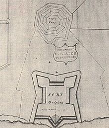
Map of Fort Gadsden, also showing the location of the original "Negro Fort". Prepared by Major James Gadsden in 1818.A Union Jack on the site of the original British fort.A commemorative plaque marks the location of the fort's powdermagazine.
Prospect Bluff Historic Sites (until 2016 known as Fort Gadsden Historic Site, and sometimes written as Fort Gadsden Historic Memorial)[4] is located in Franklin County, Florida, on the Apalachicola River, 6 miles (9.7km) SW of Sumatra, Florida. The site contains the ruins of two forts.
The earlier and larger one was built by the British in 1814, during the War of 1812. They allowed the members of the disbanded Corps of Colonial Marines, made up largely of fugitive slaves, and Creek tribesmen to occupy it after the British evacuated Florida in 1815, deliberately leaving their munitions behind. At that point, since the British had not named it, Americans started referring to it as Negro Fort. It was destroyed in a river attack from U.S. forces in 1816.
Fort Gadsden was built in 1818 within the former walls of the former Negro Fort.
The site has been known by several other names at various times, including Prospect Bluff,[5]:48 British post,[5]:48[6] Nicholls' Fort, Blount's Fort,[7][8] Fort Blount,[9] African Fort, and Fort Apalachicola.[10]:60 The local natives called the land Achackwheithle.[11]
Listed in the National Register of Historic Places and named a National Historic Landmark in 1972, the Prospect Bluff Historic Sites was acquired by the Apalachicola National Forest in 1940 and is managed by the U.S. Forest Service.[2] The process of memorializing the site began in 1961, when the Apalachicola National Forest issued the State of Florida a term special use permit for an area of approximately 78 acres (32ha) including the site to be run as a state park. Administration of the site reverted to the federal government[4] in the 1990s. The site contains interpretive signage, picnic area with pavilion, and rest rooms.[4]
Prospect Bluff
The site of both Negro Fort and the later Fort Gadsden was Prospect Bluff, "a fine bluff overlooking the Apalachicola River,"[12]:18 whose modest elevation of 12 feet (3.7m) and the swamp that almost surrounded it (description below) gave it a natural military strength. The name parallels the Spanish one, Loma de Buena Vista,[13][14]:8 literally "hill with a good view".[15]
Accessible only by river then, the site was and is still remote. The river was the boundary between East Florida and West Florida during the British Florida period (1763–1783) and the second Spanish Florida period (1783–1821). By modern land route it is 198 miles (319km) from Pensacola and 271 miles (436km) from St. Augustine. The area was sparsely populated, and in the twentieth century a large portion became the Apalachicola National Forest. The river was of intense interest to the British, who saw it as an undefended entry into the United States through Georgia. It was of no interest to the Spaniards; it led nowhere they cared about. Spanish forces in Florida were limited and Spain was far less committed to Florida than it was to its other colonies, most of them much more productive. Spain's inability to police its borders or return fugitive slaves was central to Florida's transfer to the United States in 1821.
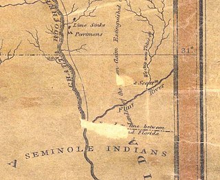
Control of Prospect Bluff meant control of the river, which had served as a transportation artery for centuries. More recently, it had enabled raiding parties to go upriver into Georgia and the Mississippi Territory via the Chattahoochee and especially the Flint River. The attacks were made on plantations, which had few if any defenses. These parties, besides coming back with material goods, saw to it that the slaves of the raided plantations could get free. This was a great economic blow to the slave owners (slaves were expensive), and an ideological affront as well,[12]:12–13 leaving them insecure and angry.
Prospect Bluff was valuable militarily not only because of the elevation its name suggests, but because it was at a "strategic location",[13] a bend in the river, giving an important sight advantage over any boat.
Before 1814
The Florida panhandle was mostly wilderness before 1814. Its population at the time is unknown, except for isolated reports. As in the rest of Florida, there were many Native American refugees from the United States, who merged into a new ethnicity, Seminoles. It provided excellent cover for escaped slaves, who, since they shared a common enemy, got along with the Seminoles fairly well; "over time, a bond developed between escaped Africans and the Seminoles that only increased with time and white pressure for their return".[12]:12–13 Some became black Seminoles. There was "reciprocal respect and affection"; the former slaves, who knew English, served as interpreters.[16]:6 This predecessor of the Underground Railroad ran south.[17][18][19] The biggest issue about the area discussed by whites was how to get escaped slaves back, or get compensation for them, and prevent or reduce future escapes. The return of Native Americans was unwanted,[20]:243 and they were soon forcibly removed from Florida as well.
As was customary in pre-railroad times, settlement took place first along rivers. The name Apalachicola River derives its name from Apalachicola Province on what is now the Chattahoochee River (the Spanish regarded what is now the Chattahoochee as part of the Apalachicola River). Settlement at Prospect Bluff by maroons (escaped slaves and their descendants), Seminoles, and a few Europeans is documented at the end of the eighteenth century.
In January 1783 a conference was held in St. Augustine between the representatives of the British Crown—Governor Patrick Tonyn, Brigadier General Archibald McArthur, and Thomas Brown, the superintendent of Indian affairs—and the head men and principal warriors of the towns of the Upper and the Lower Creeks, who complained of the long distance they must travel to the stores from which they obtained their supplies. The Indians offered protection to merchants who would move their stores to locations closer to their territory, and pointed out the Apalachicola River as a suitable place for a trading house. The Creeks said it was not only more convenient for themselves, but also much nearer to the Choctaw, Chickasaw, and Cherokee Indians, and requested that the house of Panton, Leslie & Company, who had been supplying them with goods, should be solicited to settle there for that purpose.
William Panton was present at the conference, and agreed with the Indians to establish a store at such a place as he or his co-partners might find suitable between the forks of Flint river and the mouth of the Apalachicola River, provided that letters of license were issued to him and his partners. The agreement was confirmed by the Crown, and the traders were granted the necessary license.[21] Their store opened in 1784, by which time Spain had regained possession of Florida, at Fort San Marcos de Apalache (modern St. Marks, Florida). This store was attacked and looted by the adventurer William Augustus Bowles in 1792 and again in 1800, at which point it ceased operations.[22]:60
A trading post run by John Forbes and Company, successors to Panton, Leslie & Company, was set up in 1804 at the more defensible Prospect Bluff at the request of "Indians" ("Mickosuckees" is the only ethnicity mentioned). It was "manned by Edmund Doyle with some assistance from William Hambly, an Indian trader with years of experience in the area."[12]:18[22]:63 Doyle and Hambly "each owned plantations higher up the river, at Spanish Bluff on the west bank and near present-day Bristol on the east bank."[14]:7
The site of the trading post was inside the walls of the Fort, built around it; this explains why the precise site has never been identified. It included a building for storing hides (what the Native Americans had to trade), quarters for negro slaves, and a cow pen for several hundred cattle that were raised nearby. During the War of 1812, British troops ransacked the store and freed the slaves.
Figures on the number of maroons who settled in the surrounding area range from 300 to 1,000.[23] The blacks developed plantations extending up to 50 miles along the river.[9][22]:81 A report from 1812 mentions over 36 cleared acres and 1,200 cattle,[22]:63 and they lived in "large and well-built cabins".[20]:233 Their crops were peas, beans, corn, and rice.[20]:233
The British launched an invasion of Pensacola during the War of 1812 and occupied it[25] until General Andrew Jackson took the town on November 7, 1814.[26][27] The British forces, over 100 officers and men led by a Brevet Captain of the Royal Marines, George Woodbine,[20]:42 made camp at the only community between Pensacola and St. Marks: the trading post of John Forbes and Company, surrounded by negro plantations.
It was located at Prospect Bluff. Woodbine began to train local Native Americans as well as escaped slaves.[16]:15[28][29]Nicolls recruited the ex-slaves into the new (black) Corps of Colonial Marines. They were well-armed, well-equipped, and underwent drills; many had been in training for months.[30]:69 He also assembled and trained more than five hundred Creek and Seminole Indians by February 1815, but they came from a different culture, did not like being trained,[20]:63 and did not have the incentive of being protected from American re-enslavement. Nicolls found the ex-slaves superior as soldiers, reporting that his black recruits had enlisted "with the strictest good faith and conduct, so much so, that out of 1,500 of them I never had occasion to punish one of them". He added that in contrast with British soldiers, "they would not get drunk".[20]:63
They were preparing to attack Georgia when news arrived of the end of the war.[31][32] The British paid off the Colonial Marines (at the same rate as the white Marines) and withdrew from Florida. On May 16, 1815, the British evacuated the last of the garrison there.
Blacks and Native Americans under Nicolls' direction built two forts on the Apalachicola River. The larger and more important one was to be on the border of Georgia, at the juncture of the Flint and the Chattahoochee Rivers, in modern Chattahoochee, Florida, and was to serve as the base for a U.S. invasion.[33]:9 Time only permitted the construction of a small wooden structure, which Nicolls called Fort Apalachicola, but is today referred to as Nicolls' Outpost.[34]
The larger one, which actually was built and was intended to be a supply depot for Nicolls' Outpost,[33]:21,47 did not have a name; it was referred to simply as the British Post. It was 15 miles (24km) above the river mouth and 60 miles (97km) south of Nicolls' Outpost and the border of Georgia. The construction of the larger fort was described by Brigadier GeneralEdmund P. Gaines in a letter of May 14, 1816 to Andrew Jackson, who had charged him with destroying the Fort:
The ramparts and parapets built of hewn timber filled in with earth, mounting 9 to 12 pieces of Cannon, several of which are very large, with some mortars and Howitzers. It has a deep ditch intended to be filled with water, but was dry when seen by my informants, two or three months ago. The work is nearly square and extends over near two acres [0.81 ha] of ground, has Comfortable barracks, and large stone houses inside. It is rendered inaccessible by land, except a narrow pass up near the margin of the river, by reason of an impenetrable swamp in the rear and extending to the river above.[35]
It included 4 twenty-four-pound cannons, 4 six-pound cannons, beside a field piece and a howitzer. In addition there were found 2,500 stands of muskets with accoutrements, 500 carbines and 500 swords ... 300 quarter-casks of rifle powder and 162 barrels of cannon powder, besides other stores and clothing.[22]:80–81
The area enclosed by the fort was 7 acres (34,000sqyd; 2.8ha); on the eastern corners (those most vulnerable to attack) were bastions with walls 15 feet (4.6m) high and 18 feet (5.5m) thick.[12]:18[36]
The magazine area of the fort was located about 500 feet from the river bank, and consisted of an octagonal blockhouse holding the principal magazine. This was surrounded by an extensive star-shaped enclosure covering about 16 acres with bastions on the eastern corners. The ravelin along the river with cannon was 15 feet high and 18 feet thick.[4]
Gaines estimated that 900 Native American warriors and 450 armed blacks inhabited the fort.[37][38]
A miniature replica of the later Fort Gadsden was constructed in the 1970s; a picture is in the State Archives of Florida.[39]
When the British withdrew, they deliberately left all their weapons, hoping that the locals would use them to defend themselves from U.S. attempts to re-enslave them, just as African and Native Americans had assisted the British during the American War of Independence.[5]:48–49 Most of the Native Americans (Seminoles and Red Stick Creeks) warriors who remained behind abandoned the fort soon afterwards.[40]
Some[who?] remained, along with many of the trained soldiers of the disbanded Corps of Colonial Marines, which was a British Army regiment consisting of freed slaves. [citation needed]
Over the next year the fort became a growing colony of escaped slaves from Georgia and the Mississippi Territory, and became known as the Negro Fort.[41][42][43] It was the center of the largest community of free negroes in North America before the U.S. Civil War.
The fort, located as it was near the border, was seen by the U.S. as "a beacon of light to restless and rebellious slaves,"[18] "a center of hostility and above all a threat to the security of their slaves,"[44] "a direct threat to the slave-holding interests rapidly flocking to the newly opened lands in what is today Mississippi and Alabama."[12]:20 On April 8, 1816, General Jackson ordered General Gaines to "take care of the situation", because the Fort "ought to be blown up"; it was only fomenting "rapine and plunder", and he should "return the stolen Negros and plunder to their rightful owners".[12]
whether that fort has been built by the government of Spain — and whether the negroes, who garrison it, are considered subjects of his Catholic Majesty — and if not by the authority of Spain — by whom, under whose orders, has it been established[?]
He informed Zúñiga that:
Secret practices to inveigle Negroes from the frontier citizens of Georgia as well as from the Cherokee and Creek nations of Indians are still continued by this Banditti [sic; he means the garrison] and the Hostile Creeks. This is a state of things which cannot fail to produce much injury to the neighboring settlements and incite Irritations which may ultimately endanger the peace of the nation and interrupt that good understanding that so happily exists between our governments.
He insisted on the "return to our citizens and the friendly Indians inhabiting our Territory those Negroes now in the said fort and which have been stolen and enticed from them." This conduct "will not be tolerated by our government and if not put down by the Spanish Authority will compel us in self Defence to destroy them."[45]:22–23
After Zúñiga's reply of May 26, 1816, informing Jackson that he could not act "unless I receive the Orders of my Captain General [in Cuba[46]:25] and the necessary Supplies",[45]:41–43 Jackson proceeded with his plans to destroy the Fort.
The first step was the construction of Fort Scott, located at a key military point upriver, the west bank of the Flint River where it empties into the Apalachicola, in the southwestern corner of Georgia. Boats supplying Fort Scott had to go up the Apalachicola River and past the Negro Fort. The supply boats were escorted by two gunboats. "Gaines obviously wanted to provoke an attack to justify the stronghold's destruction."[16]:17 When shots were fired from the Fort at passing boats, this was all the excuse for action Gaines needed. On July 27, 1816, a "hot shot" (a cannonball heated to a red glow in the gunboat's galley) from the American forces entered the opening to the fort's powdermagazine, igniting an explosion that was heard more than 100 miles (160km) away in Pensacola, and destroyed the fort, killing all but 30 of 300 occupants.[47] It has been called "the single deadliest cannon shot in American history."[48] It was also "the largest battle in history between fugitive slaves and U.S. forces seeking to reenslave them."[5]:46
Spain protested the violation of its soil, but according to historian John K. Mahon, it "lacked the power to do more."[49]
It is hard to imagine the horrible scene that greeted the first Americans to stand here on the morning of July 27, 1816. The remains of 230 persons killed in the magazine explosion lay scattered about. They also found an arsenal of ten cannons, 2,500 muskets and over 150 barrels of black powder. Some original timbers from the octagonal magazine were uncovered here by excavations.
The trading post of John Forbes and Company, storekeeper Edward Doyle, was reestablished following the destruction of the fort.[50]:109
Fort Gadsden (1818–21)
To secure the militarily significant Prospect Bluff, protect commerce on the river, prevent the recreation of a fugitive slave community—new fugitives were arriving—, and as a base for his further invasion of Florida, in 1818 General Jackson directed Lieutenant James Gadsden, of the Army Corps of Engineers, to rebuild the fort, which he did within the earthworks that had protected Negro Fort, as it was much smaller.[51][52]:80 The fort needed a new name; Jackson named it Fort Gadsden.[53] However, an aide to General Andrew Jackson reported to his superior in August 1818 that Fort Gadsden was "a temporary work, hastily erected, and of perishable materials, without constant repair, it could not last more than four or five years."[54] It was abandoned in 1821, the year Florida became a U.S. territory and there was no longer a national border to defend.
Fort Gadsden had no direct involvement in any military endeavor, either in 1818–1821 or during the Civil War.
Colinton
In 1820, Colin Mitchell would purchase the Forbes Lands, including Fort Gadsden. The following year he made plans to construct a city at the site, Colinton. The planned city would have had 4 squares and wharves for incoming steamboats. However, Mitchell's claim to the land would be found invalid, and Colinton was never built.[55]
"Milly Francis"
A marker at the site recalls the case of Milly Francis, a Creek girl who persuaded her father, Hillis Hadjo (Francis the Prophet), not to execute an American soldier who had inadvertently come into their territory. Her father was captured and hung at Fort St. Marks in 1818. She witnessed his hanging.[56]
Irvington remains
A steamboat, the Irvington, burned and sank in 1838 four miles north of the Site. The rusting boilers and some of the works thought to be from this ship were dredged from the river (when the river was being dredged for navigation) and can be seen at the Site.[5]:52
Civil War (1862–1863)
During the American Civil War, Confederate troops occupied the fort, using it to protect communications from plantations in Georgia, Florida, and Alabama with the port of Apalachicola.[57] In July 1863, an outbreak of malaria forced its abandonment.[58]
Fort Gadsden given disproportionate emphasis at historic site
"The settlement of former slaves has been marginalized in and has largely receded from both the scholarly and popular imagination for much of the last [20th] century."[20]:1–2
Among the many important moments in Prospect Bluff's history is the Negro Fort period (1815–1816) and this is the period of significance cited in the National Register Nomination. The site was initially named for Fort Gadsden. The Fort Gadsden Historic Site was created in 1961,[4] when racial divisions may have led to downplaying the battle, although other causes such as population displacement may have contributed as well.
The 2016 renaming of the site as Prospect Bluff Historic Sites acknowledged that more than Fort Gadsden existed there and uses a name that the residents of that area in the 19th century would have known it by.[citation needed]
Bicentennial activities
On May 16–20, 2016, the National Park Service held a workshop with 50 participants on using technological tools to non-destructively investigate below a site's surface.[59][60]
The Florida Humanities Council funded a program that created virtual landscapes for 1816 Prospect Bluff as well as the Maroon community of Angola on the Manatee River.[62]
Cox, Dale (2020). The Fort at Prospect Bluff, The British Post on the Apalachicola and the Battle of Negro Fort. Old Kitchen Media. ISBN978-0578634623.
Millett, Nathaniel (2015). Maroons of Prospect Bluff and Their Quest for Freedom in the Atlantic World. University Press of Florida. ISBN978-0813060866.
Saunt, Claudio (1999). A New Order of Things: Property, Power, and the Transformation of the Creek Indians, 1733-1816. Cambridge University Press. ISBN0521660432.
Related Research Articles
The Seminole Wars were a series of three military conflicts between the United States and the Seminoles that took place in Florida between about 1816 and 1858. The Seminoles are a Native American nation which coalesced in northern Florida during the early 1700s, when the territory was still a Spanish colonial possession. Tensions grew between the Seminoles and American settlers in the newly independent United States in the early 1800s, mainly because enslaved people regularly fled from Georgia into Spanish Florida, prompting slaveowners to conduct slave raids across the border. A series of cross-border skirmishes escalated into the First Seminole War, when American General Andrew Jackson led an incursion into the territory over Spanish objections. Jackson's forces destroyed several Seminole, Mikasuki and Black Seminole towns, as well as captured Fort San Marcos and briefly occupied Pensacola before withdrawing in 1818. The U.S. and Spain soon negotiated the transfer of the territory with the Adams-Onis Treaty of 1819.
Chattahoochee is a city in Gadsden County, Florida, United States. Its history dates to the Spanish era. It is part of the Tallahassee, Florida Metropolitan Statistical Area. The population was 2,955 as of the 2020 census, down from 3,652 at the 2010 census.
The Corps of Colonial Marines were two different British Marine units raised from former black slaves for service in the Americas, at the behest of Alexander Cochrane. The units were created at two separate periods: 1808-1810 during the Napoleonic Wars; and then again during the War of 1812; both units being disbanded once the military threat had passed. Apart from being created in each case by Cochrane, they had no connection with each other.
The Battle of Pensacola took place, following the Creek War, as part of the Gulf Coast operations during the War of 1812. General Andrew Jackson led his infantry against British and Spanish forces controlling the city of Pensacola in Spanish Florida. The Spanish forces surrendered the city to Jackson, and the outlying British contingent withdrew.
Spanish Florida was the first major European land-claim and attempted settlement-area in northern America during the European Age of Discovery. La Florida formed part of the Captaincy General of Cuba in the Viceroyalty of New Spain, and the Spanish Empire during Spanish colonization of the Americas. While its boundaries were never clearly or formally defined, the territory was initially much larger than the present-day state of Florida, extending over much of what is now the southeastern United States, including all of present-day Florida plus portions of Georgia, South Carolina, North Carolina, Alabama, Mississippi, and the Florida Parishes of Louisiana. Spain based its claim to this vast area on several wide-ranging expeditions mounted during the 16th century. A number of missions, settlements, and small forts existed in the 16th and to a lesser extent in the 17th century; they were eventually abandoned due to pressure from the expanding English and French colonial settlements, the collapse of the native populations, and the general difficulty in becoming agriculturally or economically self-sufficient. By the 18th century, Spain's control over La Florida did not extend much beyond a handful of forts near St. Augustine, St. Marks, and Pensacola, all within the boundaries of present-day Florida.
Sir Edward Nicolls was an Anglo-Irish officer of the Royal Marines. Known as "Fighting Nicolls", he had a distinguished military career. According to his obituary in The Times, he was "in no fewer than 107 actions, in various parts of the world", and had "his left leg broken and his right leg severely injured, was shot through the body and right arm, had received a severe sabre cut in the head, was bayoneted in the chest, and had lost the sight of an eye."
Mauricio de Zúñiga was a Spanish military officer who served as governor of West Florida from 1812 to 1813, and again in 1816.
Negro Fort was a short-lived fortification built by the British in 1814, during the War of 1812, in a remote part of what was at the time Spanish Florida. It was intended to support a never-realized British attack on the U.S. via its southwest border, by means of which they could "free all these Southern Countries [states] from the Yoke of the Americans".
Fowltown Creek, near modern Albany, Georgia, was where "Neamathla's band of Tuttollossees had lived...before relocating down to modern Decatur and Seminole Counties." Although some of Neamathla's people at one time lived in Seminole County, Georgia, Fowltown was never in that county.
Mateo González Manrique was a soldier who served as governor of West Florida between 1813 and 1815. During this time, the colony lacked military resources at a time when American expansionism had seen Spanish territory annexed, and the crushing of their Indian buffer state neighbors. Manrique's attempt to counterbalance American aggression, by inviting the British to garrison Pensacola, would have disastrous consequences. Whilst unable to prevent the early British incursions into Florida, his stance of neutrality was undermined by the partisan behavior of the belligerent British commander Edward Nicolls. Seduced by an implied omnipotence and superiority in numbers of the British, it was, with the benefit of hindsight, a poor choice. He thereby earned the enmity of Andrew Jackson, who invaded the city in 1814, although he returned it to Manrique after the British fled.
Fort Scott was built in 1816 on the west bank of the Flint River, where it joins the Chattahoochee River to form the Apalachicola, in the southwest corner of Georgia. It was named for Lieutenant Richard W. Scott, who was killed in the Scott Massacre of 1817 and never known to have visited the fort. The need for a fort became evident during the War of 1812, when the British identified the undefended United States border and in 1814 built two forts on the Apalachicola River into which the Flint River flows: a strong fort at Prospect Bluff and a smaller one, Nicolls' Outpost, at the river juncture. This was in Spanish Florida, but Spain had neither the resources nor the inclination to do anything about the fort in a location that was remote.
Angola was a prosperous community of up to 750 maroons that existed in Florida from 1812 until Florida became a U.S. territory in 1821, at which point it was destroyed. The location was along the Manatee River in Bradenton, Florida, near Manatee Mineral Springs Park. The exact location is expansive, ranging from where the Braden River meets the Manatee River down to Sarasota Bay; archaeological research focuses on the Manatee Mineral Spring—a source of fresh water and later the location of the Village of Manatee two decades after the destruction of the maroon community. Archaeological evidence has been found and the archaeology report by Uzi Baram is on file with the Florida Division of Historical Resources of the Florida Department of State. In 2019, the National Park Service added the excavated location at Manatee Mineral Springs Park to the Network to Freedom Explore Network to Freedom Listings - Underground Railroad .
Nicolls' Outpost was the smaller and more northern of two forts built by British Lt. Col. Edward Nicolls during the War of 1812. (The Americans referred to it as Fort Apalachicola. Built at the end of 1814, together with the larger "British post" or storage depot down the Apalachicola, it was "the northernmost post built by the British during their Gulf Coast Campaign". It was just below the Spanish Florida–Georgia border, where the Flint and Chattahoochee Rivers meet to form the Apalachicola, in River Landing Park in modern Chattahoochee, Florida. Even though what was built was smaller than the much larger British post down the Apalachicola, it was intended to be the base, presumably enlarged, for an English invasion of the United States, and British post was to have been its supply depot. The 1815 end of the War of 1812 aborted this project.
Josiah Francis, also called Francis the Prophet, native name Hillis Hadjo, was a "charismatic religious leader" of the Red Stick Creek Indians. According to the historian Frank Owsley, he became "the most ardent advocate of war against the white man, as he believed in the supremacy of the Creek culture over that of the whites". He traveled to London as a representative of several related tribal groups, unsuccessfully seeking British support against the expansionism of the United States, then was captured and hanged by General Andrew Jackson shortly after his return to Spanish Florida.
The Treaty of Nicolls' Outpost is a little-known treaty between Great Britain and the Red Stick Creek and other refugee Native Americans. Under it, Britain was to recognize the Native Americans as subjects of the Crown, and defend them and their territory from the United States.
Neamathla (1750s–1841) was a leader of the Red Stick Creek. His name, in the Hitchiti language, means "fat next to warrior", "fat" being a reference to great courage. The Hitchiti language had no written form, but modern scholars agree that Eneah Emathla is the "proper" spelling of his name in English; however, there were two other men also named Eneah Emathla, so the modern convention is to use the spelling Neamathla for the leader.
The Scott Massacre, coming after the Fort Mims massacre, was a major factor in convincing the United States government that the Red Stick Creeks and their Native American allies must be defeated, beginning the Seminole Wars. It took place at the end of November 1817 near present-day Chattahoochee, Florida. Several hundred Creek (Muscogee) warriors known as Red Sticks, led by Homathlimico, with Josiah Francis in the rear, attacked an American military vessel commanded by Lieutenant Richard W. Scott. The keel boat was heading up the Apalachicola River to supply Camp Crawford on the Flint River in southwest Georgia; the attack was at the confluence of the rivers.
The Battle of Ocheesee took place on a bluff overlooking the Apalachicola River, in northwest Spanish Florida, beginning in December of 1817. The shooting part of the battle lasted almost a week, but the engagement lasted "weeks" and was "the longest sustained engagement of the Seminole Wars". The name comes from the bluffs that overlook the river, from which one party of marksmen waged their attack. Today the land is in Torreya State Park.
Thomas Perryman was a Creek Indian leader, eventually the ”patriarch" of the lower Creek. He was from the town of Tocktoethla, on the east side of the Chattahoochee River in what is today Seminole County, Georgia. His father was Theophilus Perryman, an English trader, and his mother was a Creek woman from the town of Eufaula, also on the Chattahoochee. As was customary among the matrilineal Creeks, he was accepted as a genuine member of the tribe.
The Apalachicola band consisted of several Native Americans towns, primarily speakers of the Muscogee language, living along the Apalachicola River in northern Florida in the early 19th century. The 1823 Treaty of Moultrie Creek assigned the Apalachicola band several small reservations along the Apalachicola River, separate from the main reservation created in central and southern Florida for the people collectively called Seminole. The Apalachicola band was allowed to stay on their reservations for only a decade, before being moved to the Indian Territory.
1 2 3 4 5 Carlisle, Rodney P.; Carlisle, Loretta (2012). Forts of Florida. A Guidebook. University Press of Florida. ISBN9780813040127.
↑ Life of Andrew Jackson. James Parton, Houghton, Mifflin and Company, 1880. p. 393. Archived June 17, 2016, at the Wayback Machine
↑ Giddings, Joshua Reed (1964). The exiles of Florida, or, The crimes committed by our government against the maroons, who fled from South Carolina, and other slave states, seeking protection under Spanish laws (1858). University of Florida Press. p.46.
1 2 Federal Writers' Project (1939), Florida. A Guide to the Southernmost State, New York: Oxford University Press, p.489
↑ Heidler, David S.; Heidler, Jeanne T. (2003). Old Hickory's War. Andrew Jackson and the Quest for Empire. Louisiana State University Press. ISBN0807128678.
↑ Clavin, Matthew J. (2019). The Battle of Negro Fort: the rise and fall of a fugitive slave community. New York. p.22. ISBN9781479837335.{{cite book}}: CS1 maint: location missing publisher (link)
1 2 3 4 5 6 7 Millett, Nathaniel (2013). The Maroons of Prospect Bluff and Their Quest for Freedom in the Atlantic World. University Press of Florida. ISBN9780813044545.
↑ United States. Congress (1834). American State Papers: Documents, Legislative and Executive, of the Congress of the United States ... Gales and Seaton. p.605. Archived from the original on July 20, 2021. Retrieved March 24, 2018. Whereas, I have thought fit to send a Detachment of the Royal Marine Corps to the Creek Nations, for the purpose of training to arms, such [Native Americans] and others as may be friendly to, and willing to fight under, the Standard of His Majesty: I ..appoint you as an Auxiliary Second Lieutenant, of such Corps of Colonial Marines ... Given under my hand and seal, at Bermuda, this 25th day of July 1814.
↑ Nathaniel Millet (August 8, 2017). "The Radicalism of the First Seminole War". In Nicole Eustace, Fredrika J. Teute (ed.). Warring for America: Cultural Contests in the Era of 1812. Omohundro Institute and University of North Carolina Press. p.170. ISBN978-1-4696-3176-9. Archived from the original on July 20, 2021. Retrieved March 24, 2018.
↑ Historical Marker Database. "Nicolls' Outpost". Archived from the original on February 25, 2018. Retrieved February 22, 2018.
↑ "New Orleans Expedition [Concluded.]". The Royal Gazette, Bermuda. April 22, 1815. p.3. Archived from the original on December 24, 2017. Retrieved January 27, 2018. 'It is stated, upon very high authority, that there are about 10,000 Creek Indians ready to join our cause.' Perhaps such exaggerated figures were used by Cochrane to justify more resources being deployed on the Gulf Coast.
1 2 Cox, Dale (2015). Nicolls' outpost: a War of 1812 fort at Chattahoochee, Florida. Old Kitchen Books. ISBN9780692379363.
↑ Moser, Harold D.; Hoth, David R.; Hoemann, George H. (1994). The Papers of Andrew Jackson, Vol. IV: 1816-1820. University of Tennessee Press. pp.30–31. ISBN0870497782.
↑ National Park Service, U.S. Department of the Interior, British Fort, Aboard the Underground Railroad, archived from the original on May 14, 2017, retrieved December 22, 2017
↑ American State Papers: Foreign Relations: Volume 4, pg 552 Letter from General Gaines dated May 22, 1815 'P.S. I learn that Nicholls[sic] ..is still at Appalachicola [sic], and that he has 900 Indians and 450 negroes under arms'
↑ ADM 1/508 Letter from Admiral Cochrane to General Lambert dated February 3, 1815 'a coloured corps has been organised of from 300-400 men ... number of indians amounts to nearly 3000 men'.
↑ American State Papers: Foreign Relations: Volume 4, pg 551 has the testimony of a Royal Marine deserter from the Fort, sworn at Mobile on May 9, 1815, advising: 'the British left, with the Indians, between them three and four hundred negroes, taken from the United States, principally Louisiana'
↑ Mahon, History of the Second Seminole War, pg. 23.
↑ Cox, Dale; Conrad, Rachael (2017). Fowltown: Neamathla, Tutalosi Talofa and the first battle of the Seminole Wars. Old Kitchen Books. ISBN978-0692977880.
↑ Florida Department of National Resources in cooperation with Florida Department of State. ""Millie Francis" (historical marker)". Archived from the original on March 1, 2018. Retrieved March 2, 2018.
↑ USDA Forest Service (2011). Historic Fort Gadsden. The Archeology Channel. Retrieved February 22, 2018.
↑ Kramer, Joyce. River Rover Chronicles 2. Balboa Press, 2015
Herbert Aptheker. American Negro Slave Revolts. 5th edition. New York, NY: International Publishers, 1983 (1943).
Boyd, Mark F. (1937), "Events at Prospect Bluff on the Apalachicola River, 1808-1818", Florida Historical Quarterly, vol.16, no.2, Florida Historical Society, pp.55–96, JSTOR30138273
Foreign Office. British and foreign state papers Volume 6, 1818-1819. Piccadilly, London: James Ridgway, 1835.
Benjamin W. Griffith, Jr., McIntosh and Weatherford Creek Indian Leaders. The University of Alabama Press, 2005 (Page 176)
Hughes, Christine F.; Brodine, Charles E., eds. (2023). The Naval War of 1812: A Documentary History, Vol. 4. Washington: Naval Historical Center (GPO). ISBN978-1-943604-36-4.
Jones, K Randell (2006) In the Footsteps of Davy Crockett Winston-Salem, NC: John F. Blair. ISBN0895873249
Walter Lowrie & Walter S Franklin. American State Papers: Foreign Relations: Volume 4. Washington: Gales & Seaton, 1834
John K. Mahon. History of the Second Seminole War. 2nd revised edition. Gainesville, FL: University of Florida Press, 1985 (1967).
Owsley, Frank L. & Smith, Gene A. (1997). Filibusters and Expansionists: Jeffersonian Manifest Destiny, 1800–1821. Tuscaloosa, Alabama: University of Alabama Press. ISBN0-8173-0880-6
Robert V. Remini, Andrew Jackson and his Indian Wars. Viking Penguin, 2001.
Dale Cox & Rachel Conrad (2020), The Fort at Prospect Bluff, The British Post on the Apalachicola and the Battle of Negro Fort, Old Kitchen Media, ISBN 9780578634623.
This page is based on this Wikipedia article Text is available under the CC BY-SA 4.0 license; additional terms may apply. Images, videos and audio are available under their respective licenses.