Lincoln, New Mexico

Last updated
Lincoln, New Mexico
LincolnNM Jail and Courthouse.jpg
Lincoln Courthouse and Jail, where Billy the Kid was held
USA New Mexico location map.svg
Red pog.svg
Lincoln
Usa edcp location map.svg
Red pog.svg
Lincoln
Coordinates: 33°29′31″N105°23′02″W / 33.49194°N 105.38389°W / 33.49194; -105.38389 Coordinates: 33°29′31″N105°23′02″W / 33.49194°N 105.38389°W / 33.49194; -105.38389
Country United States
State New Mexico
County Lincoln
Population
 (2010)
  Total189
Time zone UTC-7 (Mountain (MST))
  Summer (DST) UTC-6 (MDT)


Lincoln is an unincorporated village in Lincoln County, New Mexico, United States.

Contents

Description

The Torreon, a rock fort tower where settlers hid during Indian raids. Torreon LincolnNM.jpg
The Torreon, a rock fort tower where settlers hid during Indian raids.

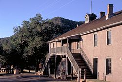
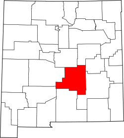
The community sits in the Bonito Valley between the Sacramento Mountains and the Capitan Mountains at an elevation of 5,696 feet. The village is located approximately 57 miles (92 km) west of Roswell (by road) and just north of the Lincoln National Forest. Lincoln is the primary community in zip code 88338, which had a population of 189 residents in the 2010 census. The village is centered around a 1 mile stretch of U.S. Route 380 (also known as the Billy the Kid Trail [1] ), which is the village's only street. Numerous historic structures dating as far back as the late 1800s still remain, many of which have been preserved and now operate as public museums.

Originally called La Placita del Rio Bonito (The Place by the Pretty River) by the Mexican families who settled it in the 1850s, the name of the community was changed to Lincoln when Lincoln County was created on January 16, 1869. Lincoln was at the center of the Lincoln County War, 1876-1879, and is primarily known today for its historical ties to Billy the Kid. The village holds an annual festival called Old Lincoln Days in August featuring an open-air enactment of The Last Escape of Billy the Kid. [2]

Lincoln has been Federally designated as the Lincoln Historic District, and also as a New Mexico State Monument called the Lincoln Historic Site. These designations, along with the efforts of generations of local residents, have made Lincoln one of the best preserved old west towns left in existence and the most visited monument in the State of New Mexico. [3]

For about a year during World War II, the Old Raton Ranch, an abandoned Civilian Conservation Corps camp on the outskirts of Lincoln, was used to confine Japanese American railroad workers and their families. All 32 internees came from Clovis, New Mexico; the town's entire Japanese American population was placed under house arrest shortly after the attack on Pearl Harbor brought the U.S. into the war, and the Immigration and Naturalization Service "evacuated" them to Lincoln on January 23, 1942. Unlike the "assembly centers" where most Japanese Americans spent the first months of their wartime incarceration, access to school, employment and recreational activities was not permitted in Lincoln. On December 18, 1942, the internees were transferred to several of the more public concentration camps run by the War Relocation Authority. [4] [5]

Tourism and entertainment

Food and lodging

The historic Wortley Hotel, once owned by Pat Garrett and central to the story of Billy the Kid, began serving guests in 1874 and still provides lodging to travelers. Lincoln also has a bar, the Bonito Valley Brewing Company, which serves a selection of locally brewed beer and non-alcoholic beverages. Annie's Little Sureshot Cafe serves coffee and snacks, and meals are served at the historic Dolan House.

Historic attractions

Lincoln has numerous historic structures, nine of which are open to the public as museums operated by New Mexico Historic Sites. These include the Courthouse where Billy the Kid killed deputies James W. Bell and Bob Olinger, the Tunstall Store, the Convento, the Torreon and others. The Anderson Freeman Visitor's Center has interpretive displays and artifacts that depict the history of Lincoln and the Bonito Valley.

Nearby attractions

See also

Related Research Articles

<span class="mw-page-title-main">Manzanar</span> World War II Japanese-American internment camp in California

Manzanar is the site of one of ten American concentration camps, where more than 120,000 Japanese Americans were incarcerated during World War II from March 1942 to November 1945. Although it had over 10,000 inmates at its peak, it was one of the smaller internment camps. The largest was the Tule Lake internment camp, located in northern California with a population of over 18,000 inmates. The smallest was Amanche, located southeastern Colorado, with over 7,000 inmates. It is located at the foot of the Sierra Nevada mountains in California's Owens Valley, between the towns of Lone Pine to the south and Independence to the north, approximately 230 miles (370 km) north of Los Angeles. Manzanar means "apple orchard" in Spanish. The Manzanar National Historic Site, which preserves and interprets the legacy of Japanese American incarceration in the United States, was identified by the United States National Park Service as the best-preserved of the ten former camp sites.

Sansei is a Japanese and North American English term used in parts of the world such as South America and North America to specify the children of children born to ethnic Japanese in a new country of residence. The nisei are considered the second generation; grandchildren of the Japanese-born immigrants are called Sansei; and the fourth generation is called yonsei. The children of at least one nisei parent are called Sansei and are usually the first generation of whom a high percentage are mixed race since their parents were usually themselves born and raised in America.

<span class="mw-page-title-main">Santa Fe Trail</span> 19th-century route through central North America between Franklin, MO, and Santa Fe, NM

The Santa Fe Trail was a 19th-century route through central North America that connected Franklin, Missouri, with Santa Fe, New Mexico. Pioneered in 1821 by William Becknell, who departed from the Boonslick region along the Missouri River, the trail served as a vital commercial highway until 1880, when the railroad arrived in Santa Fe. Santa Fe was near the end of El Camino Real de Tierra Adentro which carried trade from Mexico City. The trail was later incorporated into parts of the National Old Trails Road and U.S. Route 66.

<span class="mw-page-title-main">Fort Union National Monument</span> National monument in the United States

Fort Union National Monument is a unit of the National Park Service of the United States, and is located north of Watrous in Mora County, New Mexico. The national monument was founded on June 28, 1954.

<span class="mw-page-title-main">Minidoka National Historic Site</span> Historic site in Idaho, USA

Minidoka National Historic Site is a National Historic Site in the western United States. It commemorates the more than 13,000 Japanese Americans who were imprisoned at the Minidoka War Relocation Center during the Second World War. Among the inmates, the notation "峯土香" was sometimes applied.

<span class="mw-page-title-main">Amache National Historic Site</span> National Historic Site of the United States in Colorado

The Amache National Historic Site, formally the Granada War Relocation Center but known to the internees as Camp Amache, was a concentration camp for Japanese Americans in Prowers County, Colorado. Following the Japanese attack on Pearl Harbor on December 7, 1941, Japanese Americans on the West Coast were rounded up and sent to remote camps.Among the inmates, the notation "亜町" was sometimes applied.

<span class="mw-page-title-main">Topaz War Relocation Center</span> United States historic place

The Topaz War Relocation Center, also known as the Central Utah Relocation Center (Topaz) and briefly as the Abraham Relocation Center, was an American concentration camp that housed Americans of Japanese descent and immigrants who had come to the United States from Japan, called Nikkei. President Franklin Roosevelt signed Executive Order 9066 in February 1942, ordering people of Japanese ancestry to be incarcerated in what were euphemistically called "relocation centers" like Topaz during World War II. Most of the people incarcerated at Topaz came from the Tanforan Assembly Center and previously lived in the San Francisco Bay Area. The camp was opened in September 1942 and closed in October 1945.

<span class="mw-page-title-main">Fort Stanton</span> United States historic place

Fort Stanton was a United States Army fort near Lincoln, New Mexico.

San Patricio is a very small community in Lincoln County, in the U.S. state of New Mexico. It is located on the Rio Ruidoso and U.S. Highway 70, between the communities of Hondo and Glencoe. It is just east of the Lincoln National Forest.

<span class="mw-page-title-main">Lincoln Historic District (Lincoln, New Mexico)</span> Historic district in New Mexico, United States

Lincoln Historic District is a historic district encompassing the community of Lincoln, New Mexico. The district was added to the National Register of Historic Places in 1966. The historic district contains 48 structures, some privately held, 12 miles (19 km) east of Capitan and 57 miles (92 km) west of Roswell along U.S. Route 380.

<span class="mw-page-title-main">Raton Downtown Historic District</span> Historic district in New Mexico, United States

The Raton Downtown Historic District is a historic district listed on the National Register of Historic Places in Raton, New Mexico, USA. The district, when first listed in 1977, is bounded on the north by Clark Avenue and on the south by Rio Grande Avenue. On the east, the district is bounded by First Street, and on the west the district is bounded by Third Street. The district covers about 200 acres (81 ha) and contains 95 significant buildings. The district was enlarged in 2015.

<i>Nisei</i> Children of Japanese immigrants

Nisei is a Japanese-language term used in countries in North America and South America to specify the ethnically Japanese children born in the new country to Japanese-born immigrants. The Nisei are considered the second generation, and the grandchildren of the Japanese-born immigrants are called Sansei, or third generation.

Honouliuli National Historic Site is near Waipahu on the island of Oahu, in the U.S. state of Hawaii. This is the site of the Honouliuli Internment Camp which was Hawaiʻi's largest and longest-operating internment camp, opened in 1943 and closed in 1946. It was designated a National monument on February 24, 2015, by President Barack Obama. The John D. Dingell, Jr. Conservation, Management, and Recreation Act, signed March 12, 2019, redesignated it as Honouliui National Historic Site. The internment camp held 320 internees and also became the largest prisoner of war camp in Hawaiʻi with nearly 4,000 individuals being held. Of the seventeen sites that were associated with the history of internment in Hawaiʻi during World War II, the camp was the only one built specifically for prolonged detention. As of 2015, the new national monument is without formal services and programs.

<span class="mw-page-title-main">Trail of the Ancients</span> National Scenic Byways in Arizona, Colorado, New Mexico, and Utah, United States

The Trail of the Ancients is a collection of National Scenic Byways located in the U.S. Four Corners states of Utah, Colorado, New Mexico, and Arizona. These byways comprise:

<span class="mw-page-title-main">Bainbridge Island Japanese American Exclusion Memorial</span>

The Bainbridge Island Japanese American Exclusion Memorial is an outdoor exhibit commemorating the internment of Japanese Americans from Bainbridge Island in the state of Washington. It is located on the south shore of Eagle Harbor, opposite the town of Winslow. Administratively, it is a unit of the Minidoka National Historic Site in Idaho. The mission of the memorial is Nidoto Nai Yoni, “Let It Not Happen Again”.

The Civil War Trust's Civil War Discovery Trail is a heritage tourism program that links more than 600 U.S. Civil War sites in more than 30 states. The program is one of the White House Millennium Council's sixteen flagship National Millennium Trails. Sites on the trail include battlefields, museums, historic sites, forts and cemeteries.

<span class="mw-page-title-main">Organ Mountains–Desert Peaks National Monument</span>

The Organ Mountains–Desert Peaks National Monument is a United States national monument in the state of New Mexico, managed by the Bureau of Land Management as part of the National Landscape Conservation System.

<span class="mw-page-title-main">Placitas, Lincoln County, New Mexico</span> Historic village in New Mexico

Placitas, also known as La Placita and Las Placitas del Rio Bonito, in Lincoln County, New Mexico is a now abandoned village along the frontier between the New Mexico Territory and Confederate Arizona that was the site of the Battle of Placito, between Apache and native New Mexicans aided by Confederate soldiers from Fort Stanton, ten miles away to the north. The village was originally called La Placita del Rio Bonito, Placitas is now known as Lincoln. The village has historical ties to Billy the Kid.

References

  1. "Billy the Kid Trail - Map | America's Byways". www.fhwa.dot.gov. Retrieved 2019-06-26.
  2. Stallings, Dianne L (26 July 2018). "Ride into mayhem with Billy the Kid at Old Lincoln Days Aug. 3-5". Ruidoso News . Gannett . Retrieved 5 March 2019.
  3. "Lincoln Historic Site". New Mexico Historic Sites. Retrieved 2019-06-26.
  4. "Old Raton (detention facility)". Densho Encyclopedia . Retrieved 23 June 2014.
  5. Russell, Andrew B. (28 April 2008). "The Nikkei in New Mexico". Discover Nikkei . Japanese American National Museum. Retrieved 23 June 2014.