Corona, New Mexico

Last updated

Corona, New Mexico
Lincoln County New Mexico Incorporated and Unincorporated areas Corona Highlighted.svg
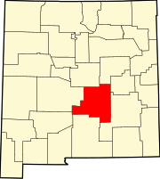
Location of Corona, New Mexico
Usa edcp location map.svg
Red pog.svg
Corona, New Mexico
Location in the United States
Coordinates: 34°15′2″N105°35′44″W / 34.25056°N 105.59556°W / 34.25056; -105.59556
Country United States
State New Mexico
County Lincoln
Area
[1]
  Total1.03 sq mi (2.66 km2)
  Land1.03 sq mi (2.66 km2)
  Water0.00 sq mi (0.00 km2)
Elevation
6,690 ft (2,039 m)
Population
 (2020) [2]
  Total129
  Density125.73/sq mi (48.54/km2)
Time zone UTC-7 (Mountain (MST))
  Summer (DST) UTC-6 (MDT)
ZIP code
88318
Area code 505
FIPS code 35-17680
GNIS feature ID0905356
Website http://www.villageofcorona.com

Corona is a village in Lincoln County, New Mexico, United States, located along U.S. Route 54. The population was 172 at the time of the 2010 census.

Contents

Description

Corona is the closest populated community to a purported UFO crash in 1947, approximately 30 miles (48 km) to the southeast. The rancher who found the crash first came to Corona to report it to a few residents, before going to Roswell to tell officials there.

In 2004, Corona was the site of a 4,000 acres (16 km2) forest fire, begun when an unknown arsonist lit a pile of pine needles.

Geography

Corona is located at 34°15′2″N105°35′44″W / 34.25056°N 105.59556°W / 34.25056; -105.59556 (34.250498, -105.595475). [3]

According to the United States Census Bureau, the village has a total area of 1.0 square mile (2.6 km2), all land.

Demographics

Historical population
CensusPop.Note
1950 530
1960 420−20.8%
1970 262−37.6%
1980 236−9.9%
1990 215−8.9%
2000 165−23.3%
2010 1724.2%
2020 129−25.0%
U.S. Decennial Census [4] [2]

At the 2000 census there were 165 people, 81 households, and 46 families in the village. The population density was 161.4 inhabitants per square mile (62.3/km2). There were 118 housing units at an average density of 115.4 per square mile (44.6/km2). The racial makeup of the village was 73.33% White, 3.64% Native American, 18.18% from other races, and 4.85% from two or more races. Hispanic or Latino of any race were 42.42%. [5]

Of the 81 households 23.5% had children under the age of 18 living with them, 44.4% were married couples living together, 8.6% had a female householder with no husband present, and 43.2% were non-families. 37.0% of households were one person and 14.8% were one person aged 65 or older. The average household size was 2.04 and the average family size was 2.61.

The age distribution was 20.6% under the age of 18, 6.1% from 18 to 24, 23.0% from 25 to 44, 30.3% from 45 to 64, and 20.0% 65 or older. The median age was 46 years. For every 100 females, there were 70.1 males. For every 100 females age 18 and over, there were 74.7 males.

The median household income was $28,594 and the median family income was $33,438. Males had a median income of $22,386 versus $14,375 for females. The per capita income for the village was $34,987. About 6.2% of families and 9.5% of the population were below the poverty line, including 20.8% of those under the age of eighteen and none of those sixty five or over.

See also

Related Research Articles

<span class="mw-page-title-main">Torrance County, New Mexico</span> County in New Mexico, United States

Torrance County is a county located in the center of the U.S. state of New Mexico. As of the 2020 census, the population was 15,045. The county seat is Estancia.

<span class="mw-page-title-main">Lincoln County, New Mexico</span> County in New Mexico, United States

Lincoln County is a county in the U.S. state of New Mexico. As of the 2020 census, the population was 20,269. Its county seat is Carrizozo, while its largest community is Ruidoso.

<span class="mw-page-title-main">Bluewater, California</span> Census-designated place in California, United States

Bluewater is a census-designated place (CDP) in San Bernardino County, California, United States. The population was 172 at the 2010 census, down from 265 at the 2000 census.

<span class="mw-page-title-main">Wells Township, Marquette County, Michigan</span> Civil township in Michigan, United States

Wells Township is a civil township of Marquette County in the U.S. state of Michigan. As of the 2020 census, the township population was 213.

<span class="mw-page-title-main">South Bend, Nebraska</span> Village in Nebraska, United States

South Bend is a village in Cass County, Nebraska, United States. The population was 92 at the 2020 census. The main landmark is a pedestrian bridge across the Platte River which leads to Schramm Park State Recreation Area. It was built in 2004 on the pillars of the abandoned Rock Island Railroad bridge. Thirty-five trains a day—most of them coal trains—still pass through the area on the BNSF Railway main.

<span class="mw-page-title-main">St. Helena, Nebraska</span> Village in Nebraska, United States

St. Helena is a village in Cedar County, Nebraska, United States. The population was 91 at the 2020 census.

<span class="mw-page-title-main">McCool Junction, Nebraska</span> Village in York County, Nebraska, United States

McCool Junction is a village in York County, Nebraska, United States. The population was 409 at the 2010 census.

<span class="mw-page-title-main">Loving, New Mexico</span> Village in New Mexico, United States

Loving is a village in Eddy County, New Mexico. As of the 2010 census, the village population was 1,413. Loving was settled by Swiss immigrants in the 1890s.

<span class="mw-page-title-main">Pecos, New Mexico</span> Village in New Mexico, United States

Pecos is a village in San Miguel County, New Mexico, United States. The population was 1,392 at the 2010 census, shrinking slower than other parts of San Miguel County, partly because Pecos is within commuting distance of Santa Fe. The village is built along the Pecos River, which flows from the north out of the Santa Fe National Forest. Notable locations nearby include Pecos National Historical Park, Glorieta Pass, Pecos Benedictine Monastery, and Lisboa Springs Trout Hatchery. It is also an entry point for hunting, fishing, hiking and camping in the Pecos Wilderness. The closest metropolitan area is the Santa Fe metropolitan area, approximately 26 miles (42 km) to the west.

<span class="mw-page-title-main">Cañada de los Alamos, New Mexico</span> CDP in New Mexico, United States

Cañada de los Alamos is a census-designated place (CDP) in Santa Fe County, New Mexico, United States. It is part of the Santa Fe, New Mexico Metropolitan Statistical Area. The population was 434 at the 2010 census.

<span class="mw-page-title-main">Chupadero, New Mexico</span> CDP in New Mexico, United States

Chupadero is a census-designated place (CDP) in Santa Fe County, New Mexico, United States. It is part of the Santa Fe, New Mexico Metropolitan Statistical Area. The population was 362 at the 2010 census.

<span class="mw-page-title-main">Cundiyo, New Mexico</span> CDP in New Mexico, United States

Cundiyo is a census-designated place (CDP) in Santa Fe County, New Mexico, United States. It is part of the Santa Fe, New Mexico Metropolitan Statistical Area. The population was 72 at the 2010 census. The name means round hill of the little bells in Tewa.

<span class="mw-page-title-main">Glorieta, New Mexico</span> CDP in New Mexico, United States

Glorieta is a census-designated place (CDP) in Santa Fe County, New Mexico, United States. It is part of the Albuquerque–Santa Fe–Las Vegas combined statistical area. The population was 430 at the 2010 census. The community is located in the southern Sangre de Cristo Mountains, along Interstate 25 on the east side of Glorieta Pass.

<span class="mw-page-title-main">Rio Chiquito, New Mexico</span> CDP in New Mexico, United States

Rio Chiquito is a census-designated place in Santa Fe County, New Mexico, United States. It is part of the Santa Fe, New Mexico Metropolitan Statistical Area. The population was 103 at the 2000 census.

<span class="mw-page-title-main">Encino, New Mexico</span> Village in New Mexico, United States

Encino is a village in Torrance County, New Mexico, United States. The population was 82 at the 2010 census. It is part of the Albuquerque Metropolitan Statistical Area.

<span class="mw-page-title-main">Willard, New Mexico</span> Village in New Mexico, United States

Willard is a village in Torrance County, New Mexico, United States. The population was 253 at the 2010 census. It is part of the Albuquerque Metropolitan Statistical Area. The village is not experiencing the same extreme growth that towns farther north in the state are. A wind farm has recently been constructed upon the mesa just south of the town. It provides power for about 25,000 homes in Arizona.

<span class="mw-page-title-main">Columbus, North Carolina</span> Town in North Carolina, United States

Columbus is a town in Polk County, North Carolina, United States. The population was 999 at the 2010 census. It is the county seat of Polk County.

<span class="mw-page-title-main">Walnutport, Pennsylvania</span> Place in Pennsylvania, United States

Walnutport is a borough in Northampton County, Pennsylvania. It was first incorporated in 1909. The population of Walnutport was 2,067 at the 2020 census.

<span class="mw-page-title-main">Oliver, Wisconsin</span> Village in Wisconsin, United States

Oliver is a village in Douglas County, Wisconsin, United States. The population was 423 at the 2020 census.

<span class="mw-page-title-main">Wilton, Wisconsin</span> Village in Wisconsin, United States

Wilton is a village in Monroe County, Wisconsin, United States. The population was 504 at the 2010 census. The village is located partially within the Town of Wilton and partially within the Town of Wellington.

References

  1. "ArcGIS REST Services Directory". United States Census Bureau. Retrieved October 12, 2022.
  2. 1 2 "Census Population API". United States Census Bureau. Retrieved October 12, 2022.
  3. "US Gazetteer files: 2010, 2000, and 1990". United States Census Bureau. February 12, 2011. Retrieved April 23, 2011.
  4. "Census of Population and Housing". Census.gov. Retrieved June 4, 2015.
  5. "U.S. Census website". United States Census Bureau . Retrieved January 31, 2008.