Riverside, New Mexico | |
|---|---|
 Riverside  Riverside | |
| Coordinates: 33°19′58″N105°03′37″W / 33.33278°N 105.06028°W | |
| Country | United States |
| State | New Mexico |
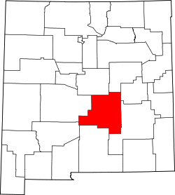
| County | Lincoln |
| Elevation | 4,754 ft (1,449 m) |
| Time zone | UTC-7 (Mountain (MST)) |
| • Summer (DST) | UTC-6 (MDT) |
| ZIP codes | 88343 |
| GNIS feature ID | 898592 |
Riverside is an unincorporated community in Lincoln County, New Mexico, in the southwestern United States. It is located along the Rio Hondo that flows east out of the Sacramento Mountains, the Sierra Blanca and the Capitan Mountains of south-central New Mexico. It is on combined routes U.S. 380 and U.S. 70, between the town of Lincoln and Roswell. [2] The nearest community is Sunset about a mile upstream. [2]