The Sangre de Cristo Range is a mountain range in the Rocky Mountains in southern Colorado in the United States, running north and south along the east side of the Rio Grande Rift. The mountains extend southeast from Poncha Pass for about 75 mi (121 km) through south-central Colorado to La Veta Pass, approximately 20 mi (32 km) west of Walsenburg, and form a high ridge separating the San Luis Valley on the west from the watershed of the Arkansas River on the east. The Sangre de Cristo Range rises over 7,000 ft (2,100 m) above the valleys and plains to the west and northeast.

Trinidad is the home rule municipality that is the county seat and the most populous municipality of Las Animas County, Colorado, United States. The population was 8,329 as of the 2020 census. Trinidad lies 21 mi (34 km) north of Raton, New Mexico, and 195 mi (314 km) south of Denver. It is on the historic Santa Fe Trail.

Española is a city primarily in Rio Arriba County, New Mexico, United States. A portion of the central and eastern section of the city is in Santa Fe County. Founded as a railroad village some distance from the old Indian town of San Juan de los Caballeros, it was named Española and officially incorporated in 1925. It has been called the first capital city in the United States. At the time of the 2010 census, the city had a total population of 10,495. Española is within the Albuquerque–Santa Fe–Los Alamos combined statistical area.

U.S. Route 285 is a north–south United States highway, running 846 miles (1,362 km) through the states of Texas, New Mexico and Colorado. The highway's southern terminus is in Sanderson, Texas at an intersection with U.S. Route 90. US 285 has always had an endpoint in Denver, Colorado, although the original US 285 went north from Denver. Today the highway's northern terminus is in Denver, at exit 201 on Interstate 25.

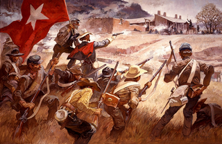
The Battle of Glorieta Pass was fought March 26–28, 1862 in the northern New Mexico Territory, by Union and Confederate forces during the American Civil War. While not the largest battle of the New Mexico campaign, the Battle of Glorieta Pass ended the Confederacy's efforts to capture the territory and other parts of the western United States.

Fort Union National Monument is a unit of the United States National Park Service located 7.7 miles north of Watrous in Mora County, New Mexico.

Ratón Pass is a 7,834 ft (2,388 m) elevation mountain pass on the Colorado–New Mexico border in the western United States. It is located on the eastern side of the Sangre de Cristo Mountains between Trinidad, Colorado and Raton, New Mexico, approximately 180 miles (290 km) northeast of Santa Fe. Ratón is Spanish for "mouse". The pass crosses the line of volcanic mesas that extends east from the Sangre de Cristo Mountains along the state line, and furnishes the most direct land route between the valley of the Arkansas River to the north and the upper valley of the Canadian River, leading toward Santa Fe, to the south. The pass now carries Interstate 25 and railroad tracks.

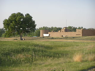
Bent's Old Fort is a fort located in Otero County in southeastern Colorado, United States. A company owned by Charles Bent and William Bent and Ceran St. Vrain built the fort in 1833 to trade with Southern Cheyenne and Arapaho Plains Indians and trappers for buffalo robes. For much of its 16-year history, the fort was the only major white American permanent settlement on the Santa Fe Trail between Missouri and the Mexican settlements. It was destroyed in 1849.

Ginery Twichell was president of the Boston and Worcester Railroad in the 1860s, the Republican Representative for Massachusetts for three consecutive terms and the sixth president of the Atchison, Topeka and Santa Fe Railway.

Railroad Wars were business rivalries between railroad companies, which occurred frequently in American history. Although they were usually little more than legal disputes inside a courtroom, they sometimes turned into armed conflicts. There has been competition between railroad companies since the beginning of railroading in the United States, but violent confrontations were most common in the final quarter of the 19th century, particularly in the Old West.

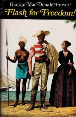
Flash for Freedom! is a 1971 novel by George MacDonald Fraser. It is the third of the Flashman novels.

Flashman and the Redskins is a 1982 novel by George MacDonald Fraser. It is the seventh of the Flashman novels.
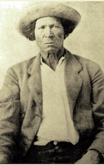
Thomas Tate Tobin was an American adventurer, tracker, trapper, mountain man, guide, US Army scout, and occasional bounty hunter. Tobin explored much of southern Colorado, including the Pueblo area. He associated with men such as Kit Carson, "Uncle Dick" Wootton, Ceran St. Vrain, Charley Bent, John C. Fremont, "Wild Bill" Hickok, William F. Cody, and the Shoup brothers. Tobin was one of only two men to escape alive from the siege of Turley's Mill and Distillery during the Taos Revolt. In later years he was sent by the Army to track down and kill the notorious Felipe Espinosa and his nephew; Tobin returned to Ft. Garland with their heads in a sack.

Otto Mears was a Colorado railroad builder and entrepreneur who played a major role in the early development of southwestern Colorado.

The Turquoise is a novel by the American author Anya Seton which was first published in 1946.

The Goodnight–Loving Trail was a trail used in the cattle drives of the late 1860s for the large-scale movement of Texas Longhorns. It is named after cattlemen Charles Goodnight and Oliver Loving.
A Spanish military fort was constructed and occupied in 1819 near Sangre de Cristo Pass in the present U.S. State of Colorado to protect the Spanish colony of Santa Fe de Nuevo México from a possible invasion from the United States. The fort was the only Spanish settlement in present-day Colorado. The site of this fort is known today as the Spanish Fort.

Charles Autobees (1812–1882), whose last name was also spelled Urtebise and Ortivis, was a fur trader and pioneer in the American Old West. He was the founder of Autobees, Colorado.

The history of slavery in Colorado began centuries before Colorado achieved statehood when Spanish colonists of Santa Fe de Nuevo México (1598–1848) enslaved Native Americans, called Genízaros. Southern Colorado was part of the Spanish territory until 1848. Comanche and Utes raided villages of other indigenous people and enslaved them.

Charlotte and Dick Green were enslaved African Americans who worked at Bent's Fort along the Santa Fe Trail in the southwestern frontier, in what is now Colorado. The couple and Dick's brother Andrew came to the fort with Charles and William Bent in the early 1800s and became key figures in the history of the trading post. Charlotte, also called "Black Charlotte", was known for her tasty food and fandango dancing. Dick Green was particularly well known for his role as a soldier, avenging the assassination of then Governor Charles Bent during the Taos Revolt. For his bravery, the Greens were freed and returned to Missouri.


