Abilene is a city in and the county seat of Dickinson County, Kansas, United States. As of the 2020 census, the population of the city was 6,460. It is home of The Dwight D. Eisenhower Presidential Library and Museum and the Greyhound Hall of Fame.

Pond Creek is a city in Grant County, Oklahoma, United States, along the Salt Fork Arkansas River. As of the 2010 census, the city population was 856, a 4.5 percent decline from the figure of 896 in 2000.
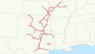
The Missouri–Kansas–Texas Railroad was a Class I railroad company in the United States, with its last headquarters in Dallas, Texas. Established in 1865 under the name Union Pacific Railroad (UP), Southern Branch, it came to serve an extensive rail network in Texas, Oklahoma, Kansas, and Missouri. In 1988, it merged with the Missouri Pacific Railroad; today, it is part of UP.

The Santa Fe Trail was a 19th-century route through central North America that connected Franklin, Missouri, with Santa Fe, New Mexico. Pioneered in 1821 by William Becknell, who departed from the Boonslick region along the Missouri River, the trail served as a vital commercial highway until 1880, when the railroad arrived in Santa Fe. Santa Fe was near the end of El Camino Real de Tierra Adentro which carried trade from Mexico City. The trail was later incorporated into parts of the National Old Trails Road and U.S. Route 66.

The Chisholm Trail was a trail used in the post-Civil War era to drive cattle overland from ranches in southern Texas, crossed the Red River into Indian Territory, and ended at Kansas rail stops. The trail encompassed a pathway established by Black Beaver in 1861, and a wagon road established by Jesse Chisholm around 1864. "The Chisholm Wagon Road went from Chisholm's trading post on the South Canadian (north of Fort Arbuckle to the Cimarron River crossing, to the Arkansas River at the future site of Wichita where Chisholm had another trading post and on north to Abilene," according to the Kraisingers. By 1869, the entire trail from Texas to Kansas became known as the Chisholm Trail.

The Missouri Pacific Railroad, commonly abbreviated as MoPac, was one of the first railroads in the United States west of the Mississippi River. MoPac was a Class I railroad growing from dozens of predecessors and mergers. In 1967, the railroad operated 9,041 miles of road and 13,318 miles of track, not including DK&S, NO&LC, T&P, and its subsidiaries C&EI and Missouri-Illinois.

The Cimarron River extends 698 miles (1,123 km) across New Mexico, Oklahoma, Colorado, and Kansas. The headwaters flow from Johnson Mesa west of Folsom in northeastern New Mexico. Much of the river's length lies in Oklahoma, where it either borders or passes through eleven counties. There are no major cities along its route. The river enters the Oklahoma Panhandle near Kenton, Oklahoma, crosses the corner of southeastern Colorado into Kansas, reenters the Oklahoma Panhandle, reenters Kansas, and finally returns to Oklahoma where it joins the Arkansas River at Keystone Reservoir west of Tulsa, Oklahoma, its only impoundment. The Cimarron drains a basin that encompasses about 18,927 square miles (49,020 km2).

The Cherokee Trail was a historic overland trail through the present-day U.S. states of Oklahoma, Kansas, Colorado, and Wyoming that was used from the late 1840s up through the early 1890s. The route was established in 1849 by a wagon train headed to the gold fields in California. Among the members of the expedition were a group of Cherokee. When the train formed in Indian Territory, Lewis Evans of Evansville, Arkansas, was elected Captain. Thus, this expedition is sometimes written as the Evans/Cherokee Train. In 1850 four wagon trains turned west on the Laramie Plains, along Wyoming's southern border to Fort Bridger.

Fort Gibson is a historic military site next to the modern city of Fort Gibson, in Muskogee County Oklahoma. It guarded the American frontier in Indian Territory from 1824 to 1888. When it was constructed, the fort was farther west than any other military post in the United States. It formed part of the north–south chain of forts that was intended to maintain peace on the frontier of the American West and to protect the southwestern border of the Louisiana Purchase. The fort succeeded in its peacekeeping mission for more than 50 years, as no massacres or battles occurred there.
The Abilene Trail was a cattle trail leading from Texas to Abilene, Kansas. Its exact route is disputed owing to its many offshoots, but it crossed the Red River just east of Henrietta, Texas, and continued north across the Indian Territory to Caldwell, Kansas and on past Wichita and Newton to Abilene. The first herds were probably driven over it in 1866, though it was not named until Abilene was established in 1867.

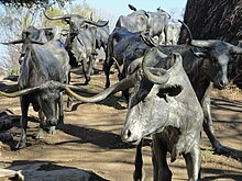
Cattle drives were a major economic activity in the 19th and early 20th century American West, particularly between 1850s and 1910s. In this period, 27 million cattle were driven from Texas to railheads in Kansas, for shipment to stockyards in St. Louis and points east, and direct to Chicago. The long distances covered, the need for periodic rests by riders and animals, and the establishment of railheads led to the development of "cow towns" across the frontier.

The Great Western Cattle Trail is the name used today for a cattle trail established during the late 19th century for moving beef stock and horses to markets in eastern and northern states. It ran west of and roughly parallel to the better known Chisholm Trail into Kansas, reaching an additional major railhead there for shipping beef to Chicago, or longhorns and horses continuing on further north by trail to stock open-range ranches in the Dakotas, Wyoming, Montana in the United States, and Alberta and Saskatchewan in Canada.
The timeline of Kansas details past events that happened in what is present day Kansas. Located on the eastern edge of the Great Plains, the U.S. state of Kansas was the home of sedentary agrarian and hunter-gatherer Native American societies, many of whom hunted American bison. The region first appears in western history in the 16th century at the time of the Spanish conquest of the Aztec Empire, when Spanish conquistadors explored the unknown land now known as Kansas. It was later explored by French fur trappers who traded with the Native Americans. It became part of the United States in the Louisiana Purchase of 1803. In the 19th century, the first American explorers designated the area as the "Great American Desert."
Preston Trail, later known as the Old Preston Road, was a road created by the Republic of Texas in 1841 from Preston, Texas on the Red River south to Austin, Texas. This road closely followed an existing trail that led across the area that had been used for centuries. This road was a main transportation artery from Central Texas to North Texas in the latter half of the 19th century. Today, Texas State Highway 289 follows near this former road.

According to the Encyclopedia of Oklahoma History and Culture, there were two trails that may have been known as the California Road at the time of the California Gold Rush. A southerly route, which ran through present-day Oklahoma, along the Canadian River. A northern route was usually called the California Trail.
Fort Washita is the former United States military post and National Historic Landmark located in Durant, Oklahoma on SH 199. Established in 1842 by General Zachary Taylor to protect citizens of the Choctaw and Chickasaw Nations from the Plains Indians, it was later abandoned by Federal forces at the beginning of the American Civil War. Confederate troops held the post until the end of the war when they burned the remaining structures. It was never reoccupied by the United States military. After years in private hands the Oklahoma Historical Society bought the fort grounds in 1962 and restored the site. In 2017, the Chickasaw Nation purchased Fort Washita from the Oklahoma Historical Society and assumed responsibility for the site and its management. Today, Fort Washita is a tourist attraction and hosts several events throughout the year. In August 2023, the Fort Washita Historic Site was placed into federal trust with the U.S. government.
Preston, also known as Preston Bend, is an unincorporated community and census-designated place located on the Red River in Grayson County, Texas, United States. It grew in the 19th century at the intersection of several military and trade roads and was an important crossing on the Shawnee cattle trail. Preston lost prominence after the MK&T railroad bypassed the town to the east, leading to a decline in traveler and cattle drive traffic. Much of its former town site is submerged beneath the waters of Lake Texoma. Its population was 2,096 as of the 2010 census.
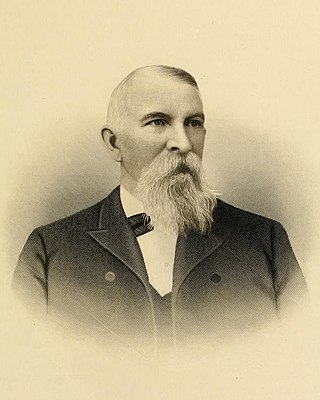
Nelson Story Sr. was a pioneer Montana entrepreneur, cattle rancher, miner and vigilante, who was a notable resident of Bozeman, Montana. He was best known for his 1866 cattle drive from Texas with approximately 1000 head of Texas Longhorns to Montana along the Bozeman Trail—the first major cattle drive from Texas into Montana. His business ventures in Bozeman were so successful that he became the town's first millionaire. In 1893, he played a prominent role in the establishment of the Agricultural College of the State of Montana by donating land and facilities. He built the first Story Mansion on Main Street in Bozeman in 1880 and later built today's Story Mansion at the corner of Willson and College for his son, T. Byron Story in 1910. In his later years, he became a prominent real estate developer in Los Angeles, California.

Black Beaver or Se-ket-tu-may-qua was a trapper and interpreter who worked for the American Fur Company. He served as a scout and guide as he was fluent in English, as well as several European and Native American languages. He is credited with establishing the California and Chisholm trails.
Montford T. Johnson (Chickasaw) was born and raised in Indian Territory. Johnson is known for becoming a successful entrepreneur after the Civil War. He developed a large ranching operation that spanned a large area of central Indian Territory along the Chisholm Trail, including parts of what would eventually develop as Oklahoma City.