Related Research Articles

Grayson County is a county in the U.S. state of Texas. As of the 2020 census, its population was 135,543. The county seat is Sherman. The county was founded in 1846 and is named after Peter Wagener Grayson, an attorney general of the Republic of Texas. Grayson County is included in the Sherman-Denison metropolitan statistical area, which is also included in the Dallas-Fort Worth-Arlington, combined statistical area. Located on the state's border with Oklahoma, it is part of the Texoma region, with proximity to Lake Texoma and the Red River.

Collin County is located in the U.S. state of Texas. It is part of the Dallas-Fort Worth-Arlington metropolitan statistical area, and a small portion of the city of Dallas is in the county. At the 2020 United States census, the county's population is 1,064,465, making it the sixth-most populous county in Texas and the 43rd-largest county by population in the United States. Its county seat is McKinney.

Frisco is a city in the U.S. state of Texas, located in Collin and Denton counties. It is part of the Dallas–Fort Worth metroplex (DFW) and about 25 miles (40 km) from both Dallas Love Field and Dallas/Fort Worth International Airport. Its population was 200,509 in the 2020 U.S. census.

North Texas is a term used primarily by residents of Dallas, Fort Worth Dallas–Fort Worth metroplex generally consider North Texas to include the area south of Oklahoma, east of Abilene, west of Paris, and north of Hillsboro. Definitions of the region usually don't include the sparsely populated Panhandle of Texas, which is the northernmost region of Texas bordered by New Mexico to the west and Oklahoma to the north and east.

Oliver Loving was an American rancher and cattle driver. Together with Charles Goodnight, he developed the Goodnight-Loving Trail. He was mortally wounded by Native Americans while on a cattle drive.

State Highway 121 is a state highway angling from southwest to northeast through north central Texas. It runs from Cleburne, Texas at US 67 to SH 78 in Bonham, Texas, just north of a junction with US 82.

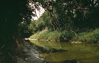
White Rock Creek is a 30 miles (48 km) creek occupying a chain of four sub-watersheds within the Trinity River watershed. From its source near Frisco, Texas at 33°07′54″N96°46′50″W, this creek runs south-by-south-east through suburban Dallas for 23.5 miles (37.8 km) where it widens into White Rock Lake, then continues south for another 8 miles (13 km) to its mouth on the Trinity River, of which it is a major tributary.
The Texas Road, also known as the Shawnee Trail, Sedalia Trail, or Kansas Trail, was a major trade and emigrant route to Texas across Indian Territory. Established during the Mexican War by emigrants rushing to Texas, it remained an important route across Indian Territory until Oklahoma statehood. The Shawnee Trail was the earliest and easternmost route by which Texas Longhorn cattle were taken to the north. It played a significant role in the history of Texas, Oklahoma, Missouri, and Kansas in the early and mid-1800s.

State Highway 289, known for most of its length as Preston Road, is a north–south Texas state highway. It begins at the intersection of Preston Road and Loop 12/Northwest Highway in Dallas. The Preston Road designation comes from the fact that the highway generally follows the course of an older road known as the Preston Trail, which ran to the town of Preston [Bend]. Preston is now submerged by Lake Texoma. The road is known as Preston all the way north through the remainder of the Dallas-Fort Worth Metroplex to a junction with State Highway 56 west of Sherman, near the Oklahoma state line. Preston Road passes through many of the fast-growing northern Dallas suburbs, including Frisco and Plano, as well as Prosper and Celina, with many new housing developments being built along Preston.

The Dallas North Tollway is a 30.2-mile (49 km) controlled-access toll road operated by the North Texas Tollway Authority (NTTA), which runs from Interstate 35E near Downtown Dallas, Texas (USA), to U.S. Highway 380, in Frisco, Texas. On December 20, 2023, the NTTA announced the Tollway's next extension which runs 6 miles (9.7 km) through Prosper and Celina and ends at FM 428.
Circle Ten Council is a Boy Scouts of America (BSA) chartered council in central north Texas and a portion of Oklahoma. It encompasses all or parts of: Camp, Collin, Dallas, Delta, Ellis, Fannin, Franklin, Grayson, Henderson, Hopkins, Hunt, Kaufman, Lamar, Morris, Navarro, Rains, Red River, Rockwall, Titus, and Van Zandt counties in Texas as well as Bryan, Choctaw, McCurtain, and Pushmataha counties in Oklahoma. Founded in 1913 and based in Dallas, approximately 34,000 youth and 7,800 adults participate in Scouting through the council each year. The council has four camps - Camp Wisdom, Camp James Ray, Clements Scout Ranch / Camp Trevor Rees-Jones and Camp Constantin / Jack D. Furst Aquatics Base. The Order of the Arrow is represented by Mikanakawa Lodge.
The history of Dallas, Texas, United States, from 1839 to 1855 concerns the city's original settlement and the establishment of Dallas County.
Lebanon was the name of two different communities that were founded in Texas in the 19th century, neither of which exist today. The first was a town located in Collin County that had a post office designated as Lebanon, Texas, before it was relocated to Frisco. The second was a smaller unincorporated community located in Live Oak County, of which only a cemetery remains today.
The Shawnee Trail was the white settlers' name for an American Indian trail in what is now eastern West Virginia, USA. It was a segment of the much larger Indian trail network known as the Great Indian Warpath, which stretched from New York to Alabama. The GIW was referred to from this point north as the "Seneca Trail". Thus, in pioneer days, the segment known as the Shawnee Trail was often also referred to as the Seneca Trail.
Preston, also known as Preston Bend, is an unincorporated community and census-designated place located on the Red River in Grayson County, Texas, United States. It grew in the 19th century at the intersection of several military and trade roads and was an important crossing on the Shawnee cattle trail. Preston lost prominence after the MK&T railroad bypassed the town to the east, leading to a decline in traveler and cattle drive traffic. Much of its former town site is submerged beneath the waters of Lake Texoma. Its population was 2,096 as of the 2010 census.

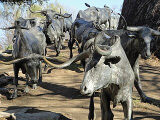
Pioneer Plaza is a large public park located in the Convention Center District of downtown Dallas, Texas (USA). It contains a large sculpture and is a heavily visited tourist site. Adjacent to the plaza is the Pioneer Park Cemetery which features the Confederate War Memorial. Together, it is the largest public open space in the Dallas central business district.
Christopher Columbus Slaughter (1837–1919) was an American rancher, cattle drover and breeder, banker and philanthropist in the Old West. After serving in the Confederate States Army during the American Civil War of 1861–1865, he came to own 40,000 cattle and over one million acres of ranch land in West Texas. He became the largest taxpayer in Texas, and used his wealth to endow Baptist institutions. He was known as the "Cattle King of Texas."
Orr Branch is a roughly 2-mile creek in the White Rock/Trinity River watershed in eastern Texas. From its uppermost source near the intersection of Tibbs and West Ricks Circle streets, it runs northeast through a portion of suburban Dallas until it flows into White Rock Creek and ultimately feeds into White Rock Lake.
Holland Coffee was an American trader, guide, interpreter, and representative of Fannin County. He was involved with the settlement of present-day Lake Texoma area and acted as a liaison between the native west and Caucasian settlers. Coffee was known chiefly for his trading and relations with Native American tribes such as the Comanches, Kiowa, Caddo, Wichita, and Delaware, and his many trading posts established in places such as Tillman, Love, and Cotton Counties. While Coffee was known for his prosperity, his land expansions brought along debt as well.

Stonewall Saloon or The Museum of the Stonewall Saloon is an authentic western saloon located in Saint Jo, Texas. The tavern was named as acknowledgment of Stonewall Jackson as American Civil War exiles appealed for sanctuary in what was termed "Indian country." The saloon was established in 1873 during the eminence of the cattle drive era exemplary of the late nineteenth century Old West.
References
- 1 2 3 Gard, Wayne (1956). "Retracing the Chisholm Trail". Southwestern Historical Quarterly. 60 (1): 53–68. JSTOR 30235278.
- ↑ Middlebrooks, Audy; Middlebrooks, Glenna (1965). "Holland Coffee of Red River". The Southwestern Historical Quarterly. 69 (2): 159.
- ↑ Britton, Morris L. (2014). "Coffee, Holland". Handbook of Texas Online. Denton, Texas: Texas State Historical Association. Retrieved 2014-01-11.
- 1 2 3 4 Gard, Wayne (1954). The Chisholm Trail. Norman, Oklahoma: University of Oklahoma Press. p. 296. ISBN 0-8061-1536-X.
- ↑ Cannon, Bill (2004). Texas: Land of Legend and Lore. Lanham, Maryland: Rowman & Littlefield. p. 205. ISBN 1-55622-949-6.
- ↑ Petersen, Paul (2007). Quantrill in Texas: The Forgotten Campaign. Cumberland House Publishing. p. 267. ISBN 9781581825824.
- ↑ Britton, Morris L (January 18, 2008). "Preston, Tx (Grayson County)". TSHA Handbook of Texas Online. Retrieved November 20, 2008.