Related Research Articles

The Allegheny River is a 325-mile-long (523 km) headwater stream of the Ohio River that is located in western Pennsylvania and New York in the United States. It runs from its headwaters just below the middle of Pennsylvania's northern border, northwesterly into New York, then in a zigzag southwesterly across the border and through Western Pennsylvania to join the Monongahela River at the Forks of the Ohio at Point State Park in Downtown Pittsburgh, Pennsylvania.

Randolph County is a county located in the U.S. state of West Virginia. As of the 2020 census, the population was 27,932. Its county seat is Elkins. The county was founded in 1787 and is named for Edmund Jennings Randolph.

The Allegheny Mountain Range, informally the Alleghenies, is part of the vast Appalachian Mountain Range of the Eastern United States and Canada and posed a significant barrier to land travel in less developed eras. The Allegheny Mountains have a northeast–southwest orientation, running for about 300 miles (480 km) from north-central Pennsylvania southward, through western Maryland and eastern West Virginia.

The Monongahela National Forest is a national forest located in the Allegheny Mountains of eastern West Virginia, USA. It protects over 921,000 acres of federally managed land within a 1,700,000 acres proclamation boundary that includes much of the Potomac Highlands Region and portions of 10 counties.

The Allegheny Front is the major southeast- or east-facing escarpment in the Allegheny Mountains in southern Pennsylvania, western Maryland, eastern West Virginia, and western Virginia. The Allegheny Front forms the boundary between the Ridge-and-Valley Appalachians to its east and the Appalachian Plateau to its west. The Front is closely associated with the Appalachian Mountains' Eastern Continental Divide, which in this area divides the waters of the Ohio/Mississippi river system, flowing to the Gulf of Mexico, from rivers flowing into Chesapeake Bay and from there into the Atlantic Ocean.

The Wilderness Road was one of two principal routes used by colonial and early national era settlers to reach Kentucky from the East. Although this road goes through the Cumberland Gap into southern Kentucky and northern Tennessee, the other is sometimes called the "Cumberland Road" because it started in Fort Cumberland in Maryland. Despite Kentucky Senator Henry Clay's advocacy of this route, early in the 19th century, the northern route was selected for the National Road, connecting near Washington, Pennsylvania into the Ohio Valley of northern Kentucky and Ohio.
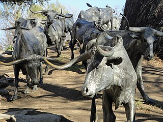
The Texas Road, also known as the Shawnee Trail, or Shawnee-Arbuckle Trail, was a major trade and emigrant route to Texas across Indian Territory. Established during the Mexican War by emigrants rushing to Texas, it remained an important route across Indian Territory until Oklahoma statehood. The Shawnee Trail was the earliest and easternmost route by which Texas Longhorn cattle were taken to the north. It played a significant role in the history of Texas, Oklahoma, Missouri, and Kansas in the early and mid-1800s.
Redstone Old Fort — or Redstone Fort or Fort Burd — on the Nemacolin Trail, was the name of the French and Indian War-era wooden fort built in 1759 by Pennsylvania militia colonel James Burd to guard the ancient Indian trail's river ford on a mound overlooking the eastern shore of the Monongahela River in what is now Fayette County, Pennsylvania, near, or on the banks of Dunlap's Creek at the confluence. The site is unlikely to be the same as an earlier fort the French document as Hangard dated to 1754 and which was confusedly, likely located on the nearby stream called Redstone Creek. Red sandstones predominate the deposited rock column of the entire region.

The South Branch Potomac River has its headwaters in northwestern Highland County, Virginia, near Hightown along the eastern edge of the Allegheny Front. After a river distance of 139 miles (224 km), the mouth lies east of Green Spring, Hampshire County, West Virginia, where it meets the North Branch Potomac River to form the Potomac.

The Tygart Valley River — also known as the Tygart River — is a principal tributary of the Monongahela River, approximately 135 miles (217 km) long, in east-central West Virginia in the United States. Via the Monongahela and Ohio rivers, it is part of the watershed of the Mississippi River, draining an area of 1,329 square miles (3,440 km2) in the Allegheny Mountains and the unglaciated portion of the Allegheny Plateau.
The Potomac Highlands of West Virginia centers on five West Virginian counties in the upper Potomac River watershed in the western portion of the state's Eastern Panhandle, bordering Maryland and Virginia. Because of geographical proximity, similar topography and landscapes, and shared culture and history, the Potomac Highlands region also includes Pocahontas, Randolph, and Tucker counties, even though they are in the Monongahela River or New River watersheds and not that of the Potomac River.

The Great Indian Warpath (GIW)—also known as the Great Indian War and Trading Path, or the Seneca Trail—was that part of the network of trails in eastern North America developed and used by Native Americans which ran through the Great Appalachian Valley. The system of footpaths extended from what is now upper New York to deep within Alabama. Various Native peoples traded and made war along the trails, including the Catawba, numerous Algonquian tribes, the Cherokee, and the Iroquois Confederacy. The British traders' name for the route was derived from combining its name among the northeastern Algonquian tribes, Mishimayagat or "Great Trail", with that of the Shawnee and Delaware, Athawominee or "Path where they go armed".

North Fork Mountain is a quartzite-capped mountain ridge in the Ridge and Valley physiographic province of the Allegheny Mountains, also known as the High Alleghenies or Potomac Highlands, of eastern West Virginia. Kile Knob, at 4,588 feet, is the mountain's highest point, and Panther Knob and Pike Knob are nearly as high.
Indian Old Field, or simply Old Field, was a common term used in Colonial American times and up until the early nineteenth century United States, by American explorers, surveyors, cartographers and settlers, in reference to land formerly cleared and utilized by indigenous or previous occupants for farming or occupation. The term appears in many old maps and land documents, often persisting for many decades. It also remains in a number of present-day place names of the Eastern US.

Germany Valley is a scenic upland valley high in the Allegheny Mountains of eastern West Virginia originally settled by German farmers in the mid-18th century. It is today a part of the Spruce Knob–Seneca Rocks National Recreation Area of the Monongahela National Forest, although much ownership of the Valley remains in private hands.

Waterways in West Virginia find their highest sources in the highland watersheds of the Allegheny Mountains. These watersheds supply drainage to the creeks often passing through deep and narrow hollows. From the hollows, rushing highland streams collect in bottom land brooks and rivers. People have lived along and boated on the waterways of what is now the Mountain State from the time of antiquity.
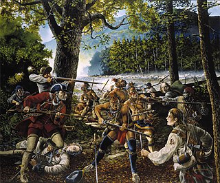
The Battle of the Trough was a skirmish of the early French and Indian War (1754–63) fought between Native Americans and Anglo-American settlers in the valley of the South Branch Potomac River in what is now northern Hardy County, West Virginia, USA.

Big Run is a river of 13 miles in length, located one-and-a-half miles west of Spruce Knob in Monongahela National Forest, in Pendleton County, West Virginia. It is a tributary of the North Fork South Branch Potomac River.
References
- ↑ Compton, Ralph (1994), The Shawnee trail , St Martin's Paperbacks, ISBN 978-0-312-95241-9
- ↑ "Neglected historic Shawnee Trail starts to get recognized", Dallas Morning News (Dallas, TX), McClatchy-Tribune Information Services, 2009-12-26, retrieved 1 December 2018
- ↑ Callahan, James Morton (1923), The History of West Virginia, Old and New, Vol. I, pg. 66-79.
- ↑ Richard Ellsworth Fast, Hu Maxwell (1901). The History and Government of West Virginia. The Acme Publishing Company. pp. 14.
- ↑ Callahan, Op. cit.