Fort Sumner, New Mexico

Last updated

Fort Sumner, New Mexico
Ft sumner nm.jpg
Downtown Fort Sumner in 2003
DeBaca County New Mexico Incorporated and Unincorporated areas Fort Sumner Highlighted.svg
Location of Fort Sumner, New Mexico
Usa edcp location map.svg
Red pog.svg
Fort Sumner, New Mexico
Location in the United States
Coordinates: 34°28′33″N104°14′53″W / 34.47583°N 104.24806°W / 34.47583; -104.24806
CountryUnited States
State New Mexico
County De Baca
Area
[1]
  Total3.35 sq mi (8.66 km2)
  Land3.31 sq mi (8.58 km2)
  Water0.03 sq mi (0.08 km2)
Elevation
[2]
4,045 ft (1,233 m)
Population
 (2020) [3]
  Total889
  Estimate 
(2023)
863
  Density268.17/sq mi (103.56/km2)
Time zone UTC−7 (Mountain (MST))
  Summer (DST) UTC−6 (MDT)
ZIP code
88119
Area code 575
FIPS code 35-27340
GNIS feature ID2413553 [2]

Fort Sumner is a village in and the county seat of De Baca County, New Mexico, United States. [4] The population was 1,031 at the 2010 U.S. Census, [5] down from the figure of 1,249 recorded in 2000. Fort Sumner is the spring and fall home of the Columbia Scientific Balloon Facility.

Contents

History

Named after former New Mexico Territory military governor Edwin Vose Sumner, U.S. Fort Sumner was a military fort established in 1862 and charged with the internment of nearby Navajo and Mescalero Apache populations from 1863 to 1868. The federal government closed the fort in 1868 and sold its buildings to Lucien Maxwell, a prominent New Mexico landowner, in 1870. [6] In the latter 1870s Maxwell's son Pete befriended legendary outlaw Billy the Kid, [7] and it was in his house that Billy was killed by Pat Garrett. [8] Billy the Kid is buried in the old military cemetery in Fort Sumner, [9] as is Lucien Maxwell. [10]

In 1866, the U.S. government was holding thousands of Native American Indians at Fort Sumner after they were subdued by Kit Carson. Charles Goodnight and Oliver Loving saw a business opportunity and decided to sell beef to the United States Government so that the captive, displaced, and imprisoned Native Americans could be fed. This enterprise led to the establishment of the Goodnight-Loving Trail.

In March 1908, the Eastern Railway of New Mexico (as subsidiary of the Atchison, Topeka and Santa Fe Railway) arrived as part of the Belen Cutoff; [11] now BNSF.

In the 1920s the Transcontinental Air Transport airline built an airfield in Fort Sumner as part of its coast-to-coast air passenger network, but the site was abandoned when the airline's ambitious plans collapsed in the Great Depression. The airfield was reopened by the United States Army Air Forces as a training base during World War II. After the war, the base became the Fort Sumner Municipal Airport, and was chosen as a launch site for NASA's high-altitude balloon program (see Columbia Scientific Balloon Facility).

Geography

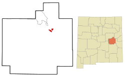
Fort Sumner is located northeast of the center of De Baca County on the north side of the Pecos River.

U.S. Route 60 passes through the village as Sumner Avenue, leading east 61 miles (98 km) to Clovis [12] and west 58 miles (93 km) to Vaughn. [13] U.S. Route 84 comes in from the north as 4th Street, leading northwest 44 miles (71 km) to Santa Rosa. US 84 runs east from Fort Sumner with US 60 to Clovis and the Texas border beyond it.

Climate

According to the United States Census Bureau, the village of Fort Sumner has a total area of 3.34 square miles (8.66 km2), of which 3.31 square miles (8.58 km2) is land and 0.03 square miles (0.08 km2), or 0.93%, is water. [5]

Climate data for Fort Sumner, New Mexico (1981–2010)
MonthJanFebMarAprMayJunJulAugSepOctNovDecYear
Mean daily maximum °F (°C)56.3
(13.5)
60.8
(16.0)
68.5
(20.3)
77.5
(25.3)
85.7
(29.8)
95.3
(35.2)
94.4
(34.7)
92.4
(33.6)
86.4
(30.2)
76.1
(24.5)
64.6
(18.1)
55.7
(13.2)
76.1
(24.5)
Mean daily minimum °F (°C)22.3
(−5.4)
26.2
(−3.2)
33.7
(0.9)
39.7
(4.3)
50.7
(10.4)
60.5
(15.8)
64.3
(17.9)
62.9
(17.2)
55.3
(12.9)
42.7
(5.9)
29.1
(−1.6)
23.0
(−5.0)
42.5
(5.8)
Average precipitation inches (mm)0.42
(11)
0.41
(10)
0.70
(18)
0.86
(22)
1.30
(33)
1.60
(41)
2.18
(55)
3.22
(82)
1.74
(44)
1.57
(40)
0.66
(17)
0.60
(15)
15.25
(387)
Average snowfall inches (cm)4.1
(10)
2.9
(7.4)
1.0
(2.5)
0.5
(1.3)
0.0
(0.0)
0.0
(0.0)
0.0
(0.0)
0.0
(0.0)
0.0
(0.0)
0.1
(0.25)
1.5
(3.8)
4.9
(12)
15.0
(38)
Source: NOAA [14]

Demographics

Historical population
CensusPop.Note
1920 777
1930 8398.0%
1940 1,66998.9%
1950 1,98218.8%
1960 1,809−8.7%
1970 1,615−10.7%
1980 1,421−12.0%
1990 1,269−10.7%
2000 1,249−1.6%
2010 1,031−17.5%
2020 889−13.8%
U.S. Decennial Census [15] [3]
Along U.S. Route 84 in Fort Sumner Ft Sumner.jpg
Along U.S. Route 84 in Fort Sumner

As of the census [16] of 2000, there were 1,249 people, 533 households, and 312 families residing in the village. The population density was 374.6 people per square mile (144.6 people/km2). There were 680 housing units at an average density of 204.0 per square mile (78.8/km2). The racial makeup of the village was 81.91% White, 0.80% Native American, 0.08% Asian, 15.29% from other races, and 1.92% from two or more races. Hispanic or Latino of any race were 48.28% of the population.

There were 533 households, out of which 22.9% had children under the age of 18 living with them, 45.8% were married couples living together, 9.4% had a female householder with no husband present, and 41.3% were non-families. 38.6% of all households were made up of individuals, and 23.3% had someone living alone who was 65 years of age or older. The average household size was 2.21 and the average family size was 2.97.

In the village, the population was spread out, with 22.4% under the age of 18, 5.6% from 18 to 24, 21.2% from 25 to 44, 19.5% from 45 to 64, and 31.3% who were 65 years of age or older. The median age was 46 years. For every 100 females, there were 92.4 males. For every 100 females age 18 and over, there were 86.3 males.

The median income for a household in the village was $19,583, and the median income for a family was $28,625. Males had a median income of $24,722 versus $16,953 for females. The per capita income for the village was $13,327. About 20.4% of families and 25.3% of the population were below the poverty line, including 33.9% of those under age 18 and 17.1% of those age 65 or over.

Education

Fort Sumner Municipal Schools is the school district of all of De Baca County. [17]

See also

Related Research Articles

<span class="mw-page-title-main">Hamilton County, Texas</span> County in Texas, United States

Hamilton County is a county located on the Edwards Plateau in the U.S. state of Texas. As of the 2020 census, its population was 8,222. The county seat is Hamilton. The county was created in 1858. It is named for James Hamilton Jr., a former governor of South Carolina who gave financial aid to the Republic of Texas.

<span class="mw-page-title-main">Roosevelt County, New Mexico</span> County in New Mexico, United States

Roosevelt County is a county located in the U.S. state of New Mexico. As of the 2020 census, the population was 19,191. Its county seat is Portales. The county was created in 1903 from Chaves and Guadalupe counties and named for the then-current President of the United States, Theodore Roosevelt. The county's eastern border is the Texas state line.

<span class="mw-page-title-main">McKinley County, New Mexico</span> County in New Mexico, United States

McKinley County is a county in the northwestern section of the U.S. state of New Mexico. As of the 2020 United States Census, its population was 72,902. Its county seat is Gallup. The county was created in 1901 and named for President William McKinley.

<span class="mw-page-title-main">Lincoln County, New Mexico</span> County in New Mexico, United States

Lincoln County is a county in the U.S. state of New Mexico. As of the 2020 census, the population was 20,269. Its county seat is Carrizozo, while its largest community is Ruidoso.

<span class="mw-page-title-main">Curry County, New Mexico</span> County in New Mexico, United States

Curry County is a county located in the U.S. state of New Mexico. As of the 2020 census, its population was 48,430. Its county seat is Clovis. The county is named in honor of George Curry, territorial governor of New Mexico from 1907 to 1910.

<span class="mw-page-title-main">Chaves County, New Mexico</span> County in New Mexico, United States

Chaves County is a county in New Mexico, United States. As of the 2020 census, the population was 65,157. Its county seat is Roswell. Chaves County was named for Colonel Jose Francisco Chaves, a military leader there during the Civil War and later in Navajo campaigns. The county was created by the New Mexico Territorial Legislature on February 25, 1889, out of land from Lincoln County.

<span class="mw-page-title-main">Catron County, New Mexico</span> County in New Mexico, United States

Catron County is a county in the U.S. state of New Mexico. As of the 2020 census, the population was 3,579, making it New Mexico's third-least populous county. Its county seat is Reserve. Catron County is New Mexico's largest county by area.

<span class="mw-page-title-main">Sumner County, Kansas</span> County in Kansas, United States

Sumner County is a county located in the U.S. state of Kansas. Its county seat is Wellington. As of the 2020 census, the population was 22,382. The county is named after Charles Sumner, a U.S. Senator from Massachusetts who was a leader of Reconstruction politics.

<span class="mw-page-title-main">Baca County, Colorado</span> County in Colorado, United States

Baca County is a county located in the U.S. state of Colorado. As of the 2020 census, the population was 3,506. The county seat is Springfield. Located at the southeast corner of Colorado, the county shares state borders with Kansas, New Mexico, and Oklahoma.

<span class="mw-page-title-main">Fort Defiance, Arizona</span> CDP in Apache County, Arizona

Fort Defiance is a census-designated place (CDP) in Apache County, Arizona, United States. It is also located within the Navajo Nation. The population was 3,624 at the 2010 census.

<span class="mw-page-title-main">Maxwell, New Mexico</span> Village in New Mexico, United States

Maxwell is a village in Colfax County, New Mexico, United States. The population was 254 at the 2010 census, down from 274 in 2000. Maxwell was established in 1879 as a railroad town on the Atchison, Topeka and Santa Fe Railway. It was named in honor of Lucien Maxwell, who provided the land for the original townsite from his Maxwell Land Grant.

<span class="mw-page-title-main">Clovis, New Mexico</span> City in the United States

Clovis is a city in and the county seat of Curry County, New Mexico. The population was 38,567 at the 2020 census. Clovis is located in the New Mexico portion of the Llano Estacado, in the eastern part of the state.

<span class="mw-page-title-main">Lake Sumner, New Mexico</span> Census-designated place in De Baca County, New Mexico, United States

Lake Sumner is a census-designated place (CDP) in De Baca County, New Mexico, United States. The population was 143 at the 2010 census, up from the figure of 86 recorded in 2000.

<span class="mw-page-title-main">Mesilla, New Mexico</span> Town in New Mexico, United States

Mesilla is a town in Doña Ana County, New Mexico, United States. The population was 2,196 at the 2010 census. It is part of the Las Cruces Metropolitan Statistical Area.

<span class="mw-page-title-main">Santa Clara, New Mexico</span> Village in New Mexico, United States

Santa Clara is a village in Grant County, New Mexico, United States. The population was 1,686 at the 2010 census, down from 1,944 in 2000. Today it is a bedroom community for nearby Silver City.

<span class="mw-page-title-main">Santa Rosa, New Mexico</span> City in New Mexico, United States

Santa Rosa is a city in and the county seat of Guadalupe County, New Mexico, United States. The population was 2,848 at the 2010 census. It lies between Albuquerque and Tucumcari, situated on the Pecos River at the intersection of Interstate 40 and U.S. Route 54 and 84. The city is located on the western edge of the Llano Estacado or "staked plains" of eastern New Mexico and west Texas.

<span class="mw-page-title-main">Wagon Mound, New Mexico</span> Village in New Mexico, United States

Wagon Mound is a village in Mora County, New Mexico, United States. It is named after and located at the foot of a butte called Wagon Mound, which was a landmark for covered wagon trains and traders going up and down the Santa Fe Trail and is now Wagon Mound National Historic Landmark. It was previously an isolated ranch that housed four families that served as local traders. The shape of the mound is said to resemble a Conestoga wagon. As of the 2010 census, the village population was 314. It was also called Santa Clara for many years. The village, with brightly painted houses and several stores and shops, is located on the plains of northeastern New Mexico. Interstate 25, which skirts the western side of town, gives a view of the majority of the town. Wagon Mound is not growing rapidly, but it has seen new construction along I-25, with new buildings on the northeast side of town as well.

<span class="mw-page-title-main">Socorro, New Mexico</span> City in New Mexico, United States

Socorro is a city in Socorro County in the U.S. state of New Mexico. It is in the Rio Grande Valley at an elevation of 4,579 feet (1,396 m). In 2010 the population was 9,051. It is the county seat of Socorro County. Socorro is located 74 miles (119 km) south of Albuquerque and 146 miles (235 km) north of Las Cruces.

<span class="mw-page-title-main">Fort Sumner</span> United States historic place

Fort Sumner was a military fort in New Mexico Territory charged with the internment of Navajo and Mescalero Apache populations from 1863 to 1868 at nearby Bosque Redondo.

<span class="mw-page-title-main">De Baca County, New Mexico</span> County in New Mexico, United States

De Baca County is a county in the U.S. state of New Mexico. As of the 2020 census, the population was 1,698, making it New Mexico's second-least populous county. Its county seat is Fort Sumner. The county is named for Ezequiel Cabeza De Baca, the second elected Governor of New Mexico.

References

  1. "ArcGIS REST Services Directory". United States Census Bureau. Retrieved October 12, 2022.
  2. 1 2 U.S. Geological Survey Geographic Names Information System: Fort Sumner, New Mexico
  3. 1 2 "Census Population API". United States Census Bureau. Retrieved October 12, 2022.
  4. "Find a County". National Association of Counties. Archived from the original on May 31, 2011. Retrieved June 7, 2011.
  5. 1 2 "Geographic Identifiers: 2010 Demographic Profile Data (G001): Fort Sumner village, New Mexico". U.S. Census Bureau, American Factfinder. Archived from the original on February 13, 2020. Retrieved November 3, 2015.
  6. Pearce, T.M.,editor, New Mexico Place Names, A Geographical Dictionary, University of New Mexico Press 1965. ISBN   0-8263-0082-0
  7. "Three Friends of Billy the Kid". Angelfire . Retrieved January 12, 2019.
  8. "Billy the Kid is shot to death". History.com . A&E Television Networks. November 13, 2009. Retrieved December 13, 2018.
  9. Conradt, Stacy (July 15, 2016). "Why Billy the Kid's Tombstone Says 'Pals'". Mental Floss . Retrieved January 12, 2019.
  10. Keleher, William Aloysius (1983). Maxwell Land Grant: A New Mexico Item. University of New Mexico Press. p. 37. ISBN   9780826306784.
  11. Myrick, David, ‘’New Mexico’s Railroads, A Historic Survey’’, University of New Mexico Press 1990. ISBN   0-8263-1185-7
  12. "Distance from Fort Sumner to Clovis". distances.io. Retrieved June 10, 2010.
  13. "Distance from Fort Sumner to Vaughn". distances.io. Retrieved June 10, 2010.
  14. "NOWData - NOAA Online Weather Data". National Oceanic and Atmospheric Administration . Retrieved May 5, 2013.
  15. "Census of Population and Housing". Census.gov. Retrieved June 4, 2015.
  16. "U.S. Census website". United States Census Bureau . Retrieved January 31, 2008.
  17. "2020 CENSUS - SCHOOL DISTRICT REFERENCE MAP: De Baca County, NM" (PDF). U.S. Census Bureau . Retrieved January 20, 2023. - Clipping from Newspapers.com.
  18. O'Dell, Ron (March 18, 2016). "ATS Real Logos Project". Steam Community . Valve . Retrieved October 13, 2018.