Tierra Amarilla, New Mexico

Last updated

Tierra Amarilla, New Mexico
Rio Arriba CCH.jpg
Rio Arriba County Courthouse, Isaac Rapp, 1916-17
USA New Mexico location map.svg
Red pog.svg
Tierra Amarilla
Location within the state of New Mexico
Usa edcp location map.svg
Red pog.svg
Tierra Amarilla
Tierra Amarilla (the United States)
Coordinates: 36°42′22″N106°33′35″W / 36.70611°N 106.55972°W / 36.70611; -106.55972 [1]
CountryUnited States
State New Mexico
County Rio Arriba
Area
[2]
  Total2.69 sq mi (6.98 km2)
  Land2.69 sq mi (6.96 km2)
  Water0.01 sq mi (0.01 km2)
Elevation
[1]
7,487 ft (2,282 m)
Population
 (2020) [3]
  Total297
  Density110.49/sq mi (42.65/km2)
Time zone UTC−7 (MST)
  Summer (DST) UTC−6 (MDT)
ZIP code
87575
Area code 575
FIPS code 35-77670
GNIS feature ID2584225 [1]
Website www.sangres.com/newmexico/rioarriba/tierraamarilla.htm

Tierra Amarilla is a census-designated place in and the county seat of Rio Arriba County, New Mexico, United States. [1] [4]

Contents

Tierra Amarilla is Spanish for "Yellow Earth". The name refers to clay deposits found in the Chama River Valley and used by Native American peoples. [5] :352–353 [6] Tewa and Navajo toponyms for the area also refer to the yellow clay. [5] :352–353

History

There is evidence of 5000 years of habitation in the Chama River Valley including pueblo sites south of Abiquiu. The area served as a trade route for peoples in the present-day Four Corners region and the Rio Grande Valley. Navajos later used the valley as a staging area for raids on Spanish settlements along the Rio Grande. Written accounts of the Tierra Amarilla locality by pathfinding Spanish friars in 1776 described it as suitable for pastoral and agricultural use. The route taken by the friars from Santa Fe to California became the Spanish Trail. During the Californian Gold Rush the area became a staging point for westward fortune seekers. [7]

Tierra Amarilla Grant

The Tierra Amarilla Land Grant was created in 1832 by the Mexican government for Manuel Martinez and settlers from Abiquiu. [5] :352–353 [6] The land grant encompassed a more general area than the contemporary community known as Tierra Amarilla. [5] :352–353 The grant holders were unable to maintain a permanent settlement due to "raids by Utes, Navajos and Jicarilla Apaches" until early in the 1860s. [6] In 1860 the United States Congress confirmed the land grant as a private grant, rather than a community grant, due to mistranslated and concealed documents. [8] Although a land patent for the grant required the completion of a geographical survey before issuance, some of Manuel Martinez' heirs began to sell the land to Anglo speculators. In 1880 Thomas Catron sold some of the grant to the Denver and Rio Grande Railway for the construction of their San Juan line and a service center at Chama. By 1883 Catron had consolidated the deeds he held for the whole of the grant sans the original villages and their associated fields. In 1950, the descendants of the original grant holders' court petitions to reclaim communal land were rebuked. [8]

Rio Arriba's county seat

In 1866 the United States Army established Camp Plummer just south of Los Ojos (established in 1860) to rein in already decreased Native American activity on the grant. The military encampment was deserted in 1869. [5] :57,210,352–353 Las Nutrias, the site of the contemporary community, was founded nearby c.1862. The first post office in Las Nutrias was established in 1866 and bore the name Tierra Amarilla, as did the present one which was established in 1870 after an approximately two-year absence. [5] :352–353 In 1877 a U.S. Army lieutenant described the village as "the center of the Mexican population of northwestern New Mexico". [6] The territorial legislature located Rio Arriba's county seat in Las Nutrias and renamed the village in 1880. [5] :352–353 The Denver and Rio Grande Railway's 1881 arrival at Chama, [9] about ten miles to the north, had profound effects on the development of the region by bringing the area out of economic and cultural isolation. [8]

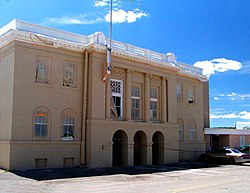
When Tierra Amarilla was designated as the county seat the villagers set about building a courthouse. [6] This structure was demolished to make way for the present one, which was built in 1917 and gained notoriety fifty years later when it was the location of a gunfight between land rights activists and authorities. [10] The neoclassical design by Isaac Rapp is now on the National Register of Historic Places. [11]

Courthouse raid

The Alianza Federal de Mercedes, led by Reies Tijerina, raided the Rio Arriba County Courthouse in 1967. Attempting to make a citizen's arrest of the district attorney "to bring attention to the unscrupulous means by which government and Anglo settlers had usurped Hispanic land grant properties," an armed struggle in the courthouse ensued resulting in Tijerina and his group fleeing to the south with two prisoners as hostages. Eulogio Salazar, a prison guard, was shot and Daniel Rivera, a sheriff's deputy, was badly injured. The National Guard, FBI and New Mexico State Police successfully pursued Tijerina, who was sentenced to less than three years. [6]

Geography

The Brazos Cliffs are a prominent nearby landmark and attraction. Also nearby are the artificial Heron Lake and El Vado Lake. Tierra Amarilla's elevation is 7,524 feet above sea level.

Layout

The settlement is situated in a cluster of villages along U.S. Route 84 and the Chama River. [6] The layout of the villages, including the one that became Tierra Amarilla, do not follow the urban planning principles of the Laws of the Indies. [7]

Climate

Tierra Amarilla has a humid continental climate (Köppen Dfb) with very cold, snowy, though generally sunny winters, and summers featuring very warm to hot afternoons and cold to cool mornings. During the winter, mornings are frigid, with as many as 26.7 falling to or below 0 °F or −17.8 °C, although maxima top freezing on all but nineteen afternoons during an average winter. The coldest temperature has been −39 °F (−39.4 °C) on January 6, 1971. Snowfall is much heavier than in more populated parts of New Mexico as Tierra Amarilla is located on a western slope rather than in a valley: the annual average is 62.2 inches or 1.58 metres with a maximum of 55.9 inches (1.42 m) in January 1997 and a maximum annual total of 125.5 inches (3.19 m) between July 1996 and June 1997. The maximum snow depth has been 44 inches or 1.12 metres on 30 November 1983.

The spring season sees the sunniest weather of all and steadily warming temperatures, although over the year as a whole 224.9 mornings fall to or below freezing, with four freezes to be expected as late as June. The summer, although seeing diurnal temperature ranges of over 34 °F or 18.9 °C, is the wettest period due to frequent monsoonal thunderstorms. The wettest months have been September 1927 and August 1967 which each saw 5.96 inches (151.4 mm) of precipitation, the wettest calendar year 1986 with 24.85 inches (631.2 mm), and the driest 1956 with 8.63 inches (219.2 mm).

Climate data for Tierra Amarilla 4 N, New Mexico, 1991–2020 normals, 1927-2020 extremes: 7464ft (2275m)
MonthJanFebMarAprMayJunJulAugSepOctNovDecYear
Record high °F (°C)60
(16)
65
(18)
74
(23)
80
(27)
91
(33)
95
(35)
102
(39)
97
(36)
90
(32)
85
(29)
72
(22)
66
(19)
102
(39)
Mean maximum °F (°C)54.1
(12.3)
55.6
(13.1)
64.0
(17.8)
70.7
(21.5)
80.5
(26.9)
87.3
(30.7)
91.3
(32.9)
88.7
(31.5)
82.7
(28.2)
75.5
(24.2)
63.5
(17.5)
53.5
(11.9)
90.2
(32.3)
Mean daily maximum °F (°C)40.2
(4.6)
43.3
(6.3)
51.2
(10.7)
58.8
(14.9)
68.1
(20.1)
79.5
(26.4)
83.3
(28.5)
80.9
(27.2)
73.9
(23.3)
62.5
(16.9)
50.4
(10.2)
40.0
(4.4)
61.0
(16.1)
Daily mean °F (°C)22.9
(−5.1)
26.6
(−3.0)
34.7
(1.5)
41.5
(5.3)
49.7
(9.8)
58.9
(14.9)
64.8
(18.2)
63.2
(17.3)
55.7
(13.2)
44.7
(7.1)
33.6
(0.9)
23.9
(−4.5)
43.4
(6.3)
Mean daily minimum °F (°C)5.7
(−14.6)
9.8
(−12.3)
18.2
(−7.7)
24.2
(−4.3)
31.3
(−0.4)
38.3
(3.5)
46.3
(7.9)
45.5
(7.5)
37.5
(3.1)
26.8
(−2.9)
16.8
(−8.4)
7.8
(−13.4)
25.7
(−3.5)
Mean minimum °F (°C)−10.3
(−23.5)
−8.0
(−22.2)
1.9
(−16.7)
12.4
(−10.9)
21.8
(−5.7)
28.8
(−1.8)
37.7
(3.2)
38.7
(3.7)
25.9
(−3.4)
14.3
(−9.8)
0.5
(−17.5)
−8.7
(−22.6)
−13.9
(−25.5)
Record low °F (°C)−39
(−39)
−40
(−40)
−16
(−27)
−9
(−23)
12
(−11)
21
(−6)
31
(−1)
29
(−2)
19
(−7)
5
(−15)
−19
(−28)
−31
(−35)
−40
(−40)
Average precipitation inches (mm)1.20
(30)
1.32
(34)
0.95
(24)
1.15
(29)
1.50
(38)
0.69
(18)
1.74
(44)
2.19
(56)
1.93
(49)
1.37
(35)
1.22
(31)
1.31
(33)
16.57
(421)
Average snowfall inches (cm)17.70
(45.0)
15.30
(38.9)
9.80
(24.9)
6.60
(16.8)
0.70
(1.8)
0.00
(0.00)
0.00
(0.00)
0.00
(0.00)
0.00
(0.00)
1.60
(4.1)
8.40
(21.3)
15.00
(38.1)
75.1
(190.9)
Source 1: NOAA [12]
Source 2: XMACIS2 (records & monthly max/mins) [13]
Climate data for Tierra Amarilla, New Mexico (1927 to 2012)
MonthJanFebMarAprMayJunJulAugSepOctNovDecYear
Record high °F (°C)60
(16)
64
(18)
74
(23)
80
(27)
91
(33)
95
(35)
102
(39)
97
(36)
90
(32)
82
(28)
72
(22)
64
(18)
102
(39)
Mean daily maximum °F (°C)38.9
(3.8)
42.4
(5.8)
49.1
(9.5)
59.0
(15.0)
68.5
(20.3)
78.6
(25.9)
83.1
(28.4)
80.5
(26.9)
74.2
(23.4)
63.3
(17.4)
49.4
(9.7)
39.7
(4.3)
60.6
(15.9)
Daily mean °F (°C)22.1
(−5.5)
26.1
(−3.3)
33.7
(0.9)
42.0
(5.6)
50.3
(10.2)
58.9
(14.9)
64.9
(18.3)
63.2
(17.3)
56.0
(13.3)
45.5
(7.5)
33.1
(0.6)
23.8
(−4.6)
43.3
(6.3)
Mean daily minimum °F (°C)5.2
(−14.9)
9.8
(−12.3)
18.2
(−7.7)
25.0
(−3.9)
32.1
(0.1)
39.2
(4.0)
46.7
(8.2)
45.9
(7.7)
37.8
(3.2)
27.7
(−2.4)
16.7
(−8.5)
7.8
(−13.4)
26.0
(−3.3)
Record low °F (°C)−39
(−39)
−30
(−34)
−16
(−27)
−8
(−22)
12
(−11)
21
(−6)
31
(−1)
29
(−2)
19
(−7)
5
(−15)
−19
(−28)
−31
(−35)
−39
(−39)
Average precipitation inches (mm)1.26
(32)
1.13
(29)
1.16
(29)
1.03
(26)
1.09
(28)
0.80
(20)
1.97
(50)
2.46
(62)
1.83
(46)
1.30
(33)
1.04
(26)
1.16
(29)
16.23
(410)
Average snowfall inches (cm)15.1
(38)
11.7
(30)
9.4
(24)
4.1
(10)
0.4
(1.0)
0.0
(0.0)
0.0
(0.0)
0.0
(0.0)
0.0
(0.0)
1.4
(3.6)
7.7
(20)
12.4
(31)
62.2
(157.6)
Average precipitation days (≥ 0.01 inch)6666551011755677
Source: Western Regional Climate Center [14]

Demographics

Historical population
CensusPop.Note
2020 297
U.S. Decennial Census [15] [3]

Tierra Amarilla has the ZIP code of 87575. The ZIP Code Tabulation Area for ZIP Code 87575 had a population of 750 at the 2000 census. [16]

Education

It is within the Chama Valley Independent Schools school district. [17] The two schools in the community are: Tierra Amarilla Elementary School (PreK-6) and Escalante Middle/High School (7-12). [18]

Notable people

See also

Related Research Articles

<span class="mw-page-title-main">Rio Arriba County, New Mexico</span> County in New Mexico, United States

Rio Arriba County is a county in the U.S. state of New Mexico. As of the 2020 census, the population was 40,363. Its county seat is Tierra Amarilla. Its northern border is the Colorado state line.

<span class="mw-page-title-main">Chama, New Mexico</span> Village in New Mexico, United States

Chama is a village in Rio Arriba County, New Mexico, United States. The population was 917 at the 2020 census. The village is located in the Rocky Mountains about 7 miles (11 km) south of the Colorado-New Mexico border.

<span class="mw-page-title-main">Alianza Federal de Mercedes</span> Federal Land Grant Alliance of the 1960s that fought for Chicano New Mexicans

Alianza Federal de Mercedes, which in English translates to Federal Land Grant Alliance, was a group led by Reies Tijerina based in New Mexico in the 1960s that fought for the land rights of Hispano New Mexicans.

<span class="mw-page-title-main">Reies Tijerina</span> American activist (1926–2015)

Reies López Tijerina, was an activist who led a struggle in the 1960s and 1970s to restore New Mexican land grants to the descendants of their Spanish colonial and Mexican owners. As a vocal spokesman for the rights of Hispanos and Mexican Americans, he became a major figure of the early Chicano Movement and founded the Alianza Federal de Mercedes. As an activist, he worked in community education and organization, media relations, and land reclamations. He became famous and infamous internationally for his 1967 armed raid on the Tierra Amarilla courthouse located on the Tierra Amarilla Land Grant whose lands, originally designated for Hispanic settlers, had largely been acquired by Anglo ranchers and land developers.

<span class="mw-page-title-main">Rio Chama</span> River of Colorado and New Mexico in the US

The Rio Chama, a major tributary river of the Rio Grande, is located in the U.S. states of Colorado and New Mexico. The river is about 130 miles (210 km) long altogether. From its source to El Vado Dam its length is about 50 miles (80 km), from El Vado Dam to Abiquiu Dam is about 51 miles (82 km), and from Abiquiu Dam to its confluence with the Rio Grande is about 34 miles (55 km).

<span class="mw-page-title-main">Abiquiú, New Mexico</span> CDP in New Mexico, United States

Abiquiú is a census-designated place in Rio Arriba County, in northern New Mexico in the southwestern United States, about 53 miles (85 km) north of Santa Fe. As of 2010, the population was 231. Abiquiú's one school, an elementary school, is part of the Española Public Schools.

<span class="mw-page-title-main">Brazos Mountains</span> Mountain range in New Mexico

The Brazos Mountains is a range in far northern Rio Arriba County, in northern New Mexico in the southwestern United States. The range is part of the Tusas Mountains, which extended slightly into Colorado. A high crest runs from the border with Colorado for over 20 miles (32 km) in a south-southeasterly direction. The high point of the range at 11,405 feet (3,476 m) is on Grouse Mesa, at the Brazos Benchmark. Two miles (3 km) to the southeast is the more distinctive Brazos Peak, at 11,288 feet.

<span class="mw-page-title-main">El Vado Lake</span> Reservoir in Rio Arriba County, New Mexico

El Vado Lake is a reservoir located in Rio Arriba County, in northern New Mexico in the southwestern United States. Water is impounded by the earth-filled El Vado Dam, on the Rio Chama, 642 feet (196 m) long and 175 feet (53 m) high, completed in 1935. The 3,200-acre (13 km2) lake is 5 miles (8.0 km) long and over 1 mile (1.6 km) wide, and lies at an elevation of 6,900 feet (2,100 m). The area was formerly part of the Tierra Amarilla Land Grant. The former town of El Vado, which in 1910 had a population of 1,000, is now beneath the waters of El Vado Lake.

<span class="mw-page-title-main">Albuquerque–Santa Fe–Los Alamos combined statistical area</span> Combined statistical area in New Mexico, United States

The Albuquerque–Santa Fe–Los Alamos combined statistical area is made up of eight counties in north central New Mexico. The combined statistical area consists of the Albuquerque and Santa Fe metropolitan statistical areas, and the Las Vegas, Los Alamos, and Española micropolitan statistical areas. The 2013 delineations included the Grants micropolitan statistical area, but it was removed in the 2018 revisions. As of the 2020 census, the CSA had a population of 1,162,523. Roughly 56% of New Mexico's residents live in this area. Prior to the 2013 redefinitions, the CSA consisted only of the Santa Fe metropolitan statistical area and the Española micropolitan statistical area. The total land area of the Albuquerque–Santa Fe–Las Vegas combined statistical area in the 2013 definition is 26,421 sq mi (68,430 km2).

Española Public School District #55 (EPSD) or Española Public Schools (EPS) is a school district based in Española, New Mexico, USA. It includes sections of Rio Arriba County and Santa Fe County.

Land grants in New Mexico and Colorado were awarded to individuals and communities by the Spanish and Mexican governments to encourage settlement and expansion of the Territorio de Nuevo Mexico, which included southern Colorado. Land grants by the Spanish and Mexicans between 1692 and 1846 numbered 291 in New Mexico, four partly in New Mexico and partly in Colorado, and three in Colorado. The land area of grants totaled tens of thousands of square miles. "The two major types of land grants were private grants made to individuals, and communal grants made to groups of people for the purpose of establishing settlements. Communal land grants were also made to Pueblos for the lands they inhabited." The majority of the land area within grants was designated as common land for residents. Common land was mostly used for grazing cattle and sheep and harvesting timber. Smaller acreages within the grants were devoted to irrigation agriculture and home sites. The principal objectives of the land grants were to encourage the foundation of new communities and to expand the settled area on the frontiers of New Mexico for defense from Indian raids.

<span class="mw-page-title-main">Tierra Amarilla Land Grant</span> Place in the United States

The Tierra Amarilla Land Grant in northern New Mexico and southern Colorado consists of 594,516 acres (2,405.92 km2) of mountainous land. The government of New Mexico awarded it to Manuel Martinez and his offspring in 1832. The grant was settled by Hispanics in the 1860s and the original inhabitants, the Ute Indians, were induced to leave. Settlers were given small plots, but most of the land in the grant area was designated as common land for the use of all the settlers and their descendants. After its conquest of New Mexico in 1846, the United States government upheld the validity of the grant, but subsequent actions by the U.S. did not protect the right to access common lands by the settlers. Politician and land speculator Thomas Catron, a member of the Santa Fe Ring, acquired nearly all the land by 1883 but later sold it to a development company. Access to the common lands of the grant by the Hispanic settlers and their descendants gradually disappeared as the common land became owned by Anglo ranchers, development companies, and speculators.

<span class="mw-page-title-main">Santa Rosa de Lima (Abiquiu, New Mexico)</span> Historic church in New Mexico, United States

Santa Rosa de Lima was an early 18th-century Spanish settlement in the Rio Chama valley, near the present-day town of Abiquiu in Rio Arriba County, New Mexico, United States

Rio Nutrias is a 35-mile-long (56 km) westward-flowing stream originating on the north slope of Canjilón Mountain in the Carson National Forest, in Rio Arriba County, New Mexico, United States. Rio Nutrias is a tributary to the Rio Chama which it joins about 3-mile-long (4.8 km) below El Vado Reservoir in Rio Arriba County, in northern New Mexico.

Juan Valdez was an activist of Spanish and indigenous descent. He was an advocate for land-grant rights. He fired the first shot during a 1967 New Mexico courthouse raid that seized international attention and helped spark the Chicano Movement.

<span class="mw-page-title-main">Heron Dam</span> Dam in Rio Arriba County, New Mexico

Heron Dam is a storage dam Rio Arriba County, in northern New Mexico in the southwestern United States, just north of the El Vado Dam. It is owned and operated by the United States Bureau of Reclamation. The dam is about 9 miles west of the town of Tierra Amarilla.

Chamita is a census-designated place in Rio Arriba County, New Mexico, United States. Its population was 870 as of the 2010 census. New Mexico State Road 74 passes through the community. During its earlier years, the community was known as San Pedro De Chamita and served as the first county seat for Rio Arriba county.

State Road 162 (NM 162) is a 2.6-mile-long (4.2 km) state highway in the US state of New Mexico. Entirely within Rio Arriba County, NM 162's southern terminus is at U.S. Route 84 (US 84) south of Tierra Amarilla and the northern terminus is at US 64 and US 84 north of Tierra Amarilla. It is a paved, two-lane road for its entire length.

<span class="mw-page-title-main">Leonard E. Davies</span> American lawyer and civil rights activist (born 1939)

Leonard Emlyn Davies is an American lawyer, civil rights activist, writer, and painter whose early work defending migrant farm workers and the Black Panther Party resulted in his participation in "The Trial: The City and County of Denver vs. Lauren R. Watson," the first criminal trial to be filmed in its entirety in the United States.

Chama Valley Independent School District 19 (CVISD), also known as Chama Valley Independent Schools, is a school district headquartered on the property of Escalante Middle/High School in Tierra Amarilla, New Mexico.

References

  1. 1 2 3 4 U.S. Geological Survey Geographic Names Information System: Tierra Amarilla, New Mexico
  2. "ArcGIS REST Services Directory". United States Census Bureau. Retrieved October 12, 2022.
  3. 1 2 "Census Population API". United States Census Bureau. Retrieved October 12, 2022.
  4. "Find a County". National Association of Counties. Retrieved June 7, 2011.
  5. 1 2 3 4 5 6 7 Julyan, Robert Hickson (1998). The Place Names of New Mexico (Revised/2nd ed.). Albuquerque: University of New Mexico Press. ISBN   0-8263-1689-1.
  6. 1 2 3 4 5 6 7 Pike, David (2004). Roadside New Mexico: a guide to historic markers. Albuquerque: University of New Mexico Press. pp. 81–82. ISBN   978-0-8263-3118-2. OCLC   53967286 . Retrieved August 4, 2009.
  7. 1 2 Southwest Crossroads Spotlight (2006). "Tierra Amarilla". SAR Press, School for Advanced Research. Retrieved October 29, 2009.
  8. 1 2 3 Wilson, Chris; David Kammer (1989). "La Tierra Amarilla: Its History, Architecture and Cultural Landscape". Santa Fe: Museum of New Mexico Press. Retrieved October 29, 2009.
  9. Myrick, David F. (1970). New Mexico's Railroads: An Historical Survey. Golden: Colorado Railroad Museum. p. 104.
  10. Whisenhunt, Donald W. (1979). New Mexico Courthouses (annotated ed.). El Paso: Texas Western Press, University of Texas at El Paso. p. 31.
  11. "State Listings". National Register of Historic Places. Retrieved October 29, 2009.
  12. "Tierra Amarilla 4 N, New Mexico 1991-2020 Monthly Normals" . Retrieved November 11, 2023.
  13. "xmACIS". National Oceanic and Atmospheric Administration. Retrieved November 11, 2023.
  14. TIERRA AMARILLA 4 N, NEW MEXICO (298845)
  15. "Census of Population and Housing". Census.gov. Retrieved June 4, 2016.
  16. "U.S. Census website". United States Census Bureau . Retrieved January 31, 2008.
  17. "2020 CENSUS - SCHOOL DISTRICT REFERENCE MAP: Rio Arriba County, NM" (PDF). U.S. Census Bureau . Retrieved July 13, 2022.
  18. "Schools". Chama Valley Independent Schools . Retrieved July 13, 2022.
  19. University of New Mexico Law School-Distinguished Honorees-Walter K. Martinez
  20. Sabine Ulibarrí