Santa Fe de Nuevo México was a province of the Viceroyalty of New Spain, and later a territory of independent Mexico. The first capital was San Juan de los Caballeros from 1598 until 1610, and from 1610 onward the capital was La Villa Real de la Santa Fe de San Francisco de Asís. The naming, capital, the Palace of the Governors, and rule of law were retained as the New Mexico Territory, and the subsequent U.S. State of New Mexico, became a part of the United States. The New Mexican citizenry, primarily consisting of Hispano, Pueblo, Navajo, Apache, and Comanche peoples, became citizens of the United States as a result of the Treaty of Guadalupe Hidalgo.

Tierra Amarilla is a small unincorporated community near the Carson National Forest in the northern part of the U.S. state of New Mexico. It is the county seat of Rio Arriba County.

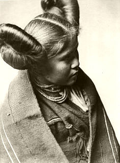
Santa Clara Pueblo is a census-designated place (CDP) in Rio Arriba County, New Mexico, United States and a federally recognized tribe of Native American Pueblo people. Santa Clara Pueblo was established about 1550.

Chicoma Mountain is the highest point in the Jemez Mountains, a prominent mountain range in the U.S. State of New Mexico. The tree line in this area is exceptionally high, and the mountain is forested almost all the way to its summit which is conspicuous from the towns of Los Alamos, Santa Fe, and Española and other areas in the valley of the Rio Grande in northern New Mexico. Like the rest of the Jemez, it is of volcanic origin; it lies on the northeast rim of the Valles Caldera, one of the best examples of a caldera in the United States.

The Rio Chama, a major tributary river of the Rio Grande, is located in the U.S. states of Colorado and New Mexico. The river is about 130 miles (210 km) long altogether. From its source to El Vado Dam its length is about 50 miles (80 km), from El Vado Dam to Abiquiu Dam is about 51 miles (82 km), and from Abiquiu Dam to its confluence with the Rio Grande is about 34 miles (55 km).

The Santa Clara Indian Reservation is an Indian reservation in north-central New Mexico, United States. It is the homeland of a branch of the Pueblo people of Native Americans. The reservation lies on 76.73 sq mi (198.729 km²) of southern Rio Arriba, northeastern Sandoval, and northern Santa Fe Counties. It includes the community of Santa Clara Pueblo, as well as parts of three other communities. The total population living on Santa Clara Pueblo land as of the 2000 census was 10,658 persons. Most of the population lives in the northeastern corner of the reservation. The largest community on reservation land is the city of Española, although a part of the city is not on reservation territory.
La Toma was a legal declaration made by Don Juan de Oñate on 30 April 1598 in present-day San Elizario, Texas. It stated that Spain was taking possession of all territory north of the Rio Grande for King Philip II of Spain. La Toma was the requerimiento legally justifying Oñate's subsequent conquest of the Pueblo villages as the province of Santa Fe de Nuevo Mexico.

The Albuquerque–Santa Fe–Las Vegas combined statistical area is made up of nine counties in north central New Mexico. The combined statistical area consists of the Albuquerque and Santa Fe metropolitan statistical areas, and the Las Vegas, Los Alamos, Española, and Grants micropolitan statistical areas. As of the 2010 census, the CSA had a population of 1,146,049. Roughly 55% of New Mexico's residents live in this area. Prior to the 2013 redefintions, the CSA consisted only of the Santa Fe metropolitan statistical area and the Española micropolitan statistical area. The total land area of the Albuquerque–Santa Fe–Las Vegas combined statistical area is 26,421 sq. mi.

Embudo is an unincorporated community in Rio Arriba County, New Mexico, United States. It is on NM State Road 68. The Embudo Station is located 2.9 miles south of the intersection of NM State Road 75, near where the Embudo River flows into the Rio Grande.
The following is an alphabetical list of articles related to the U.S. state of New Mexico.

The Rio Grande Trail is a proposed long distance trail along the Rio Grande in the U.S. state of New Mexico. The river extends over 1,800 total miles, some 700 miles (1,100 km) of which pass through the heart of New Mexico. It is the state's primary drainage feature and most valuable natural and cultural resource. The river and its bosque provide a wide variety of recreation, including hunting and fishing, birdwatching, river rafting, hiking, biking, and horseback riding. The river also flows through or beside numerous spectacular and geologically interesting landforms, the result of extensive volcanism and erosion within the Rio Grande Rift. Although some trail advocates would like to see the trail extended the full distance through New Mexico, from the Colorado border to the United States–Mexico border, the portion proposed for initial development extends 300 miles (480 km), from Bernalillo south to Las Cruces.

San Gabriel de Yungue-Ouinge, or San Gabriel de Yunque, was the site of the first Spanish capital of its provincial territory of Santa Fe de Nuevo México. It is located where the Rio Chama meets the Rio Grande, west of present-day Ohkay Owingeh, New Mexico. The pueblo of Yuque Yunque was provided as a gesture of goodwill toward Juan de Oñate, and he founded his colonial government there. It was moved to Santa Fe in 1610. The site was declared a National Historic Landmark in 1964. The archaeological site was leveled and plowed over in 1984, and a historical marker has been placed on the west side of the Rio Grande, off the old New Mexico State Road 74.

The Jemez River is a tributary of the Rio Grande in the U.S. state of New Mexico. The river is formed by the confluence of the East Fork Jemez River and San Antonio Creek, which drain a number of tributaries in the area of the Jemez Mountains and Santa Fe National Forest. The Jemez River is about 50 miles (80 km) long, or about 80 miles (130 km) long if its longest headwater tributary, San Antonio Creek, is included. The East Fork Jemez River is about 22 miles (35 km) long. Both San Antonio Creek and the East Fork Jemez River flow through intricate meanders along their courses. The East Fork Jemez is a National Wild and Scenic River.
Velarde is a census-designated place (CDP) in Rio Arriba County, New Mexico, United States. The population was 502 at the time of the 2010 census. Velarde is located on New Mexico State Road 68, in the Rio Grande Rift, right at the point where the road enters the Rio Grande Gorge.

The Rio Brazos is a 42-mile (68 km) long river flowing through northern New Mexico in the United States. It rises in the Tusas Mountains, a subrange of the San Juan Mountains, and runs generally southwest to a confluence with the Rio Chama, part of the larger Rio Grande system.

The North Central Regional Transit District operates a network of several local and intercity bus routes in northern New Mexico, serving Santa Fe, Española, Taos, and many smaller communities along a network of 25 fixed routes and one demand-response route, one dial-a-ride and complementary Paratransit service in the Taos area. Routes operate Monday through Friday only, with the exceptions of the "Taos Express," which operates only on weekends, the Mountain Trail route to the Santa Fe National Forest and Ski Santa Fe, which operates daily, and seasonal daily service from the Town of Taos to Taos Ski Valley. All routes are fare-free, with the exception of the Taos Express and Mountain Trail route which are premium fare-based routes. The service is supported primarily by transit gross receipt taxes, which provides approximately 70% of the RTD's revenues.