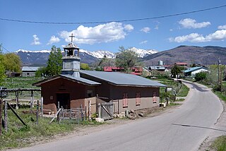
Truchas is a census-designated place in Rio Arriba County, New Mexico, United States. Located along the scenic High Road to Taos, it is halfway between Santa Fe in the south, and Taos to the north.
Hachita is a census-designated place in Grant County, New Mexico, United States. Its population was 49 as of the 2010 census. Hachita has a post office with ZIP code 88040. New Mexico State Road 9, New Mexico State Road 81, and New Mexico State Road 146 pass through the community. Hachita should not be confused with Old Hachita, which is a ghost town several miles west of town.
Hanover is a census-designated place in Grant County, New Mexico, United States. Its population was 167 as of the 2010 census. Hanover has a post office with ZIP code 88041. New Mexico State Road 152 and New Mexico State Road 356 pass through the community. The town was named after the local Hanover Mines. Sofio Henkel, one of the original settlers, came from Hanover, Germany, in 1841 and mined until 1843, when he was driven away by Apaches.
Mimbres is a census-designated place in Grant County, New Mexico, United States. Its population was 667 as of the 2010 census. Mimbres has a post office with ZIP code 88049. New Mexico State Road 35 passes through the community. The post office was established in 1886. It was named after the Mimbres River.

Sacramento is a census-designated place in Otero County, New Mexico, United States. Its population was 58 as of the 2010 census. Sacramento has a post office with ZIP code 88347. New Mexico State Road 521 passes through the community.

San Fidel is a census-designated place in Cibola County, New Mexico, United States. Its population was 138 as of the 2010 census. San Fidel has a post office with ZIP code 87049, which opened on December 24, 1910. New Mexico State Road 124, the original Route 66, also known as the "Old Road," passes through the community.
Coyote is a village in Rio Arriba County, New Mexico, United States. Its population was 128 as of the 2010 census. Coyote has a post office with ZIP code 87012, a store, a gas station and a school. New Mexico State Road 96 passes through the community. Coyote was settled in 1862. The village is part of a larger census-designated place which is named after it.
McIntosh is a census-designated place in Torrance County, New Mexico, United States. Its population was 1,484 as of the 2010 census. McIntosh has a post office with ZIP code 87032, which opened on August 28, 1906. New Mexico State Road 41 passes through the community.

Tome is an unincorporated village and census-designated place in Valencia County, New Mexico, United States. It is located in the Rio Grande valley near the foot of Tome Hill, a notable Catholic pilgrimage site. The village lies along New Mexico State Road 47 and is neighbored by Valencia to the north and Adelino to the south. It is the location of the Valencia Campus of the University of New Mexico. Tome has a post office with ZIP code 87060. The population was 1,867 as of the 2010 census.
Youngsville is a census-designated place in Rio Arriba County, New Mexico, United States. Its population was 56 as of the 2010 census. Youngsville has a post office with ZIP code 87064. New Mexico State Road 96 passes through the community.
Gallina is a census-designated place in Rio Arriba County, New Mexico, United States. Its population was 286 as of the 2010 census. Gallina has a post office with ZIP code 87017. New Mexico State Road 96 passes through the community.
Canjilon is a census-designated place in Rio Arriba County, New Mexico, United States. Its population was 256 as of the 2010 census. Canjilon has a post office with ZIP code 87515. The community is located along New Mexico State Road 115. Canjilon was first settled in 1870, and by 1880, 35 families lived here.
La Plata is a census-designated place in San Juan County, New Mexico, United States. Its population was 612 as of the 2010 census. La Plata has a post office with ZIP code 87418. The community is located at the junction of state roads 170 and 574.
Malaga is a census-designated place and unincorporated community in Eddy County, New Mexico, United States. Its population was 147 as of the 2010 census. Malaga has a post office with ZIP code 88263. U.S. Route 285 passes through the community. Formerly known as Kirkwell, Malaga was founded in the 1890s by Swiss immigrants and was named after the Spanish city of Málaga. Italian laborers were recruited to farm the area, and many settled in Malaga.
Nogal is a census-designated place and unincorporated community in Lincoln County, New Mexico, United States. Its population was 96 as of the 2010 census. Nogal has a post office with ZIP code 88341, which opened on November 9, 1880.
Cordova is an unincorporated community and census-designated place in Richmond County, North Carolina, United States. Its population was 1,775 as of the 2010 census. Cordova has a post office with ZIP code 28330.

Costilla is a census-designated place in Taos County, New Mexico, United States. Its population was 205 as of the 2010 census. Costilla has a post office with ZIP code 87524. State roads 196 and 522 intersect in the community.
Caballo is a census-designated place in Sierra County, New Mexico, United States. Its population was 112 as of the 2010 census. Caballo has a post office with ZIP code 87931. The community is located along New Mexico State Road 187, north and south of Exit 63 on Interstate 25.
Garfield is a census-designated place in Doña Ana County, New Mexico, United States. Its population was 137 at the time of the 2010 census. Garfield has a post office with ZIP code 87936, which opened on September 19, 1896. The community is located on New Mexico State Road 187 south of Exit 51 of Interstate 25.

Winston is a census-designated place in Sierra County, New Mexico, United States. Its population was 61 as of the 2010 census. Winston has a post office with ZIP code 87943, which opened on August 15, 1881. The community was named for Frank Winston, a pioneer miner. New Mexico State Road 52 passes through the community.


