Arenas Valley is a census-designated place in Grant County, New Mexico, United States. Its population was 1,522 as of the 2010 census. Arenas Valley had a post office from December 20, 1944, to April 20, 1987; it still has its own ZIP code, 88022. It was named because it was in the valley of the Rio de Arenas.
Buckhorn is a census-designated place in Grant County, New Mexico, United States. Its population was 200 as of the 2010 census. Buckhorn has a post office with ZIP code 88025. U.S. Route 180 passes through the community. The post office was established in 1913. Buckhorn was named for the nearby Buckhorn Creek.
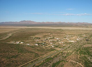
Hachita is a census-designated place in Grant County, New Mexico, United States. Its population was 49 as of the 2010 census. Hachita has a post office with ZIP code 88040. New Mexico State Road 9, New Mexico State Road 81, and New Mexico State Road 146 pass through the community. The ghost town of Old Hachita is several miles west of the town.
Hanover is a census-designated place in Grant County, New Mexico, United States. Its population was 167 as of the 2010 census. Hanover has a post office with ZIP code 88041. New Mexico State Road 152 and New Mexico State Road 356 pass through the community. The town was named after the local Hanover Mines. Sofio Henkel, one of the original settlers, came from Hanover, Germany, in 1841 and mined until 1843, when he was driven away by Apaches.
Mimbres is a census-designated place in Grant County, New Mexico, United States. Its population was 667 as of the 2010 census. Mimbres has a post office with ZIP code 88049. New Mexico State Road 35 passes through the community. The post office was established in 1886. It was named after the Mimbres River.

Cubero is a census-designated place in Cibola County, New Mexico, United States. Its population was 289 as of the 2010 census. Cubero has a post office with ZIP code 87014.

San Fidel is a census-designated place in Cibola County, New Mexico, United States. Its population was 138 as of the 2010 census. San Fidel has a post office with ZIP code 87049, which opened on December 24, 1910. New Mexico State Road 124, the original Route 66, also known as the "Old Road," passes through the community.

La Joya is a census-designated place in Socorro County, New Mexico, United States. The community is located on the east bank of the Rio Grande, 20 miles (32 km) north of Socorro. Its population was 82 as of the 2010 census. La Joya has a post office with ZIP code 87028, which opened on February 28, 1883.
Sandia Park is a census-designated place in Bernalillo County, New Mexico, United States. Its population was 237 as of the 2010 census and 265 as of the 2020 census. Sandia Park has a post office with ZIP code 87047.
McIntosh is a census-designated place in Torrance County, New Mexico, United States. Its population was 1,484 as of the 2010 census. McIntosh has a post office with ZIP code 87032, which opened on August 28, 1906. New Mexico State Road 41 passes through the community.

Gallina is a census-designated place in Rio Arriba County, New Mexico, United States. Its population was 286 as of the 2010 census. Gallina has a post office with ZIP code 87017. New Mexico State Road 96 passes through the community.
Canjilon is a census-designated place in Rio Arriba County, New Mexico, United States. Its population was 256 as of the 2010 census. Canjilon has a post office with ZIP code 87515. The community is located along New Mexico State Road 115. Canjilon was first settled in 1870, and by 1880, 35 families lived here.
Blanco is a census-designated place in San Juan County, New Mexico, United States. Its population was 388 as of the 2010 census. Blanco has a post office with ZIP code 87412, which opened on March 6, 1901. U.S. Route 64 passes through the community.
La Plata is a census-designated place in San Juan County, New Mexico, United States. Its population was 612 as of the 2010 census. La Plata has a post office with ZIP code 87418. The community is located at the junction of state roads 170 and 574.
Navajo Dam is a census-designated place in San Juan County, New Mexico, United States. Its population was 253 as of the 2020 census. Navajo Dam has a post office with ZIP code 87419. The community is located in the vicinity of Navajo Dam.
Nogal is a census-designated place and unincorporated community in Lincoln County, New Mexico, United States. Its population was 96 as of the 2010 census. Nogal has a post office with ZIP code 88341, which opened on November 9, 1880.
La Mesa is a census-designated place and unincorporated community in Doña Ana County, New Mexico, United States. Its population was 728 as of the 2010 census. La Mesa has a post office with ZIP code 88044. NM 28 passes through the community.
Los Ojos is a census-designated place (CDP) in Rio Arriba County, New Mexico, United States. Its population was 125 as of the 2010 census. Los Ojos has a post office with ZIP code 87551, which opened on February 7, 1877. The community is located near U.S. routes 64 and 84.
San Cristobal is a census-designated place in Taos County, New Mexico. Its population was 273 as of the 2010 census, and in the 2020 census the population was 206 persons with a total number of households at 49. San Cristobal has a post office with ZIP code 87564, which opened on February 16, 1932.
Lemitar is a census-designated place in Socorro County, New Mexico, United States. Its population was 330 as of the 2010 census. Lemitar has a post office with ZIP code 87823. Exit 156 on Interstate 25 serves the community.

