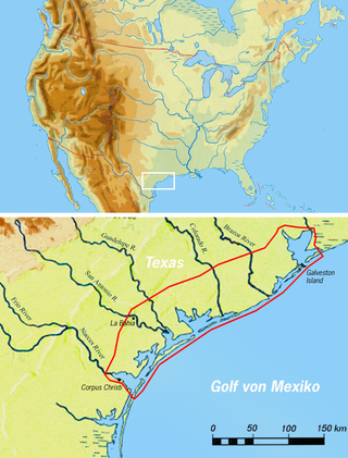
The Karankawa were an Indigenous people concentrated in southern Texas along the coast of the Gulf of Mexico, largely in the lower Colorado River and Brazos River valleys. They consisted of several independent seasonal nomadic groups who shared a language and some culture.
The Adai were a Native American people of northwestern Louisiana and northeastern Texas. They were an Indigenous peoples of the Southeastern Woodlands and part of the Caddo Confederacy.

Los Adaes was the capital of Tejas on the northeastern frontier of New Spain from 1721 to 1773. It included a Franciscan mission, San Miguel de Cuellar de los Adaes, and a presidio, Nuestra Señora del Pilar de Los Adaes. The name Adaes derives from the indigenous Adai people, members of the Caddoan confederacy of Indians who were the people the missionaries aimed to convert to Christianity. The presidio and mission were established to counter French influence in Louisiana territory and defend New Spain from possible invasion or encroachment by the French. In 1763 Louisiana came under the control of Spain and the Los Adaes outpost was no longer necessary for defense. In 1773 the Spanish closed the mission and presidio and forced the population to move to San Antonio.

Spanish Texas was one of the interior provinces of the colonial Viceroyalty of New Spain from 1519 until 1821. Spain claimed ownership of the region in 1519. Slave raids by Spaniards into what became Texas began in the 16th century and created an atmosphere of antagonism with Native Americans (Indians) which would cause endless difficulties for the Spanish in the future. Spain did not attempt to establish a permanent presence until after France established the colony of Fort Saint Louis in 1685. In 1688, the French colony failed due to internal dissention and attacks by the Karankawa Indians. In 1690, responding to fear of French encroachment, Spanish explorer Alonso de León escorted several Catholic missionaries to east Texas, where they established the first mission in Texas. That attempt to establish a Spanish colony failed due to the hostility of the Caddo Indians.

The Spanish Missions in Texas comprise a series of religious outposts established by Spanish Catholic Dominicans, Jesuits, and Franciscans to spread the Catholic doctrine among area Native Americans, but with the added benefit of giving Spain a toehold in the frontier land. The missions introduced European livestock, fruits, vegetables, and industry into the Texas area. In addition to the presidio and pueblo (town), the misión was one of the three major agencies employed by the Spanish crown to extend its borders and consolidate its colonial territories. In all, twenty-six missions were maintained for different lengths of time within the future boundaries of the state of Texas.
The Forts of Texas include a number of historical and operational military installations. For over 200 years, various groups fought over access to or control over the region that is now Texas. Possession of the region was claimed and disputed by the European powers of Spain and France, and the continental countries of Mexico, the United States, the Republic of Texas, and the Confederate States of America. Ownership of specific lands was claimed and disputed by different ethnic groups, including numerous Native American tribes, Mexican residents, Anglo- and African-American settlers, and European immigrants. Access to and control of resources were claimed and disputed by various economic groups, including indigenous hunter/gatherers, farmers, herders, ranchers, colonists, settlers, buffalo hunters, traders, bandits, smugglers, pirates, and revolutionaries. Over the centuries, claims and disputes were enforced by Native American warriors, Spanish conquistadors, French cavaliers, Texas Rangers, local militias, and uniformed regular army regiments of Spain, Mexico, Texas, the United States, and the Confederacy.

Copano Bay is a northwestern extension of Aransas Bay, west of Rockport, Texas in Refugio and Aransas counties. It is supplied with seawater from the Gulf of Mexico via Aransas Bay, and fed freshwater from the Aransas River, Mission River and Copano Creek. As an estuary, the bay is home to a diverse ecosystem consisting of various birds including the endangered whooping crane, and numerous finfish including the redfish as well as shellfish such as oysters. It is classified as a nursery for shrimp, which prohibits production from the bay. Copano Bay is also a historic location for human usage and settlement that dates back to the 18th century, beginning with the historic port of El Copano and the 19th century settlements of St. Mary's of Aransas and Copano. The present-day towns of Bayside, Copano Village and Holiday Beach were all founded in the 20th century. Oil and natural gas are pumped from below the bay's surface, and contribute to the livelihood of the local economies. Recently, areas around the bay were affected by Hurricane Harvey which crossed over the bay as a Category 3 hurricane.

The original Franciscan mission, Nuestra Señora de la Concepción del Socorro, was founded in 1682 by the Franciscan order, to serve displaced Spanish families, American Indians from New Mexico, who fled the central New Mexico region during the Pueblo Revolt. The present Socorro Mission was constructed around 1839 to replace an earlier 18th-century mission destroyed in 1829 by flooding of the Rio Grande. The mission, constructed of adobe surfaced with stucco, is particularly notable for its interior. The finely painted and decorated beams, or vigas, are from the 18th-century mission and were reused when the present church was constructed. The massing, details and use of decorative elements of the Socorro Mission show strong relationships to the building traditions of 17th-century Spanish New Mexico.
José de Azlor y Virto de Vera, second Marquis of San Miguel de Aguayo by marriage, commonly known as the Marqués de Aguayo, was the governor of the provinces of Coahuila and of the New Philippines in New Spain between 1719 and 1722. During his tenure, Aguayo retook eastern Texas from New France without firing a shot. He established or reestablished seven missions and three presidios, and quadrupled the number of Spanish soldiers stationed in Texas. Aguayo and his wife were also owners of a very large estate, or latifundio, in Coahuila. His descendants inherited and expanded the landholdings. The Aguayo dynasty continued until 1825.
Copano is a ghost town on the northwestern shore of Copano Bay in Refugio County, Texas. It is located 5 mi (8.0 km) north of present-day Bayside, on Copano Point. The port, which holds the distinction as the first in South Texas, was founded in the early 18th century by the Spanish, and named for the Copane Indians who resided in the area. Initially, it was used as a port by smugglers and pirates, until 1785, when it was officially opened for use by the Spanish empire. The port was abandoned in the 1880s, following the settlement of the area after the Texas Revolution. Ruins of the town site can still be found, but are currently in danger of falling into Copano Bay.
Aransas City is a ghost town on the tip of the Live Oak Peninsula in Aransas County, Texas near present-day Fulton. It served as a port on Aransas Bay at its confluence with Copano Bay during the 1830s and 1840s, but declined following its loss of a Republic of Texas customhouse to the rival port of Lamar.
James Power was an Irish-born Texan empresario, politician and signer of the Texas Declaration of Independence, known for the land grant he received with partner James Hewetson that included the coastal area between the mouths of the Guadalupe and Nueces Rivers, as well as his founding and service as the first mayor of the Aransas City settlement. He often represented Refugio County during statewide conventions. Was part of the Mexican national era

Mission Nuestra Señora del Espíritu Santo de Zúñiga, also known as Aranama Mission or Mission La Bahía, was a Roman Catholic mission established by Spain in 1722 in the Viceroyalty of New Spain—to convert native Karankawa Indians to Christianity. Together with its nearby military fortress, Presidio La Bahía, the mission upheld Spanish territorial claims in the New World against encroachment from France. The third and final location near Goliad, Texas is maintained now as part of Goliad State Park and Historic Site

The Aranama were an Indigenous people who lived along the San Antonio and Guadalupe rivers of present-day Texas, near the Gulf Coast.
Aranama (Araname), also known as Tamique, is an extinct unclassified language of Texas, USA. It was spoken by the Aranama and Tamique peoples at the Franciscan mission of Espíritu Santo de Zúñiga. It is only known from a two-word phrase from a non-native speaker: himiána tsáyi 'give me water!'. Variations on the name are Taranames, Jaranames ~ Xaranames ~ Charinames, Chaimamé, Hanáma ~ Hanáme.

The Pajalat were a Native American group who lived in the area just south of San Antonio, Texas, prior to the arrival of the Spanish to the region in the 18th century.
James Hewetson was a Texas empresario.

Goliad State Park and Historic Site is a 188.3 acres (76 ha) state park located along the San Antonio River on the southern edge of Goliad, Texas. It was listed on the National Register of Historic Places (#01000258) on March 12, 2001.
Captain Carlos de la Garza (1807–1882), also known as "Don Carlos," was a fourth generation Tejano rancher and entrepreneur in Goliad, Victoria and Refugio counties of Texas. His participation in the Mexican Army leading to the Battle of Coleto was instrumental in the surrender and demise of Colonel James Fannin and the Texian forces.
José Domingo Ramón was a Spanish military man and explorer who founded several missions and a presidio in East Texas to prevent French expansion in the area.


