Pottawatomie County, Oklahoma

Last updated

Pottawatomie County
Pottawatomie county oklahoma courthouse.jpg
Pottawatomie County Courthouse in Shawnee
Map of Oklahoma highlighting Pottawatomie County.svg
Location within the U.S. state of Oklahoma
Oklahoma in United States.svg
Oklahoma's location within the U.S.
Coordinates: 35°12′N96°56′W / 35.2°N 96.94°W / 35.2; -96.94
CountryFlag of the United States.svg United States
StateFlag of Oklahoma.svg  Oklahoma
Founded1891
Named for Potawatomi people
Seat Shawnee
Largest cityShawnee
Area
  Total793 sq mi (2,050 km2)
  Land788 sq mi (2,040 km2)
  Water5.7 sq mi (15 km2)  0.7%%
Population
 (2020)
  Total72,454
  Density91/sq mi (35/km2)
Time zone UTC−6 (Central)
  Summer (DST) UTC−5 (CDT)
Congressional district 5th
Website pottawatomiecountyok.com

Pottawatomie County is a county located in the U.S. state of Oklahoma. As of the 2020 census, the population was 72,454. [1] Its county seat is Shawnee. [2]

Contents

Pottawatomie County is part of the Shawnee, OK micropolitan statistical area, which is included in the Oklahoma City–Shawnee, OK combined statistical area.

History

Pottawatomie County was carved out of land originally given to the Creek and Seminole after their forced removal from Georgia and Florida. After the Civil War, the Creek and Seminole were forced to cede their lands back to the federal government, and the area of Pottawatomie County was used to resettle the Iowa, Sac and Fox, Absentee Shawnee, Potawatomi and Kickapoo tribes. [3]

Non-Indian settlement began on September 22, 1891, when all the tribes except the Kickapoo agreed to land allotment, where communal reservation land was divided and allotted to individual members of the tribes. The remaining land was opened to settlement. [3]

During the land run, Pottawatomie County was organized as County "B" with Tecumseh as the county seat. In 1892, the voters of the county elected to rename County "B" as Pottawatomie County after the Potawatomi Indians.

In 1895, the Kickapoo gave up their land rights and their land was given away to white settlers in the last land run in Oklahoma.

In 1930, Shawnee, now bigger in size than Tecumseh, was approved by the voters to become the new county seat. The Pottawatomie County Court House was built in 1934 by the Public Works Administration. The court house project cost $250,000 to complete. [3]

On May 19, 2013, during an outbreak of tornadoes, a mobile home park was nearly destroyed, killing a 79-year-old man and injuring at least six others as well as damaging at least 35 structures. Frame and brick homes west of Shawnee were also affected. [4]

Geography

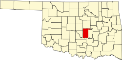
According to the U.S. Census Bureau, the county has a total area of 793 square miles (2,050 km2), of which 788 square miles (2,040 km2) is land and 5.7 square miles (15 km2) (0.7%) is water. [5]

Adjacent counties

Demographics

Historical population
CensusPop.Note
1900 26,412
1910 43,59565.1%
1920 46,0285.6%
1930 66,57244.6%
1940 54,377−18.3%
1950 43,517−20.0%
1960 41,486−4.7%
1970 43,1344.0%
1980 55,23928.1%
1990 58,7606.4%
2000 65,52111.5%
2010 69,4426.0%
2020 72,4544.3%
U.S. Decennial Census [6]
1790-1960 [7] 1900-1990 [8]
1990-2000 [9] 2010-2019 [10] 2020 census [1]
Age pyramid for Pottawatomie County, Oklahoma, based on census 2000 data. USA Pottawatomie County, Oklahoma age pyramid.svg
Age pyramid for Pottawatomie County, Oklahoma, based on census 2000 data.

As of the census of 2010, [11] there were 69,442 people, 25,911 households, and 18,227 families residing in the county. The population density was 34/km2 (88/mi2). There were 29,139 housing units at an average density of 14/km2 (37/mi2). The racial makeup of the county was 76.3% white, 2.9% black or African American, 12.9% Native American, 0.6% Asian, 0.1% Pacific Islander, 0.1% from other races, and 6.3% from two or more races. About 4% of the population were Hispanic or Latino of any race, while 9% were of American, 17% German, 14% Irish and 10% English ancestry. About 90.6% spoke English and 4.2% Spanish as their first language. At the 2020 census, its population grew to 72,454. [1]

As of 2010, there were 25,911 households, out of which 34.5% included children under the age of 18, 51.9% were married couples living together, 13.3% had a female householder with no husband present, 5.1% had a male householder with no wife present, and 29.7% were non-families. About a quarter of households consisted of a single individual and 9.8% had someone living alone who was 65 years of age or older. The average household size was 2.56 and the average family size was 3.04. In the county, the population was spread out, with 25% under the age of 18, 10.2% from 18 to 24, 24.6% from 25 to 44, 25.9% from 45 to 64, and 14.3% who were 65 years of age or older. The median age was 37 years. For every 100 females, there were 92.1 males. For every 100 females age 18 and over, there were 88 males.

As of 2010, the median income for a household in the county was $41,332, and the median income for a family was $50,399. Males had a median income of $39,580 versus $27,495 for females. The per capita income for the county was $20,700. About 14% of families and 18% of the population were below the poverty line, including 26.4% of those under age 18 and 10.3% of those age 65 or over. According to 2021 census estimates, its median household income was $54,896 and the county had a poverty rate of 14.4%. [1]

Government and infrastructure

The Pioneer Library System operates branch libraries in nine cities in Pottawatomie, Cleveland, and McClain counties. [12]

The Oklahoma Department of Corrections operates the Mabel Bassett Correctional Center in an unincorporated area in the county, near McLoud. [13]

Politics

Voter registration and party enrollment as of January 15, 2021 [14]
PartyNumber of VotersPercentage
Republican 21,72452.86%
Democratic 12,47430.35%
Others6,58416.02%
Total41,099100%
United States presidential election results for Pottawatomie County, Oklahoma [15]
Year Republican Democratic Third party
No.%No.%No.%
2020 20,24071.81%7,27525.81%6702.38%
2016 17,84870.12%6,01523.63%1,5896.24%
2012 16,25069.33%7,18830.67%00.00%
2008 17,75369.18%7,91030.82%00.00%
2004 17,21566.59%8,63833.41%00.00%
2000 13,23559.31%8,76339.27%3181.42%
1996 9,80245.06%9,14142.02%2,81012.92%
1992 10,35040.47%8,61633.69%6,60625.83%
1988 12,09957.15%8,87341.92%1970.93%
1984 16,14369.40%6,96629.95%1520.65%
1980 12,46657.05%8,52639.02%8583.93%
1976 9,09044.19%11,25554.71%2261.10%
1972 13,30871.30%4,82225.84%5342.86%
1968 6,89939.44%6,72138.42%3,87322.14%
1964 6,84138.60%10,88461.40%00.00%
1960 9,42153.87%8,06746.13%00.00%
1956 8,49648.85%8,89551.15%00.00%
1952 10,09951.65%9,45548.35%00.00%
1948 4,76031.78%10,22068.22%00.00%
1944 6,48641.42%9,13058.31%430.27%
1940 6,77635.83%12,05863.76%780.41%
1936 4,70327.72%12,18771.82%780.46%
1932 4,06325.27%12,01374.73%00.00%
1928 8,47868.57%3,79730.71%890.72%
1924 4,04038.81%5,07248.73%1,29712.46%
1920 5,35547.56%5,31047.16%5955.28%
1916 2,04231.55%3,27650.61%1,15517.84%
1912 2,10733.75%3,08249.37%1,05416.88%

Transportation

Major highways

Airport

The Shawnee Regional Airport is located 2 nautical miles (3.7 km) northwest from the central business district of Shawnee. It is classified as a general aviation airport.

Communities

Cities

Towns

Census-designated place

Other unincorporated communities

Education

School districts include: [16]

K-12:

Elementary only:

NRHP Sites

The following sites in Pottawatomie County are listed on the National Register of Historic Places:

  • Aldridge Hotel, Shawnee
  • Barnard Elementary School, Tecumseh
  • Beard Cabin, Shawnee
  • Bell Street Historic District, Shawnee
  • Billington Building, Shawnee
  • H. T. Douglas Mansion and Garage, Shawnee
  • Governors Mansion, Shawnee
  • Kerfoot House, Shawnee
  • Nuckolls House, Shawnee
  • Old Santa Fe Railroad Bridge, Wanette

Related Research Articles

<span class="mw-page-title-main">Pontotoc County, Oklahoma</span> County in Oklahoma, United States

Pontotoc County is in the south central part of Oklahoma. As of the 2010 census, the population was 37,492. Its county seat is Ada. The county was created at statehood from part of the Chickasaw Nation in Indian Territory. It was named for a historic Chickasaw tribal area in Mississippi. According to the Encyclopedia of Oklahoma History and Culture, Pontotoc is usually translated "cattail prairie" or "land of hanging grapes."

<span class="mw-page-title-main">Payne County, Oklahoma</span> County in Oklahoma, United States

Payne County is located in the U.S. state of Oklahoma. As of the 2020 census, its population was 81,646. Its county seat is Stillwater. The county was created in 1890 as part of Oklahoma Territory and is named for Capt. David L. Payne, a leader of the "Boomers".

<span class="mw-page-title-main">Oklahoma County, Oklahoma</span> County in Oklahoma, United States

Oklahoma County is located in the central part of the U.S. state of Oklahoma. As of the 2010 census, the population was 718,633, making it the most populous county in Oklahoma. The county seat is Oklahoma City, the state capital and largest city. Oklahoma County is at the heart of the Oklahoma City metropolitan statistical area.

<span class="mw-page-title-main">Muskogee County, Oklahoma</span> County in Oklahoma, United States

Muskogee County is a county located in the U.S. state of Oklahoma. As of the 2020 census, the population was 66,339. The county seat is Muskogee. The county and city were named for the Muscogee (Creek) Nation. The official spelling of the name was changed to Muskogee by the post office in 1900.

<span class="mw-page-title-main">McClain County, Oklahoma</span> County in Oklahoma, United States

McClain County is a county located in south central Oklahoma. As of the 2020 census, the population was 41,662. Its county seat is Purcell. The county was named for Charles M. McClain, an Oklahoma constitutional convention attendee.

<span class="mw-page-title-main">Lincoln County, Oklahoma</span> County in Oklahoma, United States

Lincoln County is a county in eastern Central Oklahoma. As of the 2020 census, the population was 33,458. Its county seat is Chandler.

<span class="mw-page-title-main">Hughes County, Oklahoma</span> County in Oklahoma, United States

Hughes County is a county located in south central U.S. state of Oklahoma. As of the 2020 census, the population was 13,367. Its county seat is Holdenville. The county was named for W. C. Hughes, an Oklahoma City lawyer who was a member of the Oklahoma Constitutional Convention.

<span class="mw-page-title-main">Cleveland County, Oklahoma</span> County in Oklahoma, United States

Cleveland County is a county in the central part of the U.S. state of Oklahoma. The population was 295,528 at the 2020 United States census, making it the third-most populous county in Oklahoma. Its county seat is Norman. The county was named for U.S. President Grover Cleveland.

<span class="mw-page-title-main">Pottawatomie County, Kansas</span> County in Kansas, United States

Pottawatomie County is a county located in the U.S. state of Kansas. As of the 2020 census, the county population was 25,348. The county seat is Westmoreland. The county takes its name from the Potawatomi tribe of Native Americans.

Asher is a town in Pottawatomie County, Oklahoma. The population was 393 at the 2010 census, a decline of 6.2 percent from the figure of 419 in 2000.

<span class="mw-page-title-main">Bethel Acres, Oklahoma</span> Town in Oklahoma, United States

Bethel Acres is a town in Pottawatomie County, Oklahoma. The population was 2,895 at the time of the 2010 census, an increase of 5.9 percent from the figure of 2,735 in 2000. It is primarily a bedroom community for people who work in the three nearby larger cities of Shawnee, Tecumseh and Oklahoma City.

<span class="mw-page-title-main">Earlsboro, Oklahoma</span> Town in Oklahoma, United States

Earlsboro is a town in Pottawatomie County, Oklahoma, United States. The population was 628 at the 2010 census, a decline of 0.8 percent from the figure of 633 in 2000. It was once called "...the town that whisky built and oil broke."

<span class="mw-page-title-main">Macomb, Oklahoma</span> Town in Oklahoma, United States

Macomb is a town in Pottawatomie County, Oklahoma, United States. The population was 32 at the 2010 census, which represented a decline of 47.5 percent from the figure of 61 in 2000.

<span class="mw-page-title-main">McLoud, Oklahoma</span> City in Oklahoma, United States

McLoud is a town in northwestern Pottawatomie County, Oklahoma, United States, and is part of the Oklahoma City Consolidated Metropolitan Area. The population was 4,044 at the 2010 census, a 14.0 percent increase from the figure of 3,548 in 2000. The town was founded in 1895 and named for John W. McLoud, attorney for the Choctaw, Oklahoma and Gulf Railroad.

<span class="mw-page-title-main">Pink, Oklahoma</span> Town in Oklahoma, United States

Pink is a town in Pottawatomie County, Oklahoma, United States, and is part of the Oklahoma City Metropolitan Area. The only town in the United States bearing this name, Pink lies within the boundaries of the Citizen Potawatomi Nation. The 2010 census population was 2,058, a 76.7 percent increase from the figure of 1,165 in 2000.

<span class="mw-page-title-main">Shawnee, Oklahoma</span> City in Oklahoma, United States

Shawnee is a city in and the county seat of Pottawatomie County, Oklahoma, United States. The population was 29,857 in 2010, a 4.9 percent increase from the figure of 28,692 in 2000. The city is part of the Oklahoma City-Shawnee Combined Statistical Area and the principal city of the Shawnee Micropolitan Statistical Area.

<span class="mw-page-title-main">Tecumseh, Oklahoma</span> City in Oklahoma, United States

Tecumseh is a city in Pottawatomie County, Oklahoma. The population was 6,457 at the 2010 census, a 5.9 percent increase from the figure of 6,098 in 2000. It was named for the noted Shawnee chief, Tecumseh. It was designated as the county seat at Oklahoma's statehood, but a county-wide election moved the seat to Shawnee in 1930.

<span class="mw-page-title-main">Wanette, Oklahoma</span> Town in Oklahoma, United States

Wanette is a town in Pottawatomie County, Oklahoma, United States. The population was 350 at the 2010 census, a decline of 13 percent from the figure of 402 in 2000. Wanette is part of the Purcell-Lexington retail trade area and is within the Greater Oklahoma City Metropolitan Area.

<span class="mw-page-title-main">Konawa, Oklahoma</span> City in Oklahoma, United States

Konawa is a city in Seminole County, Oklahoma, United States. The population was 1,298 at the 2010 census. Konawa is a Seminole word meaning, "string of beads."

<span class="mw-page-title-main">Oklahoma City metropolitan area</span> Metropolitan area in Oklahoma, United States

The Oklahoma City metropolitan area is an urban region in the Southern United States. It is the largest metropolitan area in the state of Oklahoma and contains the state capital and principal city, Oklahoma City. It is often known as the Oklahoma City Metro, Oklahoma City Metroplex, or Greater Oklahoma City in addition to the nicknames Oklahoma City itself is known for, such as OKC or "the 405".

References

  1. 1 2 3 4 2020 Population and Housing State Data | Oklahoma
  2. "Find a County". National Association of Counties. Retrieved June 7, 2011.
  3. 1 2 3 Willam H. Mullins, "Pottawatomie County," Encyclopedia of Oklahoma History and Culture, Accessed April 4, 2015.
  4. Lackey, Katharine; Welch, William M. (May 19, 2013). "Tornadoes hit Plains, Midwest; 1 dead in Okla". USA Today. Retrieved May 20, 2013.
  5. "2010 Census Gazetteer Files". United States Census Bureau. August 22, 2012. Retrieved February 22, 2015.
  6. "U.S. Decennial Census". United States Census Bureau. Retrieved February 22, 2015.
  7. "Historical Census Browser". University of Virginia Library. Retrieved February 22, 2015.
  8. Forstall, Richard L., ed. (March 27, 1995). "Population of Counties by Decennial Census: 1900 to 1990". United States Census Bureau. Retrieved February 22, 2015.
  9. "Census 2000 PHC-T-4. Ranking Tables for Counties: 1990 and 2000" (PDF). United States Census Bureau. April 2, 2001. Archived (PDF) from the original on October 9, 2022. Retrieved February 22, 2015.
  10. "State & County QuickFacts". United States Census Bureau. Archived from the original on January 12, 2016. Retrieved November 12, 2013.
  11. "U.S. Census website". United States Census Bureau . Retrieved January 31, 2008.
  12. "Pioneer Library System to buy Borders bookstore building in Norman". NewsOK. The Oklahoman. September 27, 2011. Retrieved October 25, 2011.
  13. "Mabel Bassett Correctional Center Archived December 21, 2010, at the Wayback Machine ." Oklahoma Department of Corrections. Retrieved on November 22, 2010.
  14. "Oklahoma Registration Statistics by County". OK.gov. January 15, 2019. Retrieved January 17, 2021.
  15. Leip, David. "Dave Leip's Atlas of U.S. Presidential Elections". uselectionatlas.org. Retrieved March 30, 2018.
  16. "2020 CENSUS - SCHOOL DISTRICT REFERENCE MAP: Pottawatomie County, OK" (PDF). U.S. Census Bureau. Archived (PDF) from the original on October 9, 2022. Retrieved July 23, 2022. - Text list

Coordinates: 35°12′N96°56′W / 35.20°N 96.94°W / 35.20; -96.94