The name was reported by historian George H. Shirk to have been adopted from a Cherokee settlement in Georgia, and is commonly traced to a Muscogee word meaning “town.”[6][7]
An Etowah post office was established in 1894 and discontinued in 1907 when rural free delivery from Noble reached the area.[8] By 1911, the settlement had about seventy-five residents and supported two general stores, a blacksmith, and a cotton oil mill.[9] A community homecoming began in the 1930s and continued for decades.[10]
Residents petitioned Cleveland County, Oklahoma commissioners in 1967 to incorporate Etowah; the election was never held, but the town operated with a municipal government for years. In 1983, after trustees enacted zoning ordinances, a court ruled Etowah to be an incorporated municipality based on its long, continuous operation.[11]
Etowah remained a dispersed rural community through the twentieth century, with many residents commuting to nearby cities. The population was 122 in 2000, declined to 92 in 2010, and grew to 159 by 2020.[12]
Geography
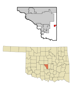
Etowah is located in eastern Cleveland County, Oklahoma, approximately 12 miles (19km) southeast of Norman and 8 miles (13km) east of Noble. The town lies near the intersection of Etowah Road and 192nd Avenue SE in a predominantly rural area characterized by open farmland and scattered woodlands.[13]
According to the United States Census Bureau, Etowah has a total area of 1.99 square miles (5.2km2), all land.[14] The elevation is approximately 1,076 feet (328m) above sea level.[15]
At the 2010 census, there were 92 people, 42 households, and 34 families in the town. The population density was 59.4 inhabitants per square mile (22.9/km2). There were 50 housing units at an average density of 21.4 per square mile (8.3/km2). The racial makeup of the town was 93.44% White, 0.82% Native American, and 5.74% from two or more races. Hispanic or Latino of any race were 3.28% of the population.
Of the 42 households 45.2% had children under the age of 18 living with them, 78.6% were married couples living together, and 19.0% were non-families. 19.0% of households were one person and 4.8% were one person aged 65 or older. The average household size was 2.90 and the average family size was 3.32.
The age distribution was 32.0% under the age of 18, 11.5% from 18 to 24, 32.8% from 25 to 44, 18.0% from 45 to 64, and 5.7% 65 or older. The median age was 31 years. For every 100 females, there were 121.8 males. For every 100 females age 18 and over, there were 102.4 males.
The median household income was $34,375 and the median family income was $34,375. Males had a median income of $26,786 versus $25,833 for females. The per capita income for the town was $10,190. None of the population and none of the families were below the poverty line.
This page is based on this Wikipedia article Text is available under the CC BY-SA 4.0 license; additional terms may apply. Images, videos and audio are available under their respective licenses.