Pocasset, Oklahoma

Last updated

Pocasset, Oklahoma
OKMap-doton-Pocasset.PNG
Location of Pocasset, Oklahoma
Coordinates: 35°10′41″N97°57′33″W / 35.17806°N 97.95917°W / 35.17806; -97.95917
Country United States
State Oklahoma
County Grady
Area
[1]
  Total2.71 sq mi (7.03 km2)
  Land2.71 sq mi (7.03 km2)
  Water0.00 sq mi (0.00 km2)
Elevation
[2]
1,178 ft (359 m)
Population
 (2020)
  Total183
  Density67.45/sq mi (26.04/km2)
Time zone UTC-6 (Central (CST))
  Summer (DST) UTC-5 (CDT)
ZIP code
73079
Area code 405
FIPS code 40-59700 [3]
GNIS feature ID2412493 [2]

Pocasset is a town in Grady County, Oklahoma, United States. The population was 183 at the 2020 census, a 17.3% increase from 2010. [4]

Contents

Geography

Pocasset is located in northwestern Grady County. U.S. Route 81 passes through the town center, leading south 11 miles (18 km) to Chickasha, the county seat, and north 8 miles (13 km) to Minco.

According to the United States Census Bureau, Pocasset has a total area of 0.46 square miles (1.2 km2), all land. [4]

Demographics

Historical population
CensusPop.Note
2000 192
2010 156−18.7%
2020 18317.3%
U.S. Decennial Census [5]

As of the census [3] of 2000, there were 192 people, 75 households, and 54 families living in the town. The population density was 402.5 inhabitants per square mile (155.4/km2). There were 93 housing units at an average density of 195.0 per square mile (75.3/km2). The racial makeup of the town was 91.67% White, 2.60% Native American, 2.60% from other races, and 3.12% from two or more races. Hispanic or Latino of any race were 6.77% of the population.

There were 75 households, out of which 36.0% had children under the age of 18 living with them, 60.0% were married couples living together, 8.0% had a female householder with no husband present, and 28.0% were non-families. 26.7% of all households were made up of individuals, and 5.3% had someone living alone who was 65 years of age or older. The average household size was 2.56 and the average family size was 3.09.

In the town, the population was spread out, with 30.7% under the age of 18, 9.4% from 18 to 24, 29.7% from 25 to 44, 16.7% from 45 to 64, and 13.5% who were 65 years of age or older. The median age was 33 years. For every 100 females, there were 90.1 males. For every 100 females age 18 and over, there were 95.6 males.

The median income for a household in the town was $25,417, and the median income for a family was $30,250. Males had a median income of $26,250 versus $15,000 for females. The per capita income for the town was $10,751. About 11.1% of families and 16.0% of the population were below the poverty line, including 22.4% of those under the age of eighteen and 8.3% of those 65 or over.

Related Research Articles

<span class="mw-page-title-main">Grady County, Oklahoma</span> County in Oklahoma, United States

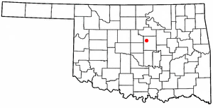
Grady County is a county located in the U.S. state of Oklahoma. As of the 2020 census, the population was 54,795. Its county seat is Chickasha. It was named for Henry W. Grady, an editor of the Atlanta Constitution and southern orator.

<span class="mw-page-title-main">Monument Beach, Massachusetts</span> Census-designated place in Massachusetts, United States

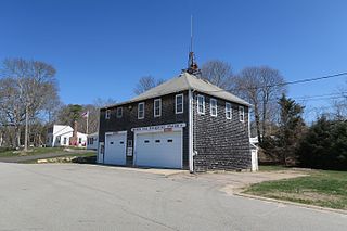
Monument Beach is a census-designated place (CDP) in the town of Bourne in Barnstable County, Massachusetts, United States. The population was 2,790 at the 2010 census.

<span class="mw-page-title-main">Pocasset, Massachusetts</span> Census-designated place in Massachusetts, United States

The village of Pocasset is a census-designated place (CDP) in the town of Bourne in Barnstable County, Massachusetts, United States, located on Buzzards Bay. The population was 2,851 at the 2010 census.

<span class="mw-page-title-main">Knowles, Oklahoma</span> Town in Oklahoma, United States

Knowles is a town in Beaver County, Oklahoma, United States. The population was 6 at the time of the 2020 census.

<span class="mw-page-title-main">Kenefic, Oklahoma</span> Town in Oklahoma, United States

Kenefic is a town in Bryan County, Oklahoma, United States. The population was 196 at the 2010 census, a 2 percent increase from the total of 192 recorded in 2000. The town was named for William Kenefick, president of the Missouri, Oklahoma and Gulf Railroad (MO&G), which had constructed a rail line through the region. The town name has been spelled both Kenefic and Kenefick throughout its history.

<span class="mw-page-title-main">Union City, Oklahoma</span> Town in Oklahoma, United States

Union City is a town in Canadian County, Oklahoma, United States. The population was 1,645 at the 2010 census, a 19.6 percent increase from 1,375 in 2000. It is part of the Oklahoma City metropolitan statistical area.

<span class="mw-page-title-main">Big Cabin, Oklahoma</span> Town in Oklahoma, United States

Big Cabin is a town in Craig County, Oklahoma, United States. The population was 265 at the 2010 census, a decrease of 9.6 percent from the figure of 293 recorded in 2000.

<span class="mw-page-title-main">Alex, Oklahoma</span> Town in Oklahoma, United States

Alex is a town in Grady County, Oklahoma, United States. The population was 482 at the 2020 census.

<span class="mw-page-title-main">Amber, Oklahoma</span> Town in Oklahoma, United States

Amber is a town in Grady County, Oklahoma, United States. The population was 413 at the 2020 census, a 1.4% decrease from 2010.

<span class="mw-page-title-main">Bradley, Oklahoma</span> Town in Oklahoma, United States

Bradley is a town in Grady County, Oklahoma, United States. The population was 78 at the 2020 United States census.

<span class="mw-page-title-main">Ninnekah, Oklahoma</span> Town in Oklahoma, United States

Ninnekah is a town in Grady County, Oklahoma, United States. The population was 775 at the 2020 census, a 22.7% decrease from 2010.

<span class="mw-page-title-main">Norge, Oklahoma</span> Town in Oklahoma, United States

Norge is a town in Grady County, Oklahoma, United States. The population was 129 at the 2020 census, a 11% decrease from 2010.

<span class="mw-page-title-main">Renfrow, Oklahoma</span> Town in Oklahoma, United States

Renfrow is a town in Grant County, Oklahoma, United States. The population was 12 at the 2010 census, a decline of 33.3 percent from the figure of 16 at the 2000 census.

<span class="mw-page-title-main">Carney, Oklahoma</span> Town in Oklahoma, United States

Carney is a town in Lincoln County, Oklahoma, United States. As of the 2020 census, the population of the town was 545.

<span class="mw-page-title-main">Kendrick, Oklahoma</span> Town in Oklahoma, United States

Kendrick is a town in Lincoln County, Oklahoma, United States. The population was 139 at the 2010 census.

<span class="mw-page-title-main">Tryon, Oklahoma</span> Town in Oklahoma, United States

Tryon is a town in Lincoln County, Oklahoma, United States. The population was 491 at the 2010 census. The community is named after early land owner Fred S. Tryon.

<span class="mw-page-title-main">Cole, Oklahoma</span> Town in Oklahoma, United States

Cole is a town in McClain County, Oklahoma, United States. The population was 624 at the 2020 census, up from 555 at the 2010 census.

<span class="mw-page-title-main">Hanna, Oklahoma</span> Town in Oklahoma, United States

Hanna is a town in southwestern McIntosh County, Oklahoma, United States. Its population was 102 at the time of the 2020 Census. It was named for Hanna Bullett, the daughter of a prominent early resident.

<span class="mw-page-title-main">Clearview, Oklahoma</span> Town in Oklahoma, United States

Clearview is a town in Okfuskee County, Oklahoma, United States. The population was 41 at the 2020 Census. It was historically an all-black freedmen's town and was platted by the Lincoln Townsite Company and designated as Lincoln.

<span class="mw-page-title-main">Fitzhugh, Oklahoma</span> Town in Pontotoc County, Oklahoma, United States

Fitzhugh is a town in Pontotoc County, Oklahoma, United States. The population was 204 at the 2000 census.

References

  1. "ArcGIS REST Services Directory". United States Census Bureau. Retrieved September 20, 2022.
  2. 1 2 U.S. Geological Survey Geographic Names Information System: Pocasset, Oklahoma
  3. 1 2 "U.S. Census website". United States Census Bureau . Retrieved January 31, 2008.
  4. 1 2 "Geographic Identifiers: 2010 Demographic Profile Data (G001): Pocasset town, Oklahoma". American Factfinder. U.S. Census Bureau. Retrieved January 26, 2017.[ dead link ]
  5. "Census of Population and Housing". Census.gov. Retrieved June 4, 2015.