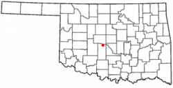
Tuttle, Oklahoma | |
---|---|
Coordinates: 35°18′25″N97°45′23″W / 35.30694°N 97.75639°W | |
Country | United States |
State | Oklahoma |
County | Grady |
Area | |
• Total | 29.49 sq mi (76.37 km2) |
• Land | 29.48 sq mi (76.36 km2) |
• Water | 0.01 sq mi (0.01 km2) |
Elevation | 1,250 ft (380 m) |
Population (2020) | |
• Total | 7,413 |
• Density | 251.45/sq mi (97.09/km2) |
Time zone | UTC-6 (Central (CST)) |
• Summer (DST) | UTC-5 (CDT) |
ZIP code | 73089 |
Area code | 405 |
FIPS code | 40-75450 [3] |
GNIS feature ID | 2412118 [2] |
Website | cityoftuttle.com |
Tuttle is a city in Grady County, Oklahoma, United States. The population was 7,413 with the close of the 2020 census, seeing a 23.2% increase from 6,010 [Data 1] in 2010.
Located east of the Chisholm Trail, Tuttle was developed as a farming and ranching community. The town was platted in 1901 and the land was purchased Chickasaw land from the Colbert Family. The town is named after local rancher James H. Tuttle, a Choctaw by marriage and the father of automobile dealer and politico Holmes Tuttle.
At the time of its founding, Tuttle was located in Pickens County, Chickasaw Nation. [4]
The right-of-way for the St. Louis and San Francisco Railway came from the tribal allotment of Frances Schrock, a Choctaw. Schrock Park is named after her. [5] Tuttle's post office was established in 1902, and the town was incorporated in 1906. [5]
According to the United States Census Bureau, the city has a total area of 29.2 square miles (76 km2), all land.
Tuttle, located in a low-lying river basin along the South Canadian River, is considered to be part of a rapidly growing area of northern McClain and Grady Counties known as the "Tri-City Area" with Newcastle and Blanchard.
Census | Pop. | Note | %± |
---|---|---|---|
1910 | 794 | — | |
1920 | 590 | −25.7% | |
1930 | 766 | 29.8% | |
1940 | 940 | 22.7% | |
1950 | 715 | −23.9% | |
1960 | 855 | 19.6% | |
1970 | 1,640 | 91.8% | |
1980 | 3,051 | 86.0% | |
1990 | 2,807 | −8.0% | |
2000 | 4,294 | 53.0% | |
2010 | 6,019 | 40.2% | |
2020 | 7,413 | 23.2% | |
U.S. Decennial Census |
As of the census of 2010, [3] there were 6,019 people, 2,178 households, and 1,272 families residing in the city. The population density was 206 inhabitants per square mile (80/km2). There were 2,341 housing units at an average density of 56.5 per square mile (21.8/km2). The racial makeup of the city was 88.6% White, 6.1% Native American, 0.4% Asian, 0.09% from other races, and 3.42% from two or more races. Hispanic or Latino of any race were 3.5% of the population. 0.3% of the population is African American.
There were 2,178 households, out of which 33.5% had children under the age of 18 living with them, 67.9% were married couples living together, 9.1% had a female householder with no husband present, and 19.7% were non-families. 16.3% of all households were made up of individuals, and 6.8% had someone living alone who was 65 years of age or older. The average household size was 2.61 and the average family size was 3.02.
In the city, the population was spread out, with 26.7% under the age of 18, 8.5% from 18 to 24, 27.7% from 25 to 44, 26.4% from 45 to 64, and 12.6% who were 65 years of age or older. The median age was 37 years. For every 100 females, there were 97.5 males. For every 100 females age 18 and over, there were 92.4 males.
The median income for a household in the city was $56,126, and the median income for a family was $48,682. Males had a median income of $35,599 versus $25,850 for females. The per capita income for the city was $26,707. About 4.5% of families and 9.8% of the population were below the poverty line, including 6.0% of those under age 18 and 10.2% of those age 65 or over.
Tuttle is a largely agricultural community with a focus on wheat, cotton, corn, alfalfa hay, Bermuda grass hay, and cattle. Nearby Braum's Dairy, the largest farm in the area, is located just outside the city's limits and has a market presence spanning several states. The city serves as a minor bedroom community of Oklahoma City.
The Tuttle Public School system is divided into five buildings: Early Childhood Development (grades Pre-K and K) Tuttle Elementary (grades 1–3), Tuttle Intermediate School (grades 4–5), Tuttle Middle School (grades 6–8), and Tuttle High School (grades 9–12). Their colors are cardinal red and white, and their mascot is the Tiger.
The Tigers have won 82 state championships in their history as recognized by the Oklahoma Secondary Schools Athletic Association.
The following is a list of the sports in which the school won the state championship: [6]
Tuttle has been featured in an Independent Lens series documenting bullying. [7]
Tuttle gained media attention on May 6, 2015 following a tornado that touched down near "Tiger Safari", a local safari park. Nicknamed "Tigernado", it quickly became a popular hashtag on the social media platform Twitter after reports were made that tigers had escaped the facility. The reports were later falsified by the owner after confirming the tiger enclosures were still secure. [8]
Pontotoc County is a county in the south central part of Oklahoma. As of the 2020 census, the population was 38,065. Its county seat is Ada. The county was created at statehood from part of the Chickasaw Nation in Indian Territory. It was named for a historic Chickasaw tribal area in Mississippi. According to the Encyclopedia of Oklahoma History and Culture, Pontotoc is usually translated "cattail prairie" or "land of hanging grapes."
Pittsburg County is a county located in the U.S. state of Oklahoma. As of the 2020 census, the population was 43,773. Its county seat is McAlester. The county was formed from part of the Choctaw Nation in Indian Territory in 1907. County leaders believed that its coal production compared favorably with Pittsburgh, Pennsylvania at the time of statehood.
Murray County is a county located in the southern part of the U.S. state of Oklahoma. As of the 2020 census, the population was 13,904. The county seat is Sulphur. The county was named for William H. Murray, a member and president of the Oklahoma Constitutional Convention and later a Governor of Oklahoma.
McClain County is a county located in south central Oklahoma. As of the 2020 census, the population was 41,662. Its county seat is Purcell. The county was named for Charles M. McClain, an Oklahoma constitutional convention attendee.
Marshall County is a county located on the south-central border of Oklahoma. As of the 2020 census, the population was 15,312. Its county seat is Madill. The county was created at statehood in 1907 from the former Pickens County of the Chickasaw Nation. It was named to honor the maiden name of the mother of George Henshaw, a member of the 1906 Oklahoma Constitutional Convention. The county and its cities are part of the Texoma region.
Love County is a county on the southern border of the U.S. state of Oklahoma. As of the 2020 census, the population was 10,146. Its county seat is Marietta. The county was created at statehood in 1907 and named for Overton Love, a prominent Chickasaw farmer, entrepreneur and politician.
LeFlore County is a county along the eastern border of the U.S state of Oklahoma. As of the 2020 census, the population was 48,129. Its county seat is Poteau. The county is part of the Fort Smith metropolitan area and the name honors a Choctaw family named LeFlore. The United States District Court for the Eastern District of Oklahoma is the federal district court with jurisdiction in LeFlore County.
Johnston County is a county located in the U.S. state of Oklahoma. As of the 2020 census, the population was 10,272. Its county seat is Tishomingo. It was established at statehood on November 16, 1907, and named for Douglas H. Johnston, a governor of the Chickasaw Nation.
Grady County is a county located in the U.S. state of Oklahoma. As of the 2020 census, the population was 54,795. Its county seat is Chickasha. It was named for Henry W. Grady, an editor of the Atlanta Constitution and southern orator.
Bryan County is a county in the U.S. state of Oklahoma. As of the 2020 census, the population was 46,067. Its county seat is Durant. It is the only county in the United States named for Democratic politician William Jennings Bryan.
Achille is a town in Bryan County, Oklahoma, United States. As of the 2010 census, the town population was 492, a 2.8 percent decrease from the figure of 506 recorded in 2000. The town's name is derived from a Cherokee word, atsila, meaning fire.
Kemp is a town in Bryan County, Oklahoma, United States. The population was 133 at the 2010 census, a decrease of 7.8 percent from the total of 144 recorded in 2000.
Ninnekah is a town in Grady County, Oklahoma, United States. The population was 775 at the 2020 census, a 22.7% decrease from 2010.
Milburn is a town in Johnston County, Oklahoma, United States, along the Blue River. The population was 252 as of the 2020 Census. The town is notable as the location of the Chickasaw White House, the former home of Chickasaw Governor Douglas H. Johnston. This home is now a museum and is listed on the NRHP.
Mill Creek is a town in Johnston County, Oklahoma, United States. The population was 293 as of the 2020 Census. Mill Creek Community is an unincorporated area of Johnston County that surrounds the town and claims to have about 1,000 residents, including those who live within the town limits. Local residents consider the town as the focal point of the community.
Talihina is a town in LeFlore County, Oklahoma, United States, its name originating from two Choctaw words, tully and hena, meaning "iron road," a reference to the railroad around which the town was built. It is part of the Fort Smith, Arkansas–Oklahoma Metropolitan Statistical Area. The population was 925 at the time of the 2020 Census.
Newcastle is a city in McClain County, Oklahoma, United States, and part of the Oklahoma City Metropolitan Area. The population was 10,984 at the 2020 census.
Idabel is a city in and the county seat of McCurtain County, Oklahoma, United States. The population was 7,010 at the 2010 census. It is in Oklahoma's southeast corner, a tourist area known as Choctaw Country.
Choctaw is a city in Oklahoma County, Oklahoma, United States, with a population of 12,182 at the 2020 census, a 9.3% increase from 2010. It is the oldest chartered town in Oklahoma Territory. The city is located approximately 10 miles (16.1 km) east of Oklahoma City and is part of the Oklahoma City metropolitan area.
Nicoma Park is a city in Oklahoma County, Oklahoma, United States, and a part of the Oklahoma City metropolitan area. The name Nicoma is a portmanteau of the first three letters of Nichols, for G.A. Nichols, and the last three letters of Oklahoma. The population was 2,313 at the 2020 census, a 3.3% decrease from 2010.