Valley Brook, Oklahoma

Last updated

Valley Brook, Oklahoma
Oklahoma County Oklahoma Incorporated and Unincorporated areas Valley Brook highlighted.svg
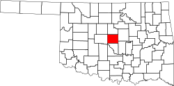
Location in Oklahoma County and the state of Oklahoma.
Coordinates: 35°24′10″N97°28′53″W / 35.40278°N 97.48139°W / 35.40278; -97.48139
Country United States
State Oklahoma
County Oklahoma
Area
[1]
  Total0.26 sq mi (0.68 km2)
  Land0.26 sq mi (0.68 km2)
  Water0.00 sq mi (0.00 km2)
Elevation
[2]
1,266 ft (386 m)
Population
 (2020)
  Total665
  Density2,538.17/sq mi (981.70/km2)
Time zone UTC-6 (Central (CST))
  Summer (DST) UTC-5 (CDT)
FIPS code 40-76500 [3]
GNIS feature ID2413418 [2]

Valley Brook is a town in Oklahoma County, Oklahoma, United States, and is part of the Oklahoma City Metropolitan Area. The population was 765 at the 2010 census.

Contents

History

The origins of Valley Brook were in oil exploration and extraction from the Oklahoma City Field of the 1930s, with the first residence in the town being "oil-camp housing" for workers. [4] On September 14, 2011, Valley Brook Police Chief Melvin Martin Fisher Jr., was arrested for drug trafficking due to his allegedly having possession of methamphetamine and marijuana. [5] He was fired on May 22, 2012. [6] In November 2012, he was found guilty and sentenced to ten years, although the sentence was suspended. [7]

Geography

According to the United States Census Bureau, the town has a total area of 0.3 square miles (0.78 km2), all land.

Demographics

Historical population
CensusPop.Note
1960 1,378
1970 1,197−13.1%
1980 923−22.9%
1990 744−19.4%
2000 1,37584.8%
2010 765−44.4%
2020 665−13.1%
U.S. Decennial Census [8]

As of the census [3] of 2000, there were 817 people, 298 households, and 204 families residing in the town. The population density was 3,037.6 inhabitants per square mile (1,172.8/km2). There were 337 housing units at an average density of 1,253.0 per square mile (483.8/km2). The racial makeup of the town was 77.48% White, 4.41% African American, 7.83% Native American, 0.37% Asian, 1.96% from other races, and 7.96% from two or more races. Hispanic or Latino of any race were 8.20% of the population.

There were 298 households, of which 35.6% had children under the age of 18 living with them, 45.0% were married couples living together, 15.8% had a female householder with no husband present, and 31.5% were non-families. 26.2% of all households were made up of individuals, and 8.7% had someone living alone who was 65 years of age or older. The average household size was 2.74 and the average family size was 3.25.

In the town, the population was spread out, with 30.6% under the age of 18, 10.5% from 18 to 24, 31.1% from 25 to 44, 19.1% from 45 to 64, and 8.7% who were 65 years of age or older. The median age was 30 years. For every 100 females, there were 98.3 males. For every 100 females age 18 and over, there were 98.3 males.

The median income for a household in the town was $21,193, and the median income for a family was $23,565. Males had a median income of $21,071 versus $17,569 for females. The per capita income for the town was $9,316. About 20.3% of families and 25.2% of the population were below the poverty line, including 31.9% of those under age 18 and 19.7% of those age 65 or over.

Education

It is in Oklahoma City Public Schools. [9] Zoned schools are: Bodine Elementary School, [10] Webster Middle School, [11] and Capitol Hill High School. [12]

Revenues

As of 2021 Valley Brook collects a majority of its city revenue from its police force through traffic violations. [13]

Valley Brook City Revenue (FY2013)
CategoryTotal ($)
Court fines/forfeitures$727,684
Sales Tax$101,208
Licenses/permits$39,061
Franchise tax$25,774
Motor vehicle$5,027

Related Research Articles

<span class="mw-page-title-main">Leawood, Kansas</span> City in Kansas, United States

Leawood is a city in Johnson County, Kansas, United States, and is part of the Kansas City metropolitan area. As of the 2020 census, the population of the city was 33,902.

<span class="mw-page-title-main">Capitol Heights, Maryland</span> Town in Maryland

Capitol Heights is a town in Prince George's County, Maryland, United States, located on the border of both the Northeast & Southeast quadrants of Washington. Per the 2020 census, the population was 4,050. The town of Capitol Heights is officially bounded between Southern Avenue NE/SE to the north, Yost Place, and Eastern Avenue NE to the east, the Watts Branch Stream, Brooke Road, and Capitol Heights Boulevard to the south, and Marlboro Pike to the west. The zip code of Capitol Heights is 20743.

Achille is a town in Bryan County, Oklahoma, United States. As of the 2010 census, the town population was 492, a 2.8 percent decrease from the figure of 506 recorded in 2000. The town's name is derived from a Cherokee word, atsila, meaning fire.

<span class="mw-page-title-main">Bridgeport, Oklahoma</span> Town in Oklahoma, United States

Bridgeport is a town in Caddo County, Oklahoma, United States. The population was 116 at the 2010 census.

<span class="mw-page-title-main">Union City, Oklahoma</span> Town in Oklahoma, United States

Union City is a town in Canadian County, Oklahoma, United States. The population was 1,645 at the 2010 census, a 19.6 percent increase from 1,375 in 2000. It is part of the Oklahoma City metropolitan statistical area.

<span class="mw-page-title-main">Elgin, Oklahoma</span> City in Oklahoma, United States

Elgin is a city in northeastern Comanche County, Oklahoma, United States. The population was 2,156 at the 2010 census, a 78 percent increase from 1,210 at the 2000 census. It is included in the Lawton, Oklahoma Metropolitan Statistical Area. It is the site of Fort Sill National Cemetery.

<span class="mw-page-title-main">Wayne, Oklahoma</span> Town in Oklahoma, United States

Wayne is a town in McClain County, Oklahoma, United States. Wayne and McClain County are part of the Oklahoma City Metropolitan Area. The population was 625 at the 2020 census, a 9.2% decrease from 2010. Wayne is part of the "Heart of Oklahoma" exurban area south of Norman and Oklahoma City.

<span class="mw-page-title-main">Choctaw, Oklahoma</span> City in Oklahoma, United States

Choctaw is a city in Oklahoma County, Oklahoma, United States, with a population of 12,182 at the 2020 census, a 9.3% increase from 2010. It is the oldest chartered town in Oklahoma Territory. The city is located approximately 10 miles (16.1 km) east of Oklahoma City and is part of the Oklahoma City metropolitan area.

<span class="mw-page-title-main">Del City, Oklahoma</span> City in Oklahoma, United States

Del City is a city in Oklahoma County, Oklahoma, United States, and a part of the Oklahoma City metropolitan area. The population was 21,822 at the United States Census, 2020, a 2.3% increase from 2010.

<span class="mw-page-title-main">Forest Park, Oklahoma</span> Town in Oklahoma, United States

Forest Park is a town in Oklahoma County, Oklahoma, United States, and a part of the Oklahoma City metropolitan area. The population was 998 at the 2010 census.

<span class="mw-page-title-main">Midwest City, Oklahoma</span> City in Oklahoma, United States

Midwest City is a city in Oklahoma County, Oklahoma, United States, and a part of the Oklahoma City metropolitan area. As of the 2020 census, the population was 58,409, making it the eighth largest city in the state.

<span class="mw-page-title-main">Nichols Hills, Oklahoma</span> City in Oklahoma, United States

Nichols Hills is a city in Oklahoma County, Oklahoma, United States, and a part of the Oklahoma City metropolitan area. The population was 3,870 as of the 2020 census, a 4.3% increase from 2010.

<span class="mw-page-title-main">Nicoma Park, Oklahoma</span> City in Oklahoma, United States

Nicoma Park is a city in Oklahoma County, Oklahoma, United States, and a part of the Oklahoma City metropolitan area. The name Nicoma is a portmanteau of the first three letters of Nichols, for G.A. Nichols, and the last three letters of Oklahoma. The population was 2,313 at the 2020 census, a 3.3% decrease from 2010.

<span class="mw-page-title-main">Spencer, Oklahoma</span> City in Oklahoma, United States

Spencer is a city in Oklahoma County, Oklahoma, United States, and a part of the Oklahoma City metropolitan area. The population was 3,978 at the 2020 census, a 1.7% increase from 2010.

<span class="mw-page-title-main">The Village, Oklahoma</span> City in Oklahoma, United States

The Village is a city in Oklahoma County, Oklahoma, United States, and a part of the Oklahoma City metropolitan area. The population was 9,538 at the 2020 Census.

<span class="mw-page-title-main">Warr Acres, Oklahoma</span> City in Oklahoma, United States

Warr Acres is a city in Oklahoma County, Oklahoma, United States, and a part of the Oklahoma City metropolitan area. It was established after World War II by C.B. Warr, a dynamic businessman, builder, and commercial developer. The population was 10,452 at the 2020 census, a 4.1% increase from 2010.

<span class="mw-page-title-main">Woodlawn Park, Oklahoma</span> Town in Oklahoma, United States

Woodlawn Park is a town in Oklahoma County, Oklahoma, United States, and a part of the Oklahoma City Metropolitan Area. The population was 161 at the 2000 census.

<span class="mw-page-title-main">Brooksville, Oklahoma</span> Town in Oklahoma, United States

Brooksville is a town in Pottawatomie County, Oklahoma, United States. It is one of the thirteen existing all-black towns in Oklahoma. The population was 63 at the 2010 census, a 30 percent decline from the figure of 90 in 2000.

<span class="mw-page-title-main">Ligonier Township, Westmoreland County, Pennsylvania</span> Township in Pennsylvania, United States

Ligonier Township is a township in Westmoreland County, Pennsylvania, United States. Ligonier Township entirely surrounds, but does not include, Ligonier Borough, which is a separate municipality. The township's population was 6,058 at the 2020 census.

Hamilton is a town in Madison County, New York, United States. The population was 6,690 at the 2010 census. The town is named after American Founding Father Alexander Hamilton, and is a college town, with Colgate University dominating the town's employment, culture and population.

References

  1. "ArcGIS REST Services Directory". United States Census Bureau. Retrieved September 20, 2022.
  2. 1 2 U.S. Geological Survey Geographic Names Information System: Valley Brook, Oklahoma
  3. 1 2 "U.S. Census website". United States Census Bureau . Retrieved October 31, 2008.
  4. Everett, Dianna. "Valley Brook". Okhistory. Oklahoma Historical Society. Retrieved January 30, 2024.
  5. Drug dealing charge for Valley Brook police chief
  6. Valley Brook police chief fired drug charges [ dead link ]
  7. Former Valley Brook police chief pleads guilty to drug charge, by Andrew Knittle, News OK, 9 November 2012
  8. "Census of Population and Housing". Census.gov. Retrieved June 4, 2015.
  9. "2020 CENSUS - SCHOOL DISTRICT REFERENCE MAP: Oklahoma County, OK" (PDF). U.S. Census Bureau . Retrieved January 28, 2024. - Detail of Valley Brook from the 2020 Census
  10. "ALL_Elementary%2020190422.pdf" (PDF). Oklahoma City Public Schools . Retrieved January 28, 2024. - Compare with municipal boundaries.
  11. "ALL_Middle%2020190422.pdf" (PDF). Oklahoma City Public Schools . Retrieved January 28, 2024. - Compare with municipal boundaries.
  12. "ALL_High%2020190422.pdf" (PDF). Oklahoma City Public Schools . Retrieved January 28, 2024. - Compare with municipal boundaries.
  13. McIntire, Mike; Keller, Michael (October 31, 2021). "The Demand for Money Behind Many Police Traffic Stops". The New York Times.