Carney, Oklahoma

Last updated

Carney, Oklahoma
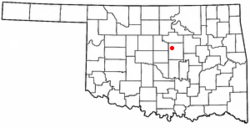
OKMap-doton-Carney.PNG
Location within Oklahoma
Coordinates: 35°48′22″N97°00′56″W / 35.80611°N 97.01556°W / 35.80611; -97.01556 [1]
Country United States
State Oklahoma
County Lincoln
Area
[2]
  Total1.72 sq mi (4.47 km2)
  Land1.71 sq mi (4.42 km2)
  Water0.02 sq mi (0.05 km2)
Elevation
[1]
1,050 ft (320 m)
Population
 (2020)
  Total545
  Density320/sq mi (120/km2)
Time zone UTC−6 (CST)
  Summer (DST) UTC−5 (CDT)
ZIP Code
74832
Area code 405/572
FIPS code 40-12100 [3]
GNIS ID 2413172 [1]

Carney is a town in Lincoln County, Oklahoma, United States. As of the 2020 census, the population of the town was 545.

Contents

History

On May 19, 2013, an EF3 tornado struck the southeastern part of town and nearby rural areas.

Geography

According to the United States Census Bureau, the town has a total area of 1.8 square miles (4.7 km2).

Demographics

Historical population
CensusPop.Note
1910 260
1920 36741.2%
1930 328−10.6%
1940 283−13.7%
1950 277−2.1%
1960 227−18.1%
1970 39674.4%
1980 62257.1%
1990 558−10.3%
2000 64916.3%
2010 647−0.3%
2020 545−15.8%
U.S. Decennial Census

2000 census

As of the census [3] of 2000, there were 649 people, 252 households, and 183 families living in the town. The population density was 367.4 inhabitants per square mile (141.9/km2). There were 281 housing units at an average density of 159.1 per square mile (61.4/km2). The racial makeup of the town was 86.75% White, 1.08% African American, 8.01% Native American, 0.62% from other races, and 3.54% from two or more races. Hispanic or Latino of any race were 1.23% of the population.

There were 252 households, out of which 34.9% had children under the age of 18 living with them, 53.6% were married couples living together, 14.3% had a female householder with no husband present, and 27.0% were non-families. 24.6% of all households were made up of individuals, and 9.1% had someone living alone who was 65 years of age or older. The average household size was 2.58 and the average family size was 3.03.

In the town, the population was spread out, with 31.0% under the age of 18, 6.8% from 18 to 24, 29.0% from 25 to 44, 23.3% from 45 to 64, and 10.0% who were 65 years of age or older. The median age was 35 years. For every 100 females, there were 93.7 males. For every 100 females age 18 and over, there were 88.2 males.

The median income for a household in the town was $27,589, and the median income for a family was $29,688. Males had a median income of $25,972 versus $20,000 for females. The per capita income for the town was $12,020. About 16.1% of families and 19.6% of the population were below the poverty line, including 23.7% of those under age 18 and 11.9% of those age 65 or over.
Education

The community is served by Carney Public Schools #105 school district.

Related Research Articles

<span class="mw-page-title-main">St. Leon, Indiana</span> Town in Indiana, United States

St. Leon or Saint Leon is a town in Kelso Township, Dearborn County, Indiana, United States. The population was 678 at the 2010 census.

<span class="mw-page-title-main">Holland, Indiana</span> Town in Indiana, United States

Holland is a town in Cass Township, Dubois County, in the U.S. state of Indiana. The population was 626 at the 2010 census. It is part of the Jasper Micropolitan Statistical Area.

<span class="mw-page-title-main">Carney, Michigan</span> Village in Michigan, United States

Carney is a village in Menominee County of the U.S. state of Michigan. The population was 179 as of the 2020 census. The village is within Nadeau Township.

<span class="mw-page-title-main">Canton, Oklahoma</span> Town in Oklahoma, United States

Canton is a town in Blaine County, Oklahoma, United States. The population was 625 at the 2010 census.

<span class="mw-page-title-main">Etowah, Oklahoma</span> Town in Oklahoma, United States

Etowah is a town in Cleveland County, Oklahoma, United States. The population was 159 at the 2020 census, a 72.8% increase from 2010.

Custer City is a town in Custer County, Oklahoma, United States. Custer City is northeast of Clinton and northwest of Weatherford along Oklahoma 33. The population was 367 at the time of the 2020 census.

<span class="mw-page-title-main">Hunter, Oklahoma</span> Town in Oklahoma, United States

Hunter is a town in Garfield County, Oklahoma, United States. The population was 165 at the 2010 census, a 4.6 percent decline from the figure of 173 in 2000.

<span class="mw-page-title-main">Ninnekah, Oklahoma</span> Town in Oklahoma, United States

Ninnekah is a town in Grady County, Oklahoma, United States. The population was 775 at the 2020 census, a 22.7% decrease from 2010.

<span class="mw-page-title-main">Norge, Oklahoma</span> Town in Oklahoma, United States

Norge is a town in Grady County, Oklahoma, United States. The population was 129 at the 2020 census, a 11% decrease from 2010.

<span class="mw-page-title-main">Milburn, Oklahoma</span> Town in Oklahoma, United States

Milburn is a town in Johnston County, Oklahoma, United States, along the Blue River. The population was 317 at the 2010 census, an increase of 1.6 percent from the figure of 312 in 2000. The town is notable as the location of the Chickasaw White House, the former home of Chickasaw Governor Douglas H. Johnston. This home is now a museum and is listed on the NRHP.

<span class="mw-page-title-main">Davenport, Oklahoma</span> Town in Oklahoma, United States

Davenport is a town in Lincoln County, Oklahoma, United States. The population was 814 at the 2010 census.

<span class="mw-page-title-main">Ringwood, Oklahoma</span> Town in Oklahoma, United States

Ringwood is a town in Major County, Oklahoma, United States. The population was 401 at the time of the 2020 Census. The town was given its name because it was ringed by woods from northwest to southeast; however, the town is no longer accurate to its name.

<span class="mw-page-title-main">Rosedale, Oklahoma</span> Town in Oklahoma, United States

Rosedale is a town in McClain County, Oklahoma, United States. The population was 62 at the 2020 census, a 8.8% decrease from 2010.

<span class="mw-page-title-main">Lake Aluma, Oklahoma</span> Town in Oklahoma, United States

Lake Aluma is a town in Oklahoma County, Oklahoma, United States, and a part of the Oklahoma City Metropolitan Area. The population was 88 at the 2010 census.

<span class="mw-page-title-main">Tribbey, Oklahoma</span> Town in Oklahoma, United States

Tribbey is a town in Pottawatomie County, Oklahoma, United States.The community was named for Alpheus M. Tribbey, landowner. The population was 337 by the 2020 United States census.

Limestone is a census-designated place (CDP) in Rogers County, Oklahoma, United States, at an elevation of 705 feet. It is located less than 10 miles west of Claremore, Oklahoma on Oklahoma State Highway 20. The population was 753 as of July 2020.

<span class="mw-page-title-main">Valley Park, Oklahoma</span> Town in Oklahoma, United States

Valley Park is a town in Rogers County, Oklahoma, United States. The population was 77 at the 2010 census, up 221 percent from the figure of 24 recorded in 2000.

<span class="mw-page-title-main">Bray, Oklahoma</span> Town in Oklahoma, United States

Bray is a town in Stephens County, Oklahoma, United States. The population was 1,209 at the 2010 census.

<span class="mw-page-title-main">Fair Oaks, Oklahoma</span> Town in Oklahoma, United States

Fair Oaks is a town in Rogers and Wagoner counties in the U.S. state of Oklahoma. The population was 103 at the 2010 census, a 15.6 percent decline from the figure of 122 recorded in 2000. It is a suburb of Tulsa.

<span class="mw-page-title-main">Carneys Point (CDP), New Jersey</span> Populated place in Salem County, New Jersey, US

Carneys Point is an unincorporated community and census-designated place (CDP) located within Carneys Point Township, in Salem County, in the U.S. state of New Jersey. As of the 2010 United States Census, the CDP's population was 7,382.

References

  1. 1 2 3 U.S. Geological Survey Geographic Names Information System: Carney, Oklahoma
  2. "ArcGIS REST Services Directory". United States Census Bureau. Retrieved September 20, 2022.
  3. 1 2 "U.S. Census website". United States Census Bureau . Retrieved January 31, 2008.