Rosedale, Oklahoma

Last updated
Rosedale, Oklahoma
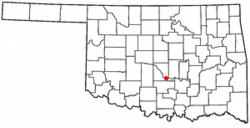
OKMap-doton-Rosedale.PNG
Location of Rosedale, Oklahoma
Coordinates: 34°55′8″N97°11′6″W / 34.91889°N 97.18500°W / 34.91889; -97.18500
Country United States
State Oklahoma
County McClain
Area
[1]
  Total0.08 sq mi (0.20 km2)
  Land0.08 sq mi (0.20 km2)
  Water0.00 sq mi (0.00 km2)
Elevation
1,050 ft (320 m)
Population
 (2020)
  Total62
  Density794.87/sq mi (306.20/km2)
Time zone UTC-6 (Central (CST))
  Summer (DST) UTC-5 (CDT)
FIPS code 40-64000 [2]
GNIS feature ID1097443 [3]

Rosedale is a town in McClain County, Oklahoma, United States. The population was 62 at the 2020 census, a 8.8% decrease from 2010.

Contents

Geography

Rosedale is located at 34°55′08″N97°11′06″W / 34.918793°N 97.184869°W / 34.918793; -97.184869 . [4] According to the United States Census Bureau, the town has a total area of 0.1 square miles (0.26 km2), all land.

Rosedale is located along State Highway 59. [5]

Demographics

Historical population
CensusPop.Note
1940 112
1950 13621.4%
1960 88−35.3%
1970 9811.4%
1980 97−1.0%
1990 48−50.5%
2000 6637.5%
2010 683.0%
2020 62−8.8%
U.S. Decennial Census [6]

At the 2000 census there were 66 people, 26 households, and 19 families living in the town. The population density was 855.3 inhabitants per square mile (330.2/km2). There were 31 housing units at an average density of 401.7 per square mile (155.1/km2). The racial makeup of the town was 86.36% White, 6.06% from other races, and 7.58% from two or more races. Hispanic or Latino of any race were 21.21%. [2]

Of the 26 households 38.5% had children under the age of 18 living with them, 61.5% were married couples living together, 11.5% had a female householder with no husband present, and 26.9% were non-families. 26.9% of households were one person and 15.4% were one person aged 65 or older. The average household size was 2.54 and the average family size was 3.11.

The age distribution was 31.8% under the age of 18, 6.1% from 18 to 24, 30.3% from 25 to 44, 13.6% from 45 to 64, and 18.2% 65 or older. The median age was 29 years. For every 100 females, there were 106.3 males. For every 100 females age 18 and over, there were 114.3 males.

The median household income was $11,875 and the median family income was $15,938. Males had a median income of $0 versus $16,750 for females. The per capita income for the town was $7,285. There were 53.3% of families and 53.3% of the population living below the poverty line, including 77.3% of under eighteens and none of those over 64.

Notable people

Related Research Articles

<span class="mw-page-title-main">Rosedale, California</span> Census-designated place in California, United States

Rosedale is a census-designated place (CDP) in Kern County, California, United States. The population was 14,058 at the 2010 census, up from 8,445 at the 2000 census. Formerly a country town 10 miles (16 km) west of Bakersfield, it is now surrounded by suburban housing and currently has the highest household income in Kern County, according to Census estimates.

<span class="mw-page-title-main">Rosedale, Indiana</span> Town in Indiana, United States

Rosedale is a town in Florida Township, Parke County, in the U.S. state of Indiana. The population was 725 at the 2010 census.

<span class="mw-page-title-main">Sherman, Maine</span> Town in the state of Maine, United States

Sherman is a town in Aroostook County, Maine, United States. The population was 815 at the 2020 census.

<span class="mw-page-title-main">Wade, Maine</span> Town in the state of Maine, United States

Wade is a town in Aroostook County, Maine, United States. The population was 229 at the 2020 census.

<span class="mw-page-title-main">Westfield, Maine</span> Town in the state of Maine, United States

Westfield is a town in Aroostook County, Maine, United States. The population was 455 at the 2020 census.

<span class="mw-page-title-main">Chesterville, Maine</span> Town in Maine, United States

Chesterville is a town in Franklin County, Maine, United States. The population was 1,328 at the 2020 census.

<span class="mw-page-title-main">Stow, Maine</span> Town in the state of Maine, United States

Stow is a town in Oxford County, Maine, United States. The population was 393 at the 2020 census.

Kenduskeag is a town in Penobscot County, Maine, United States. The population was 1,346 at the 2020 census.

Canaan is a town in Somerset County, Maine, United States. The population was 2,193 at the 2020 census.

<span class="mw-page-title-main">Etowah, Oklahoma</span> Town in Oklahoma, United States

Etowah is a town in Cleveland County, Oklahoma, United States. The population was 159 at the 2020 census, a 72.8% increase from 2010.

<span class="mw-page-title-main">Bradley, Oklahoma</span> Town in Oklahoma, United States

Bradley is a town in Grady County, Oklahoma, United States. The population was 78 at the 2020 United States census.

<span class="mw-page-title-main">Norge, Oklahoma</span> Town in Oklahoma, United States

Norge is a town in Grady County, Oklahoma, United States. The population was 129 at the 2020 census, a 11% decrease from 2010.

<span class="mw-page-title-main">Tribbey, Oklahoma</span> Town in Oklahoma, United States

Tribbey is a town in Pottawatomie County, Oklahoma, United States.The community was named for Alpheus M. Tribbey, landowner. The population was 391 at the 2010 census, a 43.2 percent gain from the figure of 273 in 2000.

<span class="mw-page-title-main">Bray, Oklahoma</span> Town in Oklahoma, United States

Bray is a town in Stephens County, Oklahoma, United States. The population was 1,209 at the 2010 census.

<span class="mw-page-title-main">Spring Brook Township, Lackawanna County, Pennsylvania</span> Place in Pennsylvania, United States

Spring Brook Township is a township in Lackawanna County, Pennsylvania, United States. The population was 2,753 at the 2020 census.

<span class="mw-page-title-main">Florence, South Dakota</span> Town in South Dakota, United States

Florence is a town in northwestern Codington County, South Dakota, United States. It is part of the Watertown, South Dakota Micropolitan Statistical Area. The population was 337 at the 2020 census.

<span class="mw-page-title-main">Dolton, South Dakota</span> Town in South Dakota, United States

Dolton is a town in Turner County, South Dakota, United States. The population was 34 at the 2020 census.

<span class="mw-page-title-main">Pax, West Virginia</span> Town in West Virginia, United States

Pax is a town in Fayette County, West Virginia, United States. The current mayor of Pax is William F. Hughes. The population was 167 at the 2010 census.

<span class="mw-page-title-main">Rhodell, West Virginia</span> Unincorporated community in West Virginia, United States

Rhodell is an unincorporated community in Raleigh County, West Virginia, United States. The population was 173 at the 2010 census.

<span class="mw-page-title-main">Auburn, West Virginia</span> Town in West Virginia, United States

Auburn is a town in Ritchie County, West Virginia, United States. The population was 80 at the 2020 census.

References

  1. "ArcGIS REST Services Directory". United States Census Bureau. Retrieved September 20, 2022.
  2. 1 2 "U.S. Census website". United States Census Bureau . Retrieved 2008-01-31.
  3. "US Board on Geographic Names". United States Geological Survey. 2007-10-25. Retrieved 2008-01-31.
  4. "US Gazetteer files: 2010, 2000, and 1990". United States Census Bureau. 2011-02-12. Retrieved 2011-04-23.
  5. Official State Map (Map) (2008 ed.). Oklahoma Department of Transportation.
  6. "Census of Population and Housing". Census.gov. Retrieved June 4, 2015.
  7. "Albuquerque Journal Obituaries". obits.abqjournal.com. Retrieved 2020-10-12.
  8. Cooney, Michael (2012-11-26). "Sandia Lab celebrates original "Mr. Clean" the clean room inventor". Network World. Retrieved 2020-10-12.