Wayne, Oklahoma

Last updated

Wayne, Oklahoma
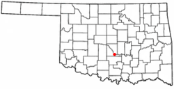
OKMap-doton-Wayne.PNG
Location of Wayne, Oklahoma
Coordinates: 34°55′2″N97°18′58″W / 34.91722°N 97.31611°W / 34.91722; -97.31611
Country United States
State Oklahoma
County McClain
Area
[1]
  Total0.38 sq mi (0.98 km2)
  Land0.38 sq mi (0.98 km2)
  Water0.00 sq mi (0.00 km2)
Elevation
1,102 ft (336 m)
Population
 (2020)
  Total625
  Density1,644.74/sq mi (635.44/km2)
Time zone UTC-6 (Central (CST))
  Summer (DST) UTC-5 (CDT)
ZIP code
73095
Area code 405
FIPS code 40-79300 [2]
GNIS feature ID1099444 [3]

Wayne is a town in McClain County, Oklahoma, United States. Wayne and McClain County are part of the Oklahoma City Metropolitan Area. The population was 625 at the 2020 census, a 9.2% decrease from 2010 (at that time the population was around 688 [4] ). Wayne is part of the "Heart of Oklahoma" exurban area south of Norman and Oklahoma City.

Contents

History

Wayne was named by early railroad workers from Pennsylvania who adopted town names from the railways there, including Wayne, Paoli, Ardmore, and Wynnewood. Wayne is named for Mad Anthony Wayne, a United States Army general and statesman.[ citation needed ] The town was significantly damaged by an EF2 tornado on December 13, 2022. [5]

Geography

According to the United States Census Bureau, the town has a total area of 0.4 square miles (1.0 km2), all land.

Wayne is located at the intersection of U.S. Highway 77 and State Highway 59.

Demographics

Historical population
CensusPop.Note
1910 332
1920 42929.2%
1930 427−0.5%
1940 401−6.1%
1950 50124.9%
1960 5173.2%
1970 61819.5%
1980 6210.5%
1990 519−16.4%
2000 71437.6%
2010 688−3.6%
2020 625−9.2%
U.S. Decennial Census [6]

As of the census [2] of 2000, there were 714 people, 262 households, and 182 families residing in the town. The population density was 1,990.9 inhabitants per square mile (768.7/km2). There were 292 housing units at an average density of 814.2 per square mile (314.4/km2). The racial makeup of the town was 85.29% White, 7.84% Native American, 0.14% Pacific Islander, 2.52% from other races, and 4.20% from two or more races. Hispanic or Latino of any race were 8.68% of the population.

There were 262 households, out of which 38.5% had children under the age of 18 living with them, 49.6% were married couples living together, 16.0% had a female householder with no husband present, and 30.2% were non-families. 25.2% of all households were made up of individuals, and 12.2% had someone living alone who was 65 years of age or older. The average household size was 2.73 and the average family size was 3.28.

In the town, the population was spread out, with 28.3% under the age of 18, 12.3% from 18 to 24, 26.6% from 25 to 44, 18.9% from 45 to 64, and 13.9% who were 65 years of age or older. The median age was 35 years. For every 100 females, there were 95.1 males. For every 100 females age 18 and over, there were 91.8 males.

The median income for a household in the town was $24,554, and the median income for a family was $27,404. Males had a median income of $26,667 versus $14,500 for females. The per capita income for the town was $10,485. About 18.1% of families and 24.7% of the population were below the poverty line, including 35.4% of those under age 18 and 16.4% of those age 65 or over.

Government

The Town of Wayne Court is located in Wayne, and the Wayne Municipal Court is held monthly at the Multi-Purpose Center. The Municipal Judge is appointed by the City Council.

Education

Schools in Wayne include Wayne High School, Wayne Middle School, and Wayne Elementary School. The town also has Mid-America Technology Center, a Vocational School and College.

Notable people

Related Research Articles

<span class="mw-page-title-main">McClain County, Oklahoma</span> County in Oklahoma, United States

McClain County is a county located in south central Oklahoma. As of the 2020 census, the population was 41,662. Its county seat is Purcell. The county was named for Charles M. McClain, an Oklahoma constitutional convention attendee.

<span class="mw-page-title-main">Bokchito, Oklahoma</span> Town in Oklahoma, United States

Bokchito is a town in Bryan County, Oklahoma, United States. The population was 632 at the 2010 census, an increase of 12.1 percent over the figure of 564 recorded in 2000. In the Choctaw language, "bok" means river, and "chito" means big or large, literally translating into "big creek".

<span class="mw-page-title-main">Lexington, Oklahoma</span> City in Oklahoma, United States

Lexington is a city in Cleveland County, Oklahoma, United States. The city population was 2,010 at the 2020 census, a 6.6% decrease from 2010.

<span class="mw-page-title-main">Depew, Oklahoma</span> Town in Oklahoma, United States

Depew is a town in Creek County, Oklahoma, United States. It is 41 miles southwest of Tulsa. The population was 476 at the 2010 census, a decline of 15.6 percent from the figure of 564 recorded in 2000. The town was named in honor of New York Senator Chauncey Depew.

<span class="mw-page-title-main">Maysville, Oklahoma</span> Town in Oklahoma, United States

Maysville is a town in Garvin and McClain counties, Oklahoma, United States. The population was 1,232 at the 2010 census, down from 1,313 in 2000.

<span class="mw-page-title-main">Amber, Oklahoma</span> Town in Oklahoma, United States

Amber is a town in Grady County, Oklahoma, United States. The population was 413 at the 2020 census, a 1.4% decrease from 2010.

<span class="mw-page-title-main">Ninnekah, Oklahoma</span> Town in Oklahoma, United States

Ninnekah is a town in Grady County, Oklahoma, United States. The population was 775 at the 2020 census, a 22.7% decrease from 2010.

<span class="mw-page-title-main">Nash, Oklahoma</span> Town in Oklahoma, United States

Nash is a town in Grant County, Oklahoma, United States. The population was 204 at the 2010 census, an 8.9 percent decline from the figure of 224 in 2000. Nash once shared a school district with the town of Jet, several miles away along U.S. Route 64, but the school folded in 2013 and high school students now attend schools which comprise part of the Timberlake Regional School District, based in Helena. The elementary school is still located in Jet.

<span class="mw-page-title-main">Byars, Oklahoma</span> Town in Oklahoma, United States

Byars is a town in McClain County, Oklahoma, United States. The population was 184 at the 2020 census, down from 255 at the 2010 census.

<span class="mw-page-title-main">Cole, Oklahoma</span> Town in Oklahoma, United States

Cole is a town in McClain County, Oklahoma, United States. The population was 624 at the 2020 census, up from 555 at the 2010 census.

<span class="mw-page-title-main">Dibble, Oklahoma</span> Town in Oklahoma, United States

Dibble is a town in McClain County, Oklahoma, United States. The population within city limits was 867 at the 2020 census, down from 878 at the 2010 census. The community has 8,868 residents in its 73031 zipcode, according to Sperling's Best Places. Dibble is in the outer suburban area west of Purcell and southwest of Norman, in the Oklahoma City Metropolitan Area, according to the U.S. Census.

<span class="mw-page-title-main">Goldsby, Oklahoma</span> Town in Oklahoma, United States

Goldsby is a town in McClain County, Oklahoma, United States. It lies within the Washington public school district and is home to the second largest casino in Oklahoma. As of the 2020 Census, the estimated population was 2,694, a 66 percent increase since 2010.

<span class="mw-page-title-main">Rosedale, Oklahoma</span> Town in Oklahoma, United States

Rosedale is a town in McClain County, Oklahoma, United States. The population was 62 at the 2020 census, a 8.8% decrease from 2010.

<span class="mw-page-title-main">Washington, Oklahoma</span> Town in Oklahoma, United States

Washington is a town in McClain County, Oklahoma, United States. The population was 673 as of the 2020 census, a 0.2% increase from 2010.

<span class="mw-page-title-main">Wanette, Oklahoma</span> Town in Oklahoma, United States

Wanette is a town in Pottawatomie County, Oklahoma, United States. The population was 350 at the 2010 census, a decline of 13 percent from the figure of 402 in 2000. Wanette is part of the Purcell-Lexington retail trade area and is within the Greater Oklahoma City Metropolitan Area.

<span class="mw-page-title-main">Porter, Oklahoma</span> Town in Oklahoma, United States

Porter is a town in Wagoner County, Oklahoma, United States. It promotes itself as "The Peach Capital of Oklahoma." The population was 566 at the 2010 census, a loss of 1.4 percent, compared to 574 at the 2000 census.

<span class="mw-page-title-main">Colony, Oklahoma</span> Town in Oklahoma, United States

Colony is a town in northeastern Washita County, Oklahoma, United States. The population was 136 at the 2010 U.S. census, a decrease of 7.5 percent from 147 in 2000. It was named for the Seger Colony, founded in 1886, which taught modern agricultural techniques to the Arapaho and Cheyenne tribes that would be resettled in the vicinity. Colony is 16 miles (26 km) east and 4 miles (6.4 km) north of Cordell.

<span class="mw-page-title-main">New Cordell, Oklahoma</span> City in Oklahoma, United States

New Cordell is a city in, and county seat of, Washita County, Oklahoma, United States. It lies along U.S. Route 183. The population was 2,915 at the 2010 census. The community was previously established a few miles from the current site, but was moved about 1900. It was named for a U.S. Postal Service employee in Washington D. C., Wayne W. Cordell. The official name is New Cordell, though it is now commonly called Cordell.

<span class="mw-page-title-main">Sharon, Oklahoma</span> Town in Oklahoma, United States

Sharon is a town in Woodward County, Oklahoma, United States. The population was 133 at the 2020 census.

<span class="mw-page-title-main">Chattanooga, Oklahoma</span> Town in Oklahoma, United States

Chattanooga is a town in Comanche and Tillman counties in the U.S. state of Oklahoma. It is located on Oklahoma State Highway 36 about 23.7 driving miles southwest of Lawton. The population was 461 at the 2010 census. The Comanche County portion of Chattanooga is included in the Lawton, Oklahoma Metropolitan Statistical Area.

References

  1. "ArcGIS REST Services Directory". United States Census Bureau. Retrieved September 20, 2022.
  2. 1 2 "U.S. Census website". United States Census Bureau . Retrieved January 31, 2008.
  3. "US Board on Geographic Names". United States Geological Survey. October 25, 2007. Retrieved January 31, 2008.
  4. "Town History" . Retrieved April 6, 2023.
  5. "ArcGIS Web Application". apps.dat.noaa.gov. Retrieved December 15, 2022.
  6. "Census of Population and Housing". Census.gov. Retrieved June 4, 2015.
  7. "Draft Registration Card" . Selective Service System. October 1940. Retrieved August 6, 2022 via fold3.com.
  8. "Remarks as prepared: Oklahoma Gov. Stitt's inaugural address". The Oklahoman . January 14, 2019.