Romulus, Oklahoma

Last updated

Romulus
USA Oklahoma location map.svg
Red pog.svg
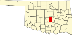
Romulus
Location within the state of Oklahoma
Usa edcp location map.svg
Red pog.svg
Romulus
Romulus (the United States)
Coordinates: 35°06′59″N96°55′24″W / 35.11639°N 96.92333°W / 35.11639; -96.92333
Country United States
State Oklahoma
County Pottawatomie
Time zone UTC-6 (Central (CST))
  Summer (DST) UTC-5 (CDT)

Romulus is an unincorporated community in Pottawatomie County, Oklahoma, United States. It is located east of U.S. Route 177/State Highway 3W. [1]

Related Research Articles

<span class="mw-page-title-main">Oklahoma</span> U.S. state

Oklahoma is a state in the South Central region of the United States, bordered by the state of Texas on the south and west, Kansas on the north, Missouri on the northeast, Arkansas on the east, New Mexico on the west, and Colorado on the northwest. Partially in the western extreme of the Upland South, it is the 20th-most extensive and the 28th-most populous of the 50 United States. Its residents are known as Oklahomans and its capital and largest city is Oklahoma City. The state's name is derived from the Choctaw words okla, 'people' and humma, which translates as 'red'. Oklahoma is also known informally by its nickname, "The Sooner State", in reference to the Sooners, settlers who staked their claims in the Unassigned Lands before the Indian Appropriations Act of 1889 authorized the Land Rush of 1889.

<span class="mw-page-title-main">Oklahoma City</span> Capital city of Oklahoma, United States

Oklahoma City, officially the City of Oklahoma City, and often shortened to OKC, is the capital and largest city of the U.S. state of Oklahoma. The county seat of Oklahoma County, it ranks 20th among United States cities in population, and is the 8th largest city in the Southern United States. The population grew following the 2010 census and reached 681,054 in the 2020 census. The Oklahoma City metropolitan area had a population of 1,396,445, and the Oklahoma City–Shawnee Combined Statistical Area had a population of 1,469,124, making it Oklahoma's largest municipality and metropolitan area by population.

<span class="mw-page-title-main">U.S. Route 66</span> Former US Highway between Chicago and Santa Monica

U.S. Route 66 or U.S. Highway 66 was one of the original highways in the United States Numbered Highway System. It was established on November 11, 1926, with road signs erected the following year. The highway, which became one of the most famous roads in the United States, ran from Chicago, Illinois, through Missouri, Kansas, Oklahoma, Texas, New Mexico, and Arizona before terminating in Santa Monica in Los Angeles County, California, covering a total of 2,448 miles (3,940 km).

<span class="mw-page-title-main">U.S. Route 412</span> Highway in the United States

U.S. Route 412 is an east–west United States highway, first commissioned in 1982. U.S. 412 overlaps expressway-grade Cimarron Turnpike from Tulsa west to Interstate 35 and the Cherokee Turnpike from 5 miles (8.0 km) east of Chouteau, Oklahoma, to 8 miles (13 km) west of the Arkansas state line. It runs the entire length of the Oklahoma Panhandle and traverses the Missouri Bootheel. Despite its numbering it is not associated with U.S. Route 12.

<span class="mw-page-title-main">U.S. Route 56</span>

U.S. Route 56 is an east–west United States highway that runs for approximately 640 miles (1,030 km) in the Midwestern United States. US 56's western terminus is at Interstate 25 Business, US 412 and New Mexico State Road 21 in Springer, New Mexico and the highway's eastern terminus is at US 71 in Kansas City, Missouri. Much of it follows the Santa Fe Trail.

<span class="mw-page-title-main">Oklahoma State Highway 74</span> Highway in Oklahoma

State Highway 74, usually abbreviated as SH-74 or OK-74 is the numbering of two different highways maintained by the U.S. state of Oklahoma. These highways were once a single major north–south route, connecting Oklahoma City to more rural parts of the state. The original road stretched from SH-7 near Tatums to SH-11 west of Deer Creek.

<span class="mw-page-title-main">Oklahoma State Highway 9</span> Highway in Oklahoma

State Highway 9, abbreviated as SH-9, OK-9, or simply Highway 9, is a major east–west highway in the U.S. state of Oklahoma. Spanning across the central part of the state, SH-9 begins at the Texas state line west of Vinson, Oklahoma, and ends at the Arkansas state line near Fort Smith, Arkansas. State Highway 9 is a major highway around the Norman area. At 348.1 miles (560.2 km), SH-9 is Oklahoma's second-longest state highway.

<span class="mw-page-title-main">Oklahoma State Highway 99</span> Highway in Oklahoma

State Highway 99 (SH-99) is a north–south state highway through central Oklahoma. It runs from the Texas state line at Lake Texoma to the Kansas state line near Lake Hulah. It is 241.5 miles (388.7 km) long. The highway overlaps U.S. Highway 377 (US-377) for over half its length.

<span class="mw-page-title-main">Cross Timbers</span> Ecoregion in Texas, Oklahoma, and Kansas

The term Cross Timbers, also known as Ecoregion 29, Central Oklahoma/Texas Plains, is used to describe a strip of land in the United States that runs from southeastern Kansas across Central Oklahoma to Central Texas. Made up of a mix of prairie, savanna, and woodland, it forms part of the boundary between the more heavily forested eastern country and the almost treeless Great Plains, and also marks the western habitat limit of many mammals and insects.

<span class="mw-page-title-main">Oklahoma Department of Transportation</span>

The Oklahoma Department of Transportation (ODOT) is an agency of the government of Oklahoma responsible for the construction and maintenance of the state's transportation infrastructure. Under the leadership of the Oklahoma secretary of transportation and ODOT executive director, the department maintains public infrastructure that includes highways and state-owned railroads and administers programs for county roads, city streets, public transit, passenger rail, waterways and active transportation. Along with the Oklahoma Turnpike Authority, the department is the primary infrastructure construction and maintenance agency of the State.

<span class="mw-page-title-main">U.S. Route 77 in Oklahoma</span> Section of U.S. Highway in Oklahoma, United States

U.S. Highway 77 (US-77) in Oklahoma is a 267.21-mile-long (430.03 km) U.S. Highway in the U.S. state of Oklahoma. It travels from south to north, paralleling Interstate 35 (I-35), connecting Texas to Kansas through the central part of the state. It travels through many major cities, including Ardmore, Oklahoma City and its suburbs, Guthrie, and Ponca City. It has four lettered spur routes.

On a simple east/west basis, Western Oklahoma is popularly considered that part of the state west of I-35. I-35 creates a north/south line through the approximate center of the main body of the state, passing through Oklahoma City, the state capital.

<span class="mw-page-title-main">U.S. Route 62 in Oklahoma</span> Highway in Oklahoma

In Oklahoma, U.S. Highway 62 (US 62) runs diagonally across the state, from the Texas state line in far southwestern Oklahoma to the Arkansas state line near Fayetteville. US-62 spends a total of 402.48 miles (647.73 km) in the Sooner State. The highway passes through fifteen of Oklahoma's counties. Along the way the route serves two of Oklahoma's largest cities, Lawton and Oklahoma City, as well as many regionally important cities, like Altus, Chickasha, Muskogee, and Tahlequah. Despite this, US-62 has no lettered spur routes like many other U.S. routes in Oklahoma do.

<span class="mw-page-title-main">2008 United States presidential election in Oklahoma</span> Election in Oklahoma

The 2008 United States presidential election in Oklahoma took place on November 4, 2008, and was part of the 2008 United States presidential election. Voters chose seven representatives, or electors to the Electoral College, who voted for president and vice president.

<span class="mw-page-title-main">U.S. Route 70 in Oklahoma</span> Highway in Oklahoma

U.S. Route 70 is a transcontinental U.S. highway extending from Globe, Arizona to Atlantic, North Carolina. Along the way, 289.81 miles (466.40 km) of its route passes through the state of Oklahoma. Entering the state south of Davidson, the highway serves Oklahoma's southern tier before exiting the state east of Broken Bow. It serves the cities of Ardmore, Durant, Hugo, and Idabel, as well as Tillman, Cotton, Jefferson, Carter, Marshall, Bryan, Choctaw, and McCurtain counties.

<span class="mw-page-title-main">U.S. Route 412 in Oklahoma</span> Highway in Oklahoma

U.S. Route 412 is a U.S. highway in the south-central portion of the United States, connecting Springer, New Mexico to Columbia, Tennessee. A 504.11-mile (811.29 km) section of the highway crosses the state of Oklahoma, traversing the state from west to east. Entering the state southwest of Boise City, US-412 runs the length of the Oklahoma Panhandle and serves the northern portion of the state's main body, before leaving the state at West Siloam Springs. Along the way, the route serves many notable cities and towns, including Boise City, Guymon, Woodward, Enid, and the state's second-largest city, Tulsa.

<span class="mw-page-title-main">U.S. Route 64 in Oklahoma</span> Highway in Oklahoma

U.S. Route 64 (US-64) is a U.S. highway running from the Four Corners area to the Outer Banks of North Carolina. Between these two points, the highway passes through the entire width of Oklahoma; a total of 591.17 miles (951.40 km) of US-64 lies in the state of Oklahoma. US-64 enters the state from New Mexico, crossing the line between the two states between Clayton, New Mexico, and Boise City in Cimarron County. The route runs the full length of the Oklahoma Panhandle, then serves the northernmost tier of counties in the main body of the state before dipping southeastward to Tulsa, the state's second-largest city. From Tulsa, the highway continues southeast, leaving Oklahoma just west of Fort Smith, Arkansas. In addition to Tulsa, US-64 serves fifteen Oklahoma counties and the cities of Guymon, Woodward, Enid, and Muskogee.

<span class="mw-page-title-main">2016 United States presidential election in Oklahoma</span> Election in Oklahoma

The 2016 United States presidential election in Oklahoma was held on Tuesday, November 8, 2016, as part of the 2016 United States presidential election in which all 50 states plus the District of Columbia participated. Oklahoma voters chose electors to represent them in the Electoral College via a popular vote, pitting the Republican Party's nominee, businessman Donald Trump, and running mate Indiana Governor Mike Pence against Democratic Party nominee, former Secretary of State Hillary Clinton, and her running mate Virginia Senator Tim Kaine. Oklahoma has seven electoral votes in the Electoral College.

<span class="mw-page-title-main">2020 United States presidential election in Oklahoma</span> Election in Oklahoma

The 2020 United States presidential election in Oklahoma was held on Tuesday, November 3, 2020, as part of the 2020 United States presidential election in which all 50 states plus the District of Columbia participated. Oklahoma voters chose electors to represent them in the Electoral College via a popular vote, pitting the Republican Party's nominee, incumbent President Donald Trump, and running mate Vice President Mike Pence against Democratic Party nominee, former Vice President Joe Biden, and his running mate California Senator Kamala Harris. Oklahoma has seven electoral votes in the Electoral College.

References

  1. Official State Map (Map) (2005-2006 ed.). Oklahoma Department of Transportation.