Dale | |
|---|---|
| Motto: "Go Dale" | |
 Dale Location within the state of Oklahoma  Dale Dale (the United States) | |
| Coordinates: 35°23′03″N97°02′36″W / 35.38417°N 97.04333°W | |
| Country | United States |
| State | Oklahoma |
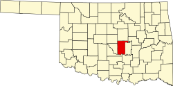
| County | Pottawatomie |
| Government | |
| Area | |
• Total | 0.74 sq mi (1.92 km2) |
| • Land | 0.74 sq mi (1.92 km2) |
| • Water | 0 sq mi (0.00 km2) |
| Elevation | 1,034 ft (315 m) |
| Population (2020) | |
• Total | 175 |
| • Density | 235.9/sq mi (91.08/km2) |
| Time zone | UTC-6 (Central (CST)) |
| • Summer (DST) | UTC-5 (CDT) |
| Area codes | 405/572 |
| FIPS code | 40-19150 |
| GNIS feature ID | 2629915 [2] |
Dale is an unincorporated community and census-designated place located on State Highway 270 in Pottawatomie County, Oklahoma, United States. It lies in the North Canadian River bottom, a few miles northwest of Shawnee. The population was 175 at the time of the 2020 Census, [3] a slight decrease over the 2010 census figure of 186. [4]
Contents
Dale was platted along the Rock Island railroad line before statehood. The Dale Post Office opened October 26, 1893. It was initially named King in honor of John King, an Absentee-Shawnee Indian who owned the allotted land on which the community was founded. The community was renamed in 1895, for Frank Dale, the second Chief Justice of the Territorial Supreme Court (1893-1898).