
USS Virginia (BB-13) was a United States Navy pre-dreadnought battleship, the lead ship of her class. She was the fifth ship to carry her name. Virginia was laid down in May 1902 at the Newport News Shipbuilding and Dry Dock Company in Newport News, Virginia, was launched in April 1904, and was commissioned into the fleet in May 1906. The ship was armed with an offensive battery of four 12-inch (305 mm) guns and eight 8-inch (203 mm) guns, and she was capable of a top speed of 19 knots.

The Virginia Peninsula is a peninsula in southeast Virginia, bounded by the York River, James River, Hampton Roads and Chesapeake Bay. It is sometimes known as the Lower Peninsula to distinguish it from two other peninsulas to the north, the Middle Peninsula and the Northern Neck.

Fort Wool is a decommissioned island fortification located in the mouth of Hampton Roads, adjacent to the Hampton Roads Bridge-Tunnel (HRBT). Officially known as Rip Raps Island, the fort has an elevation of 7 feet and sits near Old Point Comfort, Old Point Comfort Light, Willoughby Beach and Willoughby Spit, approximately one mile south of Fort Monroe.

The Elizabeth River is a 6-mile-long (10 km) tidal estuary forming an arm of Hampton Roads harbor at the southern end of Chesapeake Bay in southeast Virginia in the United States. It is located along the southern side of the mouth of the James River, between the cities of Portsmouth, Norfolk, and Chesapeake. Forming the core of the Hampton Roads harbor, it is heavily supported by its tributaries which depend upon it.

Joint Expeditionary Base–Little Creek (JEB–LC), formerly known as Naval Amphibious Base Little Creek and commonly called simply Little Creek, is the major operating base for the Amphibious Forces in the United States Navy's Atlantic Fleet. The base comprises four locations in three states, including almost 12,000 acres (4,900 ha) of real estate. Its Little Creek location in Virginia Beach, Virginia, totals 2,120 acres (860 ha) of land. Outlying facilities include 350 acres (140 ha) located just north of Training Support Center Hampton Roads in Virginia Beach and 21 acres (8.5 ha) known as Radio Island at Morehead City, North Carolina, used for U.S. Coast Guard ships and personnel as well as serves as an amphibious embarkation/debarkation area for U.S. Marine Corps units at Marine Corps Base Camp Lejeune, North Carolina. It is also home to the Naval School of Music.

Fort Monroe, is a former military installation in Hampton, Virginia, at Old Point Comfort, the southern tip of the Virginia Peninsula, United States. It is currently managed by partnership between the Fort Monroe Authority for the Commonwealth of Virginia, the National Park Service, and the city of Hampton as the Fort Monroe National Monument. Along with Fort Wool, Fort Monroe originally guarded the navigation channel between the Chesapeake Bay and Hampton Roads—the natural roadstead at the confluence of the Elizabeth, the Nansemond and the James rivers.
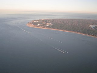
Old Point Comfort is a point of land located in the independent city of Hampton, Virginia. Previously known as Point Comfort, it lies at the extreme tip of the Virginia Peninsula at the mouth of Hampton Roads in the United States. It was renamed Old Point Comfort to differentiate it from New Point Comfort 21 miles (34 km) up the Chesapeake Bay. A group of enslaved Africans was brought to colonial Virginia at this point in 1619. Today the location is home to Continental Park and Fort Monroe National Monument.

The Battle of Craney Island was a victory for the United States during the War of 1812. The battle saved the city of Norfolk, and the adjacent city of Portsmouth, from British invasion. Especially important to Virginia and northeastern North Carolina, the region was a major hub for American commerce.

Craney Island is a point of land in the independent city of Portsmouth in the South Hampton Roads region of eastern Virginia in the United States. The location, formerly in Norfolk County, is near the mouth of the Elizabeth River opposite Lambert's Point on Hampton Roads. It is home to the Craney Island US Naval Supply Center, managed by the U.S. Army Corps of Engineers.
Cape Henry is a cape on the Atlantic shore of Virginia located in the northeast corner of Virginia Beach. It is the southern boundary of the entrance to the long estuary of the Chesapeake Bay.
Joint Expeditionary Base-Fort Story, commonly called simply Fort Story is a sub-installation of Joint Expeditionary Base Little Creek–Fort Story, which is operated by the United States Navy. Located in the independent city of Virginia Beach, Virginia at Cape Henry at the entrance of the Chesapeake Bay, it offers a unique combination of features including dunes, beaches, sand, surf, deep-water anchorage, variable tide conditions, maritime forest and open land. The base is the prime location and training environment for both U.S. Army amphibious operations and Joint Logistics-Over-the-Shore (LOTS) training events.

The history of Virginia Beach, Virginia, goes back to the Native Americans who lived in the area for thousands of years before the English colonists landed at Cape Henry in April 1607 and established their first permanent settlement at Jamestown a few weeks later. The Colonial Virginia period extended until 1776 and the American Revolution, and the area has been part of the Commonwealth of Virginia ever since.

Henry Town, Henry Towne, or Henries Towne was an early English colonial settlement near Cape Henry, the southern point and gateway to the Chesapeake Bay in the Colony and Dominion of Virginia, now in modern Virginia Beach, Virginia, on the East Coast of the United States. Archaeologist Floyd Painter of the Norfolk Museum of Arts and Sciences originally excavated the site in 1955, but it was only conclusively determined to be Henry Town in 2007 by United States Army scientists reviewing the site's artifacts, and no primary source documents exist. It was located east of Norfolk, Virginia and north of Chesapeake and south of the Hampton Roads harbor at approximately 36°54′30″N76°7′20″W. The historical and archeological site is immediately north of U.S. Route 60 on what is now Lake Joyce, formerly an inlet connecting with Pleasure House Creek, a western branch of the Lynnhaven River, itself an estuary of the Chesapeake Bay and Hampton Roads.
Fort Algernon was established in the fall of 1609 at the mouth of Hampton Roads at Point Comfort in the Virginia Colony. A strategic point for guarding the shipping channel leading from the Chesapeake Bay, Fort Monroe was built there beginning in the 1830s. The area is now known as Old Point Comfort. Long part of Elizabeth City County, the site is now located in the independent city of Hampton, Virginia.

The history of Hampton Roads dates to 1607, when Jamestown was founded. Two wars have taken place in addition to many other historical events.

Cape Charles Air Force Station is a closed United States Air Force General Surveillance Radar station. It is located 3.6 miles (5.8 km) south of Townsend, Virginia. It was closed in 1981. From 1941 to 1948 it was Fort John Custis of the United States Army Coast Artillery Corps. Since 1984 the site has been in the Eastern Shore of Virginia National Wildlife Refuge. For this article's purposes the term "Fort John Custis" includes the nearby Fisherman Island.

