The Chesapeake & Delaware Canal is a 14-mile (22.5 km)-long, 450-foot (137.2 m)-wide and 35-foot (10.7 m)-deep ship canal that connects the Delaware River with the Chesapeake Bay in the states of Delaware and Maryland in the United States. The C&D Canal is owned and operated by the U.S. Army Corps of Engineers, Philadelphia District. The project office in Chesapeake City, Maryland, is also the site of the C&D Canal Museum and Bethel Bridge Lighthouse. In Delaware, the canal is itself a significant landmark and cultural boundary, considered a divide between the urbanized northern portion of the state and the rural southern portion, and demarcates an unofficial northern limit to the Delmarva Peninsula.

William Strickland, was a noted architect and civil engineer in Philadelphia, Pennsylvania; and Nashville, Tennessee. A student of Benjamin Latrobe and mentor to Thomas Ustick Walter, Strickland helped establish the Greek Revival movement in the United States. A pioneering engineer, he wrote a seminal book on railroad construction, helped build several early American railroads, and designed the first ocean breakwater in the Western Hemisphere.

Fort Miles was a United States Army installation located on Cape Henlopen near Lewes, Delaware. Although funds to build the fort were approved in 1934, it was 1941 before construction began on the fort. On 3 June 1941 it was named for Major General Nelson A. Miles. As the primary fort of the Harbor Defenses of the Delaware, it was built to defend Delaware Bay and the Delaware River and to protect domestic shipping from enemy fire between Cape May and Cape Henlopen, particularly from the German surface fleet. The fort also operated a controlled underwater minefield to prevent ships entering the Delaware River estuary.

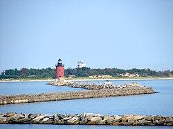
The Harbor of Refuge Light is a lighthouse built on the ocean end of the outer Delaware Breakwater at the mouth of the Delaware Bay, just off Cape Henlopen. It was built to function with the Delaware Breakwater East End Light in order to mark the National Harbor of Refuge.

Rockland Harbor Breakwater Light is a historic lighthouse complex at the end of the Rockland Breakwater in the harbor of Rockland, Maine. Replacing a light station at Jameson Point, the light was established in 1902, about two years after completion of the breakwater. Now automated, it continues to serve as an active aid to navigation. The light was added to the National Register of Historic Places as Rockland Breakwater Lighthouse on March 20, 1981.

The Manistique Breakwater lighthouse is located in the harbor of Manistique, Michigan. It was listed on the National Register of Historic Places in 2005.

The U.S. Army Corps of Engineers Duluth Vessel Yard is a federal port facility in Duluth, Minnesota, United States. It houses the United States Army Corps of Engineers (USACE) resources used to maintain the harbors of the Twin Ports of Duluth and Superior, Wisconsin. It was established on Minnesota Point in 1903, though most of its present configuration dates to a flurry of construction in 1941.

Fort DuPont, named in honor of Rear Admiral Samuel Francis Du Pont, is located between the original Delaware City and the modern Chesapeake and Delaware Canal on the original Reeden Point tract, which was granted to Henry Ward in 1675. Along with two other forts of the Harbor Defenses of the Delaware, it defended the Delaware River and the water approach to Philadelphia from 1900 through 1942. In 2016, the acreage which is not in the state park system was annexed into Delaware City.

The Lorain West Breakwater Light, also called the Lorain Harbor Light, is a lighthouse in Lorain, Ohio. The light was built in 1917 on Lake Erie by the United States Army Corps of Engineers. It was taken out of service in 1965 when it was replaced by an automated lighttower on a nearby breakwater. The light was addedto the National Register of Historic Places in 1978.
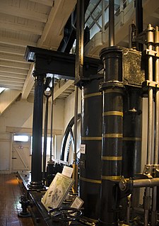
The Old Lock Pump House on the Chesapeake & Delaware Canal was one of the first National Historic Landmarks to recognize an engineering achievement rather than an important building or a place associated with an historic event. The pump house, whose first element was built in 1837, preserves a feature of the old canal, which relied on locks and pumps to move vessels over the low divide of the Delmarva Peninsula between Chesapeake Bay and Delaware Bay. Because there are no large rivers on the peninsula, water had to be pumped uphill to fill the upper canal and locks. When the canal was cut deeper in the twentieth century, such measures were no longer required, and the pump house is one of the last relics of the old canal.

The Ontonagon Harbor Piers Historic District is historic shipping structure located on the Ontonagon River at Lake Superior in Ontonagon, Michigan. It was listed on the National Register of Historic Places in 2001.

The Grand Marais Harbor of Refuge Inner and Outer Lights are a pair of lighthouses located on the west pier at the entry to Grand Marais Harbor of Refuge, in Grand Marais, Michigan. They were listed on the National Register of Historic Places in 2012.

The Tug Ludington is a World War II era tugboat built in 1943 at Jacobson Shipyard in Oyster Bay, New York. The U.S. Army designated the tug LT-4. The tug's armament consisted of two 50 caliber machine guns and participated in the D-Day invasion of Normandy, towing ammunition barges across the English Channel. After World War II, it joined the U.S. Army Transportation Corps until 1947 when the Corps of Engineers transferred the tug to Kewaunee, Wisconsin and then renamed it the Tug Ludington. It was used in the construction and maintenance of many harbors on the Great Lakes and now rests in Harbor Park in Downtown, Kewaunee and is open to visitors for tours. As the Major Wilbur Fr. Browder, the tug is on the National Register of Historic Places listings in Kewaunee County, Wisconsin.

The Navigation Structures at Frankfort Harbor are a collection of breakwaters, piers, and other structures in Lake Michigan located at the foot of Second Street in Frankfort, Michigan. They were listed on the National Register of Historic Places in 1997.

The Rockland Breakwater is a breakwater sheltering the harbor of Rockland, Maine. More than 4,000 feet (1,200 m) long, it was built in the 1890s by the United States Army Corps of Engineers out of locally quarried granite to improve the harbor's ability to shelter ships from coastal storms. It was listed on the National Register of Historic Places in 2003.

The Manistee Harbor, South Breakwater is a navigational structure located at the mouth of the Manistee River, in Manistee, Michigan. It was listed on the National Register of Historic Places in 1995. The breakwater is significant due to its construction, which represents a final stage in the United States Army Corps of Engineers's use of timber crib substructures in pier and breakwater construction.

The Navigation Structures at Harbor Beach Harbor are a series of breakwaters located in Lake Huron, on North Lakeshore Drive in Harbor Beach, Michigan. They were listed on the National Register of Historic Places in 1997.