The 1964 Pacific typhoon season was the most active tropical cyclone season recorded globally, with a total of 39 tropical storms forming. It had no official bounds; it ran year-round in 1964, but most tropical cyclones tend to form in the northwestern Pacific Ocean between June and December. These dates conventionally delimit the period of each year when most tropical cyclones form in the northwestern Pacific Ocean.
Tropical Storms formed in the entire West Pacific basin were assigned a name by the Joint Typhoon Warning Center. Tropical depressions in this basin have the "W" suffix added to their number. Tropical depressions that enter or form in the Philippine area of responsibility are assigned a name by the Philippine Atmospheric, Geophysical and Astronomical Services Administration or PAGASA. This can often result in the same storm having two names.
Notable storms include Typhoon Joan, which killed 7,000 people in Vietnam, mostly from catastrophic flooding; Typhoon Louise, which killed 570people in the Philippines, Typhoons Sally and Opal, which both peaked at 1-minute sustained speeds of 195mph, Typhoons Flossie and Betty, which both struck the city of Shanghai, China, and Typhoon Ruby, which hit Hong Kong as a powerful Category4 storm, killing over 700 and becoming the second worst typhoon to affect Hong Kong.
Season summary
From the summer of 1964 until the end of spring 1965, the La Niña phase remained weak. In the year following the end of La Niña, the unofficial number of recorded super typhoons reached a record high of 11. This indicates that 1964 and 1965 were the years with the most intense low-pressure systems and storm activity ever-record documented in the Northwest Pacific region, as well as across the entire basin.[1]
Timeline of tropical activity in 1964 Pacific typhoon season
The 1964typhoon season was the most active Pacific typhoon season on record.[2][3] All months between and including May and November were featured an above-average number of typhoons relative to the 1959–1976 period.[4] The China Meteorological Administration (CMA), Hong Kong Observatory (HKO), Japan Meteorological Agency (JMA), and Joint Typhoon Warning Center (JTWC) each maintain tropical cyclone databases that include their respective intensity and path analyses for 1964, resulting in disparate storm counts and intensities.[5] Total tropical cyclone counts for the 1964season include 40 from the CMA, 34 from the JMA, and 52 from the JTWC (including 7 considered "suspect cyclones").[5][6][7]:47 There were more named storms in the northwestern Pacific in 1964 than in any other year or in any other basin.[8]
A recommendation was made at the 20th session of the United Nations Economic Commission for Asia and the Far East (now known as the UN Economic and Social Commission for Asia and the Pacific [ESCAP]) in March1964 for the United Nations Secretariat and World Meteorological Organization to investigate the feasibility of a multinational program for monitoring typhoons.[9] This led to the formation of the ESCAP/WMO Typhoon Committee, which held its inaugural session in 1968.[10] Prior to the inception of the Typhoon Committee, the United States Indo-Pacific Command had designated the U.S. Fleet Weather Central in Guam as the JTWC in May1959. The JTWC was tasked with warning U.S. government agencies on tropical cyclones in the northwestern Pacific, in addition to researching and orchestrating aircraft reconnaissance into such storms.[7]:iBoeing B-47 Stratojets were deployed from the 54th Weather Reconnaissance Squadron to carry out airborne reconnaissance.[7]:11 The JTWC issued 730warnings on 26typhoons, 14tropical storms, and 5tropical depressions. The number of typhoons was a new record, topping the 24 set in 1962.[7]:47 Ten of these occurred in the South China Sea, compared to the annual average of 3.2 in the five years preceding 1964.[7] The anomalous strength of tropical waves observed during the latter-half of the year may have contributed to season's high activity.[11] Ten of the year's tropical cyclones—Grace, Helen, Nancy, Pamela, Ruby, Fran, Georgia, Iris, Kate, Louise, and Opal—were first detected using meteorological satellites.[12]
Most storms in a singular Pacific typhoon season (1955-present)
Note: Data begins at the year 1955 due to earlier data being increasingly unreliable. Totals for tropical storms and typhoons after 1964 are from the Japan Meteorological Agency, and totals for the unofficial super typhoon category are from the Joint Typhoon Warning Center.
The active typhoon season was also impactful.[13] More storms passed near Hong Kong in 1964 than in any prior year. The Royal Observatory Hong Kong issued tropical cyclone warning signals 42times for ten different storms; these warnings were in effect for 570hours. Two of these storms, Ruby and Dot, prompted the highest warning signal, signal no. 10.[14] No year prior to 1964 featured more than two typhoons affecting Hong Kong on record.[15] Ten typhoons impacted the Philippines, including Winnie (known as Dading in the Philippines),[16]Luzon's severest typhoon since 1882.[13] The effects of typhoons in 1964 led to a 3.1percent decrease in rice output from the Philippines.[17] Six typhoons and two tropical storms struck Vietnam, including three tropical cyclones in a twelve-day period in November. The combined effects of Iris and Joan killed as many as 7,000people and led to the worst floods in six decades.[13]
In May1964, the western Pacific was characterized by anomalously high geopotential heights towards the northern part of the basin and low geopotential heights in the tropical regions. This configuration was favorable for tropical cyclogenesis and led to the development of typhoons Tess and Viola, the first storms of the 1964typhoon season.[7][18] Shower activity in the tropics west of Hawaii was above average between May10–20.[19] The first half of June marked a reversal of this pattern as a large area of low pressure became established over the mid-Pacific.[20] The average sea-level pressure for the month was below normal for most of the northern Pacific.[19] Typhoons Winnie and Alice formed in the second half of the month when the initial height patterns returned.[20] July1964 featured more tropical cyclones than any other July on record, though this was superseded by the 1971 Pacific typhoon season.[21] A strong high pressure area south of Japan caused most storms during July to take slow and westward paths.[22]
A surface weather analysis chart showing Typhoons Flossie and Helen and Tropical Storm Grace on July28. July1964 featured more typhoons than any preceding July on record.
August was another above-average month for tropical activity in the basin. Pressures across most of the western Pacific were lower than average, particularly around Okinawa where tropical cyclone activity was high during the month.[23] Between August10–19, a progression of cyclones in the upper troposphere triggered wind perturbations closer to the ocean surface, leading to the genesis of Tropical Storm June, Typhoon Kathy, Tropical Storm Lorna, and Tropical Storm Nancy.[24] Typhoons Kathy and Marie were involved in a Fujiwhara interaction that led both storms to rotate counterclockwise around each other, ending with Marie's absorption into Kathy's circulation.[25][26] A paper published in the Quarterly Journal of the Royal Meteorological Society described the resulting paths of the two storms as an "archetypal example" of the Fujiwhara interaction.[27] In September, tropical cyclone activity was high across the Northern Hemisphere in both the Atlantic and Pacific. Subtropical ridging in the Pacific was extended zonally throughout the month, resulting in strong easterly winds in the subtropical latitudes and providing conducive conditions for storm development. The extensive ridging also prevented most of September's storms from taking curved paths into the westerlies; while approximately half of September typhoons curve into the westerlies on average, only one typhoon, Wilda, took such a trajectory in 1964.[28] The strong substropical ridging continued into October, leading to similar storm paths.[29]
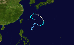
The first tropical cyclone of 1964 developed from a segment of the polar trough. A wind circulation was first identified near Woleai by the JTWC on May9. This initial disturbance traveled west-northwest, passing near Ulithi and Yap.[7]:72 On May14, it organized further into a tropical depression and took an erratic track over the next four days, including a looping course.[30][7]:50,74 During this process, it strengthened into a tropical storm, weakened to a tropical depression, and reattained tropical storm intensity before heading on an east-northwestward to northeastward trajectory.[30][13]:74 On May19, a reconnaissance flight investigating Tess observed two eyes: the first and innermost eye measured 9.7km (6.0mi) across while the second was asymmetrical, with axes roughly 23 and 14km (14.3 and 8.7mi) across.[7]:75 Shortly after finding this feature, Tess was estimated to have attained typhoon status.[30]
Tess tracked towards the northeast after reaching typhoon intensity. Its center passed between Alamagan and Guguan on May20 while maximum sustained winds in the typhoon were 140km/h (87mph).[30] Farther southeast, in Guam, the passing storm produced 52mm (2.0in) of rain.[31] The next day, Tess reached its peak intensity with winds of 155km/h (96mph) and a minimum barometric pressure of 960hPa (mbar; 28.35inHg).[30] A seabee stationed on the island was presumed to have drowned after being swept away by the rough seas generated by the storm; two landing crafts were also destroyed by the rough seas.[32] At noon on May21, the center of Tess passed 160km (99mi) west of Marcus Island,[13]:74 bringing squalls accompanied by heavy rain and winds of 90km/h (56mph).[33][34] Gusts reached 117km/h (73mph) and rainfall accumulations reached 94mm (3.7in) on the island, though there was "little damage."[18] Gradual weakening followed,[13]:74 with winds diminishing below typhoon intensity on May22. The system then began to curve east as it transitioned into an extratropical cyclone by May24, and was last noted three days later.[30]
According to data from the Japan Meteorological Agency (JMA), the progenitor to Typhoon Viola emerged in the South China Sea just east of Vietnam on May21.[35] This system initially moved towards the north before curving sharply east. Three days later, the system organized into a tropical depression after the JTWC identified a surface wind circulation.[7]:81 Viola reached tropical storm strength on May25 and then curved northwest, strengthening further into a typhoon on May27 and peaking in strength with winds of 130km/h (81mph).[35] These winds diminished to 110km/h (68mph)—just under typhoon intensity—as Viola made landfall approximately 160km (99mi) west of Hong Kong at 03:00UTC on May28.[35][13]:74 The storm weakened over mainland China and dissipated on May30.[35]
The Royal Observatory Hong Kong issued typhoon signal No. 8 ahead of Viola's approach, signifying gale-force conditions, a peak gust of over 140km/h recorded in Waglan Island, the highest ever in May. Ferry services were suspended in the territory.[14]:66,74 Hong Kong recorded 300.6mm (11.83in) of rain in five days from the passing typhoon. The rainfall brought an end to an over two-year-long drought that had prompted a year-long water rationing in the territory.[36][37][38]:72 More rain fell in roughly 24hours than in 1964 prior to Viola's arrival.[39] The storm uprooted trees, triggered landslides, and put over 6,000telephones out of commission.[40] Vegetable crops were badly damaged.[41] Viola generated a 0.94-meter-high (3.1-foot)storm surge at Quarry Bay and grounded four ships, including three freighters at Hong Kong.[42][43][13]:74 Forty-one people were hospitalized by the storm and over a thousand were left homeless.[44][41] Further inland, the storm relieved drought conditions in the Chinese province of Guangdong.[43]
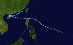
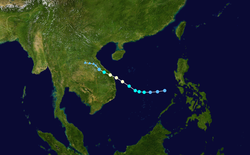
Typhoon Winnie—named Dading in the Philippines[46][16]—originated from a mid-Pacific trough, which organized into a cyclonic circulation on June21 west-southwest of Pohnpei.[7]:86 This initial system moved towards the west-northwest, passing near Ulithi on June25. The next day, the disturbance developed into a tropical depression and gradually took on a more westward course. Winnie reached tropical storm strength on June27 and then typhoon strength on June28 as it rapidly intensified en route to southern Luzon.[45][13]:74 The typhoon attained sustained winds of 165km/h (103mph) shortly before moving ashore Calabarzon on June29;[45] its eye passed directly over Manila.[47] Winnie weakened as it moved over Luzon and restrengthened upon reaching the South China Sea, taking a west-northwesterly heading.[45][13]:74 There, Winnie reached its peak intensity with winds of 185km/h (115mph) and a central pressure of 945hPa (mbar; 27.91inHg). At 00:00UTC on July2, the typhoon made landfall on Hainan southwest of Wenchang with winds of 175km/h (109mph). Winnie weakened to a tropical storm and traversed Hainan and the Gulf of Tonkin before making a final landfall near Haiphong, Vietnam, on July3. Further weakening ensued as the system tracked across northern Vietnam and southwest China before dissipating on July4.[45]
Manila experienced its most damaging typhoon since 1882. Nearly a million people were affected by the storm; according to the U.S. Agency for International Development (USAID), there were 56fatalities and 163injuries as a result of Winnie in the Philippines, with a damage toll of US$8million.[48][49] However, the Associated Press reported 89fatalities on July3 while United Press International reported 120fatalities on July5, with property damage estimated at over $30million.[50][51][52] The Red Cross enumerated 275injuries.[53] Heavy rains from the combination of Winnie and the southwest monsoon flooded entire neighborhoods in Manila.[54] At least 10people were killed by flooding rivers near Manila and in Manila Bay.[47] Approximately 500,000people were rendered homeless in the Manila area and in the central provinces of Luzon following the razing of thousands of homes;[55][13]:74 most of these homes were nipa huts and "makeshift dwellings". Approximately 120,000homes were destroyed in Bataan, Bulacan, and Pampanga.[56] The loss of roofs was widespread.[54] Thousands of trees were uprooted and basic utilities were brought down by the storm;[57] Manila was without power or water for at least 36hours.[53] In Infanta, Quezon, a maximum wind of 127km/h (79mph) was measured.[58] Abaca and coconut plantations in Luzon were seriously impacted. Cargo barges and freighters broke from their moorings and a Philippine Navy destroyer, the RPS Rajah Soliman, capsized while undergoing repairs.[53][47][56] Several aircraft were damaged, including 15C-47 Skytrains at Nichols Field.[47][13]:74 The air traffic control tower at Manila International Airport was put out of commission following wind damage.[47][59] Manila was placed under a state of emergency following Winnie, with government agencies deploying medical and rescue teams to affected areas amid widespread power outages.[53]Catholic Relief Services aided in disaster relief with funding from USAID.[60]South Vietnam delivered 450metric tons (500short tons) of rice to victims of the storm in the Philippines.[61] Dikes and salt fields were damaged in two districts of Nam Định, Vietnam.[62]
On June26, a disturbance formed from an easterly tropical wave southeast of Guam and strengthened into a tropical depression later that day.[63][7]:92 Tracking towards the west-northwest, Alice's intensity fluctuated in its initial stages.[63] On June27, Alice made its closest approach to Guam, passing 95km (59mi) southwest of the island. A peak gust of 59km/h (37mph) was registered on the island, as well as 14mm (0.55in) of rain.[31]:46 The JTWC assessed Alice to have briefly attained typhoon status on June27 with sustained winds of 120km/h (75mph).[63] According to the agency, Alice was the smallest typhoon of 1964, with a radius of 320km (200mi).[7]:47 It rapidly weakened after reaching its peak strength.[7]:50 The storm followed 1,130km (700mi) behind the larger Typhoon Winnie to its west and was eventually absorbed into Winnie's circulation over the Philippine Sea on June29.[63][13]:75
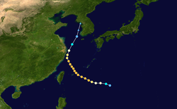
The disturbance that led to Typhoon Betty was first detected in the Philippine Sea on July1 by the JTWC, having developed from a segment of a polar trough within an area of conducive winds in the upper-troposphere.[7]:96 The next day, the disturbance quickly developed into a tropical cyclone and strengthened into a typhoon by the end of July2.[64] Reconnaissance aircraft observed an eye 75km (47mi) in diameter in Betty's first few hours as a typhoon.[7]:98 The storm's winds continued to increase, and on July3 its winds reached 185km/h (115mph) before the rate of intensification stalled.[64] Betty took a northwestward trajectory towards the southern Ryukyu Islands,[13]:75 bringing its eye across southern portions of Miyakojima on July4.[65] There, sustained winds reached 138km/h (86mph), punctuated by a maximum gust of 201km/h (125mph). The island also recorded 124mm (4.9in) of rain from Betty.[66]
After passing the Ryukyu Islands and entering the East China Sea, Betty continued to intensify further, with its sustained winds reaching 205km/h (127mph) on July5.[64] At the time, the typhoon was located approximately 320km (200mi) south of Shanghai.[13]:75 Betty's winds subsequently began to diminish precipitously while the storm curved towards the north and then north-northeast, briefly paralleling the coast of Zhejiang before entering the Yellow Sea.[64][13]:75 Betty degenerated into a tropical storm and further into a tropical depression on July6. It then transitioned into an extratropical cyclone on July7 and dissipated over open waters just off the coast of northwestern South Korea.[64][7]:96
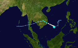
Typhoon Cora developed from the interaction of a polar trough with an easterly tropical wave.[7]:103 A wind circulation materialized from this interaction on July4 west of Chuuk State.[7]:104 On July6, it organized into a tropical depression southwest of Guam,[67][13]:75 prompting the JTWC to initiate warnings.[7]:104 Intensification was rapid upon developing, with Cora becoming a typhoon by the end of July6. Two days later, Cora attained sustained winds of 260km/h (160mph) as it approached the central Philippines on a westward heading, according to the JTWC;[13]:75 this classified Cora as a super typhoon.[7] The eye spanned 6mi (9.7km) across at this juncture.[7]:105 Two consecutive airborne reconnaissance missions into the storm estimated that winds near the surface were around 325km/h (202mph). However, this value was discordant with the 130km/h (81mph) winds occurring at flight level and a surface air pressure of 970hPa (mbar; 28.64inHg) estimated by the flights and by the JTWC. An analysis of the historical tropical cyclone record for the West Pacific published in the Monthly Weather Review concluded that there was "sufficient evidence" that the winds in storms like Cora were "likely overestimated."[68] The Royal Observatory Hong Kong analyzed a substantially lower pressure of 920hPa (mbar; 27.17inHg) at the time of Cora's peak strength.[67]
As Cora neared northern Samar and southern Luzon on July9, its forward motion slowed and its winds unexpectedly diminished and fell below the typhoon threshold.[69][13]:75 Storm warnings were issued in southeastern Luzon with Cora 100km (62mi) east of Samar, with forecasts projecting stormy conditions in the region and in other islands in the east-central Philippines.[70] However, the cyclone's winds continued to lessen before the system reached the islands.[71][72] By July10, Cora had weakened to a tropical depression. It tracked across southeastern Luzon and dissipated in the South China Sea the next day.[67]
The initial system that led to Typhoon Doris began between Pohnpei and Chuuk State on July9.[7] Tracking towards the west-northwest, it passed near Chuuk and became a tropical depression on July11 while 480km (300mi) south of Guam.[73][7][13]:75 Doris became a tropical storm by 12:00UTC that day as it began to track northwest across the Philippine Sea. Early on July13, Doris strengthened into a typhoon while approximately 800km (500mi) east of Luzon.[73][13]:75 The next day, Doris attained one-minute sustained winds of 150km/h (93mph). It weakened as it curved north towards the southern Ryukyu Islands, becoming a tropical storm on July14 and then a tropical depression on July15 while passing near Tarama, Okinawa. The system continued to decay as it moved north and dissipated over the Yellow Sea on July17.[73]
Elsie emerged from a detached portion of a polar trough on July13 near the Northern Mariana Islands; this developed into a tropical depression later that day.[74][7]:115 The depression intensified into a tropical storm two days later, with its course concurrently curving west. Elsie intensified on approach to the Philippines, with the JTWC assessing it as a typhoon on July16.[74] At 04:00UTC the next day, an aerial reconnaissance mission into Elsie estimated that the storm's winds reached 185km/h (115mph).[7]:117 The JTWC determined that this was Elsie's peak intensity.[7]:115 Storm warnings were posted for Luzon on July17 ahead of the storm's approach.[75] The typhoon then weakened rapidly from this peak; upon its landfall on the eastern coast of southern Luzon on July17,[13]:75 it was a 140-km/h (85mph) typhoon, with its intensity lowering to tropical storm status over the island shortly afterwards.[74][7]:50 Rainy squalls associated with Elsie caused extensive flooding in Manila and the northern Philippines, inundating buildings and streets.[76][77] Elsie continued to weaken after emerging into the South China Sea and dissipated on July19.[74]
The initial vortex that became Typhoon Flossie was detected east of Luzon on July24,[7]:121 embedded within an area of low pressure.[13] It moved towards the northeast across the Philippine Sea and became a tropical depression on July25.[78][7]:121 It became a tropical storm the next day as it curved northwest, passing south of Okinawa and intensifying into a typhoon shortly afterwards in the East China Sea. On July28, Flossie continued to curve towards the north, passing just offshore the eastern coast of China near Shanghai. Flossie reached its peak strength during this time with winds of 150km/h (93mph). After traversing the Yellow Sea, Flossie made landfall on North Korea along the coast of the Korean Bay on July29 with winds estimated at 100km/h (62mph). The storm weakened over land, passing over southeastern Manchuria and Siberia, and was last monitored over Sakhalin.[78][13]
Flossie's peak winds were approximately 75km/h (47mph) at the time of its closest passage to Okinawa, as measured by both aircraft reconnaissance and the USS President Roosevelt.[78][13]:75 The U.S. Navy ships George Clymer and the El Dorado collided at Okinawa amid Flossie's gale-force winds;[79][13]:75 one ship sustained a hole 0.9m (3.0ft) wide in her bow.[80] A third ship, the USS Weiss, ran aground at Buckner Bay after the storm separated the ship from its anchorage.[81][13]:75 The USS Tawasa was dispatched to tow the stricken Weiss out to sea, but was itself grounded on an unforeseen pinnacle upon dislodging the Weiss.[82] Flossie destroyed 15fishing boats and drowned 12fishermen off the western coast of the Korean peninsula; another 27fishermen was listed as missing.[83][84] At least 17people overall were killed by the typhoon on the peninsula.[85]
Tropical Storm Grace was the first of ten tropical cyclones in the 1964typhoon season discovered by meteorological satellites.[12] Upon its detection, it was 1,000km (620mi) southeast of Okinawa.[87] The precursor disturbance formed on July25 and took an initially northward track, veering west and organizing into a tropical depression on July26. Grace became a tropical storm the following day and ultimately attained maximum sustained winds of 95km/h (59mph) on July28 while situated in the central Philippine Sea. The storm then began to take an erratic path that continued for the next three days.[86] During this period, the JTWC considered Grace to have temporarily lost its tropical cyclone status,[7]:61 becoming an indescript collection of squalls.[23] After taking a northward heading, Grace redeveloped on August3 and tracked across the Satsunan Islands. On August4, the storm weakened and dissipated west of Kyushu.[86]
Helen began within a region of sparse weather observations east of the Northern Mariana Islands on July27, starting with a northward track that curved towards the northwest.[88][13]:75 Helen became a tropical storm by 18:00UTC on July27 and then reached typhoon strength by 06:00UTC on July29. The JTWC assessed Helen to have reached its peak intensity on July30 with sustained winds of 240km/h (150mph) and a central pressure of 930hPa (27.46inHg).[88] The typhoon passed within 160km (99mi) of Iwo Jima around noon that day.[13]:75 An aircraft reconnaissance mission observed two concentric eyewalls spanning 11 and 80km (6.8 and 49.7mi) across.[7]:129 Helen moved across the northern Ryukyu Islands and southern Kyushu on August1 and entered the Yellow Sea as a weakened typhoon.[88][13]:75 The nexr day, the center of Helen moved over Jeju-do with winds of 150km/h (93mph) as estimated by the JTWC.[88] Winds of 135mph (217km/h) were experienced on the island.[89] On August3, Helen weakened to a tropical storm and made landfall near Dalian in Liaoning. The system curved towards the north and east before dissipating in the Sea of Okhotsk on August5.[88]
Winds near the center of Helen were approximately 185km/h (115mph) as it crossed the northern Ryukyu Islands and Kyushu.[13] High waves and strong winds impacted southern Kyushu across the prefectures of Kagoshima and Miyazaki, unroofing homes and flooding nearly 200 homes.[90] In the city of Kagoshima, 16homes were razed and 36others were damaged.[91] Regional disruptions to power, train, and ferry service resulted from the storm's passage.[92] One death and 16injuries were reported in the two prefectures.[93] An F1 tornado associated with the typhoon occurred south of Takanabe, Miyazaki, without causing casualties.[94][95] Rough surf from Helen reached the Tokyo area, drowning 13people.[96][92] Helen killed at least nine people in South Korea;[97] 3drowned and 15others were missing following the sinking of a fishing boat off the southern coast.[98]
The origins of Typhoon Ida were associated with the interaction between a polar trough and a tropical wave, which resulted in the development of a tropical disturbance south of Chuuk State on August1.[7]:134 The disturbance became a tropical depression roughly (300mi) southeast of Guam on August2 and strengthened into a tropical storm later that day. Tracking towards the west-northwest, Ida reached typhoon intensity on August4.[13] According to the JTWC, Ida reached its peak intensity with maximum winds of 250km/h (160mph) and a central pressure of 925hPa (mbar; 27.31inHg).[99] Between August6–7, Ida moved across northern Luzon with these winds. The storm weakened over the island but restrengthened over the South China Sea on approach to Hong Kong. The center of the storm passed 65km (40mi) southwest of Hong Kong and made its final landfall on Guangdong Province China on August8 as a typhoon with winds of 150km/h (93mph) as estimated by Royal Observatory Hong Kong. As it tracked farther inland, Ida weakened and later dissipated on August12.[99][13]
Eleven deaths in Luzon were attributed to Ida according to data from the Office of Foreign Disaster Assistance, in addition to flooding and crop damage throughout the island.[13][100] Newswires reported disparate death tolls, with the Associated Press reporting 14fatalities, the Philippine News Service reporting 23, and United Press International reporting 79.[101][102] The damage toll was around US$25million.[103] Several fishermen also went missing during the storm;[104] 31went missing after the presumed sinking of ship off the coast of southeastern Luzon.[102] Most communications were disrupted across northern Luzon.[105]U.S. Navy ships stationed at U.S. Naval Base Subic Bay were evacuated into the South China Sea prior to the storm's arrival and people in low-lying fishing villages left for higher ground.[106][105] A 3,541-short-ton (3,212-metric-ton) freighter sustained damage to its bilge upon being grounded near Aparri.[13] Streets in Manila were flooded to waist-height from heavy rains and high waves.[105][107] Two people drowned after their ship sink off Kaohsiung, Taiwan, while four people went missing after their fishing boat sank offshore Taiwan.[108]
In Hong Kong, the Royal Observatory advised ships to seek shelter in port and issued typhoon signal no. 9 at the height of the storm.[109][110] Approximately 11,000people were evacuated from low-lying areas.[111] Gusts of 220km/h (140mph) reached the Crown colony, flattening over 200homes; three people were killed and six were injured by flying debris.[13][112] Signboards and trees were also brought down by the typhoon's winds.[113] At Quarry Bay, Ida produced a storm surge of 1.31m (4.3ft).[42] An 11,360-ton freighter ran aground at Victoria Harbour, where two people drowned.[13][112] The Royal Observatory documented rainfall rates as high as 230mm (9.1in) per hour from Ida.[114] Four people were killed after a mudslide pushed into a refugee camp and razed three houses Kwun Tong, with the 20,000m3 (710,000ft3) surge of mud placing areas under 7.5m (25ft) of debris.[111][115] Over 100refugees were injured and 5,000were left homeless by the mudslide.[36][111] Another seven people were killed in Korea following rains associated with Ida.[111] At least 4,000others were rendered homeless by the resultant flooding.[101]
Tropical Storm June began south of Guam as a disturbance on August9. Traveling west-northwest, it became a tropical depression by the time aircraft reconnaissance first reached the system on August10.[116][23] Later that day, June attained a tropical storm and reached its peak intensity with winds of 75km/h (47mph). The storm held this intensity for a day before weakening as it neared Luzon contrary to forecasts projecting June to become a typhoon.[116][117] The JTWC issued their last warning on the system on August11 and considered the system to have dissipated two days later when it was north of Luzon and east of Batan Island.[23][116][7]:63 However, data from the CMA and JMA indicates that June persisted as a tropical depression into the South China Sea and took a looping course near Hainan and the Leizhou Peninsula. It then turned northeast and dissipated near the Taiwan Strait on August18.[116]
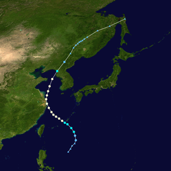
According to the JTWC, Kathy was both the largest and longest-lived typhoon in 1964, with the agency issuing warnings for 13.5days and the storm's circulation reaching a diameter of 1,575km (979mi).[7]:59 The interaction of a polar trough and easterly wave led to the genesis of a vortex southeast of Japan by August11.[7]:141 This system developed into a tropical storm the next day east of Iwo Jima based on ship observations.[118][13]:76 Maintaining a west-northwestward heading, Kathy reached typhoon strength on August13,[118] passing well south of Tokyo on approach towards the Ryukyu Islands.[119][120] The typhoon's winds peaked at 165km/h (103mph) on August14 before tapering as the storm curved towards the west-southwest.[118][13]:76 For the next four days, Kathy and nearby Typhoon Marie began a Fujiwhara interaction, causing both storms to rotate around one another, ending when Marie was absorbed into Kathy's circulation.[7]:50 Between August15–16, Kathy briefly fell to tropical storm intensity before regaining typhoon status southeast of Amami Ōshima.[118] During this period, an airplane investigating the storm identified multiple wind circulations at the center of Kathy and the storm's clouds were asymmetric.[121][7]:146
The storm's west-southwest path brought the center across the Ryukyu Islands and near Okinawa on August16 as Kathy began to execute a counterclockwise loop in its track. Two days later, Kathy's winds were estimated by the JTWC to be around 215km/h (134mph) near Minamidaitōjima. The typhoon's track made a smaller counterclockwise loop on August20 before resuming north across the northern Ryukyu Islands. On August23, Kathy made landfall on Kagoshima Prefecture with winds of 130km/h (81mph) and weakened to a tropical storm as it crossed the Seto Inland Sea and southern Honshu. It then curved to the northeast, briefly entering the Sea of Japan and crossing the Noto Peninsula before traversing northern Honshu and emerging into the northern Pacific.[118][13]:76 On August25, Kathy transitioned into an extratropical cyclone and continued northeast towards the Aleutian Islands before it was last in the Bering Strait on September1.[118][13]:76
According to the publication Climatological Data, Kathy caused at least 13deaths and "numerous" injuries, with landslides and flooding being the principal cause of the casualties; as much as 700mm (28in) of rain was documented in the mountainous regions of Kyushu, though cities averaged 100m (3,900in) in rainfall accumulations.[122][13]:76 United Press International reported as many as 24fatalities and 8missing persons associated with the typhoon,[123][124] with the Associated Press documenting 28injuries.[125] Over 4,000people were rendered homeless.[125] Kathy's effects flooded almost 1,700homes and destroyed 8others in Amami Ōshima; winds there reached 138km/h (86mph).[126][127] Sustained winds topped out at 126km/h (78mph) with a peak gust of 195km/h (121mph) on Yakushima.[128] As Kathy moved across southern and central Kyushu, damage was reported in Kagoshima, Kumamoto, Miyazaki, and Oita prefectures. Kathy's winds razed 44houses and damaged 80houses, with another 5,500 flooded by swollen rivers. Flooding broke through river embankments in 37locations and washed away 18bridges. Telecommunications and transportation services were disrupted with roads damaged in 400locations.[129][124][130] There were at least 238landslides caused by the typhoon, including one that derailed a passenger train in Oita Prefecture.[129][131] One landslide in Kagoshima killed 11people.[132] Two thousand homes were flooded farther north in Fukushima Prefecture.[133] The extratropical remnants of Kathy brought gale-force winds over the Bering Sea.[13]:76
Lorna began west of the Mariana Islands on August10 and took a northeastward path throughout its duration. Its precursor disturbance developed from a trough of low pressure and became a tropical depression by August12; the next day, Lorna became a tropical storm, prompting JTWC warnings.[134][24][7]:63 According to the JTWC, Lorna's winds topped out at low-end tropical storm speeds, 65km/h (40mph), for less than a day before it began to weaken. Lorna dissipated on August14 north of Agrihan.[134]
The combination of converging low-level winds and divergence in the upper troposphere over the Philippine Sea led to the environmental conditions that resulted in the formation of Typhoon Marie. The initial disturbance formed on August12 and tracked towards the north and then curved east, becoming a tropical depression the next day. Marie intensified into a tropical storm by August15 and then curved north as it interacted with nearby Typhoon Kathy.[135][26][25][7]:155 Two days later, it became a typhoon and subsequently reached its peak intensity with winds estimated by the JTWC at 130km/h (81mph) and a central pressure estimated by the JMA of 980hPa (mbar; 28.94inHg). The storm then weakened and curved towards the west; the JTWC determine Marie to have been absorbed by Typhoon Kathy approximately 240km (150mi) north of Okinawa on August18.[135][13]:76[7]:155 However, the CMA and JMA assessed Marie to have remained intact, continuing on a curved path towards the south and then east, bringing it around Okinawa as a tropical cyclone until its dissipation on August20.[135]
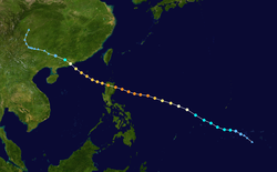
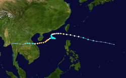
The tropical disturbance that organized into Ruby arose from a tropical wave west of Saipan on August29.[7] It became a tropical storm over the central Philippine Sea on September1 and took a slightly south of west heading, strengthening into a typhoon on September2 and passing over the Babuyan Islands of the Philippines the following day; one-minute sustained winds at the time were estimated to be 140km/h (87mph).[136][137] After reaching the South China Sea, Ruby turned towards the northwest and intensified further. On September5, Ruby attained maximum one-minute sustained winds of 220km/h (140mph) as it made landfall near Hong Kong and Macau. The CMA and HKO estimated a central pressure of 960hPa (mbar; 28.35inHg) during Ruby's landfall. After moving inland, the storm weakened and dissipated over South China on September6.[136][13][7]
Ruby was the first of two typhoons in 1964 for which the Royal Observatory in Hong Kong raised tropical cyclone signal no. 10; this warning was in effect for nearly four hours.[137][14] The fastest wind gust from Ruby in Hong Kong was clocked at 268km/h (167mph) at Tate's Cairn.[138] A gust of 230km/h (140mph) on Waglan Island was the fastest observed in the island's history.[139] The strong winds and heavy rain caused widespread damage in Hong Kong, destroying thousands of homes and damaging thousands of others.[14][140] Fifty thousand refugees from the People's Republic of China lost their shelters.[141]:1 Numerous ships sank or ran aground at the Hong Kong Harbor.[14][141]:2 There were 38fatalities and 300injuries in the Crown colony.[14] A record gust of 211km/h (131mph) was measured in Taipa, Macau.[142] There, more than 20people were killed and 100others were injured.[143] Widespread flooding and damage occurred in Guangdong Province, leading to the deaths of over 700people; some 300people died when a school dormitory collapsed.[144]
Sally's precursor arose from a tropical wave near the Marshall Islands on September2.[7]:168 The disturbance became a tropical depression and later a tropical storm the next day approximately 320km (200mi) northeast of Chuuk State.[13]:76 On September4, Sally intensified into a typhoon and passed over Guam the next day with one-minute sustained winds of 155km/h (96mph).[31][145] On September7, Sally reached its peak intensity over the Philippine Sea with winds of 315km/h (196mph) and a central pressure of 895hPa (mbar; 26.43inHg).[145] Based on data from the JTWC, Sally was the strongest typhoon of the 1964season along with Typhoon Opal as measured by maximum winds, and had the lowest pressure of any storm that year.[7]:47 Weakening commenced thereafter as the center of Sally passed north of Luzon on a west-northwestward heading on September9.[146][145] At 15:00UTC on September10, Sally made landfall on China east of Hong Kong with one-minute sustained winds of 155km/h (96mph). The storm weakened into a tropical storm later that day and dissipated over China on September11.[7][13][145]
Sally inflicted around $115,000 in damage in Guam, mostly to crops, after bringing gusts of 130km/h (81mph) to the island and unroofing homes and felling trees.[147][31] The damage remained limited to the southern half of Guam where the storm struck;[148] there were no casualties.[149] Sally produced strong winds and heavy rains to the Philippines north of Manila, causing considerable damage.[146][150][100] Over 10,000people were evacuated out of vulnerable areas in Hong Kong as the storm was feared to strike with a severity comparable to Typhoon Ruby a week prior.[151][152][153][154] Gusts peaked at 154km/h (96mph) at Tate's Cairn and rainfall accumulations reached as high as 354.4mm (13.95in), triggering landslides that killed nine people.[155][151] However, Sally's impacts on the Crown territory were less than initially feared;[156] much of Hong Kong's vulnerable agriculture was already badly damaged during Ruby's passage.[155] The remnants of Sally led to the heaviest rainfall in the Seoul area in 22years, producing 125–200mm (4.9–7.9in) of rain in the area on the morning of September13.[13][157] The resulting floods killed at least 211people and injured 317others.[158] Local authorities reported the inundation of 9,152homes and the displacement of 36,665people;[159] total property damage amounted to $750,000.[160]
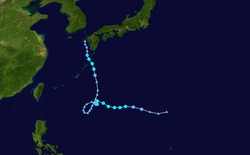
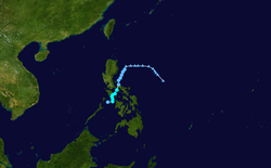
The precursor disturbance to Tilda was identified northwest of Guam using the Automatic Picture Transmission system during the 10-day operational lifespan of the Nimbus 1 satellite.[7]:14 The initial vortex that became Tilda formed by September12 and organized into a tropical depression by September13.[7]:177[13]:76 Tilda's winds reached typhoon intensity on September14. Its center passed over the Bataan Islands the same day before moving west into the South China Sea.[13]:76 According to the JTWC, Tilda's one-minute maximum sustained winds crested at 165km/h (103mph) before their speeds began to decrease.[161] On September16, the center of Tilda passed 95km/h (60mi) south of Hong Kong.[13]:76 Tilda's close pass of Hong Kong prompted the hoisting of storm signals to warn ships and small craft,[162] with the Royal Observatory escalating its warnings to typhoon signal no. 3.[14] The typhoon then became stationary for nearly two days over the South China Sea with its winds concurrently falling to tropical storm intensity according to the JTWC.[13]:76 Tilda's meandering path disrupted shipping and led to the Royal Observatory keeping storm signals active for a record 161hours.[163]
On September19, the JTWC determined that Tilda reintensified into a typhoon after the storm began to move west.[13]:76 The typhoon's one-minue sustained winds were estimated by the agency at 205km/h (127mph) on September20 before weakening ensued.[161] Tilda made landfall on the coast of Vietnam on September22 roughly 95km (59mi) northwest of Huế, Vietnam, and 200km (120mi) north of where Typhoon Violet struck a week prior.[13]:77[164]:76 Storm surge at Lăng Cô reached 1.7m (5.6ft).[165] Tilda continued inland and weakened before dissipating by September25.[7]:14 Rainfall from Tilda led to some of the largest flood depths and durations on record in the drainage basin of the Mekong River;[164]:37 the longevity and spatial extent of Tilda's rains were also near world-record-levels.[164]:77 The highest rainfall total over a three-day period was 470mm (19in).[164]:136 Precipitation totals were enhanced by orographic effects on southwest-facing slopes in southwestern Laos near the Thailand border.[164]:44 Most buildings at the U.S. Marines base in Da Nang sustained water damage and lost power for over a week.[166] At least three people went missing in Thailand following the flooding from Tilda. Water inundation reached 0.6m (2.0ft) in some cities and railways and highways suspended traffic.[167][168]
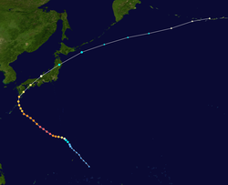
According to data from the JMA, Wilda began as a tropical storm east-southeast of Guam on September16, marked by a large mass of clouds and associated rainbands.[169][170]:141 The system tracked northwest over the Northern Mariana Islands and into the Philippine Sea two days later.[169] The JTWC recognized the storm as a tropical cyclone on September19 when it was located roughly 370km (230mi) northwest of Saipan, and assessed Wilda to have strengthened into a typhoon later that day.[13]:77 An eye emerged on Nimbus satellite imagery on September20,[170]:159 and on September21, Wilda reached its peak intensity over the Philippine Sea with one-minute maximum sustained winds of 280km/h (170mph) as estimated by the JTWC and a minimum central pressure of 895hPa (mbar; 26.43inHg).[169] Based on data from the JMA, this was tied for lowest central pressure of any typhoon in 1964, along with Typhoon Sally.[171] Wilda slightly weakened following peak strength before curving northward and making landfall on Kagoshima on September24; one-minute sustained winds three hours prior to landfall were estimated to be 185km/h (115mph).[169] The storm passed over Shikoku and southern Honshu before emerging into the Sea of Japan and curving northeast. Wilda made a final landfall on the western coast of northern Honshu on September25 as a tropical storm, thereafter departing Japan and quickly moving towards the central Aleutian Islands as a powerful extratropical cyclone.[169][13]:77 The storm was last identified on September27.[169]
Wilda was one of the strongest typhoons to ever strike Japan as measured by atmospheric pressure, reaching Cape Sata in Kagoshima with a central pressure of 940hPa (mbar; 27.76inHg).[172] The typhoon caused 47fatalities and 530injuries in Japan. Over 70,000homes were destroyed and nearly 45,000were inundated by the typhoon across the country,[173] leaving thousands of people homeless.[174] The southern and eastern coasts of Kyushu, the southern coast of Shikoku, and Hyōgo Prefecture experienced the highest proportion of destroyed homes per capita.[175] At least 64ships were sunk with another 192damaged or lost.[176] Damage was widespread in the northern Ryukyu Islands.[13]:77 Banana, sugar cane, and vegetable fields in Amami Ōshima were badly damaged, along with roofs and windows. Naze lost power during the storm. Wilda brought 6-meter (20-foot) waves to southern Kyushu.[177] One British freighter ran aground off Kagoshima and broke into two; all 41crew were rescued.[178] The widespread flooding in the region overtopped dikes and disrupted air and rail traffic.[179] At Uwajima, Ehime, a peak wind gust of 259km/h (161mph) was observed;[175] this was the strongest wind recorded in connection with the Wilda in Japan.[180] An 8,547-ton Indonesian freighter with 53crew ran aground and keeled over at the Port of Kobe.[181][182] Gale-force winds from Wilda reached the Tokyo area, damaging roofs at the Tokyo Olympic Village and uprooting trees two weeks before the start of the 1964 Summer Olympics.[183][184][185] A ship just south of Tokyo Bay reported winds of 76km/h (47mph).[13]:77
Tropical Storm Anita formed just west of Luzon on September23. It initially tracked towards the southwest and attained tropical storm intensity in the central South China Sea on September25 according to data from the JTWC. Its intensity oscillated as curved west and neared central Vietnam, peaking in strength with winds of 95km/h (59mph) on September26; these winds were inferred from maritime observations near the storm. The following day, Anita made landfall near Da Nang, Vietnam, and later weakened over land; the storm dissipated on September28.[186][187]:52
Tropical Storm Billie began southwest of Guam on September24.[188] The JTWC detected the system based on surface observations the next day while the system was centered 480km (300mi) southwest of Guam. Billie reached tropical storm intensity on September27 as it moved west. While the system may have degenerated into an open trough of low-pressure on September28 amid strong easterly winds, it quickly reorganized and strengthened further before tracking across southern Luzon from Catanduanes to just south of Manila with winds of 85km/h (53mph). Bille emerged into the South China Sea thereafter, where its winds topped out at 110km/h (68mph). The center of the tropical storm passed south of Hainan on September30 and made landfall on Vietnam on October1. Billie had already begun to weaken on approach to land but diminished further once over Southeast Asia; the storm and its remnants continued tracking west into Myanmar before dissipating on October3.[188][187]:53
Sixteen people were killed by floods triggered by Billie's rains in Camarines Sur. The torrents destroyed homes and left 10,000families homeless.[189] Flooding swept away a bridge along a railroad of the Philippine National Railways, causing a passenger car to derail; one person was injured. The Manila area also experienced widespread floods.[190] Property damage from the tropical storm totaled US$3million.[189]
Clara formed southwest of Guam on October1 from a separating portion of a trough and initially moved towards the northwest.[191][7]:86 Weather observations near the storm at the time of its formation were sparse.[13]:77 The JTWC assessed the system to have reached tropical storm status on October2. Continuing to intensify, Clara curved west over the central Philippine Sea on October3 and strengthened into a typhoon the next day according to data from the JTWC. Clara's winds topped out at 150km/h (93mph) as it made landfall on the coast of Aurora at Dilasac Bay on October5.[191][13]:77 Warnings were raised for Clara across parts of eight Filipino provinces ahead of the storm's approach.[192]
Clara weakened over Luzon but remained a typhoon upon emerging into the South China Sea, where it eventually reattained one-minute sustained winds of 150km/h (93mph). Tracing a path similar to Tropical Storm Billie a week prior, the center of Clara passed south of Hainan on October7. The storm weakened within the Gulf of Tonkin and struck Vietnam north of Đồng Hới on October8 with one-minute sustained winds estimated at 85km/h (53mph) by the JTWC. The cyclone weakened inland and rapidly dissipated over Thailand on October8.[191][13]:77
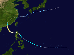
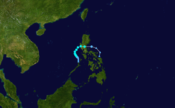
Dot originated from the interaction of a trough of low-pressure and a tropical wave west of Pohnpei in early October.[193][7]:205 Aircraft reconnaissance first encountered the system on October6, finding a developing tropical storm 160km (99mi) southwest of Yap.[13]:77 Dot traveled on a west-northwestward heading and curved gradually towards the northwest, becoming a typhoon on October9. Dot then curved towards the west and made landfall on northern Luzon the following day with one-minute sustained winds of 130km/h (81mph).[193][13]:77 The storm continued to strengthen once it emerged into the South China Sea, and reached its peak intensity with one-minute sustained winds of approximately 165km/h (103mph) on October11.[193] Dot then curved slowly northward and moved ashore China just east of Hong Kong on October13 at largely the same intensity.[194][13]:77 The storm then quickly weakened inland, transitioning into an extratropical cyclone on October15 and curving northeast back into the Pacific before it was last noted off Japan on October19.[193]
Dot was the fifth typhoon in 1964 to hit Hong Kong.[13]:77 Its proximity to the Crown colony led to the issuance of tropical cyclone signal no. 10 from the Royal Observatory and forced the suspension of public transportation and incoming flights.[194][138][195][196] The Royal Observatory recorded 331.2mm (13.04in) of rain and gales for eight consecutive hours.[194][197] At Tate's Cairn, a maximum wind gust of 220km/h (140mph) was measured.[138] Numerous rain-triggered landslides destroyed homes and blocked roads, resulting in most of the casualties associated with the typhoon.[163][198][196] The official death toll from the storm in Hong Kong enumerated 26fatalities and 85injuries with 10unaccounted for,[14]:74 though press reports at the time indicated a higher death toll.[199] Total property damage was estimated to be in the millions of U.S. dollars.[200]
Tropical Depression 37W formed west of Kawalein on October 8, peaking at a 50mph (80km/h) tropical storm, per JTWC, and was given the name Ellen. Ellen dissipated on October 10 near Ponape.
Fran began its development northwest of the Marshall Islands around October13.[202] Aircraft reconnaissance reached the system on October15, encountering as a westward-moving tropical storm. Fran then took a more northward heading, and only October17 attained peak one-minute sustained winds of 95km/h (59mph) approximately 650km (400mi) west of Wake Island according to the JTWC. Thereafter, the storm began to take on extratropical characteristics, with its center of circulation enlarging and becoming irregular.[203][202] Fran continued north before curving east after October20, eventually transitioning into an extratropical system by October21 and dissipating on October23 over the open Pacific.[202]
Tropical Storm Georgia was first observed as a tropical depression 360km (220mi) south-southwest of Guam on October17. The nascent cyclone did not organize further, with aircraft reconnaissance unable to locate the storm's central vortex. However, the system became more pronounced on October20 as it tracked towards the west-northwest, and became a tropical storm on October21 near the Philippines. At around 06:00UTC on October21, Georgia made landfall on Luzon at Lamon Bay and passed north of Manila; one-minute sustained winds associated with the storm at the time were around 65km/h (40mph). It then crossed into the South China Sea where intensification continued as the Georgia's one-minute sustained winds reached 85km/h (53mph). The tropical storm passed south of Hainan and made landfall on Vietnam near Vinh on October23, after which it dissipated.[203][204]
Typhoon Hope originated around October21 near the island of Pohnpei, tracking west at tropical depression intensity for three days.[205] On October24, when it was west of Guam, the JTWC upgraded the system to tropical storm status based on aerial observations of the system.[205][13]:77 Hope continued to track west before curving north on October25 towards an eventually northeastward track. On October27, Hope became a typhoon northwest of the Bonin Islands as it accelerated northeast.[13]:77 This intensification was attributed to the instrusion of colder air into the typhoon's circulation, causing a surge of winds in the lower levels of the atmosphere during a relatively short timeframe.[206][7]:21–25 Though winds as high as 240km/h (150mph) were estimated by aircraft reconnaissance investigating the typhoon during this period,[13]:78[7]:214 Hope's one-minute sustained winds in the JTWC's tracking data peaked at 140km/h (87mph).[205]
The typhoon gradually weakened thereafter, but continued to produce strong winds and waves 8.2m (27ft) high. On October29, the storm weakened to tropical storm strength and later transitioned into an extratropical cyclone. The extratropical cyclone intensified on approach to the central Aleutian Islands and later became part of a broader cyclonic system within the Bering Sea.[13]:78
On November1, the JTWC began monitoring a tropical disturbance over the South China Sea, near the western Philippines. The following day, the system quickly organized as it moved in a general eastward direction. During the afternoon, the JTWC issued their first advisory on the system, immediately declaring it Tropical Storm Iris. After briefly taking a northeasterly track, Iris turned towards the southeast and reconnaissance planes recorded a developing eyewall. The following day, the a pressure of 1000mbar (hPa) was recorded in the center of the storm; however, this reading was not taken at the storm's highest intensity.[208] On November4, Iris intensified into a minimal typhoon, attaining winds of 120km/h (75mph)[209] and featured a circular 18mi (29km) wide eye. Several hours later, the storm made landfall in central South Vietnam at this strength. Rapid weakening took place shortly thereafter, with the storm dissipating late on November4 over the high terrain of Vietnam.[208]
Tropical Storm Iris brought significant rainfall to parts of Vietnam, resulting in significant flooding. However, a few days after Iris moved through the country, Tropical Storm Joan worsened the situation significantly.[210]
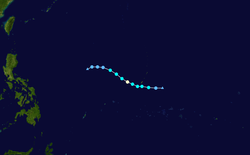
The deadliest storm of the 1964 season, Tropical Storm Joan brought heavy flooding that killed 7,000 people in Vietnam.[210]
Similar to the formation of Tropical Storm Iris, Tropical Storm Joan originated from a tropical disturbance over the western South China Sea on November5. Tracking eastward, the system quickly organized and was immediately declared a tropical storm on November6. Early the next day, a reconnaissance plane recorded a pressure of 1000mbar (hPa), the lowest in relation to Joan; however, this was measured while the system was a minimal tropical storm. Continued development took place over the following day as a well-defined wall cloud developed within the system.[212] Joan attained typhoon intensity during the afternoon of November8 and reached its peak intensity with winds of 130km/h (81mph) shortly thereafter.[213] Tropical Storm Joan made landfall in nearly the same location as Typhoon Iris in central Vietnam before rapidly weakening over land. The system eventually weakened to a tropical depression on November9 before dissipating over Laos.[212]
Due to the rapid succession of tropical storms Iris and Joan, widespread flooding and catastrophic flooding was reported across central South Vietnam. Roughly 90% of structures in three provinces were damaged by the storms and nearly one million were estimated to have been left homeless. Military operations during the Vietnam War were suspended by the typhoons.
A tropical wave was spotted off South Vietnam on November 12. The wave became Tropical Depression 45W on the 13th. The depression quickly strengthened into Tropical Storm Kate the same day. Kate made a curve to the west as a 60mph (97km/h) tropical storm. Kate strengthened into a typhoon on the 15th and a peak at 90mph (140km/h) winds the next day. Kate made landfall over South Vietnam on the 17th, dissipating over land.
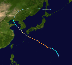
Louise began as a cyclonic vortex associated with a tropical wave near Yap State on November12.[13]:83[7]:232 Two days later, the system became a tropical depression, and reached tropical storm intensity on November15.[215] This initial tropical cyclone was named Louise by the JTWC.[7] Louise became a typhoon the next day and passed 22km (14mi) south of Angaur with one-minute sustained winds estimated at 185km/h (115mph).[216][215][13]:78 Louise continued to intensify after passing the island, and attained its peak intensity on November18 with one-minute sustained winds of 305km/h (190mph) and a central air pressure of 915hPa (mbar; 27.09inHg).[215] Louise was unusually close to the equator for a storm of its intensity; persisting at a strength equivalent to a Category5 hurricane on the Saffir–Simpson scale at 7.3°N, closer to the equator than any other Northern Hemisphere tropical cyclone of such intensity.[217] On November19, Louise made landfall on Lanzua Bay in Surigao del Sur, Philippines, with winds of approximately 260km/h (160mph).[13]:78[215] Meteorological agencies disagree on the evolution of Louise after landfall, with the JTWC and JMA determining that it dissipated on November21, while the CMA lists that it tracked across Luzon and eventually dissipated in the South China Sea by November26, as Marge.[203]
Anguar and Peleliu suffered widespread damage with the toll ranging between US$50,000–US$500,000. On Peleliu, 97percent of structures were destroyed, while 90percent of homes on Anguar were destroyed.[218][219] The loss of homes on the two islands displaced 178families.[220] One person was killed and four people were injured.[218] The U.S. Weather Bureau called Louise one of the most destructive storms ever documented in the central Philippines.[13] At least 576people were killed, though the Philippine Red Cross recorded 631fatalities, along with 157missing people and 376,235people displaced by the typhoon.[13][221] Nineteen Philippine provinces were impacted by the storm.[222] Widespread destruction occurred in Surigao City, where the storm killed 312people and caused US$12.5million in damage.;[223][224] Several ships sank during the storm, contributing in part to the death toll.[13][225][226][227] A state of calamity was declared for Surigao del Norte,[228][229] prompting an intense relief effort amid an ongoing cholera epidemic and unrelated flooding.[226][230][231] In June1966, the Congress of the Philippines authorized ₱3.4million to be distributed annually through fiscal year 1969-70 for the province and its municipalities.[232]
Meteorological agencies disagree on the formation of Marge, after landfall, with the CMA listing Marge as a continuation of Louise,[215] and the JTWC and JMA determining that a second distinct tropical cyclone east of the Philippines formed concurrently.[233][234] This storm tracked across Luzon and eventually dissipated in the South China Sea by November26.[203]
Nora began within the Sulu Sea near the Cagayan Islands sometime around November26–27, and became a tropical storm shortly after it was first detected.[235][203] The storm tracked towards the northeast and reached its peak strength on November27 with one-minute sustained winds estimated by the JTWC at 100km/h (62mph). Nora then curved northwest before moving ashore Mindoro in the Philippines on November28.[235] The storm then weakened to a tropical depression and strengthened no further, though data from tracking agencies disagree on Nora's demise, with the HKO and JTWC analyzing the storm to have dissipated in the direction of the South China Sea while the CMA and JMA indicating that the system continued northeast across the Philippines before dissipating over the Philippine Sea.[235] Rough waters kicked up by the storm led to the sinking of a cargo ship near Zamboanga City, causing the presumed drownings of 18people; another 37crewmembers were rescued.[236]
Opal formed from a tropical wave moving through the Caroline Islands in early December, with an initial wind circulation developing by December8.[7]:239 The newly formed system organized quickly; by the time a reconnaissance aircraft encountered the system 160km (99mi) southwest of Chuuk Lagoon on December9, Opal was already a typhoon with an eye spanning 40km (25mi) across.[13]:78[7]:47 Between December10–12, Opal moved between Yap and Palau, passing 65km (40mi) north of Kayangel with one-minute sustained winds of 260km/h (160mph).[13]:78[216] On December12, Opal reached its peak intensity with one-minute sustained winds of 315km/h (196mph) and a central pressure of 895hPa (26.43inHg).[237] Data from the JTWC indicated that Opal's winds, along with Sally earlier in the year, were the highest of any typhoon in 1964. Opal also had the largest wind circulation of any typhoon in 1964, with a total span of 2,100km (1,300mi).[7]:47 On December14, the typhoon passed north of Catanduanes and Polillo Island and its winds began to lessen. Later that day, Opal made landfall on central Luzon with one-minute sustained winds of 140km/h (87mph). The typhoon weakened further as it moved over Luzon. Its center then executed a small counterclockwise loop over western Luzon before curving north and briefly emerging into Lingayen Gulf as a tropical storm. Opal crossed northwestern Luzon and the Babuyan Islands on December16 and later became extratropical near Okinawa on December17; this phase of Opal's development dissipated the next day.[13]:78[237]
Opal inflicted minor damage to a few homes in Palau, where winds reached an estimated 140km/h (87mph). Tent homes in Angaur and Peleliu were inundated by storm surge.[238] The Philippine Weather Bureau initially issued storm warnings for the eastern Visayas and Mindanao on December13 in anticipation of Opal;[239] these warnings were later extended to southern and central Luzon.[240]Philippine Airlines cancelled all flights scheduled for the afternoon of December14 and the U.S. military moved its Luzon-based aircraft to safety.[241]Manila International Airport closed and railways were brought to a standstill.[242][243] Some schools and offices in Manila were forced to close due to Opal's rains.[244] The total cost of damage caused by Opal in the Philippines was estimated at US$25million.[245] Two people were killed and another three were injured in Virac, Catanduanes, after their house was razed by a landslide caused by torrential rainfall.[246][247] Opal caused significant property damage in Luzon and disrupted communications.[13]:78[248] Rice crops were damaged by heavy rainfall, and together with coconut crops, sustained losses estimated in the millions of U.S. dollars.[13]:78[249] These crop losses were most severe in central and southeast Luzon.[250] A washout led to the derailing of eight coaches on passenger train carrying 1,500passengers in Quezon.[251] Another train with 400–500passengers collided with a goods wagon blown onto the tracks by Opal's winds, though no injuries were reported.[250] A freighter was driven ashore by the typhoon at Jose Panganiban.[13]:78[246] In total, 26people were killed and thousands of others were left homeless in the wake of Opal in the Philippines.[250] The Philippine government designated 54provinces and cities disaster areas.[245] Rough seas from Opal off Okinawa swept two people off a ship stranded on a reef during a rescue operation, leading to their deaths.[252]
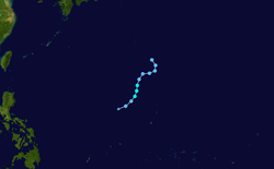
Nancy directly originated from a segment of a tropical upper-tropospheric trough, an atmospheric feature that was farther north than average in mid-August1964.[254][24] Ship observations suggested that the system became a tropical depression August17 and became a tropical storm a day later.[23] Nancy maintained low-end tropical storm intensity at peak strength before being downgraded to a tropical depression the next day approximately 480km (300mi) northeast of Iowa Jima, after which it dissipated.[253][23]
Olga remained within the Gulf of Tonkin for the entirety of its existence, taking a southward trajectory. The CMA determined that the cyclone formed on August21, and became a tropical storm by August24. The JTWC assessed that Olga lasted more briefly, beginning as a tropical depression on August23 and peaking as a tropical storm the next day with one-minute sustained winds of 85km/h (53mph). It maintained this intensity and remained quasi-stationary over the gulf. Olga weakened to a tropical depression on August25 and degenerated into a non-circulating cluster of thunderstorms later that day.[255][7][23]
Tropical Storm Pamela was first detected on imagery from the TIROS weather satellites on August25. At the time, it was located southeast of Wake Island.[23][12] It began as a tropical depression and became a tropical storm at 06:00UTC on August25, with its maximum winds increasing until reaching 95km/h (59mph). Pamela moved towards the west-northwest and subsequently weakened; on August26, the system weakened to a tropical depression and dissipated after a center of circulation could not be identified by aircraft reconnaissance.[23][256]
The CMA determined that Violet formed in the South China Sea on September12, while the JTWC assessed tropical cyclogenesis on the following day.[257][13]:77 The system quickly strengthened and reached tropical storm and later typhoon intensity on September14. Violet's one-minute sustained winds topped out at 140km/h (87mph) just prior to moving ashore Vietnam.[13]:77 Violet made landfall on Vietnam on the morning of September15.[164]:76 It weakened quickly over land with the JTWC issuing its last advisory on the system on September15 and the CMA considering the system to have dissipated on September16.[257][13]:77
The storm generated rainfall totals in excess of 190mm (7.5in) between September14–17,[164]:76 punctuated by a maximum measured value of 245mm (9.6in).[164]:145 Ninety percent of homes were destroyed in Quảng Bình Province according to early reports.[13]:77 U.S. Marine Corps helicopters were deployed to evacuate those affected by the storm in Tam Kỳ, Vietnam. Light damage was wrought to facilities associated with U.S. Marine Corps support operations in Vietnam.[166]:159
Between the 15th and 18th, a low-pressure area monitored by the Philippines developed into tropical storm Oring and then weakened on the 17th, being monitored by the JMA and HKO at the 17th.
Depressions
On the January 26th, the system developed into a tropical depression in the Caroline region.
Between the 15th and 19th of May, a tropical depression was recognized as 02W.
Between July 1st and 2nd, a tropical depression developed and was designated as 06W.
Between July 19th and 23rd, a tropical depression named Maring developed in the Philippines and was upgraded to 11W.
Around August 3rd, a low-pressure system formed in the Philippines within the South China Sea developed into tropical depression Reming.
Between August 24th and 26th, a tropical depression was classified as 23W.
In Caroline Island from September 7th to 9th, a tropical depression was detected, classified as 28W.
On September 15th, the tropical depression was classified as 31W.
Between October 20th and 24th, a low pressure system was recorded at 40W.
Between October 30th and November 4th, another tropical depression system was recorded as 42W.
Between November 19th and 20th, a tropical depression was recorded as 47W.
Between December 5th and 9th, a tropical depression was recorded as 50W.
Off the coast of Caroline Islands, tropical depression system 52W was recorded between December 10th and 19th.
A notable tropical depression system 53W was last recorded in the southern Philippines region on December 28-29.
During the season, 39 named tropical cyclones developed in the Western Pacific and were named by the Joint Typhoon Warning Center. The names were drawn sequentially from a set of four alphabetical naming lists and were all feminine.[258][259][260]
After the season, the JTWC announced that the name Tilda would be removed from the list, possibly due to it sounding similar to Wilda and causes massive floods to river Mekong Delta. It was replaced with Therese, which was first used in the 1967 season.[citation needed]
The Philippine Weather Bureau (later reorganized in December 1972 as PAGASA or the Philippine Atmospheric, Geophysical and Astronomical Services Administration) uses its own naming scheme for tropical cyclones in their area of responsibility. The agency assigns names to tropical depressions that form within their area of responsibility and any tropical cyclone that might move into their area of responsibility. PWB/PAGASA uses its own naming scheme that starts in the Filipino alphabet, with names of Filipino female names ending with "ng" (A, B, K, D, etc.). Should the list of names for a given year prove to be insufficient, names are taken from an auxiliary list, the first 6 of which are published each year before the season starts (in this case, all of them are used up and more auxiliary names are given). All of the storm names here are used for the first time (and only, in case of Dading). The names not retired from this list will be used again in the 1968 season.
After the season, the weather bureau announced that the name Dading would be struck from their naming lists due to its impacts and was replaced by Didang which was first used during the 1968 season; this name was later retired by the agency after the 1976 Pacific typhoon season and replaced with Ditang, which was first used during the 1980 season.
Season effects
This table will list all the storms that developed in the northwestern Pacific Ocean west of the International Date Line and north of the equator during 1964. It will include their intensity, duration, name, areas affected, deaths, missing persons (in parentheses), and damage totals. Classification and intensity values will be based on estimations conducted by the JMA. All damage figures will be in 1964USD. Damages and deaths from a storm will include when the storm was a precursor wave or an extratropical low.
In the South China Sea region, around longitude 120°E, 34 low-pressure systems were recorded, including 21 typhoons (2 unofficial), marking a record storm season in this area.
South-West Indian Ocean cyclone seasons: 1963–64, 1964–65
Notes
123456789101112131415161718192021222324252627282930313233343536373839The Joint Typhoon Warning Center (JTWC) estimates the maximum sustained wind of a tropical cyclone has the highest windspeed averaged over one minute, the China Meteorological Administration (CMA) averages such winds over two minutes, and the Hong Kong Observatory (HKO) and Japan Meteorological Agency (JMA) averages such winds over ten minutes in their historical records.[5]
↑"Hong Kong In Path of Typhoon Sally". The Arizona Republic. Phoenix, Arizona. United Press International. September 10, 1964. p.2. Retrieved July 3, 2020– via Newspapers.com.
12"Smooth Log, North Pacific Weather: May and June 1964". Mariners Weather Log. 8 (6). Silver Spring, Maryland: National Oceanic and Atmospheric Administration: 205–211. November 1964.
↑"Rough Log, North Pacific Weather: June and July 1971". Mariners Weather Log. 15 (5). Silver Spring, Maryland: National Oceanic and Atmospheric Administration: 327. September 1971.
123456789"Smooth Log, North Pacific Weather: July and August 1964". Mariners Weather Log. 9 (1). Silver Spring, Maryland: National Oceanic and Atmospheric Administration: 18–20. January 1965.
123Atkinson, Gary D. (April 1, 1971). "Tropical Synoptic Models". Forecasters' Guide to Tropical Meteorology. Air Weather Service. pp.7–25. Retrieved June 26, 2020– via Google Books.
↑Lander, Mark; Holland, Greg J. (October 1993). "On the interaction of tropical-cyclone-scale vortices. I: Observations". Quarterly Journal of the Royal Meteorological Society. 119 (514): 1347–1361. Bibcode:1993QJRMS.119.1347L. doi:10.1002/qj.49711951406.
1234567"1964 Typhoon TESS (1964133N10134)". IBTrACS – International Best Track Archive for Climate Stewardship. Asheville, North Carolina: University of North Carolina–Asheville. 2018. Retrieved June 12, 2020.
1234Weir, Robert C. (October 25, 1983). Tropical Cyclones Affecting Guam (1671–1980)(PDF) (Report). San Francisco, California: Joint Typhoon Warning Center. Archived(PDF) from the original on July 5, 2020. Retrieved June 12, 2020.
↑"Texas Man Believed Drowned in Typhon". Shreveport Journal. Vol.70. Shreveport, Louisiana. Associated Press. May 23, 1964. p.1. Retrieved June 12, 2020– via Newspapers.com.
↑"Typhoon Misses Marcus Island". Daily Press. Vol.59, no.134. Newport News, Virginia. Associated Press. May 22, 1964. p.46. Retrieved June 12, 2020– via Newspapers.com.
↑"Typhoon Hits Marcus Isle; Yank Missing". Chicago Tribune. Vol.117, no.144. Chicago, Illinois. Associated Press. May 23, 2020. pp.2–9. Retrieved June 12, 2020– via Newspapers.com.
12345"1964 Typhoon VIOLA (1964143N13112)". IBTrACS – International Best Track Archive for Climate Stewardship. Asheville, North Carolina: University of North Carolina–Asheville. 2018. Retrieved June 12, 2020.
↑Chu, C. Y. (2004). "Wong Tai Sin, Kowloon Tsai, and Social Services in the 1960s". The Maryknoll Sisters in Hong Kong, 1921-1969 (1sted.). New York, New york: Palgrave Macmillan. pp.109–127. doi:10.1057/9781403981615_6. ISBN978-1-4039-8161-5.
↑Wright, A. M. J. (1964). "Annual Departmental Reports 1964-65". Hong Kong, China: Hong Kong Public Works Department. Retrieved June 12, 2020– via Google Books.
↑"Viola Gave Hong Kong More Baths". The Miami Herald. No.182. Miami, Florida. May 31, 1964. p.20-A. Retrieved June 13, 2020– via Newspapers.com.
↑"Typhoon Damage in Hong Kong". St. Joseph News-Press. Vol.92, no.129. St. Joseph, Missouri. Associated Press. May 28, 1964. p.12B. Retrieved June 13, 2020– via Newspapers.com.
12"Typhoon Damages". Great Falls Tribune. Vol.79, no.17. Great Falls, Montana. United Press International. May 30, 1964. p.1. Retrieved June 13, 2020– via Newspapers.com.
12"Typhoon Leaves 41 Injured in Hong Kong". Chicago Tribune. No.151. Chicago, Illinois. United Press International. May 30, 1964. p.8. Retrieved June 13, 2020– via Newspapers.com.
↑"Typhoon Viola Hits Hong Kong". The Canberra Times. Vol.38, no.10860. Canberra, Australia. Australian Associated Press. May 29, 1964. p.11. Retrieved June 12, 2020– via Trove.
12345"1964 Typhoon WINNIE (1964177N09142)". IBTrACS – International Best Track Archive for Climate Stewardship. Asheville, North Carolina: University of North Carolina–Asheville. 2018. Retrieved June 13, 2020.
↑"Typhoon toll hits 107". Wilmington Morning News. Vol.166, no.3. Wilmington, Delaware. United Press International. July 3, 1964. p.3. Retrieved June 13, 2020– via Newspapers.com.
↑"Typhoon Winnie's Deaths Reach 120". Fort Lauderdale News and Sun-Sentinel. Fort Lauderdale, Florida. United Press International. July 5, 1964. p.10B. Retrieved June 13, 2020.
1234"Philippine Area Ruined By Typhoon". Port Huron Times Herald. Vol.53, no.183. Port Huron, Michigan. Associated Press. June 13, 2020. p.8. Retrieved June 13, 2020– via Newspapers.com.
12"Typhoon Sweeps Manila, Causing 16 Deaths". Statesville Record & Landmark. Vol.90, no.156. Statesville, North Carolina. United Press International. June 30, 1964. p.1. Retrieved June 13, 2020– via Newspapers.com.
↑"Homes Fall As Typhoon Hits Manila". Fort Worth Star-Telegram. No.151. Fort Worth, Texas. Associated Press. June 30, 1964. p.5. Retrieved June 13, 2020– via Newspapers.com.
↑Storm Surge Occurrences in the Philippines (1897–1998), Quezon City, Philippines: Philippine Atmospheric, Geophysical and Astronomical Services Administration, February 29, 2000
↑"Typhoon Batters Philippines; 16 Die". The Oakland Tribune. Vol.178, no.182. Oakland, California. June 30, 1964. p.E15. Retrieved June 13, 2020– via Newspapers.com.
↑"Viet Nam To Help Typhoon Victims". Daily Press. Vol.69, no.184. Newport News, Virginia. Associated Press. July 11, 1964. p.16. Retrieved June 13, 2020– via Newspapers.com.
↑Kleinen, John (February 2007). "Historical perspectives on typhoons and tropical storms in the natural and socio-economic system of Nam Dinh (Vietnam)". Journal of Asian Earth Sciences. 29 (4). Elsevier: 523–531. Bibcode:2007JAESc..29..523K. doi:10.1016/j.jseaes.2006.05.012.
12345"1964 Typhoon ALICE (1964178N12149)". IBTrACS – International Best Track Archive for Climate Stewardship. Asheville, North Carolina: University of North Carolina–Asheville. 2018. Retrieved June 13, 2020.
123456"1964 Typhoon BETTY (1964184N22133)". IBTrACS – International Best Track Archive for Climate Stewardship. Asheville, North Carolina: University of North Carolina–Asheville. 2018. Retrieved June 12, 2020.
↑"過去の主な台風の記録". 宮古島地方気象台 (in Japanese). Tokyo, Japan: Japan Meteorological Agency. Archived from the original on July 17, 2020. Retrieved June 13, 2020.
1234"1964 Super Typhoon CORA (1964187N07150)". IBTrACS – International Best Track Archive for Climate Stewardship. Asheville, North Carolina: University of North Carolina–Asheville. 2018. Retrieved June 13, 2020.
↑"Typhoon Cora Weakens, Says Weather Bureau". Honolulu Star-Bulletin. Vol.53, no.191. Honolulu, Hawaii. United Press International. July 9, 1964. p.15. Retrieved June 13, 2020– via Newspapers.com.
↑"'Cora' Bears Down on PI". Guam Daily News. Vol.19, no.166. Hagåtña, Guam. Associated Press. July 11, 1964. p.16. Retrieved June 13, 2020– via Newspapers.com.
↑"Typhoon In Philippines". The Honolulu Advertiser. No.54454. Honolulu, Hawaii. United Press International. July 13, 1964. p.A2. Retrieved June 13, 2020– via Newspapers.com.
↑"Typhoon Nears P.I."The Honolulu Advertiser. No.54455. Honolulu, Hawaii. United Press International. July 14, 1964. p.A2. Retrieved June 13, 2020– via Newspapers.com.
1234"1964 Typhoon DORIS (1964193N10145)". IBTrACS – International Best Track Archive for Climate Stewardship. Asheville, North Carolina: University of North Carolina–Asheville. 2018. Retrieved June 14, 2020.
12345"1964 Typhoon ELSIE (1964196N17144)". IBTrACS – International Best Track Archive for Climate Stewardship. Asheville, North Carolina: University of North Carolina–Asheville. 2018. Retrieved June 22, 2020.
↑"Typhoon Threat". Guam Daily News. Vol.19, no.172. Hagåtña, Guam. Associated Press. July 18, 1964. p.13. Retrieved June 14, 2020– via Newspapers.com.
↑"Typhoon Elsie Nears Formosa". Star-Bulletin & Advertiser. No.54460. Honolulu, Hawaii. United Press International. July 19, 1964. p.A-2. Retrieved June 14, 2020– via Newspapers.com.
↑"Typhoon Moves Toward Luzon". Star Bulletin & Advertiser. No.54460. Honolulu, Hawaii. United Press International. July 19, 1964. p.A-6. Retrieved June 14, 2020– via Newspapers.com.
1234"1964 Typhoon FLOSSIE (1964206N18128)". IBTrACS – International Best Track Archive for Climate Stewardship. Asheville, North Carolina: University of North Carolina–Asheville. 2018. Retrieved June 23, 2020.
↑"Typhoon Buffets 3 Naval Vessels". Springfield Leader-Press. Vol.32, no.63. Springfield, Missouri. Associated Press. July 27, 1964. p.6. Retrieved June 22, 2020– via Newspapers.com.
↑"Navy Tug Refloated At Okinawa". Hawaii Tribune-Herald. Vol.42, no.207. Hilo, Hawaii. July 28, 1964. p.1. Retrieved June 22, 2020– via Newspapers.com.
↑"2 Navy Ships Collide In Wind Of Typhoon". The Sacramento Bee. Vol.214, no.34887. Sacramento, California. Associated Press. July 27, 1964. p.7. Retrieved June 22, 2020– via Newspapers.com.
↑"Stuck After A Rescue". The Kansas City Times. Vol.127, no.181. Kansas City, Missouri. Associated Press. July 28, 1964. p.2. Retrieved June 22, 2020– via Newspapers.com.
↑"Typhoon Fringe Hits Korea". The Evening Sun. Vol.109, no.88. Baltimore, Maryland. Associated Press. July 30, 1964. p.A4. Retrieved June 22, 2020– via Newspapers.com.
↑"Fearful 'Flossie' Leaves 17 Dead". The Windsor Star. Vol.92, no.129. Windsor, Ontario. United Press International. August 1, 1964. p.29. Retrieved June 23, 2020– via Newspapers.com.
↑"Korean Typhoon Death Toll 17". The Odessa American. Vol.39, no.185. Odessa, Texas. United Press International. July 31, 1964. p.3. Retrieved June 22, 2020– via Newspapers.com.
123"1964 Severe Tropical Storm GRACE (1964208N17142)". IBTrACS – International Best Track Archive for Climate Stewardship. Asheville, North Carolina: University of North Carolina–Asheville. 2018. Retrieved June 23, 2020.
123456"1964 Super Typhoon HELEN (1964209N17150)". IBTrACS – International Best Track Archive for Climate Stewardship. Asheville, North Carolina: University of North Carolina–Asheville. 2018. Retrieved June 24, 2020.
↑Park, Won-kyu, ed. (1997). Proceedings of the East Asia Workshop on Tree-Ring Analysis. Agricultural Science & Technology Institute of Chungbuk National University.
↑"Typhoon Hits Japanese Island". The Index-Journal. No.183. Greenwood, South Carolina. Associated Press. August 1, 1964. p.1. Retrieved June 23, 2020– via Newspapers.com.
↑"Typhoon Hits Japan: Damages City". The Sydney Morning Herald. No.39508. Sydney, Australia. Australian Associated Press, Reuters. August 3, 1964. p.4. Retrieved June 23, 2020– via Newspapers.com.
12"Typhoon Helen Batters Japan". Fort Myers News-Press. Fort Myers, Florida. Associated Press. August 2, 1964. p.3-A. Retrieved June 23, 2020– via Newspapers.com.
↑"1 Dead, 16 Hurt As Typhoon Hits Southern Japan". The Palladium-Item. Vol.134, no.184. Richmond, Indiana. United Press International. August 2, 1964. p.19. Retrieved June 23, 2020– via Newspapers.com.
↑"Typhoon-Kicked Seas Claim 13". Daily News. New York, New York. Associated Press. August 3, 1964. p.30. Retrieved June 23, 2020– via Newspapers.com.
↑"Korea Typhoon Kills 9". Evening Journal. Vol.32, no.182. Wilmington, Delaware. United Press International. August 3, 1964. p.14. Retrieved June 24, 2020– via Newspapers.com.
↑"Typhoon Sinks Boat". The Sun. Vol.78, no.255. Vancouver, Canada. United Press International. August 4, 1964. p.1. Retrieved June 24, 2020– via Newspapers.com.
123"1964 Super Typhoon IDA (1964215N07150)". IBTrACS – International Best Track Archive for Climate Stewardship. Asheville, North Carolina: University of North Carolina–Asheville. 2018. Retrieved June 24, 2020.
12"Typhoon Kills 4 in Hong Kong". The Sun. Vol.255, no.73. Baltimore, Maryland. Associated Press. August 10, 1964. p.2. Retrieved June 24, 2020– via Newspapers.com.
↑"Typhoon Toll Rises". The Berkshire Eagle. Vol.73, no.78. Pittsfield, Massachusetts. United Press International. August 10, 1964. p.3. Retrieved June 24, 2020– via Newspapers.com.
↑"Report Typhoon Ida Headed For Tonkin Gulf". The Vidette-Messenger. Vol.38, no.30. Valparaiso, Indiana. United Press International. August 8, 1964. p.11. Retrieved June 24, 2020– via Newspapers.com.
123"Typhoon 'Ida' Dumps Rains". Spokane Daily Chronicle. Spokane, Washington. United Press International. 7 August 1964. p.2. Retrieved March 11, 2020– via Newspapers.com.
↑"Typhoon Rips Philippines". Kingsport Times. Vol.49, no.159. Kingsport, Tennessee. United Press International. August 7, 1964. p.10. Retrieved June 24, 2020– via Newspapers.com.
↑"Typhoon Ida Rips China Mainland". The Cincinnati Enquirer. No.123. Cincinnati, Ohio. United Press International. August 10, 1964. p.12. Retrieved June 24, 2020– via Newspapers.com.
↑"Typhoon Ida Heads Towards Chinese Coast". Poughkeepsie Journal. Poughkeepsie, New York. Associated Press. 7 August 1964. p.5. Retrieved 11 March 2020– via Newspapers.com.
↑"Tropical Cyclones in 2008". Hong Kong, China: Hong Kong Observatory. November 27, 2019. Retrieved June 24, 2020.
↑"Typhoon Ida Heads for China Coast". Daily Journal Gazette. No.172. Mattoon, Illinois. Associated Press. August 8, 1964. p.3. Retrieved June 24, 2020– via Newspapers.com.
↑"Meeting of 2nd September 1964"(PDF). Official Report of Proceedings. Hong Kong, China: Search Results Web Result with Site Links Legislative Council of Hong Kong. September 2, 1964. p.305. Retrieved June 24, 2020.
12345"1964 Tropical Storm JUNE (1964222N10144)". IBTrACS – International Best Track Archive for Climate Stewardship. Asheville, North Carolina: University of North Carolina–Asheville. 2018. Retrieved June 25, 2020.
↑"Typhoon Developing". Des Moines Register. Des Moines, Iowa. Associated Press. August 12, 1964. p.9. Retrieved June 25, 2020– via Newspapers.com.
1234567"1964 Super Typhoon KATHY (1964224N25161)". IBTrACS – International Best Track Archive for Climate Stewardship. Asheville, North Carolina: University of North Carolina–Asheville. 2018. Retrieved June 25, 2020.
↑"Typhoon By-Passes Tokyo". The Indianapolis News. Indianapolis, Indiana. United Press International. August 15, 1964. p.1. Retrieved June 25, 2020– via Newspapers.com.
↑"Japan Area Has Strong Winds". Hawaii Tribune-Herald. Vol.42, no.226. Hilo, Hawaii. Associated Press. August 16, 1964. p.1. Retrieved June 25, 2020– via Newspapers.com.
↑"Typhoon Hits Japan". The Brandon Sun. No.183. Brandon, Manitoba. Associated Press. August 24, 1964. p.1. Retrieved June 26, 2020– via Newspapers.com.
↑"Typhoon Hits Jap Island". The Desert Sun. Vol.38, no.17. Palm Springs, California. United Press International. August 24, 1964. p.2. Retrieved June 26, 2020– via Newspapers.com.
12"Killer Typhoon Rakes Three Japan Islands". Honolulu Advertiser. No.54497. Honolulu, Hawaii. United Press International. August 25, 1964. p.7. Retrieved June 26, 2020– via Newspapers.com.
12"Typhoon Now Tropical Storm". The Tampa Times. No.172. Tampa, Florida. Associated Press. August 25, 1964. p.6. Retrieved June 26, 2020– via Newspapers.com.
↑"Typhoon Kathy Hits Isle South of Japan". The Sacramento Bee. Vol.215, no.34913. Sacramento, California. Associated Press. August 22, 1964. p.1. Retrieved June 25, 2020– via Newspapers.com.
↑"95 m.p.h. Typhoon Races on Kysuhu". Oakland Tribune. Vol.178, no.236. Oakland, California. United Press International. August 23, 1964. p.5. Retrieved June 26, 2020– via Newspapers.com.
↑Proceedings of the Japan National Committee for Theoretical and Applied Mechanics, Volumes 17–18. Japan National Committee for Theoretical and Applied Mechanics. 1973. p.79.
↑"Typhoon Heading for Tokyo". The Sydney Morning Herald. No.39527. Sydney, Australia. August 25, 1964. p.3. Retrieved June 26, 2020– via Newspapers.com.
↑"Typhoon Rips Japan; 28 Dead in Wake". The Muncie Star. Vol.88, no.119. Muncie, Indiana. United Press International. August 25, 1964. p.5. Retrieved June 26, 2020– via Newspapers.com.
↑"Typhoon Floods Thirsty Japan". The Daily Oklahoman. Vol.73, no.234. Oklahoma City, Oklahoma. Reuters. August 26, 1964. p.2. Retrieved June 26, 2020– via Newspapers.com.
123"1964 Tropical Storm LORNA (1964225N16139)". IBTrACS – International Best Track Archive for Climate Stewardship. Asheville, North Carolina: University of North Carolina–Asheville. 2018. Retrieved June 26, 2020.
1234"1964 Typhoon MARIE (1964225N18128)". IBTrACS – International Best Track Archive for Climate Stewardship. Asheville, North Carolina: University of North Carolina–Asheville. 2018. Retrieved June 26, 2020.
123"1964 Super Typhoon RUBY (1964245N20132)". IBTrACS – International Best Track Archive for Climate Stewardship. Asheville, North Carolina: University of North Carolina–Asheville. 2018. Retrieved June 28, 2020.
↑"15 Killed In Typhoon". Southern Illinoisan. Vol.72, no.213. Carbondale, Illinois. September 6, 1964. p.1. Retrieved July 3, 2020– via Newspapers.com.
12"Hong Kong Lashed by Vicious Typhoon". Honolulu Star-Bulletin. Vol.53, no.249. Honolulu, Hawaii. September 5, 1964. pp.1–2. Retrieved June 29, 2020– via Newspapers.com.
↑"Typhoon Toll Of Missing, Dead Hits 43". The Shreveport Times. Vol.93, no.285. Shreveport, Louisiana. United Press International. July 3, 2020. p.1. Retrieved July 3, 2020– via Newspapers.com.
↑"Reports Say Ruby Killed 700 In China". Fort Lauderdale News. Fort Lauderdale, Florida. Associated Press. September 18, 1964. p.1. Retrieved July 3, 2020– via Newspapers.com.
12345"1964 Super Typhoon SALLY (1964247N09159)". IBTrACS – International Best Track Archive for Climate Stewardship. Asheville, North Carolina: University of North Carolina–Asheville. 2018. Retrieved June 28, 2020.
12"Typhoon Blows By Philippines". Santa Maria Times. Santa Maria, California. United Press International. September 9, 1964. p.23. Retrieved July 3, 2020– via Newspapers.com.
↑"Over $115-Gs Damage By 'Sally' Here". Guam Daily News. Vol.19, no.224. Hagåtña, Guam. September 15, 1964. p.12. Retrieved July 3, 2020– via Newspapers.com.
↑"Typhoon Sally Damages 18 Houses Here". Guam Daily News. Vol.19, no.217. Hagåtña, Guam. September 7, 1964. p.1. Retrieved July 3, 2020– via Newspapers.com.
↑"Typhoon Sally Does Light Damage". The Sacramento Bee. Vol.215, no.34928. Sacramento, California. September 6, 1964. p.A16. Retrieved July 3, 2020– via Newspapers.com.
↑"Huge Typhoon Heads For Hong Kong". Los Angeles Times. Vol.83. Los Angeles, California. United Press International. September 10, 1964. p.23. Retrieved July 3, 2020– via Newspapers.com.
↑"Sally Smashes Into Hong Kong". The Windsor Star. Vol.93, no.8. Windsor, Ontario. United Press International. September 10, 1964. p.1. Retrieved July 3, 2020– via Newspapers.com.
↑"Huge Typhoon Sets Hong Kong Chinese Panic". Corsicana Daily Sun. Vol.69, no.81. Corsicana, Texas. Associated Press. September 10, 1964. pp.1, 7. Retrieved July 3, 2020– via Newspapers.com.
↑"Hong Kong Buttons Up". The Miami Herald. No.281. Miami, Florida. Associated Press. September 10, 1964. p.2A. Retrieved July 3, 2020– via Newspapers.com.
12Shing, Pun Kwok (May 1966). A Survey of the Climatological Phenomena of Typhoons of Western N. Pacific Ocean and the South China Sea With Special Preference to Hong Kong (M.A.). University of Hong Kong.
↑Essoyan, Roy (September 11, 1964). "Typhoon Sally Hits Hong Kong". The Oregon Statesman. No.168. Salem, Oregon. Associated Press. p.26. Retrieved July 4, 2020– via Newspapers.com.
↑"Korea Flood Toll Grows". Evening Journal. Vol.32, no.217. Wilmington, Delaware. Associated Press. September 14, 1964. p.2. Retrieved July 4, 2020– via Newspapers.com.
↑"Korea Storm Toll May Reach 400". Independent. Vol.27, no.16. Long Beach, California. Associated Press. September 16, 1964. p.A5. Retrieved July 4, 2020– via Newspapers.com.
↑"Storm Kills 190". The News and Observer. Vol.199, no.77. Raleigh, North Carolina. United Press International. September 15, 1964. p.2. Retrieved July 4, 2020– via Newspapers.com.
123"1964 Typhoon TILDA (1964256N17141)". IBTrACS – International Best Track Archive for Climate Stewardship. Asheville, North Carolina: University of North Carolina–Asheville. 2018. Retrieved September 4, 2020.
↑"Hong Kong Braces for Typhoon Tilda". Wilkes-Barre Record. Wilkes-Barre, Pennsylvania. Associated Press. September 15, 1964. Retrieved July 15, 2020– via Newspapers.com.
12The Year's Weather(PDF). Hong Kong, China: The Chinese University of Hong Kong. 1964. Retrieved November 11, 2020.
↑Nhuan, Mai Trong; Hien, Le Thi Thu; Ha, Nguyen Thi Hoang; Hue, Nguyen Thi Hong; Quy, Tran Dang (July 2014). "An integrated and quantitative vulnerability assessment for proactive hazard response and sustainability: a case study on the Chan May-Lang Co Gulf area, Central Vietnam". Sustainability Science. 9 (3). Springer: 399–409. doi:10.1007/s11625-013-0221-9. S2CID154483075– via SpringerLink.
↑"3 Missing in Floods". Fort Worth Star-Telegram. Fort Worth, Texas. Reuters. September 25, 1964. p.13. Retrieved September 4, 2020– via Newspapers.com.
↑"Thailand Flood". Wilkes-Barre Times Leader, the Evening News. Wilkes-Barre, Pennsylvania. Associated Press. September 26, 1964. p.12. Retrieved September 4, 2020– via Newspapers.com.
1234567"1964 Super Typhoon WILDA (1964261N12149)". IBTrACS – International Best Track Archive for Climate Stewardship. Asheville, North Carolina: University of North Carolina–Asheville. 2018. Retrieved November 9, 2020.
↑"Typhoon Wilda Sweeps Japan". Salinas Californian. No.232. Salinas, California. United Press International. September 25, 1964. p.5. Retrieved November 9, 2020– via Newspapers.com.
12Yamamoto, Ryozaburo; Mitsuta, Yasuhi; Miyata, Kenji; Tahira, Makoto (March 1965). "Surface Winds of Typhoon Wilda (6420) Over Japan". Disaster Prevention Research Institute Annuals (in Japanese). 8. Kyoto, Japan: Disaster Prevention Research Institute: 593–604. hdl:2433/69194. Retrieved November 9, 2020– via Kyoto University Research Information Repository.
↑"Heavy Toll in Japan From Typhoon Wilda". Waterloo Daily Courier. Waterloo, Iowa: Associated Press. September 25, 1964. p.21. Retrieved November 9, 2020– via Newspapers.com.
↑"Year's Worst Typhoon Lashes Japan Islands". The Honolulu Advertiser. No.54527. Honolulu, Hawaii. United Press International. September 24, 1964. Retrieved September 26, 2020– via Newspapers.com.
↑"Typhoon Ruins Ship; Crew Of 41 Is Safe". The Sacramento Bee. Vol.215, no.34948. Sacramento, California. Associated Press. September 26, 1964. p.A4. Retrieved November 9, 2020– via Newspapers.com.
↑"Typhoon Wilda Brings Death To Kyushu Island". Great Bend Daily Tribune. No.38. Great Bend, Kansas. United Press International. September 24, 1964. p.2. Retrieved September 26, 2020– via Newspapers.com.
↑強風災害の発生と被害に関する統計(PDF) (Report) (in Japanese). General Insurance Rating Organization of Japan. Retrieved November 9, 2020.
↑"Typhoon Tosses Freighter About". Fort Myers News-press. Associated Press. September 25, 1964. p.1. Retrieved November 9, 2020– via Newspapers.com.
↑"Storm Capsizes Transport". The La Crosse Tribune. Vol.60, no.130. La Crosse, Wisconsin. United Press International. September 25, 1964. Retrieved November 9, 2020– via Newspapers.com.
↑Rodda, John (September 30, 1964). "Japan still has much to do". The Guardian. No.36775. Manchester, United Kingdom. p.6. Retrieved November 9, 2020– via Newspapers.com.
↑"25 Dead As Storm Hits Japan". The Miami Herald. No.299. Miami, Florida. United Press International. September 25, 1964. p.1. Retrieved November 9, 2020– via Newspapers.com.
↑"36 Dead In Wake Of Japan Typhoon". The Honolulu Advertiser. No.54529. Honolulu, Hawaii. United Press International. September 26, 1964. p.A-2. Retrieved November 9, 2020.
12"1964 Severe Tropical Storm ANITA (1964267N17120)". IBTrACS – International Best Track Archive for Climate Stewardship. Asheville, North Carolina: University of North Carolina–Asheville. 2018. Retrieved November 9, 2020.
12"Smooth Log, North Pacific Weather: September and October 1964". Mariners Weather Log. 9 (1). Silver Spring, Maryland: National Oceanic and Atmospheric Administration: 52–59. January 1965.
12"10,000 Families Homeless In Luzon Storm". The Honolulu Advertiser. No.54534. Honolulu, Hawaii. United Press International. October 1, 1964. p.A-8. Retrieved November 10, 2020– via Newspapers.com.
↑"10,000 P.I. Families Flee Tropical Storm". Pacific Stars and Stripes. Vol.20, no.275. Tokyo, Japan. United Press International. October 2, 1964. p.28 – via NewspaperArchive.com.
123"Typhoon Dot". Hong Kong, China: Hong Kong Observatory. November 27, 2019. Retrieved November 11, 2020.
↑"34 Dead, 70 Hurt As Typhoon Dot Batters Hong Kong". The Sydney Morning Herald. No.39570. Sydney, Australia. Australian Associated Press. October 14, 1964. p.3. Retrieved November 12, 2020– via Newspapers.com.
12"Typhoon Dot Toll Hits 22". The Daily Oklahoman. Vol.73, no.283. Oklahoma City, Oklahoma. Reuters. October 14, 1964. p.5. Retrieved November 12, 2020– via Newspapers.com.
↑Woon-Pui, Kwong (April 1974). Tropical Cyclone Rainfall in Hong Kong(PDF) (Report). Hong Kong, China: Hong Kong Observatory. p.58. Retrieved November 11, 2020.
↑"Typhoon Dot Kills 24 in Hong Kong". The Express. Vol.83, no.192. Lock Haven, Pennsylvania. Associated Press. October 14, 1964. p.11. Retrieved November 12, 2020– via Newspapers.com.
↑"Typhoon toll". Port Angeles Evening News. Port Angeles, Washington. Associated Press. October 17, 1964. p.8. Retrieved November 11, 2020– via Newspapers.com.
↑"Typhoon Dot Kills 21 in Hong Kong". The Miami Herald. Miami, Florida. Miami Herald-Los Angeles Times Wire. October 15, 1964. p.1. Retrieved November 11, 2020– via Newspapers.com.
12Joint Typhoon Warning Center (1965). "Typhoon Iris Summary"(PDF). United States Navy. Archived from the original(PDF) on 2011-06-06. Retrieved March 11, 2010.
123456"1964 Super Typhoon LOUISE:MARGE (1964319N08141)". IBTrACS – International Best Track Archive for Climate Stewardship. Asheville, North Carolina: University of North Carolina–Asheville. 2018. Retrieved November 26, 2020.
12"November 1964"(PDF). United States Weather Bureau (FTP). Asheville, North Carolina. 1965. p.115. Retrieved November 26, 2020– via National Centers for Environmental Information.(To view documents see Help:FTP)
↑"A Typhoon Blow". The Kansas City Star. Vol.85, no.61. Kansas City, Missouri. Associated Press. November 17, 1964. p.1. Retrieved November 26, 2020– via Newspapers.com.
↑"Emergency Aid Moving to TT Isles". Guam Daily News. Vol.219, no.280. Hagåtña, Guam. November 21, 1964. p.12. Retrieved December 1, 2020– via Newspapers.com.
↑"Philippines Get Renewed Storm Warning". The Honolulu Advertiser. No.54591. Honolulu, Hawaii. United Press International. November 29, 1964. p.A1-A. Retrieved December 4, 2020– via Newspapers.com.
↑"Typhoon Toll Rises By 19". The Charlotte Observer. No.258. Charlotte, North Carolina. United Press International. November 22, 1964. p.12A. Retrieved December 4, 2020– via Newspapers.com.
↑"Typhoon Louise Damage Studied". Lansing State Journal. Lansing, Michigan. Associated Press. November 23, 2020. p.D-12. Retrieved December 4, 2020– via Newspapers.com.
↑"Philippine Officials Inspect Typhoon Loss". St. Louis Post-Dispatch. Vol.86, no.325. St. Louis, Missouri. Associated Press. November 23, 1964. p.6A. Retrieved December 4, 2020– via Newspapers.com.
↑"Typhoon Leaves Over 100 Dead In Philippines". Wilkes-Barre Time Leader. Wilkes-Barre, Pennsylvania. Associated Press. November 20, 1964. p.1. Retrieved November 29, 2020– via Newspapers.com.
12"Storm Toll May Hit 200 on Island". The Spokesman-Review. No.191. Spokane, Washington. November 21, 1964. p.8. Retrieved December 1, 2020– via Newspapers.com.
↑"Philippine Ship Sinks; Many Lost". Oakland Tribune. Vol.178, no.334. Oakland, California. United Press International. November 29, 1964. p.A2. Retrieved December 4, 2020– via Newspapers.com.
↑"Typhoon Louise kills 567". The Leader-Post. Vol.55, no.275. Regina, Saskatechwan. Canadian Press. November 25, 1964. p.5. Retrieved December 4, 2020– via Newspapers.com.
↑"Calamity Is Proclaimed In Philippine Province". St. Louis Post-Dispatch. Vol.86, no.327. St. Louis, Missouri. United Press International. November 25, 1964. p.11D. Retrieved December 4, 2020– via Newspapers.com.
↑"Peace Corps Trio Heroes in Shipwreck". Tucson Daily Citizen. Vol.92, no.287. Tucson, Arizona. United Press International. November 30, 1964. p.17. Retrieved November 19, 2020– via Newspapers.com.
↑"Light Storms Damage In 2 TT Isles". Guam Daily News. Vol.19, no.294. Hagåtña, Guam. December 15, 1964. p.1. Retrieved November 27, 2020– via Newspapers.com.
↑"Typhoon Heading For Philippines". Sunday Times-Democrat. Davenport, Iowa. United Press International. December 13, 1964. p.1. Retrieved November 27, 2020– via Newspapers.com.
↑"Typhoon Opal's High Winds Head For Philippines". Daily Press. Vol.69, no.340. Newport News, Virginia. United Press International. December 14, 1964. p.2. Retrieved November 27, 2020– via Newspapers.com.
↑"175-M.P.H. Winds Hit Island In Philippines". Los Angeles Times. Vol.84. Los Angeles, California. United Press International. December 14, 1964. p.19. Retrieved November 27, 2020– via Newspapers.com.
↑"Typhoon Limps Out of Luzon". The Miami Herald. No.16. Miami, Florida. United Press International. December 16, 1964. p.2-A. Retrieved November 27, 2020– via Newspapers.com.
↑"Typhoon Batters Luzon". The Age. No.34198. Melbourne, Australia. December 16, 1964. p.4. Retrieved November 27, 2020– via Newspapers.com.
↑"Typhoon Opal Batters Luzon". The Sydney Morning Herald. No.39623. Sydney, Australia. Australian Associated Press. December 15, 1964. p.3. Retrieved November 27, 2020– via Newspapers.com.
12"Opal rakes islands". Wilmington Morning News. Vol.166, no.148. Wilmington, Delaware. United Press International. December 19, 1964. p.3. Retrieved November 27, 2020– via Newspapers.com.
12"Typhoon Opal Rips Luzon Isle". Tucson Daily Citizen. Vol.92, no.299. Tucson, Arizona. United Press International. December 14, 1964. p.37. Retrieved November 27, 2020– via Newspapers.com.
↑"Typhoon Damage Set at Millions". The Philadelphia Inquirer. Philadelphia, Pennsylvania. United Press International. December 15, 1964. p.1. Retrieved November 27, 2020– via Newspapers.com.
↑"Luzon Island Is Swept By Typhoon Opal". Tyler Morning Telegraph. Vol.37, no.32. Tyler, Texas. United Press International. December 15, 1964. p.5. Retrieved November 27, 2020– via Newspapers.com.
↑"Typhoon Opal Cuts Over S. China Sea". Evening Journal. Vol.32, no.295. Wilmington, Delaware. United Press International. December 15, 1964. p.5. Retrieved November 27, 2020– via Newspapers.com.
123"Thousands Homeless After P.I. Homeless". Honolulu Advertiser. Honolulu, Hawaii. United Press International. December 16, 1964. p.A-4. Retrieved November 27, 2020– via Newspapers.com.
↑"Typhoon Opal Rips Into Luzon". Honolulu Advertiser. No.54606. Honolulu, Hawaii. United Press International. December 15, 1964. p.A-5. Retrieved November 27, 2020– via Newspapers.com.
↑"Sea Captain, Wife Swept to Deaths". The Minneapolis Star. Vol.87, no.20. Minneapolis, Minnesota. Associated Press. December 18, 1964. p.2A. Retrieved November 27, 2020– via Newspapers.com.
12"1964 Tropical Storm NANCY (1964230N25156)". IBTrACS - International Best Track Archive for Climate Stewardship. Asheville, North Carolina: University of North Carolina–Asheville. 2018. Retrieved June 26, 2020.
123"1964 Typhoon VIOLET (1964257N13118)". IBTrACS - International Best Track Archive for Climate Stewardship. Asheville, North Carolina: University of North Carolina–Asheville. 2018. Retrieved September 4, 2020.
↑"Designation of Tropical Depressions". National Hurricane Operations Plan. Washington, D.C.: Interdepartmental Committee for Meteorological Services. April 1969. Retrieved June 25, 2020– via Google Books.
↑"Under the Weather: Typhoon Names". The Boston Globe. Vol.170, no.52. Boston, Massachusetts. August 21, 1956. p.47. Retrieved June 25, 2020– via Newspapers.com.
This page is based on this Wikipedia article Text is available under the CC BY-SA 4.0 license; additional terms may apply. Images, videos and audio are available under their respective licenses.