Peleliu

Last updated
Peleliu
Orange beach - panoramio.jpg
Orange beach, Peleliu
Peleliu in Palau.svg
Location of Peleliu in Palau
Coordinates: 7°0′N134°15′E / 7.000°N 134.250°E / 7.000; 134.250
CountryFlag of Palau.svg  Palau
Capital Kloulklubed
Government
   Governor Emais Roberts
Area
  Total13 km2 (5 sq mi)
Population
 (2015 Census)
  Total484
  Density37/km2 (96/sq mi)
  Official languages
Palauan
English
ISO 3166 code PW-228

Peleliu (or Beliliou) is an island in the island nation of Palau. Peleliu, along with two small islands to its northeast, forms one of the sixteen states of Palau. The island is notable as the location of the Battle of Peleliu in World War II.

Contents

History

Beliliou was traditionally divided into five villages. Teliu is located on the southwest coast bordered on the north by Ngerkeiukl on the west coast, Ngesias in the central portion of the island, and Ngerdelolk on the east coast. Ngerchol occupies the northern part of the island on the west side of Bloody Nose Ridge. Most of the surface remains of the traditional villages have been obliterated. However, the locations of the villages and the locations of features within the villages, including odesongel, are known and preserved in the oral tradition. These traditional features are important symbols giving identity to families, clans and regions. [1]

The lagoon and adjacent rock islands are important resource areas, and probably were intensively exploited prehistorically. Important resources include many different species of trees and other plants and many different species of fish and shellfish. On the islands, traditional gardens would have been located in areas where sufficient soil had accumulated in low lying pockets and marshes. [1]

First sighting of Peleliu, Babeldaob, and Koror recorded by Westerners was by the Spanish expedition of Ruy López de Villalobos at the end of January 1543. They were then charted as Los Arrecifes ("The Reefs" in Spanish). [2] In November and December 1710 these three islands were again visited and explored by the Spanish missionary expedition commanded by Sargento Mayor Francisco Padilla on board of the patache Santísima Trinidad. Two years later they were explored in detail by the expedition of Spanish naval officer Bernardo de Egoy. [3] Following its defeat in the Spanish–American War, Spain sold Palau (including Peleliu) to Germany in 1899. Control passed to Japan in 1914.

During World War II, the Battle of Peleliu was a major battle between units of the United States Marine Corps and United States Army against the Imperial Japanese Army in 1944. The battle for the island was particularly brutal because by this time the Japanese military had evolved island defense tactics with strong fortifications in the island's caves and rock formations within the Umurbrogol Mountains (Bloody Nose Ridge), which enabled a defense in depth which maximized casualties on the attacking force. On both sides involved in the fighting there were high losses with more than 2,000 Americans and 10,000 Japanese killed, but, remarkably, there were no casualties among the local civilians because they were evacuated from the fighting to other islands of Palau.

The ruins of many of the military installations of the era, such as the airstrip, are still intact, and shipwrecks from the battle remain visible underwater just off the coast. There are war memorials on the island to both the American and the Japanese dead. Peleliu and Angaur were the only islands in the Palau archipelago to be occupied by the Americans during the war. The capital of Koror remained in Japanese hands to the end of the war.

Peleliu was formally placed under the control of the United States under United Nations auspices in 1947 as part of the Trust Territory of the Pacific Islands. In 1947, two and a half years after Japanese surrender, there were over 30 Japanese still hiding in caves, believing the war was not over. The Americans sent a senior Japanese military official into the caves to convince them to surrender and the last Japanese survivor, Keiji Nagai, died in 2019. [4]

Palau became independent in 1978, and Peleliu was organized as a state within the new republic. In August 2014, Peleliu hosted the "leader's retreat" at the 45th Pacific Islands Forum, featuring representatives from the forum's 15 member states. [5]

Geography

Peleliu World War II Memorial Museum Muzeum peleliu.JPG
Peleliu World War II Memorial Museum

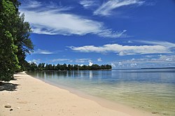
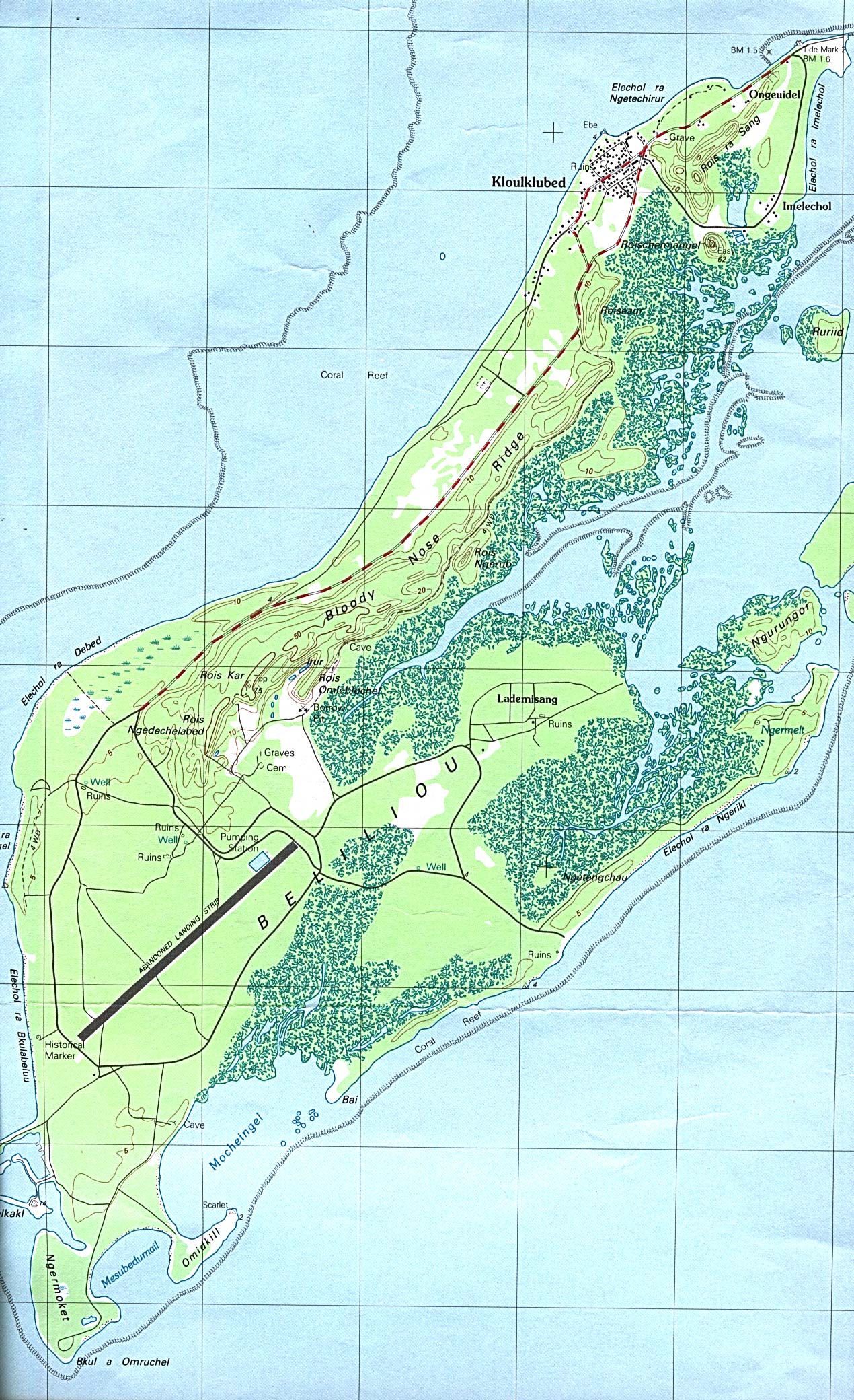
Peleliu is approximately 10 kilometres (5.4 nmi) northeast of the island of Angaur and 40 kilometres (22 nmi) southwest of the island of Koror. The state of Beliliou includes the islands of Beliliou, Ngedbus, Olngeuaol, Ngercheu, Belualasmau, Ruruid, Ngebad, Ngurungor, Ngesuall, and several islets. The total area for the state is approximately 19.52 km2 (7.54 sq mi). Beliliou Island, like Angaur, is a raised platform coralline island with an area of 16.98 km2 (6.56 sq mi). Located at the southern tip of the lagoon which encircles the main group of islands, Beliliou is surrounded by a thick fringe of mangrove forest comprising more than a quarter of its total area. On the island's west side is a steep spine named Bloody Nose Ridge during the Battle for Peleliu in World War II - rising to an elevation of 75 metres (246 ft). A second raised area, Rois ra Sang and Roischemiangel, rises to elevations of just over 50 m at the northern tip of the island. The rest of the island generally lies below 10 metres (33 ft) in elevation. Along this ridge, jagged spires of coralline limestone jut skyward in a tangled maze. [1]

Much of Beliliou is covered by a limestone island forest with stands of Casuarina forest along sandy beach berms. With the exception of Ngercheu, the rest of the islands in the state are low, flat islands with large areas of sandy deposits covered by coconut or Casuarina forests. Ngercheu, located in the northern part of the state, has a typical rock island profile with steep cliffs of uplifted reef covered by a rock island forest. [1]

The geography of Beliliou has been dramatically reshaped by the events of World War II. In preparation for the anticipated American invasion, the Japanese defenders transformed Beliliou into a defensive fortress. The build up, which was underway by 1943, began with the evacuation of Palauans from Beliliou to Babeldaob. As many as 10,000 Japanese defenders dug into the natural caves and fissures of the coralline limestone formations, reinforcing these positions with concrete bunkers. So well established were the Japanese defenders that they withstood a massive naval bombardment and met the American invasion force at nearly full strength on September 5, 1944. The Battle of Peleliu, which proved in hindsight to be a costly miscalculation by the Americans, dragged on for weeks of bitter fighting at a terrible cost of lives. [1]

Most of the land use in Beliliou today is for private gardens located in and around residential areas. There are no commercial enterprises active today, and municipal use is limited to a few small facilities. A large coconut plantation is on Ngedbus Island. [1]

Demography

The population of the state was 484 in the 2015 census and median age was 34.5 years. [6] The official languages of the state are Palauan and English. [7]

As of 2000, its population was about 571, making it the third most populous state of Palau. [8] Most of the island's population lives in the village of Kloulklubed which is the state capital on the northwestern coast. Including the capital, there are a total of four villages:

Today, the major concentration of people live in Kloulklubed near the northern tip of the island. [1]

Islands of the state

The state consists of the following islands:

IslandArea (km2)Population (2000)Coordinates
Peleliu 12.8571 07°00′44.65″N134°15′01.24″E / 7.0124028°N 134.2503444°E / 7.0124028; 134.2503444
Ngercheu 0.930 07°05′33.51″N134°16′41.12″E / 7.0926417°N 134.2780889°E / 7.0926417; 134.2780889
Ngesebus 0.950 07°03′23.92″N134°15′35.94″E / 7.0566444°N 134.2599833°E / 7.0566444; 134.2599833
Ngurungor 0.540 07°01′16.39″N134°16′20.731″E / 7.0212194°N 134.27242528°E / 7.0212194; 134.27242528
Kongauru 0.340 07°03′47.92″N134°16′26.14″E / 7.0633111°N 134.2739278°E / 7.0633111; 134.2739278
Murphy Island 0.020 07°03′54.97″N134°16′56.75″E / 7.0652694°N 134.2824306°E / 7.0652694; 134.2824306

Phosphate

As at Angaur, phosphate mining in the Bloody Nose Ridge area of Beliliou began during the German administration and continued into the Japanese administration. The phosphate was loaded onto ships at a small harbor facility located at the northern tip of the island. [1]

Environment

Both IBAs are important for Micronesian megapodes. Micronesian megapode 6.jpg
Both IBAs are important for Micronesian megapodes.

Important Bird Areas

The island has been designated an Important Bird Area (IBA) by BirdLife International because it supports populations of most of Palau's endemic birds, including Micronesian megapodes, Palau ground doves, Micronesian imperial pigeons, Palau fruit doves, swiftlets, owls and kingfishers, Micronesian myzomelas, morningbirds, Palau fantails, flycatchers and bush warblers, giant, dusky and citrine white-eyes, and Micronesian starlings. [9]

The sandflats, mangroves, seagrass beds and islets just off the northern end of Peleliu provide feeding and roosting habitat for various wader species, as well as being home to megapodes. The site is an IBA for the megapodes, Far Eastern curlews, ruddy turnstones, great knots, red-necked stints, and grey-tailed tattlers. [10]

Political system

The state of Peleliu, with population of less than 500, has an elected chief executive, governor. The state also has a legislature elected every three years. [11] The state population elects one of the members of the House of Delegates of Palau. Obak is the title of the traditional high chief from the state. [12]

Transport

Peleliu Airfield, created by the Japanese in World War II, has the longest and widest runway in Palau (1,850 metres (6,070 ft)), but has been used only by small chartered aircraft after Palau's domestic flights were discontinued in late 2005. A regular boat service connects the island twice a week to Koror and Angaur. Travel time by boat from Koror is over an hour. The small harbor in the far north of the island is shallow and suitable only for yachts with shallow draft.

The main road lies on the west side of Bloody Nose Ridge and extends from Kloulklubed to the landing strip. Secondary roads extend to all parts of the island. The landing strip was built during the Japanese era and originally consisted of a 6600-foot runway oriented SW to NE with a smaller perpendicular runway intersecting the main run way about 2200 feet from the SW. Additional taxiways connected the runways to airport facilities located to the north of the runways. The landing strips are unimproved, but still serve for the daily flight from the Airai airport by a single engine plane. A third landing strip was built on Ngedbus Island, just north of Beliliou, during the Japanese administration. It was abandoned after the Battle of Peleliu and today is overgrown with a coconut plantation. [1]

Peleliu Battlefield

Peleliu Battlefield
LocationPeleliu, Palau
Area7,680 acres (3,110 ha)
Built1944
NRHP reference No. 85001754 [13]
Added to NRHPFebruary 4, 1985

The entire island has been listed on the National Register of Historic Places as the Peleliu Battlefield, and has been designated a U.S. National Historic Landmark. [14]

Education

The Ministry of Education operates public schools.

A church in the state of Peleliu peririyuDao Jiao Hui .jpg
A church in the state of Peleliu

Peleliu Elementary School opened in 1946, and had its second building open in 1966, with the first still in use. [15]

Palau High School in Koror is the country's only public high school, so children from this community go there. [16]

Related Research Articles

<span class="mw-page-title-main">Battle of Peleliu</span> World War II battle in the Pacific theater

The Battle of Peleliu, codenamed Operation Stalemate II by the US military, was fought between the United States and Japan during the Mariana and Palau Islands campaign of World War II, from 15 September to 27 November 1944, on the island of Peleliu.

<span class="mw-page-title-main">Palau</span> Country in the western Pacific

Palau, officially the Republic of Palau, is an island country in the Micronesia subregion of Oceania in the western Pacific. The republic consists of approximately 340 islands and connects the western chain of the Caroline Islands with parts of the Federated States of Micronesia. It has a total area of 466 square kilometers (180 sq mi), making it one of the smallest countries in the world. The most populous island is Koror, home to the country's most populous city of the same name. The capital Ngerulmud is located on the largest island of Babeldaob, in Melekeok State. Palau shares maritime boundaries with international waters to the north, the Federated States of Micronesia to the east, Indonesia to the south, and the Philippines to the northwest.

<span class="mw-page-title-main">History of Palau</span> Historical account of the island country Palau

Palau was initially settled around 1000 BC.

<span class="mw-page-title-main">Geography of Palau</span>

The Republic of Palau consists of eight principal islands and more than 250 smaller ones lying roughly 500 miles southeast of the Philippines, in Oceania. The islands of Palau constitute the westernmost part of the Caroline Islands chain. The country includes the World War II battleground of Peleliu and world-famous rock islands. The total land area is 459 km2 (177 sq mi). It has the 42nd largest Exclusive Economic Zone of 603,978 km2 (233,197 sq mi).

<span class="mw-page-title-main">Koror</span> State in Palau

Koror is the state comprising the main commercial centre of the Republic of Palau. It consists of several islands, the most prominent being Koror Island. It is Palau’s most populous state.

<span class="mw-page-title-main">Angaur</span> State in Palau

Angaur, or Ngeaur in Palauan, is an island and state in the island nation of Palau.

<span class="mw-page-title-main">Babeldaob</span> Largest island of Palau

Babeldaob is the largest island in the island nation of the Republic of Palau. It is in the western Caroline Islands, and the second largest island in the Micronesia region of Oceania. Palau's capital, Ngerulmud, is located on Babeldaob, in Melekeok State.

<span class="mw-page-title-main">Rock Islands</span> Collection of reef islands in Palau

The Rock Islands of Palau, also called Chelbacheb, are a collection of several hundred small limestone or coral uprises in the Southern Lagoon of Palau between Koror and Peleliu, now an incorporated part of Koror State. There are between 250 and 300 islands in the group according to different sources, with an aggregate area of 42 square kilometers (16 sq mi) and a maximum height of 207 meters (679 ft). The islands were declared a UNESCO World Heritage Site in 2012.

The Southwest Islands of Palau are several small islands spread across the Pacific Ocean about 600 km from the main island chain of Palau. They make up the Palauan states of Sonsorol and Hatohobei. The nearshore islands to the southwest of the main island of Palau (Babeldaob), which belong to the states of Koror, Peleliu and Angaur and the unincorporated Rock Islands, are not considered part of the Southwest Islands.

<span class="mw-page-title-main">Aimeliik</span> State in Palau

Aimeliik is an administrative division of the island country of Palau. It is one of the Republic of Palau's 16 states. It has an area of 52 km2 and a population of 334. State capital is the village of Mongami. Following the four other villages which are: Medorm, Imul, Elechui and Ngmechiangel.

<span class="mw-page-title-main">Ngaraard</span> State in Palau

Ngaraard is the eighth state of the Republic of Palau, and was originally named Kerradel.

<span class="mw-page-title-main">Melekeok</span> State in Palau

Melekeok is a state of the Republic of Palau located on the central east coast of Babeldaob Island. The seat of government of the country, Ngerulmud, is located in the state. The state consists of long beaches, hills, steep ridges, rivers, and the largest and only natural freshwater lake in Palau and Micronesia, Lake Ngardok.

Koreans in Micronesia used to form a significant population before World War II, when most of the region was ruled as the South Seas Mandate of the Empire of Japan; for example, they formed 7.3% of the population of Palau in 1943. However, after the area came under the control of the United States as the Trust Territory of the Pacific Islands, most Koreans returned to their homeland. As of 2013, about seven thousand South Korean expatriates & immigrants and Korean Americans reside in the Marianas, which have remained under U.S. control, while only around two hundred South Korean expatriates reside in the independent countries of Micronesia.

Ioueldaob is a region in the Republic of Palau located south of the island of Babeldaob. It includes the islands within the State of Koror, the states of Peleliu and Angaur. It is a traditional division between the northern and the southern islands. Ioueldaob literally means "lower sea", while Babeldaob means "upper sea".

<span class="mw-page-title-main">Index of Palau-related articles</span>

The following is an alphabetical list of topics related to the Republic of Palau.

There is a small Japanese community in the Pacific Island country of Palau, which mainly consists of Japanese expatriates residing in Palau over a long-term basis. A few Japanese expatriates started to reside in Palau after it gained independence in 1994, and established long-term businesses in the country. Japanese settlement in Palau dates back to the early 19th century, although large scale Japanese migration to Palau did not occur until the 1920s, when Palau came under Japanese rule and administered as part of the South Seas Mandate. Japanese settlers took on leading administrative roles in the Japanese colonial government, and developed Palau's economy. After the Japanese surrender in 1945, virtually all of the Japanese population was repatriated back to Japan, although people of mixed Japanese-Palauan descent were allowed to remain behind. People of Japanese-Palauan descent constitute a large minority of Palau's population as a result of substantial intermarriage between the Japanese settlers and Palauans. They generally identify with, conforming to cultural norms and daily lives with the Palauans.

<span class="mw-page-title-main">Effects of Typhoon Bopha in the Caroline Islands</span>

The effects of Typhoon Bopha in the Caroline Islands were significant, though limited in extent in comparison to the cyclone's intensity. Typhoon Bopha originated from a tropical depression south of Pohnpei on November 25, 2012, and tracked generally westward for more than a week. During this time, it threatened several islands across Micronesia, prompting the issuance of typhoon watches and warnings. The system skirted the Nomoi Islands on November 28 where it caused limited damage. Thereafter, it became a threat to Palau as an intense typhoon. Residents there boarded up their homes and some evacuated to public shelters while officials enacted a strict curfew during the typhoon's passage. Bopha passed 55 km (34 mi) south of Angaur island, or 100 km (62 mi) south of Babeldaob, on December 2 with winds of 185 km/h (115 mph).

<span class="mw-page-title-main">Ministry of Education (Palau)</span> Government ministry in Palau

The Ministry of Education is a government agency of Palau, headquartered in Koror City.

<span class="mw-page-title-main">Palau tropical moist forests</span>

The Palau tropical moist forests is a tropical and subtropical moist broadleaf forests ecoregion in Micronesia. It encompasses the nation of Palau.

<span class="mw-page-title-main">Naval Base Peleliu</span> Major World War 2 base

Peleliu Naval Base was a major United States Navy sea and airbase base on Peleliu island, one of sixteen states of Palau. The United States Marine Corps took the island in the Battle of Peleliu during World War II. Battle of Peleliu was a costly conflict that started September 15, 1944, and ended November 27, 1944. On September 30, 1944, Peleliu is declared occupied. The taking of Peleliu and Morotai gave the sea and air protection needed for the later invasion of the Philippines. US Navy Seabee built a number of facilities at Peleliu Naval Base.

References

  1. 1 2 3 4 5 6 7 8 9 Snyder, David.; Adams, William Hampton; Butler, Brian M. (1997). Archaeology and historic preservation in Palau. Anthropology research series / Division of Cultural Affairs, Republic of Palau 2. San Francisco: U.S. National Park Service.
  2. Burney, James A chronological history of the discoveries in the South Sea or Pacific Ocean, London, 1813, v.I, p.233.
  3. Coello, Francisco "Conflicto hispano-alemán" Boletín de Sociedad Geográfica de Madrid, t.XIX. 2º semestre 1885, Madrid, p.296.
  4. Saeki, Kentaro (2019-12-04). "End of an era with death of last Peleliu survivor". NHK WORLD. Retrieved 2023-07-24.
  5. Calendar of Events Archived 2015-01-21 at the Wayback Machine – Palau PIF. Retrieved 21 January 2015.
  6. "2015 Census of Population, Housing and Agriculture for the Republic of Palau" (PDF). Palau Government. Office of Planning and Statistics.
  7. Leonard, Thomas M. (2006). Encyclopedia of the Developing World. Taylor & Francis. ISBN   9780415976640.
  8. Patterson, Carolyn Bennett, et al. "At the Birth of Nations: In the Far Pacific." National Geographic Magazine, October 1986 page 493. National Geographic Virtual Library, Accessed 17 May 2018. "An example is Peleliu, the tragic island where more than 13,000 Americans and Japanese died during less than three months of fighting, often hand to hand, in the autumn of 1944. Pat and I went to Peleliu from Koror, the republic's capital, by speedboat, a wave-tossing, rear-slapping 45 minutes, and arrived to discover it was election day, with five candidates running for governor. Although Peleliu claims a population of 2,000 people, only 400 actually live there. More registered voters live in Koror than on their home island, and 800 send votes from Guam. The situation is similar in Palau's other states."
  9. "Peleliu". BirdLife Data Zone. BirdLife International. 2021. Retrieved 5 March 2021.
  10. "Northern Peleliu Lkes (sandflats)". BirdLife Data Zone. BirdLife International. 2021. Retrieved 6 March 2021.
  11. "State/National Election Schedule". Palau Election Commission. 5 November 2020.
  12. "Council of Chiefs – PalauGov.pw".
  13. "National Register Information System". National Register of Historic Places . National Park Service. July 9, 2010.
  14. "National Register Information System". National Register of Historic Places . National Park Service. March 13, 2009.
  15. "Peleliu Elementary School Archived 2017-10-05 at the Wayback Machine ." Ministry of Education (Palau). Retrieved on February 22, 2018.
  16. "About Archived 2018-03-03 at the Wayback Machine ." Palau High School. Retrieved on February 22, 2018.

PD-icon.svg This article incorporates public domain material from Snyder, David; Adams, William Hampton; Butler, Brian M. (1997). Archaeology and historic preservation in Palau. Anthropology research series / Division of Cultural Affairs, Republic of Palau 2. San Francisco: U.S. National Park Service.