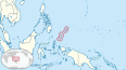
Palau, officially the Republic of Palau and historically Belau, Palaos or Pelew, is an island country in the western Pacific. The nation has approximately 340 islands and connects the western chain of the Caroline Islands with parts of the Federated States of Micronesia. It has a total area of 466 square kilometers. The most populous island is Koror, home to the country's most populous city of the same name. The capital Ngerulmud is located on the nearby island of Babeldaob, in Melekeok State. Palau shares maritime boundaries with international waters to the north, Micronesia to the east, Indonesia to the south, and the Philippines to the north west.

Palau was initially settled around 1000 BC.
The Trust Territory of the Pacific Islands (TTPI) was a United Nations trust territory in Micronesia administered by the United States from 1947 to 1994.
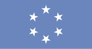
The flag of Palau was adopted on 1 January 1981, when the island group separated from the United Nations Trust Territory. As with the flags of several other Pacific island groups, light blue is the color used to represent the ocean and the nation's place within it. While this puts Palau in common with the Federated States of Micronesia and other neighboring island groups, the disc on the flag is off-centre like that of the flag of Bangladesh, but in this case the disc represents the moon instead of the sun. The current flag was introduced in 1981 when Palau became a republic.
In the law of the United States, an insular area refers to U.S.-associated jurisdictions not part of the 50 states or the District of Columbia. This includes fourteen U.S. territories administered under U.S. sovereignty, as well as three sovereign states each with a Compact of Free Association with the United States. The term also may be used to refer to the previous status of the Philippine Islands and the Trust Territory of the Pacific Islands when it existed.

Peleliu is an island in the island nation of Palau. Peleliu, along with two small islands to its northeast, forms one of the sixteen states of Palau. The island is notable as the location of the Battle of Peleliu in World War II.

The Compact of Free Association (COFA) is an international agreement establishing and governing the relationships of free association between the United States and the three Pacific Island sovereign states of the Federated States of Micronesia (FSM), the Republic of the Marshall Islands (RMI), and the Republic of Palau. As a result, these countries are sometimes known as the Freely Associated States.

Aimeliik is an administrative division of the island country of Palau. It is one of the Republic of Palau's 16 states. It has an area of 52 km² and a population of 334. State capital is the village of Mongami. Following the four other villages which are: Medorm, Imul, Elechui and Ngmechiangel.

Reservoir Hill, also known as Whitelock, is a neighborhood in the city of Baltimore, Maryland, United States. It is located south of Druid Hill Park, north of Bolton Hill, east of Penn-North, and west of Jones Falls. It is bounded by Druid Park Lake Drive, the Jones Falls Expressway, North Avenue, and McCulloh Street. It is contained in the 21217 ZIP code.

The House of Delegates of Palau is the lower house of the Palau National Congress, Palau's bicameral legislature. The Senate of Palau is the upper house. The House of Delegates has 16 members, each serving four-year terms in single-seat constituencies. Each state represents one constituency. No political parties exist. The last election was held on 3 November 2020.

The Sharps Island Light is the third lighthouse to stand nearly 3 miles (5 km) south-southwest from the southern end of Tilghman Island in Maryland's Chesapeake Bay. The structure is best known today for evoking the Leaning Tower of Pisa, a condition caused by an ice floe in 1977.

Xavier High School is a private Catholic coeducational high school run by the USA East Province of the Society of Jesus on the island of Weno in Chuuk, Federated States of Micronesia. It was established by the Jesuits in 1952. It was the first high school in the Trust Territory of the Pacific Islands. Bishop Thomas Feeney, S.J., D.D. from the New York Province of the Society of Jesus originally envisioned a minor seminary to train local clergy. Soon after, Xavier Seminary became the first college preparatory school in the Western Pacific.

The Airai Bai in Palauan is a traditional meetinghouse in the Airai municipality on Babeldaob, the largest island in the island nation of Palau. It is located in the center of the village on a stone platform that had previously held earlier bais, and is located at the junction of two traditional stone pathways. The building is 68 by 20 feet, rising to a height of 40 feet (12 m) at its peak. Its facade and interior beams are decorated with depictions of Palauan legends. It was built around 1890, and underwent a major restoration in the 1970s. The building and site have long been the spiritual and civic centerpiece of the community.
Meteu 'L Klechem is a historic stone monolith in Melekeok, a community on the island of Babeldaob, the largest island in the nation of Palau. It is a roughly octagonal stone, 7 feet (2.1 m) long and 2 feet (0.61 m) thick, and weighing about 3,000 pounds (1,400 kg). When recorded in 1976, it was used as a bridge across a local stream. The monolith is historically significant for its association with Metau, a warrior of the late 18th century. In 1785 Metau was ambushed and killed on Koror Island in revenge for attacks he had made on Yapese boats headed there. His body was held as a ransom, and was laid on this stone. Metau's brother Reklai paid the ransom, and in 1795 the stone and body were transported to Melekeok for burial. The stone sat at the main pier at Beriber until 1948, when it was moved to its present location.
Ongeluluul is a historic stone platform in Melekeok, a community on Babeldaob, the largest island of the island nation of Palau. It is located in Old Melekok Village, about 100 yards (91 m) from the boathouse at the shore. It is separated from the main road by a small creek. The platform measures about 20 by 20 feet, and was originally fashioned out of finely paved stones, although it was in deteriorated condition when surveyed in 1976. The site is of local historical significance as a place where important secret meetings of local leaders took place, and is a type of site other major Palauan communities have. This platform was erected in 1750, and was the site of two significant peace treaties in Palauan history: one in 1793 and the other in 1870. The latter peace treaty marked the end of organized warfare between the clans of Palau.
Koror City (KAW-rawr) is the largest city and its commercial center in Palau, home to about half of the country's population, located on Oreor Island. During the interwar period it served as the capital of the South Seas Mandate, a group of islands that made up the League of Nations mandated territory held by the Empire of Japan. It was subsequently the capital of Palau until it was replaced by Ngerulmud in 2006.
Palauan nationality law is regulated by the 1980 Constitution of Palau, as amended; the 1994 Palau Citizenship Act, and its revisions; and international agreements entered into by the Palauan government. These laws determine who is, or is eligible to be, a national of Palau. The legal means to acquire nationality, formal legal membership in a nation, differ from the domestic relationship of rights and obligations between a national and the nation, known as citizenship. Palauan nationality is typically obtained either on the principle of jus soli, i.e. by birth in Palau or under the rules of jus sanguinis, i.e. by birth abroad to parents with Palauan nationality. It can be granted to persons with an affiliation to the country through naturalization.