Ngatpang

Last updated
Ngatpang
Radio tower of Japanese army - panoramio.jpg
Radio tower of Japanese army, Ngatpang State
Ngatpang in Palau.svg
Location of Ngatpang in Palau
CountryFlag of Palau.svg  Palau
Capital Ngereklmadel
Area
  Total47 km2 (18 sq mi)
Population
 (2015 Census)
  Total289
  Density6.1/km2 (16/sq mi)
  Official languages
Palauan
English
ISO 3166 code PW-224

Ngatpang is one of Palau's sixteen states. It comprises an area of around 47 square kilometers in the west of Palau's largest island, Babeldaob, facing onto Ngeremeduu Bay. It has a population of 282, making it Palau's 9th largest state in population.

Contents

Ibobang is in Ngatpang. [1] It is a community dedicated to the practice of the Modekngei religion.

Geography

Ngatpang, which is located on the central west coast, includes a very large area of the interior to the southeast of Ngeremeduu Bay. Along the west coast, Ngatpang includes the narrow strip of land between Ngeremeduu Bay and the lagoon. This strip of land was ceded to Ngatpang from Aimeliik early in this century. The modern village of Mechebechubel is located in Ngereklmadel on the west coast on the south face of Roisengas. The terrain along this portion of the west coast is very rugged with steep slopes covered with thick forests. On the east side of Ngeremeduu Bay, Ngatpang extends to the Rael Kedam, the central divide on Babeldaob Island. The edges of the bay are lined with a thick fringe of mangrove swamp forest. Inland are rolling hills with short drainages. Many of the hills facing the bay are grass covered, but further inland the hills are covered with an upland forest. To the north lies the drainage of the Ngerbechederngul River, frequently referred to as the Yamato River . The major tributary of the Ngerbechederngul from Ngatpang is the Ngcholetel. In the southern part of the State are the drainages of the Ngatpang and Tabecheding Rivers. The Ngetmiich River, the largest tributary of the Tabecheding, drains the large interior region in the southeast part of the State. Along the edges of the bay, on the lower slopes of the hills, are deep, loamy soils which contain rich deposits of clay. South of the bay on the upland hills, the soils are thin and associated with scrub vegetation. Also associated with thin soils in low lying and poorly drained basins are bogs. [2]

Presently, most of the use of the land in Ngatpang is confined to gardens surrounding the modern villages of Mechebechubel and Ibobang. Interspersed with these kitchen gardens are stands of agroforest which include coconut, and betelnut, breadfruit, almond trees, and banana plants. In and around many of the uninhabited villages are stands of coconut and betelnut palms, and occasionally patches of irregularly attended taro swamp gardens. Except for occasional forays to hunt pigeon or harvest special plants, there is little active use of most of the interior of Ngatpang. [2]

Demography

The population of the state was 282 in the 2015 census and median age was 33.9 years. [3] The official languages of the state are Palauan and English. [4] Rekemesik is the title of the traditional high chief from the state. [5]

Political system

Ngatpang State follows a governance structure with an elected governor and legislative body, elected every four years. [6] The State's population elects one of the members of the House of Delegates of Palau.

Traditional villages

At least seven traditional village sites lie within Ngatpang: one on the west coast, five along the south and east sides of Ngeremeduu Bay, and one on the Ngcholetel River near its juncture with the Ngerbechederngul. These settlements were focused on the rich soil with a mixed forest on a thin strip of land along the coast, around the bay, and extending a short distance up the Ngerbechederngul. The rich deposits of clay around Ngimis are known traditionally as a source of pottery clay, and Ngimis is regarded as an important traditional center of pottery manufacture. In addition, traditional trails marked with small stone platforms led from Ngatpang villages to villages in Aimeliik, Airai, Ngchesar, Melekeok, and Ngeremlengui. [2]

The traditional villages represent important symbols giving identity to families, clans, and regions. Within villages are numerous stone features with historical and traditional importance. Many of the stone platforms, odesongel, serve as clan cemeteries, and other stone features serve as shrines. The lagoon and Ngeremeduu Bay are important resource areas, and were probably intensively exploited prehistorically. Important resources include the mangrove crab, many species of fish, and the mangrove tree. Near Ngimis and the other traditional villages are taro swamp gardens, and surrounding most village sites are garden plots and terraced hillsides. [2]

Transport

Within Ngatpang a network of roads now connects the two modern villages to Koror. The major north-south road begins at the Airai-Aimeliik Road above the Tabecheding and extends north, crossing the Tabecheding and Ngatpang Rivers, past Ngimis to Ibobang. A second road extends north west from Nekken (Aimeliik) to Mechebechubel winding its way through extremely rugged hills. A third road extends east from the Tabecheding to Simizu, Ngchesar, intersecting the north -south road about 2 km south of Ngimis. [2]

Education

The Ministry of Education operates public schools.

Ibobang Elementary School is in Ibobang. When it opened it relieved Ngatpang Elementary School. [7]

Palau High School in Koror is the country's only public high school, so many children from this community go there. [8] Others go to the Belau Modekngei School, a boarding school in Ibobang.

Related Research Articles

<span class="mw-page-title-main">Geography of Palau</span>

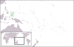
The Republic of Palau consists of eight principal islands and more than 250 smaller ones lying roughly 500 miles southeast of the Philippines, in Oceania. The islands of Palau constitute the westernmost part of the Caroline Islands chain. The country includes the World War II battleground of Peleliu and world-famous rock islands. The total land area is 459 km2 (177 sq mi). It has the 42nd largest Exclusive Economic Zone of 603,978 km2 (233,197 sq mi).

<span class="mw-page-title-main">Koror</span> State in Palau

Koror is the state comprising the main commercial centre of the Republic of Palau. It consists of several islands, the most prominent being Koror Island. It is Palau’s most populous state.

<span class="mw-page-title-main">Airai</span> State in Palau

Airai, located on the southern coast of Babeldaob island, is the second-most populous state of Palau. It contains the country's chief airport, Roman Tmetuchl International Airport, and is connected by the Koror–Babeldaob Bridge to nearby Koror Island.

<span class="mw-page-title-main">Peleliu</span> State in Palau

Peleliu is an island in the island nation of Palau. Peleliu, along with two small islands to its northeast, forms one of the sixteen states of Palau. The island is notable as the location of the Battle of Peleliu in World War II.

<span class="mw-page-title-main">Angaur</span> State in Palau

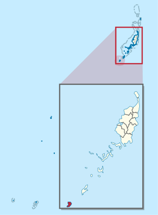
Angaur, or Ngeaur in Palauan, is an island and state in the island nation of Palau.

<span class="mw-page-title-main">Babeldaob</span> Largest island of Palau

Babeldaob is the largest island in the island nation of the Republic of Palau. It is in the western Caroline Islands, and the second largest island in the Micronesia region of Oceania. Palau's capital, Ngerulmud, is located on Babeldaob, in Melekeok State.

<span class="mw-page-title-main">Ngarchelong</span> State in Palau

Ngarchelong is a state in Palau. Ngarchelong is at the northernmost tip of the island of Babeldaob. Only the state of Kayangel is farther north.

<span class="mw-page-title-main">Aimeliik</span> State in Palau

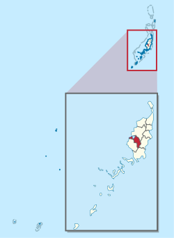
Aimeliik is an administrative division of the island country of Palau. It is one of the Republic of Palau's 16 states. It has an area of 52 km2 and a population of 334. State capital is the village of Mongami. Following the four other villages which are: Medorm, Imul, Elechui and Ngmechiangel.

<span class="mw-page-title-main">Ngchesar</span> State in Palau

Ngchesar also known as Oldiais is one of the sixteen states of the nation of Palau in Oceania.

<span class="mw-page-title-main">Ngaraard</span> State in Palau

Ngaraard is the eighth state of the Republic of Palau, and was originally named Kerradel.

Modekngei, or Ngara Modekngei, is a monotheistic religious movement founded around 1915 by Tamadad, a native of the island of Babeldaob, that spread throughout Palau. It rose to political significance between the First and Second World Wars and is currently professed by 5.7% of Palau's population. Modekngei is a hybrid of ancient Palauan customs and Christianity. Followers of the religion believe in the Christian God, recognize Jesus Christ as the Messiah, and simultaneously make appeasements to the traditional Palauan deities.

<span class="mw-page-title-main">Ngiwal</span> State in Palau

Ngiwal is one of the sixteen states of Palau. It has a population of 282 and an area of 26 km2

<span class="mw-page-title-main">Ngardmau</span> State in Palau

Ngardmau is one of Palau's sixteen states and is located on the west side of Babeldaob between the states of Ngaraard and Ngeremlengui.

<span class="mw-page-title-main">Ngeremlengui</span> State in Palau

Ngeremlengui is one of Palau's sixteen states. It has a population of 349, and is just west of the capital in Melekeok state. Among the 16 states of Palau, it’s the one with the lowest density but the one with the most neighbor states. It’s also the seventh most populous state.

<span class="mw-page-title-main">Melekeok</span> State in Palau

Melekeok is a state of the Republic of Palau located on the central east coast of Babeldaob Island. The seat of government of the country, Ngerulmud, is located in the state. The state consists of long beaches, hills, steep ridges, rivers, and the largest and only natural freshwater lake in Palau and Micronesia, Lake Ngardok.

<span class="mw-page-title-main">Roman Tmetuchl</span> Palauan politician and businessman (1926–1999)

Roman Tmetuchl was a Palauan political leader and businessman. He grew up in Japanese-controlled Palau and joined the Kempeitai, the Japanese secret police, during World War II. After the war, he became the leader of Palau's Liberal Party. He worked in the Congress of the Trust Territory of the Pacific Islands from 1964 to 1978 and advocated for Palau gaining a separate status from the rest of Micronesia. He became governor of Airai and engaged in three unsuccessful Palauan presidential campaigns. As a businessman, Tmetuchl led several construction projects for his business holdings and for the Palauan community, including the Palau International Airport and a Seventh-Day Adventist clinic.

<span class="mw-page-title-main">Index of Palau-related articles</span>

The following is an alphabetical list of topics related to the Republic of Palau.

The sport of baseball is widely played in Palau, having been introduced by the Japanese during their occupation of the island nation. The highest level of league play in Palau in represented by Palau Major League (PML), which is overseen by the Belau Baseball Federation. The country is represented in international play by the Palau national baseball team.

<span class="mw-page-title-main">Ministry of Education (Palau)</span> Government ministry in Palau

The Ministry of Education is a government agency of Palau, headquartered in Koror City.

Bkurrengel also known as Bkulrengel is a village in Aimeliik, Palau. It is located on the west coast of Babeldaob. The Palauan god Iechadrengel who created the sun and moon is said to have lived in Bkurrengel.

References

  1. Cook, Ben. Federated States of Micronesia and Palau. Other Places Publishing, 2010. ISBN   0982261934, 9780982261934. p. 207. " Only about 8% of Palauans practice Modekngei, most of whom reside in the same village, Ibobang. This small town of less than 100 in Ngatpang state[...]"
  2. 1 2 3 4 5 Snyder, David.; Adams, William Hampton; Butler, Brian M. (1997). Archaeology and historic preservation in Palau. Anthropology research series / Division of Cultural Affairs, Republic of Palau 2. San Francisco: U.S. National Park Service.
  3. "2015 Census of Population, Housing and Agriculture for the Republic of Palau" (PDF). Palau Government. Office of Planning and Statistics.
  4. Leonard, Thomas M. (2006). Encyclopedia of the Developing World. Taylor & Francis. ISBN   9780415976640.
  5. "Council of Chiefs – PalauGov.pw".
  6. "State/National Election Schedule". Palau Election Commission. 5 November 2020.
  7. "Ibobang Elementary School Archived 2018-08-09 at the Wayback Machine ." Ministry of Education (Palau). Retrieved on February 22, 2018.
  8. "About Archived 2018-03-03 at the Wayback Machine ." Palau High School. Retrieved on February 22, 2018.

PD-icon.svg This article incorporates public domain material from Snyder, David; Adams, William Hampton; Butler, Brian M. (1997). Archaeology and historic preservation in Palau. Anthropology research series / Division of Cultural Affairs, Republic of Palau 2. San Francisco: U.S. National Park Service.

7°28′N134°32′E / 7.467°N 134.533°E / 7.467; 134.533