Hatohobei Tobi | |
---|---|
![]() Location of Hatohobei in Palau | |
Country | ![]() |
Capital | Hatohobei |
Government | |
• Body | Hatohobei State Legislature |
• Governor | Ray Marino [1] |
Area | |
• Total | 0.9 km2 (0.3 sq mi) |
• Land | 0.9 km2 (0.3 sq mi) |
• Water | 0 km2 (0 sq mi) |
Population (2015 Census) | |
• Total | 25 [2] |
• Density | 8.3/km2 (21/sq mi) |
• Official languages | Palauan English Tobian |
ISO 3166 code | PW-050 |
Tobi, or Hatohobei [3] (Tobian), is the southernmost of Palau's sixteen states, [4] consisting of Tobi Island and Helen Reef. The total land area is about 0.88 km². The population was 25 in 2015. Tobian, English, and Sonsorolese are the official languages of Hatohobei State.
Not only is it Palau’s least populous state, but it is the least populous first-level administrative subdivision in the world as well as being the 13th smallest first level administrative subdivision.
The population of the state was 25 in the 2015 census and median age was 21.5 years. [5] Tobian, English, and Palauan are the official languages of Hatohobei State. [6]
In June 1972, the resident population was 79. [7] The population was 80 in 1962, 51 in 1995, 23 in 2000, and 25 in 2015.
Hatohobei has its own constitution, adopted in 1983. [8] The state government was established in 1984. The state of Hatohobei, with a population of 25, has an elected chief executive, the governor. The state also has a legislature elected every four years. [9] The state population elects one of the members of the House of Delegates of Palau.
Governors of Hatohobei until 2008:
Tochobei (Tobi) is located some 450 km southwest of Angaur. These small outer islands are both physically and culturally distinct from the rest of Palau. The islands are miniature platforms of raised reef composed of coralline limestone. The islands have sandy soils covered with atoll-like vegetation. Tochobei Island is low with a depressed, swampy interior. At least a part of the depression is the result of phosphate mining during the Japanese administration. Large stands of coconut palms line the beaches forming the primary resource for the only industry on the islands: copra production. Today, the islands are largely uninhabited as most of the native population lives in Koror or on Ngerekebesang Island. Even so, the natives retain a strong sense of cultural pride in their heritage and a firm commitment to their islands. [11]
The individual islands of Hatohobei, together with the islands of the state of Sonsorol, form the Southwest Islands of Palau.
No. | Island | Satellite picture | Area (km²) | Population (2015) | Coordinates |
---|---|---|---|---|---|
1 | Tobi (Hatohobei) | ![]() | 0.85 | 30 | 03°00′22″N131°07′26″E / 3.00611°N 131.12389°E |
2 | Helen Reef (Hotsarihie) | ![]() | 0.03 | 3 | 02°57′N131°47′E / 2.950°N 131.783°E |
3 | Transit Reef (Pieraurou) | - | - | - | 02°47′N132°32′E / 2.783°N 132.533°E |
State of Hatohobei | Hatohobei | 0.88 | 33 |
Tobi (Hatohobei or Kodgubi) Island was once the main island of the state (together with the permanently manned Marine Ranger Station on the second island, Helen Island). The land area is 0.85 km². Its highest point is 6 m, while most of the island is less than 3 m high. Most of the houses are situated in the abandoned village of Tobi (Hatohobei) on the southwestern side of the island, the state capital. The island is covered with coconut palms. A cultivated area was situated near the center of the island. The island is fringed by a reef that extends up to 800 m from the shore in the north.
Helen or Helens Reef (Hotsarihie), about 70 km east of Tobi Island, is a largely submerged atoll, with just one islet (Helen Island). The atoll is 25 km long and nearly 10 km wide, with a lagoon area of 103 km² and a total area including reef flat of 163 km². A channel leads into the lagoon from near the middle of the western side of the reef. Immediately south of the channel is Round Rock, which dries. The lagoon has about 85 patch and pinnacle Reefs.
When the tide is falling, the water flows out of the lagoon and over the reef in all directions until the reef is uncovered, and then flows out through the channel on the western side. On the rising tide, a reverse effect is noted. Only few parts of the reef completely dry.
Helen Island was discovered by the Spanish naval officer Felipe Tompson in 1773, who charted it as San Felix shoal. [12] The only island of the reef, it is located near its northern tip. It is tiny in comparison to Helen Reef, about 20 to 40 m wide and 400 m long, or about 0.03 km² of land area. The densely wooded island sits atop a sand dune, which is 0.25 km² in extent and which is moving southeast, falling into the lagoon, at a rate 3 to 4 m per year. The island is uninhabited except for a marine ranger station of Hatohobei State, which was established in the early 1990s on the eastern side of the island, to guard the reef against foreign poachers. The station is permanently occupied by a staff of three.
The island has been designated an Important Bird Area (IBA) by BirdLife International because it supports a breeding colony of black noddies, with some 25,000 birds estimated in 2004. There are also nesting populations of sooty and greater crested terns. [13]
50 km east of Helen Reef is Transit Reef (Pieraurou), which appears on some maps and which is referenced as an island in the Hatohobei State constitution and constitutes the southernmost feature of Palau. Its existence as island, however, is doubtful, as it is not listed in the current Sailing Directions. The literal translation of its Tobian name Pieraurou is "Sandy Navigation Point", referring to a submerged sand bar rather than a reef or island.
There is little information available on traditional village patterns in the Southwest Islands. Osborne noted several individual old dwelling places and one concentration of platforms and pathways. There is some information available on traditional fishing practices. The surrounding ocean provided the primary source of protein and was probably intensely exploited prehistorically. Given the limited amount of land, it is expected that almost all of it would have been intensively exploited by settlement or subsistence activities. [11]
The people of the Southwest Islands and Tochobei (Tobi) share a cultural heritage that shows close ties with peoples of the central Caroline Islands, more than 1000 km to the northeast and on the other side of Palau. The migration of these people to the Southwest Islands must be one of the truly remarkable events in the prehistory of the Pacific. [11] [ tone ]
Heimong is the title of the traditional high chief from the state. [14]
The Coral Sea Islands Territory is an external territory of Australia which comprises a group of small and mostly uninhabited tropical islands and reefs in the Coral Sea, north-east of Queensland, Australia. The only inhabited island is Willis Island. The territory covers 780,000 km2 (301,160 sq mi), most of which is ocean, extending east and south from the outer edge of the Great Barrier Reef and includes Heralds Beacon Island, Osprey Reef, the Willis Group and fifteen other reef/island groups. Cato Island is the highest point in the Territory.
Palau, officially the Republic of Palau, is an island country in the Micronesia subregion of Oceania in the western Pacific. The republic consists of approximately 340 islands and connects the western chain of the Caroline Islands with parts of the Federated States of Micronesia.
The Republic of Palau consists of eight principal islands and more than 250 smaller ones lying roughly 500 miles southeast of the Philippines, in Oceania. The islands of Palau constitute the westernmost part of the Caroline Islands chain. The country includes the World War II battleground of Peleliu and world-famous rock islands. The total land area is 459 km2 (177 sq mi). It has the 42nd largest Exclusive Economic Zone of 603,978 km2 (233,197 sq mi).
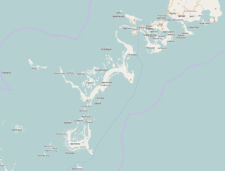
Koror is the state comprising the main commercial centre of the Republic of Palau. It consists of several islands, the most prominent being Koror Island. It is Palau’s most populous state.
Airai, located on the southern coast of Babeldaob island, is the second-most populous state of Palau. It contains the country's chief airport, Roman Tmetuchl International Airport, and is connected by the Koror–Babeldaob Bridge to nearby Koror Island.
Peleliu is an island in the island nation of Palau. Peleliu, along with two small islands to its northeast, forms one of the sixteen states of Palau. The island is notable as the location of the Battle of Peleliu in World War II.
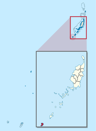
Angaur, or Ngeaur in Palauan, is an island and state in the island nation of Palau.
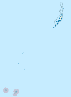
The Southwest Islands of Palau are several small islands spread across the Pacific Ocean about 600 km from the main island chain of Palau. They make up the Palauan states of Sonsorol and Hatohobei. The nearshore islands to the southwest of the main island of Palau (Babeldaob), which belong to the states of Koror, Peleliu and Angaur and the unincorporated Rock Islands, are not considered part of the Southwest Islands.
Ngarchelong is a state in Palau. It is at the northernmost tip of the island of Babeldaob. Only the state of Kayangel is farther north.
Aimeliik is an administrative division of the island country of Palau. It is one of the Republic of Palau's 16 states. It has an area of 52 km2 and a population of 334. The state capital is the village of Mongami. The four other villages are Medorm, Imul, Elechui and Ngmechiangel.
Ngchesar also known as Oldiais is one of the sixteen states of the nation of Palau in Oceania.
Tobian is the language of Tobi, one of the Southwest Islands of Palau, and the main island of Hatohobei state. Tobian is a Micronesian language spoken by approximately 150 people, about 22 are native speakers. The speakers are located in either the island of Tobi or in Echang, a hamlet of Koror, the former capital of Palau. Tobian and Sonsorolese are very close, and appear to be gradually merging towards a new dialect called "Echangese". Earlier in the 20th century, about 1000 people lived on the island. Shortly before and during the First World War, those numbers dropped severely due to an abundance of disease.
The Micronesians or Micronesian peoples are various closely related ethnic groups native to Micronesia, a region of Oceania in the Pacific Ocean. They are a part of the Austronesian ethnolinguistic group, which has an Urheimat in Taiwan.
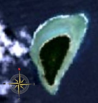
Kayangel (Ngcheangel) is the northernmost state of Palau 86 km (53 mi) north of Koror. The land area is about 1.4 km2 (0.54 sq mi). The population is 54. There is one hamlet in the state - Orukei, which is also its capital. In 2020, Richard Ngiraked was elected governor of the state.
Ngiwal is one of the sixteen states of Palau. It has a population of 282 and an area of 26 km2
Ngatpang is one of Palau's sixteen states. It comprises an area of around 47 square kilometers in the west of Palau's largest island, Babeldaob, facing onto Ngeremeduu Bay. It has a population of 282, making it Palau's 9th largest state in population.
Melekeok is a state of the Republic of Palau located on the central east coast of Babeldaob Island. The seat of government of the country, Ngerulmud, is located in the state. The state consists of long beaches, hills, steep ridges, rivers, and the largest and only natural freshwater lake in Palau and Micronesia, Lake Ngardok.
Tobi is an island in the Palauan state of Hatohobei. Tobi Island is 1.6 km long and 0.8 km wide, and has an area of about 0.85 square kilometres (0.33 sq mi). With a population of 39 according to a 2020 census, it holds all of the state's people, with the exception of a weather base on Helen Island. Most of the inhabitants live on the island's west side and speak Tobian.
Sonsorol is one of the sixteen states of Palau. The inhabitants speak Sonsorolese, a local Chuukic language, and Palauan.
A constitutional referendum was held in Palau on 1 May 2020. Voters were asked whether they approved of an amendment to article 1 of the constitution, which defined its maritime borders. The proposal was approved by 97% of voters.
{{cite web}}
: CS1 maint: DOI inactive as of November 2024 (link) This article incorporates public domain material from Snyder, David.; Adams, William Hampton; Butler, Brian M. (1997). Archaeology and historic preservation in Palau. Anthropology research series / Division of Cultural Affairs, Republic of Palau 2. San Francisco: U.S. National Park Service.