Melekeok

Last updated
Melekeok
Melekeok in Palau.svg
Location of Melekeok in Palau
CountryFlag of Palau.svg  Palau
Capital Melekeok
Area
  Total25 km2 (10 sq mi)
Population
 (2020 Census)
  Total318
  Density13/km2 (33/sq mi)
  Official languages
Palauan
English
ISO 3166 code PW-212
Map of State of Melekeok State of Melekeok.png
Map of State of Melekeok

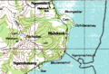
Melekeok is a state of the Republic of Palau located on the central east coast of Babeldaob Island. The seat of government of the country, Ngerulmud, is located in the state. The state consists of long beaches, hills, steep ridges, rivers, and the largest and only natural freshwater lake in Palau and Micronesia, Lake Ngardok.

Contents

Political system

The state of Melekeok, with population of 318, has an elected chief executive and a governor.[ citation needed ] The state also has a legislature elected every four years; its population elects one of the members in the House of Delegates of Palau. [1]

Geography

Melekeok, located on the central east coast of Babeldaob, includes long stretches of sandy beaches and the broad Ngerdorch River valley which begins at Lake Ngerdok, the largest fresh water lake in Palau. Melekeok extends from the lagoon on the east coast to the Rael Kedam, the central divide on Babeldaob Island, and situated between Ngiwal on the north and by Ngchesar on the south. To the west, Melekeok is bounded by Ngeremlengui. The interior of the state is composed of steeply dissected rolling hills with swampy marshes lining sluggish drainages. Thick forests cover the east flanks of the Rael Kedam, and the sandy beaches are lined with coconut palms, but much of the interior is covered with sparse vegetation. A thin fringe of mangroves emerges along the northern and southern stretches of coast, but is lacking for most of the central coast. A ridge system parallels the coast and the prominent Tochobei Hill is situated near the center of this system. A series of small ridges descend like fingers from the main ridge system to the coast. [2] Melekeok State is approximately 11 square miles (28 km2) in total area.

The capitol building of Palau, Melekeok Capitol, Melekeok, Palau.jpg
The capitol building of Palau, Melekeok

Melekeok's Lake Ngardok is the largest natural body of fresh water in all of Micronesia at 4.93 square kilometres (1.90 sq mi); it has a small population of saltwater crocodiles Crocodylus porosus.

Presently, most land use in Melekeok is confined to gardens surrounding the modern villages of Ngerubesang, Ngerang Ngerames, Ngermelech, and Ngeruliang. Melekeok Village and sometimes Ngeburch are also recognized as hamlets of Melekeok, and in fact, administrative control for much of Melekeok is held by Melekeok Village. Interspersed with these kitchen gardens are stands of agroforest which include coconut, betelnut, breadfruit, almond trees, and banana plants. In and around many of the uninhabited villages are stands of coconut and betelnut palms, and occasionally patches of irregularly attended taro swamp gardens. [2]

Demography

The population of the state was 277 in the 2015 census and median age was 37.3 years. [3] The official languages of the state are Palauan and English. [4] Reklai is the title of the traditional high chief from the state. [5]

According to the 2005 census, 391 people resided in the State of Melekeok. [6] They are distributed among seven villages, with Melekeok being the largest. The new capital, Ngerulmud, had not been established at the time of the census.

  1. Melekeok (271)
  2. Ertong (20)
  3. Ngeburch (34)
  4. Ngeremecheluch (38)
  5. Ngermelech (5)
  6. Ngerubesang (12)
  7. Ngeruling (21)

The State of Melekeok consists of eight inhabited villages: Ngeburch, Ngeruling, Ngermelech, Melekeok, Ngerubesang, Ngeremecheluch, Ertong, Ngerulmud. The state capitol is located in the settlement of Ngerulmud. The Republic of Palau's Capitol Complex is located on a hill, northwest of the village of Melekeok.

Education

The Ministry of Education operates public schools.

The Melkeok Elementary School consists of a two-story building. [7]

The Palau High School in Koror is the country's only public high school, so children from this community go there. [8]

Transport

Within Melekeok, a paved road connects the four modern villages . A bladed road runs to the packed earth airstrip, and connects Melekeok with southern Babeldaob. [2]

Tourism

Apart from its natural beauties and the Capitol, there are several registered places of interest:

Beach of Melekeok State Beach-in-melekeok20071222.jpg
Beach of Melekeok State

Related Research Articles

<span class="mw-page-title-main">Palau</span> Country in the western Pacific

Palau, officially the Republic of Palau, is an island country in the Micronesia subregion of Oceania in the western Pacific. The republic consists of approximately 340 islands and connects the western chain of the Caroline Islands with parts of the Federated States of Micronesia. It has a total area of 466 square kilometers (180 sq mi), making it one of the smallest countries in the world. The most populous island is Koror, home to the country's most populous city of the same name. The capital Ngerulmud is located on the largest island of Babeldaob, in Melekeok State. Palau shares maritime boundaries with international waters to the north, the Federated States of Micronesia to the east, Indonesia to the south, and the Philippines to the northwest.

<span class="mw-page-title-main">Geography of Palau</span>

The Republic of Palau consists of eight principal islands and more than 250 smaller ones lying roughly 500 miles southeast of the Philippines, in Oceania. The islands of Palau constitute the westernmost part of the Caroline Islands chain. The country includes the World War II battleground of Peleliu and world-famous rock islands. The total land area is 459 km2 (177 sq mi). It has the 42nd largest Exclusive Economic Zone of 603,978 km2 (233,197 sq mi).

<span class="mw-page-title-main">Demographics of Palau</span>

Demographic features of the population of Palau include population density, ethnicity, education level, health of the populace, economic status, religious affiliations and other aspects.

<span class="mw-page-title-main">Koror</span> State in Palau

Koror is the state comprising the main commercial centre of the Republic of Palau. It consists of several islands, the most prominent being Koror Island. It is Palau’s most populous state.

<span class="mw-page-title-main">Airai</span> State in Palau

Airai, located on the southern coast of Babeldaob island, is the second-most populous state of Palau. It contains the country's chief airport, Roman Tmetuchl International Airport, and is connected by the Koror–Babeldaob Bridge to nearby Koror Island.

<span class="mw-page-title-main">Peleliu</span> State in Palau

Peleliu is an island in the island nation of Palau. Peleliu, along with two small islands to its northeast, forms one of the sixteen states of Palau. The island is notable as the location of the Battle of Peleliu in World War II.

<span class="mw-page-title-main">Babeldaob</span> Largest island of Palau

Babeldaob is the largest island in the island nation of the Republic of Palau. It is in the western Caroline Islands, and the second largest island in the Micronesia region of Oceania. Palau's capital, Ngerulmud, is located on Babeldaob, in Melekeok State.

<span class="mw-page-title-main">Ngarchelong</span> State in Palau

Ngarchelong is a state in Palau. Ngarchelong is at the northernmost tip of the island of Babeldaob. Only the state of Kayangel is farther north.

<span class="mw-page-title-main">Aimeliik</span> State in Palau

Aimeliik is an administrative division of the island country of Palau. It is one of the Republic of Palau's 16 states. It has an area of 52 km² and a population of 334. State capital is the village of Mongami. Following the four other villages which are: Medorm, Imul, Elechui and Ngmechiangel.

<span class="mw-page-title-main">Ngchesar</span> State in Palau

Ngchesar also known as Oldiais is one of the sixteen states of the nation of Palau in Oceania.

<span class="mw-page-title-main">Ngaraard</span> State in Palau

Ngaraard is the eighth state of the Republic of Palau, and was originally named Kerradel.

<span class="mw-page-title-main">Ngiwal</span> State in Palau

Ngiwal is one of the sixteen states of Palau. It has a population of 282 and an area of 26 km2

<span class="mw-page-title-main">Melekeok (town)</span> City in Melekeok

Melekeok is a town in the State of Melekeok. It is located on the east coast of Palau's largest island, Babeldaob.

<span class="mw-page-title-main">Ngardmau</span> State in Palau

Ngardmau is one of Palau's sixteen states and is located on the west side of Babeldaob between the states of Ngaraard and Ngeremlengui.

<span class="mw-page-title-main">Ngatpang</span> State in Palau

Ngatpang is one of Palau's sixteen states. It comprises an area of around 47 square kilometers in the west of Palau's largest island, Babeldaob, facing onto Ngeremeduu Bay. It has a population of 282, making it Palau's 9th largest state in population.

<span class="mw-page-title-main">Ngeremlengui</span> State in Palau

Ngeremlengui is one of Palau's sixteen states. It has a population of 349, and is just west of the capital in Melekeok state. Among the 16 states of Palau, it’s the one with the lowest density but the one with the most neighbor states. It’s also the seventh most populous state.

<span class="mw-page-title-main">Lake Ngardok</span>

Lake Ngardok is a lake on the Palauan island of Babeldaob, in the State of Melekeok. It is the largest natural freshwater lake in all of the islands of Micronesia. The lake and the marshes surrounding it are a refuge for the endangered saltwater crocodile (ius), and it is an important breeding location for them. The Ngerdorch River serves as a route that connects crocodiles with the sea. The lake is approximately 493 hectares with an ecosystem that provides a habitat for plants, wildlife, and birds, some of which are found only in the Palau Islands. These include the endemic Palau fruit dove (biib), Palau fantail (melimdelebdeb), Micronesian imperial-pigeon (belochel), common moorhens and Pacific black ducks, Palau flycatcher (charmelachull), and a fruit bat species (olik). The Chief Council of Melekeok State has established the Ngardok Nature Reserve to protect the watershed's slow degradation process, because the importance of the forests are critical to preserving the water quality in the lake. The lake however will soon be established as a reservoir for Ngerulmud, Palau's new national capital in Melekeok.

<span class="mw-page-title-main">Outline of Palau</span> Overview of and topical guide to Palau

The following outline is provided as an overview of and topical guide to Palau:

<span class="mw-page-title-main">Index of Palau-related articles</span>

The following is an alphabetical list of topics related to the Republic of Palau.

<span class="mw-page-title-main">Ngerulmud</span> Capital city of Palau

Ngerulmud is the seat of government of the Republic of Palau, an island nation in the Pacific Ocean. It replaced Koror City as a capital in 2006. The settlement is located in the state of Melekeok on Babeldaob, the country's largest island, located 20 kilometers northeast of Koror City and 2 km northwest of Melekeok City. It is the least-populous capital city of a sovereign nation in the world. With not even 300 inhabitants it’s one of the smallest capitals on earth.

References

  1. "State/National Election Schedule". Palau Election Commission. 5 November 2020.
  2. 1 2 3 Snyder, David.; Adams, William Hampton; Butler, Brian M. (1997). Archaeology and historic preservation in Palau. Anthropology research series / Division of Cultural Affairs, Republic of Palau 2. San Francisco: U.S. National Park Service.
  3. "2015 Census of Population, Housing and Agriculture for the Republic of Palau" (PDF). Palau Government. Office of Planning and Statistics.
  4. Leonard, Thomas M. (2006). Encyclopedia of the Developing World. Taylor & Francis. ISBN   9780415976640.
  5. "Council of Chiefs – PalauGov.pw".
  6. "Palau Census 2005" (PDF).
  7. "Melkeok Elementary School Archived 2018-08-09 at the Wayback Machine ." Ministry of Education (Palau). Retrieved on February 22, 2018.
  8. "About Archived 2018-03-03 at the Wayback Machine ." Palau High School. Retrieved on February 22, 2018.

PD-icon.svg This article incorporates public domain material from Snyder, David.; Adams, William Hampton; Butler, Brian M. (1997). Archaeology and historic preservation in Palau. Anthropology research series / Division of Cultural Affairs, Republic of Palau 2. San Francisco: U.S. National Park Service.

7°29′N134°36′E / 7.483°N 134.600°E / 7.483; 134.600