Google Maps is a web mapping platform and consumer application offered by Google. It offers satellite imagery, aerial photography, street maps, 360° interactive panoramic views of streets, real-time traffic conditions, and route planning for traveling by foot, car, bike, air and public transportation. As of 2020, Google Maps was being used by over 1 billion people every month around the world.

Google Earth is a computer program that renders a 3D representation of Earth based primarily on satellite imagery. The program maps the Earth by superimposing satellite images, aerial photography, and GIS data onto a 3D globe, allowing users to see cities and landscapes from various angles. Users can explore the globe by entering addresses and coordinates, or by using a keyboard or mouse. The program can also be downloaded on a smartphone or tablet, using a touch screen or stylus to navigate. Users may use the program to add their own data using Keyhole Markup Language and upload them through various sources, such as forums or blogs. Google Earth is able to show various kinds of images overlaid on the surface of the earth and is also a Web Map Service client. In 2019, Google has revealed that Google Earth now covers more than 97 percent of the world, and has captured 10 million miles of Street View imagery.
Keyhole Markup Language (KML) is an XML notation for expressing geographic annotation and visualization within two-dimensional maps and three-dimensional Earth browsers. KML was developed for use with Google Earth, which was originally named Keyhole Earth Viewer. It was created by Keyhole, Inc, which was acquired by Google in 2004. KML became an international standard of the Open Geospatial Consortium in 2008. Google Earth was the first program able to view and graphically edit KML files, but other projects such as Marble have added KML support.

Proceratium google, also known as the Google ant, was discovered in Madagascar by Brian L. Fisher, Associate Curator of Entomology at the California Academy of Sciences. The ant has an oddly shaped abdomen, adapted for hunting its exclusive meal of spider eggs.

Panoramio was a geo-located tagging, photo sharing mashup active between 2005 and 2016. Photos uploaded to the site were accessible as a layer in Google Earth and Google Maps. The site's goal was to allow Google Earth users to learn more about a given area by viewing the photos that other users had taken at that location. Panoramio was acquired by Google in 2007. In 2009 the website was among 1000 most popular websites worldwide.
ImageAmerica is an aerial photography company that was acquired by Google in July 2007. The company specialized in creating aerial photos with "accuracy, quick delivery and low cost". It previously sold its services primarily to city, county, state, and federal governments and to corporate customers. ImageAmerica also made money by selling low-cost imagery to county appraisers and assessors. The company's clients include the Texas Department of Transportation, the U.S. Geological Survey, and the Lucas County office that covers Toledo, Ohio. For satellite imaging, the company charges US$99 per 1 square mile (2.6 km2), compared to other companies which could charge from $500 to $700 and for a lower quality than what ImageAmerica offers. It also developed its own DDP-2 camera system. The system is housed in an aircraft. It has the ability to capture details as small as 6 inches (150 mm) to 12 inches (300 mm). ImageAmerica's patented processing system has the ability to produce orthorectified imagery corrected for perspective distortions. The company's technology also uses sensors which are based on a unique design from Sarnoff Research Labs in Princeton, New Jersey.
Endoxon is an Internet mapping solutions company that was partially acquired by Google in December 2006. The company is based in Lucerne, Switzerland. Endoxon now provides the maps for European countries in Google Maps. Its products included maps that have geo-referenced data with high-resolution aerial and satellite images for dynamic internet and mobile services.

A continent is any of several large landmasses. Continents are generally identified by convention rather than any strict criteria. Due to this, the number of continents varies; up to seven or as few as four geographical regions are commonly regarded as continents. Most English-speaking countries recognize seven regions as continents. In order from largest to smallest in area, these seven regions are Asia, Africa, North America, South America, Antarctica, Europe, and Australia. Different variations with fewer continents merge some of these regions, examples of this are merging North America and South America into America, Asia and Europe into Eurasia, and Africa, Asia, and Europe into Afro-Eurasia.

A partial solar eclipse occurred on December 4, 1964. A solar eclipse occurs when the Moon passes between Earth and the Sun, thereby totally or partly obscuring the image of the Sun for a viewer on Earth. A partial solar eclipse occurs in the polar regions of the Earth when the center of the Moon's shadow misses the Earth.
Google Building Maker was a web application that allowed users to build three-dimensional buildings for inclusion in Google Earth. Buildings were created using simple three-dimensional shapes combined with aerial photos. Google reviewed new building submissions and included them in Google Earth's three-dimensional buildings layer when they were of sufficient quality and a better model did not already exist. Building models could be exported for editing in SketchUp. There were at least 127 cities available.
Google Crisis Response is a team within Google.org that "seeks to make critical information more accessible around natural disasters and humanitarian crises". The team has responded in the past to the 2010 Haiti earthquake, 2010 Pakistan floods, 2010–11 Queensland floods, February 2011 Christchurch earthquake, and the 2011 Tōhoku earthquake and tsunami among other events, using Google resources and tools such as Google Maps, Google Earth, Google Person Finder, and Google Fusion Tables.
Google Street View was first introduced in the United States on May 25, 2007, and until November 26, 2008, featured camera icon markers, each representing at least one major city or area, and usually the other nearby cities, towns, suburbs, and parks. Many areas that had coverage were represented by icons.

Miss Earth 2013, the 13th edition of the Miss Earth pageant, was held on December 7, 2013 at the Versailles Palace in Las Piñas, Metro Manila, Philippines. Tereza Fajksová of the Czech Republic crowned her successor Alyz Henrich of Venezuela at the end of the event.
Google APIs are application programming interfaces (APIs) developed by Google which allow communication with Google Services and their integration to other services. Examples of these include Search, Gmail, Translate or Google Maps. Third-party apps can use these APIs to take advantage of or extend the functionality of the existing services.

Project Sunroof is a solar power initiative started by Google engineer Carl Elkin. The initiative's stated purpose is "mapping the planet's solar potential, one roof at a time."
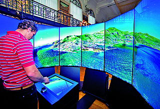
The Liquid Galaxy is an open source project founded by Google. Created in 2008 by Google employee Jason Holt, the Liquid Galaxy started out as a panoramic multi-display Google Earth viewer, but has evolved to become a general data visualization tool for operations, marketing, and research.
Where on Google Earth is Carmen Sandiego? is a series of three video games utilising Google Earth released as tie-ins to the animated series released in the same year. To develop the series, Houghton Mifflin Harcourt partnered with Google. The games utilize the Google Earth software, and runs as an add-on that can be played by clicking the icon of Carmen Sandiego. The game is played by Google's Chrome web browser on a PC, or with the Google Earth app on iOS and Android devices. It aims to be a reimagining of the original 1985 video game, using Google Earth.
The Billion Dollar Code is a 2021 German television miniseries starring Björn Freiberg, Seumas F. Sargent and Leonard Scheicher. Based on true events, the series was developed for Netflix, where it was first aired in October 2021 along with an additional feature story episode.