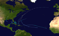
The 1982 Atlantic hurricane season was a well-below average Atlantic hurricane season with five named tropical storms and one subtropical storm. Two storms became hurricanes, one of which reached major hurricane status. The season officially began on June 1, 1982, and lasted until November 30, 1982. These dates conventionally delimit the period of each year when most tropical cyclones form in the Atlantic basin. Activity started early with Hurricane Alberto forming on the first day of the season. Alberto threatened the Southwestern Florida coast as a tropical storm, meadering offshore in the southeastern Gulf of Mexico and causing 23 fatalities in Cuba. The next system, a subtropical storm, formed later in June and affected the same area as Alberto, causing $10million in damage.
Tropical Storm Beryl formed on August 28, after a quiet July in the open Atlantic Ocean. Beryl grazed Cape Verde, killing 3people. Tropical Depression Three formed just behind Beryl, tracking east and north of the Caribbean sea in early September. Soon after the dissipation of Beryl, Tropical Storm Chris formed in the Gulf of Mexico on September 9. Chris stayed a weak storm, making landfall near Sabine Pass, Texas, and dissipating over land on September 13. Hurricane Debby was the next storm and the strongest of the season. The formative stage of Debby produced rainfall in Puerto Rico, causing one death on the island, and soon strengthened into a Category4 major hurricane. Debby passed by Newfoundland on September 18 and merged with a non-tropical low on September 20. In mid-September, Tropical Depression Six formed west of Africa, and tracked west-northwest, dissipating before reaching the Leeward Islands on September 20. Its remnant thunderstorm activity continued moving west-northwest, forming Tropical Depression Seven which moved near Bermuda on September 25 before dissipating offshore Nova Scotia. The final storm of the season, Tropical Storm Ernesto, was the shortest-lasting system and stayed out to sea, dissipating on October 3.
Season summary
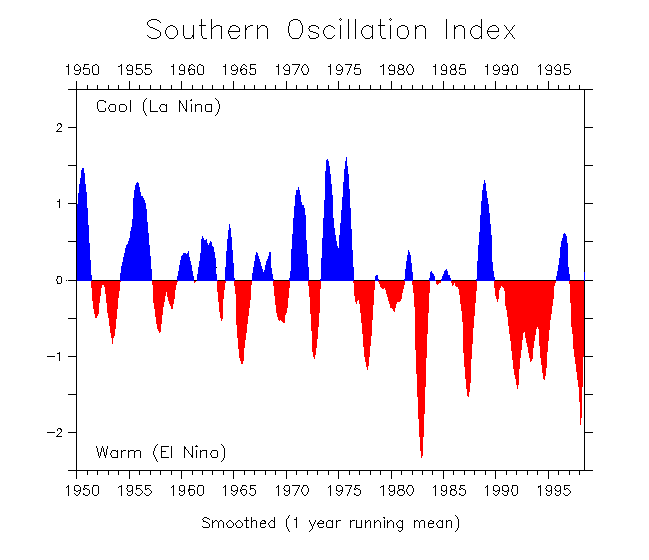
The 1982Atlantic hurricane season officially began on June1 and ended on November30.[1] The season was very inactive because of strong vertical wind shear due to stronger than normal westerly winds aloft.[2] The wind shear was contributed by a variety of factors including a very strong El Niño. Vertical wind shear was strong enough to disrupt convection in areas of disturbed weather so they could not develop further. The El Niño which affected this hurricane season extended into the 1983 Atlantic hurricane season.[3] Higher than average values of African mineral dust during the most active portion of the hurricane season could have also suppressed tropical cyclone activity.[4]
The season's activity was reflected with a cumulative accumulated cyclone energy (ACE) rating of 32,[5] which is classified as "below normal".[6] ACE is, broadly speaking, a measure of the power of the hurricane multiplied by the length of time it existed, so storms that last a long time, as well as particularly strong hurricanes, have high ACEs. ACE is only calculated for full advisories on tropical systems at or exceeding 34 knots (39mph; 63km/h) or tropical storm strength. Although officially, subtropical cyclones are excluded from the total,[7] the figure above includes periods when fully tropical storms were in a subtropical phase.
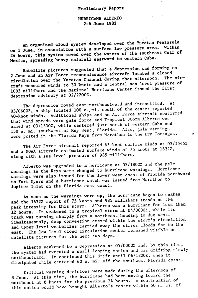
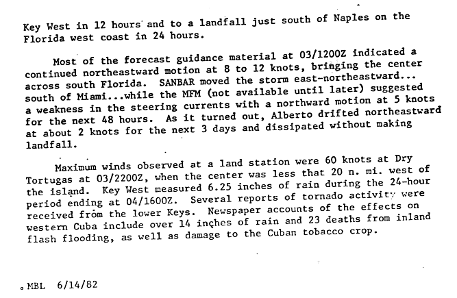
A surface low-pressure area developed an organized cloud system, leading to the formation of a tropical depression off the northeastern Yucatán Peninsula on June2. It moved slowly northeastward through the Gulf of Mexico, and strengthened into Tropical Storm Alberto on the next day. Alberto traveled generally northeast on an erratic course, and briefly intensified to a Category1 hurricane,[8] one of the earliest hurricanes of June, and the earliest date for a hurricane in the Atlantic Ocean since Hurricane Alma in May 1970.[9] Due to strengthening vertical wind shear, Alberto then quickly weakened into a tropical storm, doubled back to the west, and dissipated near the Florida Keys on June6.[8] Alberto is an example of a storm to enter the Gulf of Mexico and dissipating while never making landfall,[10] which is an unusual event.[11]
Though Alberto never made landfall, the storm dropped more than 14in (360mm) of rain over western Cuba.[12] This led to severe flooding, considered the worst in that part of the country since 1950.[13] Over 50,000people were forced to evacuated and approximately 9,000homes in Pinar del Río Province alone suffered damaged.[14][15] Severe crop and agricultural losses also occurred, particularly to bananas and tobacco.[12][16] Overall, Alberto caused 23deaths and an estimated $85million in damage in Cuba.[17] Southern Florida experienced moderate rainfall, with a peak of 16.47in (418mm) occurring in Tavernier.[18] The storm also spawned a few tornadoes and a waterspout in the Florida Keys, collectively causing approximately $275,000 in damage.[19][20]
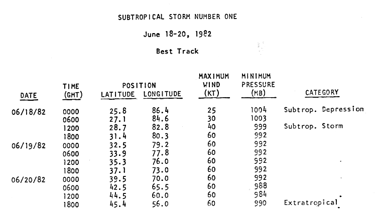
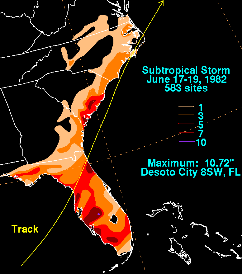
In mid-June, a tropical disturbance over the Yucatán Peninsula interacted with an upper-level trough, leading to the development of a low-pressure center.[21] After emerging into the Gulf of Mexico, the low organized into a subtropical depression at 00:00UTC on June18 about 285mi (460km) west-southwest of Naples, Florida. Twelve hours later, the system intensified into a subtropical storm shortly before making landfall near Homosassa, Florida.[22] Moving quickly northeastward, the subtropical storm crossed the peninsula in only about four hours and emerged into the Atlantic from the First Coast.[21] Late on June18, sustained winds associated with the storm peaked at 70mph (110km/h). The system crossed the Outer Banks of North Carolina on the following day. Paralleling the coast of Nova Scotia on June20, the storm's minimum pressure fell to 984mbar (29.1inHg), shortly before becoming extratropical about 100mi (160km) south of Saint Pierre and Miquelon.[22]
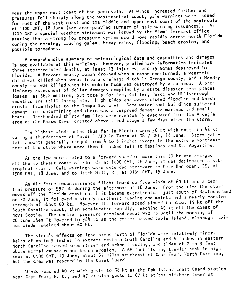
As the subtropical storm crossed Florida on June18, numerous severe thunderstorm and tornado warnings were issued.[23] The cyclone also dropped heavy rainfall, peaking at 10.72in (272mm)eightmi (13km) southwest of DeSoto County.[24] In that county, 130families evacuated from Arcadia after the Peace River rose significantly. A total of 25homes were destroyed in Florida, while some buildings, boats, and marinas from Naples to the Tampa Bay area suffered damage. The cyclone also killed three people in the state. In North Carolina, stream and urban flooding and minor beach erosion occurred. A fishing trawler also capsized offshore.[23] Overall, the storm caused about $10million in damage. This was the only subtropical or tropical cyclone to impact the Eastern seaboard this season.[2]
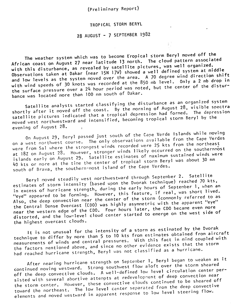
A tropical wave quickly organized into a tropical depression southeast of the Cabo Verde Islands on August28. Shortly thereafter, it intensified into Tropical Storm Beryl. On August 29, Beryl passed just south of the islands while moving west-northwestward.[25] Beryl produced heavy rains and gusty winds on the Cabo Verde Islands. The storm rendered approximately 2,100people homeless and caused about $3million in damage.[17][26] Additionally, at least 3people died and another 122others suffered injuries. [26] In the period after the storm's passage, the United States provided humanitarian aid and economic assistance to the country, helping the archipelago to reverse the effects of Beryl.[27]
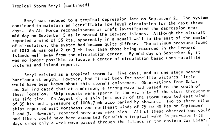
An eye feature appeared in the convection on August 31, but it was located on the western side of the deep convection and the storm was slightly asymmetric. Consequently, the intensity was held just below hurricane status.[25] Shortly after, strong wind shear exposed the storm's low-level circulation and caused Beryl to weaken,[25] falling to tropical depression status on September2 while turning westward. On September 5, a reconnaissance flight found winds of 65mph (105km/h); this was deemed unrepresentative of the storm's actual intensity as it was recorded in a squall line. The depression became disorganized once more and was last identifiable on satellites about 95mi (155km) north of the Leeward Islands on September6.[28]
This system formed about 525mi (845km) east of the Lesser Antilles on September6 and to the southeast of Tropical Storm Beryl.[10] Due to unfavorable conditions, the National Hurricane Center (NHC) did not expect the cyclone to intensify significantly.[29] The depression failed to strengthen beyond maximum sustained winds of 35mph (55km/h) and moved northwestward to west-northwestward until dissipating about 380mi (610km) north of Puerto Rico on September9.[10]
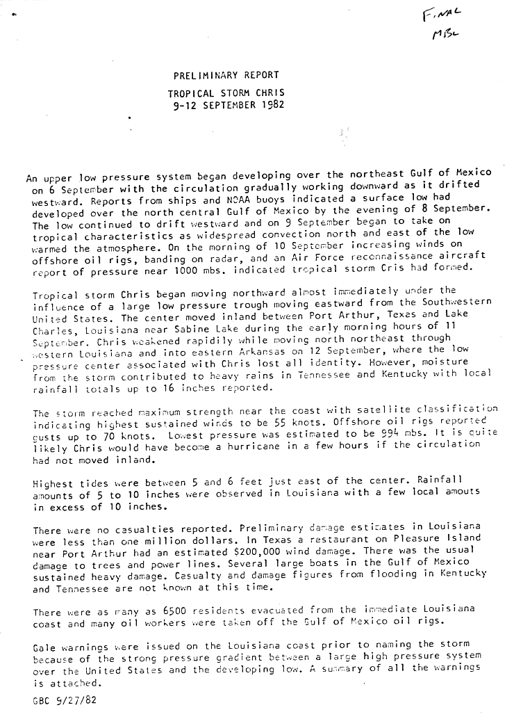
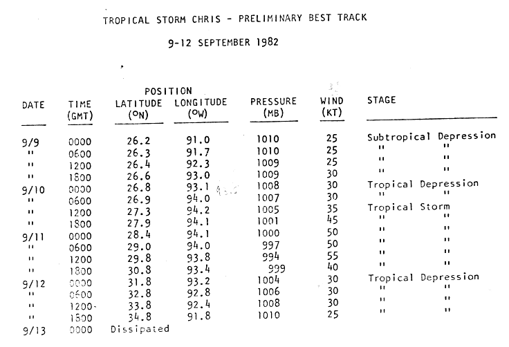
A surface low-pressure area developed on September 8 in the Gulf of Mexico.[30] It drifted westward and organized into a subtropical depression on the following day about 200mi (320km) south of the coast of Louisiana.[31] Under the influence of a trough of low pressure, the storm turned northward and transitioned into a tropical depression early on September10. Several hours later, the depression intensified into Tropical Storm Chris. The storm attained peak winds of 65mph (100km/h) and a minimum pressure of 994mbar (29.4inHg) before moving ashore near Sabine Pass in Texas. Chris continued inland until it dissipated over central Arkansas on September 13.[30]
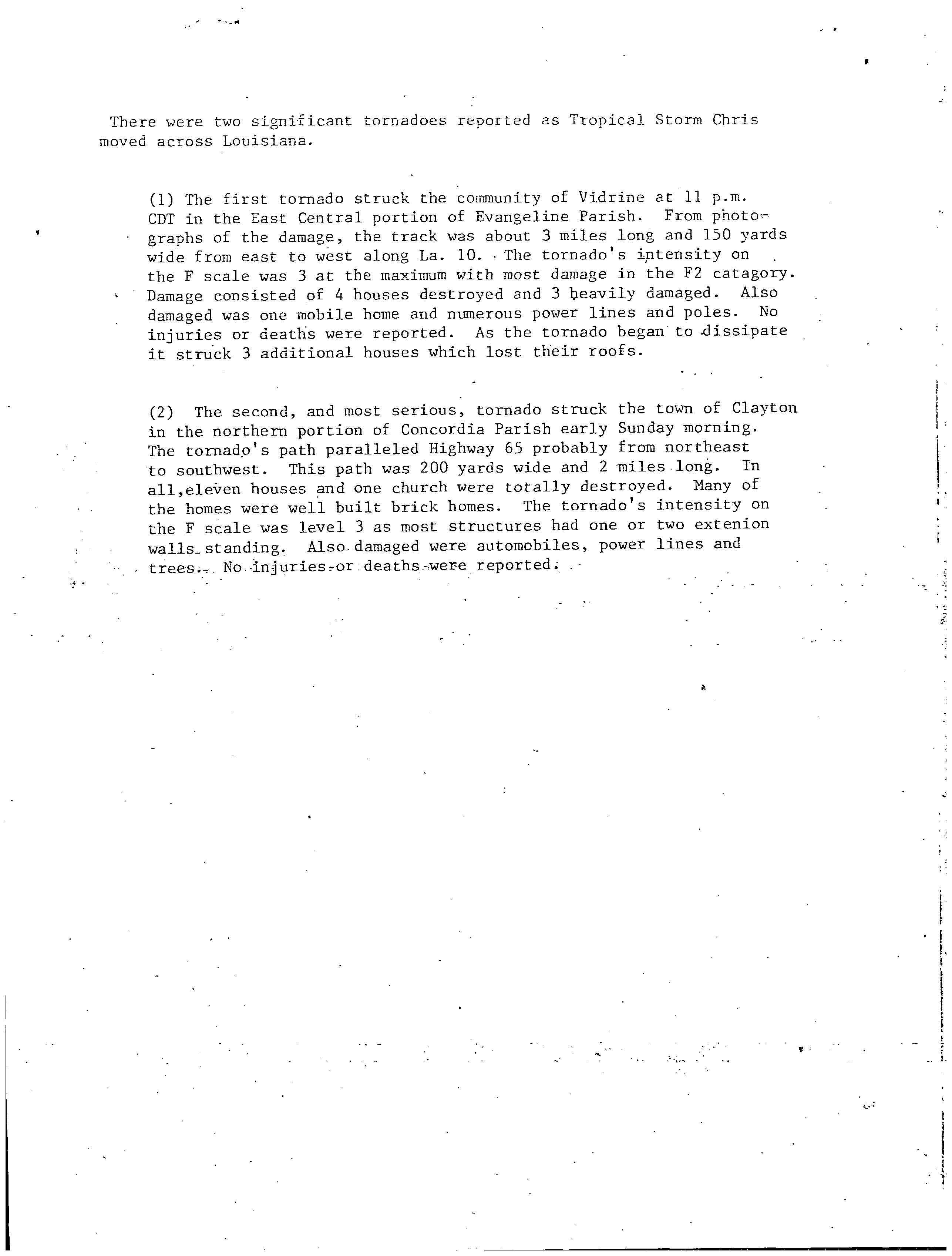
Prior to making landfall, as many as 6,500people evacuated from southern Louisiana, while offshore many oil workers were evacuated inland. Chris produced moderate rainfall along its path, peaking at 16in (410mm) in Delhi, Louisiana, with totals of over 10in (250mm) in Mississippi and Tennessee.[32] The rainfall caused locally severe flooding as far inland as Tennessee and Kentucky, with flooding of some rivers reported.[33] The storm spawned nine tornadoes, of which four were F2 or stronger on the Fujita scale,[34] two of which damaged seven structures and destroyed sixteen others combined in Louisiana.[35] Upon moving ashore, the hurricane produced a 5 to 6ft (1.5 to 1.8m)storm tide, resulting in severe damage to several boats in the Gulf of Mexico. Throughout its path, damage totaled $2million.[30]
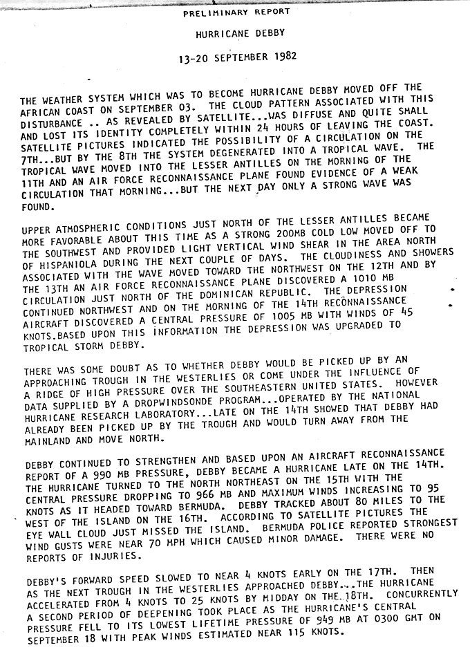
A tropical depression organized into a tropical depression near the northern coast of the Dominican Republic on September13. Initially moving northwestward, the depression turned north and strengthened into Tropical Storm Debby on September 14, before becoming a hurricane early the next day. Debby moved north-northeastward, passing just east of Bermuda. Debby continued strengthening as it moved north, peaking as a Category4 hurricane with winds of 130mph (210km/h) and a minimum pressure of 950mbar (28inHg).[36] The storm weakened significantly before passing to the southeast of Newfoundland on September18, by which time Debby was a Category2. The storm accelerated and weakened to a tropical storm on September20 over the colder waters of the north Atlantic.[37] Debby became extratropical over the far north Atlantic about 365mi (585km) west of Ireland and merged with a strong non-tropical system which was developing over British Isles later that day.[38]
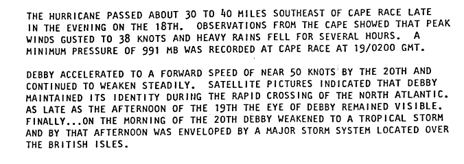
The precursor disturbance to Debby dropped heavy rainfall across Puerto Rico, peaking at 12.86in (327mm) in the southwestern portion of the island.[39] Consequently, some rivers and streams overflowed and landslides occurred, while floodwaters entered some businesses and homes in Guayanilla. One person died after the car he was a passenger accidentally drove into an overflowing stream.[40] Wind gusts on Bermuda approached 70mph (110km/h), leaving minor damage.[36] Debby had little effect on Atlantic Canada, outside of heavy rainfall. Tropical storm-force winds were also recorded at Cape Race.[41] A storm development related to Debby left two dead in Finland.[38]
Tropical Depression Six
Tropical depression(SSHWS)
Duration
September 16– September 20
Peak intensity
35mph (55km/h) (1-min);
This tropical depression formed 900mi (1,450km) west of the Cape Verde Islands on September16,[42] after a low-level circulation developed in association with an area of disturbed weather.[43] Due to intense wind shear, the NHC did not initially anticipate strengthening as the depression moved west-northwestward across the Atlantic.[43][44] The system moved within 750mi (1,205km) east of the Leeward Islands before dissipating on September 20.[45]
The remnant area of disturbed weather from Tropical Depression Six continued moving west-northwest into the southwest north Atlantic. A tropical depression formed from this area 275mi (445km) west of Bermuda on September 25.[46] The system recurved off the north and northeast, dissipating in north Atlantic shipping lanes southeast of Nova Scotia on September 27.[47][48]
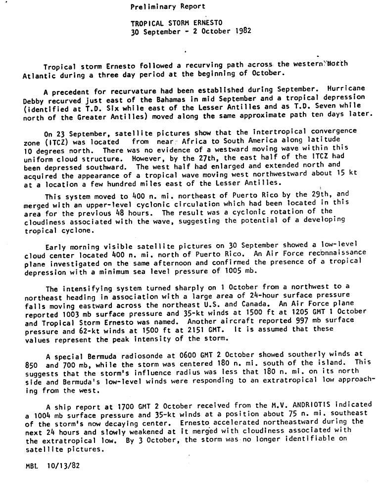
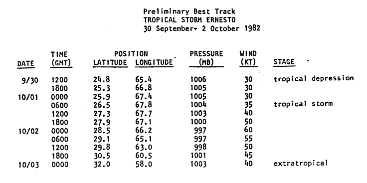
A tropical wave emerged into the Atlantic from the west coast of Africa on September23.[49] The west side of the wave expanded and was designated Tropical Depression Eight on September30 approximately 440mi (710km) north of Puerto Rico.[49][50] The depression intensified and curved sharply northeastward on October1. A reconnaissance flight found 40mph (65km/h) winds with a pressure of 1,003mbar (29.62inHg) and the depression was given the name Ernesto. A second reconnaissance flight on October1 recorded sustained winds of 71mph (114km/h) with a pressure of 997mbar (29.44inHg).[49] However, on October2, Ernesto rapidly weakened and by the next day, the cyclone became unidentifiable after merging with an extratropical low about 390mi (630km) east of Bermuda.[49][50]
The following list of names was used for storms that formed in the North Atlantic in 1982.[51] Each name used this season was utilized for the first time, except for the name Debby as it has previously been used on the old naming lists, but spelled as Debbie. No names were retired from this list following the season,[52] thus it was used again for the 1988 season.[53]
This is a table of all of the storms that formed in the 1982 Atlantic hurricane season. It includes their name, duration, peak classification, and intensities, areas affected, damage, and death totals. Deaths in parentheses are additional and indirect (an example of an indirect death would be a traffic accident), but were still related to that storm. Damage and deaths include totals while the storm was extratropical, a wave, or a low, and all of the damage figures are in 1982 USD.
12EM-DAT: the International Disaster Database (2007). "Disaster List for Cuba". Centre for Research on the Epidemiology of Disasters. Archived from the original on May 13, 2007. Retrieved March 8, 2007.
↑David M. Roth (2009). "Rainfall from Subtropical Storm One". College Park, Maryland: Hydrometeorological Prediction Center. Retrieved November 25, 2025.
↑National Hurricane Operations Plan(PDF) (Report). Washington, D.C.: NOAA Office of the Federal Coordinator for Meteorological Services and Supporting Research. May 1982. p.3-7. Retrieved January 17, 2024.
↑National Hurricane Operations Plan(PDF) (Report). Washington, D.C.: NOAA Office of the Federal Coordinator for Meteorological Services and Supporting Research. May 1988. p.3-7. Retrieved January 17, 2024.
This page is based on this Wikipedia article Text is available under the CC BY-SA 4.0 license; additional terms may apply. Images, videos and audio are available under their respective licenses.


