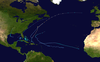
1982 Florida subtropical storm

Last updated

Map key
  Tropical depression (≤38 mph, ≤62 km/h)
  Tropical storm (39–73 mph, 63–118 km/h)
  Category 1 (74–95 mph, 119–153 km/h)
  Category 2 (96–110 mph, 154–177 km/h)
  Category 3 (111–129 mph, 178–208 km/h)
  Category 4 (130–156 mph, 209–251 km/h)
  Category 5 (≥157 mph, ≥252 km/h)
  Unknown
Storm type
Disc Plain black.svg Tropical cyclone
Solid black.svg Subtropical cyclone
ArrowUp.svg Extratropical cyclone, remnant low, tropical disturbance, or monsoon depression

The subtropical storm had an unusual origin by forming from an interaction of two different systems near the Yucatán Peninsula. This occurrence is unusual, but not unique, as Subtropical Storm One in the 1974 season formed in similar pattern. [1] A reconnaissance flight on June 17 reported that there appeared to be multiple transient circulations at the surface, but no well-defined center. [2] The first disturbance can be traced back to June 15 in the northwest Caribbean. The disturbance moved north, along with a low-pressure area that formed over the Yucatán Peninsula. A trough merged with the low-pressure area creating an even stronger trough over the eastern Gulf of Mexico. Conditions in the Gulf of Mexico were favorable for tropical storm formation. Some severe weather had been occurring over the Florida Peninsula as early as June 16, as the fringes of disturbance moved across the Florida Straits and over the Peninsula. [2]

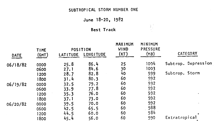
A circulation began to form on June 18 in the eastern Gulf of Mexico, prompting gale warnings. [3] It was declared Subtropical Depression One the same day. The depression made landfall on the morning of June 18 just north of Spring Hill, Florida and gained subtropical storm status over land. The storm was classified as Subtropical Storm One by the National Hurricane Center, as the rule was not to name subtropical storms. The subtropical storm moved to the northeast and crossed the Outer Banks of North Carolina on June 19. Even though the minimum central pressures remained low, the circulation expanded and became distorted. The subtropical storm peaked at 70 mph winds (110 km/h) on June 18, but did not reach its minimum pressure until June 20, when it dropped to 984  mbar (29.07  inHg). [4] The subtropical storm was declared an extratropical storm near the Canadian Maritimes, on the same day. [5] [6]

Preparations

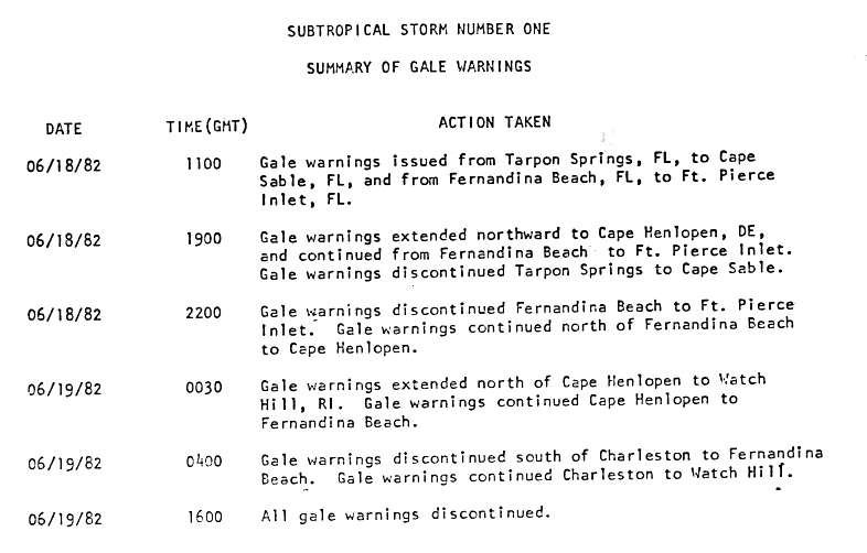
Several warnings were issued in association with the subtropical storm. [7] On June 16, severe thunderstorm watches and warnings were issued for Florida. The next day, more warnings were issued, including tornado, small craft, and special marine warnings. There were also various types of special weather statements issued for heavy rains. Five gale warnings were issued on June 18 and June 19 for the cities on the western coast of Florida. All warnings were discontinued by 12 p.m. EDT (1600 UTC) June 19. The same day, a gale warning was issued from Cape Henlopen, Delaware to Watch Hill, Rhode Island. [7]

The subtropical storm postponed the bi-annual Newport, Rhode Island to Bermuda sailboat race for two consecutive days due to the forecast one of the storm. Subsequent reports from sailboats said that with the track of the storm, if not for the delay, there would have been a marine disaster. [7]

Impact

In its main inflow band over Cuba, rainfall amounts up to 28.66 inches (728 mm) were recorded. [8]

Rainfall Totals for Subtropical Storm One Subtropical Storm One 1982 rainfall.gif
Rainfall Totals for Subtropical Storm One

Most of the storm's effects were felt in Florida where it made landfall on the morning of June 18, causing gales, heavy rains, flooding, beach erosion and tornadoes. [9] The highest winds were recorded at 41 miles per hour (66 km/h) and up to 48 miles per hour (77 km/h) during a thunderstorm at Macdill Air Force Base in Tampa on June 18. Rainfall peaked at 10.72 inches (272.28 mm) in Desoto City, while much of the rest of the state reported between 15 inches (25125 inches) of precipitation. [10] [11] High tides and waves caused flooding and beach erosion from Naples to the Tampa Bay area. Some waterfront buildings suffered damage from undermining including widespread damage of marinas and some boats. Several bulkheads and rock revetments experienced minor damage in Naples and Marco Island. Several man‑made dune structures seaward of the Coastal Construction Control Line in Collier County received minor damage at Vanderbilt Beach and Marco Island. [12] Three people were killed in Florida in association with the subtropical storm with a further thirteen people injured. A Brevard County woman died when a canoe overturned and an Orange County child was killed when he was swept into a drainage ditch. 130 families were evacuated a few days after the storm from the Arcadia River area because the Peace River crested above flood stage. [3]

The subtropical storm spawned twelve tornadoes across Florida, including at least 2 tornadoes which reached a magnitude of F2 on the Fujita Scale. The first tornado formed in Hendry County on June 18 at 0115 UTC reaching F2 strength. [13] The third fatality was a man from Hendry County who was killed in his mobile home, which was destroyed by a tornado. A total of twenty-five homes in Florida were destroyed. Total damage in Florida totaled out to $10 million (1982 USD, $21 million 2007 USD). [3]

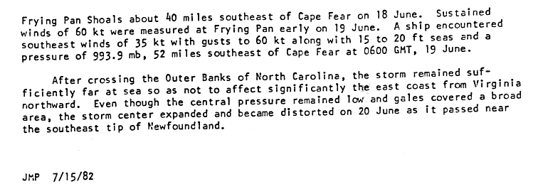
The storm's effects north of Florida were minor. Rainfall reached up to nine inches (228 mm) in extreme eastern South Carolina and four inches (101 mm) in eastern North Carolina. Winds reached 50 miles per hour (80 km/h) with gusts up to 66 miles per hour (106 km/h) at the Oak Island Coast Guard Station near Cape Fear, North Carolina and 54 miles per hour (87 km/h) with gusts of 77 miles per hour (124 km/h) at the offshore tower at Frying Pan Shoals about forty miles southeast of Cape Fear on June 18 with 70 mph winds (110 km/h) the next day. A 68-foot fishing trawler sunk off the coast of Cape Fear in North Carolina from the high waves; no one was killed as the sailors were rescued by the United States Coast Guard on June 19. Flooding was reported with tides of two to three feet in the Carolinas. [3] Rainfall from the subtropical storm reached both states, reaching maximum peaks of up to five inches (127 mm) on the Georgia coast and seven inches on the Georgia/South Carolina border. Rainfall totaled to about one inch (25 mm) on the Virginian coast. [11] A ship encountered winds of a minimum tropical storm with gusts as high as a maximum tropical storm. The ship also encountered a tidal surge of 15 to 20 feet. [3] [10]

See also

Related Research Articles

<span class="mw-page-title-main">Tropical Storm Allison</span> Atlantic tropical storm in 2001

Tropical Storm Allison was a tropical storm that devastated southeast Texas in June of the 2001 Atlantic hurricane season. An arguable example of the "brown ocean effect", Allison lasted unusually long for a June storm, remaining tropical or subtropical for 16 days, most of which was when the storm was over land dumping torrential rainfall. The storm developed from a tropical wave in the northern Gulf of Mexico on June 4, 2001, and struck the upper Texas coast shortly thereafter. It drifted northward through the state, turned back to the south, and re-entered the Gulf of Mexico. The storm continued to the east-northeast, made landfall on Louisiana, then moved across the southeast United States and Mid-Atlantic. Allison was the first storm since Tropical Storm Frances in 1998 to strike the northern Texas coastline.

<span class="mw-page-title-main">1992 Atlantic hurricane season</span>

The 1992 Atlantic hurricane season was a significantly below average season for overall tropical or subtropical cyclones as only ten formed. Six of them became named tropical storms, and four of those became hurricanes; one hurricane became a major hurricane. The season was also near-average in terms of accumulated cyclone energy. The season officially started on June 1 and officially ended on November 30. However, tropical cyclogenesis is possible at any time of the year, as demonstrated by formation in April of an unnamed subtropical storm in the central Atlantic.

<span class="mw-page-title-main">1981 Atlantic hurricane season</span>

The 1981 Atlantic hurricane season featured direct or indirect impacts from nearly all of its 12 tropical or subtropical storms. Overall, the season was fairly active, with 22 tropical depressions, 12 of which became a namable storm, while 7 of those reached hurricane status and 3 intensified into major hurricanes. The season officially began on June 1, 1981, and lasted until November 30, 1981. These dates conventionally delimit the period of each year when most tropical cyclones form in the Atlantic basin. However, tropical cyclogenesis can occur before these dates, as demonstrated with the development of two tropical depressions in April and Tropical Storm Arlene in May. At least one tropical cyclone formed in each month between April and November, with the final system, Subtropical Storm Three, becoming extratropical on November 17, 1981.

<span class="mw-page-title-main">1982 Atlantic hurricane season</span>

The 1982 Atlantic hurricane season was an extremely inactive Atlantic hurricane season with five named tropical storms and one subtropical storm. Two storms became hurricanes, one of which reached major hurricane status. The season officially began on June 1, 1982, and lasted until November 30, 1982. These dates conventionally delimit the period of each year when most tropical cyclones form in the Atlantic basin. Activity started early with Hurricane Alberto forming on the first day of the season. Alberto threatened the Southwestern Florida coast as a tropical storm, meadering offshore in the southeastern Gulf of Mexico and causing 23 fatalities in Cuba. The next system, a subtropical storm, formed later in June and affected the same area as Alberto, causing $10 million in damage.

<span class="mw-page-title-main">Hurricane Danny (1997)</span> Category 1 Atlantic hurricane

Hurricane Danny was the only hurricane to make landfall in the United States during the 1997 Atlantic hurricane season, and the second hurricane and fourth tropical storm of the season. The system became the earliest-formed fifth tropical or subtropical storm of the Atlantic season in history when it attained tropical storm strength on July 17, and held that record until the 2005 Atlantic hurricane season when Tropical Storm Emily broke that record by several days. Like the previous four tropical or subtropical cyclones of the season, Danny had a non-tropical origin, after a trough spawned convection that entered the warm waters of the Gulf of Mexico. Danny was guided northeast through the Gulf of Mexico by two high pressure areas, a rare occurrence in the middle of July. After making landfall on the Gulf Coast, Danny tracked across the southeastern United States and ultimately affected parts of New England with rain and wind.

<span class="mw-page-title-main">Hurricane Charley (1986)</span> Category 1 Atlantic hurricane

Hurricane Charley was the second hurricane to threaten the East Coast of the United States within a year's timeframe, after Hurricane Gloria of 1985. The third tropical storm and second hurricane of the season, Charley formed as a subtropical low on August 13 along the Florida panhandle. After moving off the coast of South Carolina, the system transitioned into a tropical cyclone and intensified into a tropical storm on August 15. Charley later attained hurricane status before moving across eastern North Carolina. It gradually weakened over the north Atlantic Ocean before transitioning into an extratropical cyclone on August 20. Charley's remnants remained identifiable for over a week, until after crossing Ireland and Great Britain they dissipated on August 30.

<span class="mw-page-title-main">Tropical Storm Jerry (1995)</span> Atlantic tropical storm in 1995

Tropical Storm Jerry was a tropical storm that caused severe flooding throughout the southeast United States in August of the 1995 Atlantic hurricane season. Jerry, the tenth tropical storm of the season, formed from a tropical wave that moved off the African coast in early August, which organized into a tropical depression and tropical storm between the Bahamas and Florida later in the month, before striking Florida in the latter part of the month. Its remnant circulation persisted until five days after landfall. The rainfall it produced, amounting to over 12 inches (300 mm) in several locations across Florida, Georgia, and South Carolina, was responsible for $40 million (2005 USD) in damage and 6 deaths. At the time, Jerry was the earliest tenth storm to form in a season on record, until Jose in the 2005 season overtook it. Tropical Storm Jerry was also the first tropical cyclone to make landfall in South Florida since Hurricane Andrew in 1992.

<span class="mw-page-title-main">Tropical Storm Bill (2003)</span> Atlantic tropical cyclone

Tropical Storm Bill was a tropical storm that affected the Gulf Coast of the United States in the summer of 2003. The second storm of the 2003 Atlantic hurricane season, Bill developed from a tropical wave on June 29 to the north of the Yucatán Peninsula. It slowly organized as it moved northward, and reached a peak of 60 miles per hour (97 km/h) shortly before making landfall in south-central Louisiana. Bill quickly weakened over land, and as it accelerated to the northeast, moisture from the storm, combined with cold air from an approaching cold front, produced an outbreak of 34 tornadoes. Bill became extratropical on July 2, and was absorbed by the cold front later that day.

<span class="mw-page-title-main">Tropical Storm Chris (1988)</span> Atlantic tropical storm in 1988

Tropical Storm Chris caused minor flooding in the Greater Antilles and the Eastern United States in August 1988. The seventh tropical cyclone and third named storm of the annual hurricane season, Chris developed from a tropical wave while roughly midway between Africa and the Lesser Antilles on August 21. Forming as a tropical depression, it remained weak for several days, crossing the Lesser Antilles, Hispaniola, and The Bahamas during this time. While offshore the coast of Florida on August 28, the depression intensified into Tropical Storm Chris. Thereafter, the system tracked rapidly north-northwestward and came ashore near Savannah, Georgia later that day. Once inland, Chris quickly weakened, and by early on the following day, it weakened to a tropical depression over South Carolina. Six hours later, Chris was absorbed by a cold front while over North Carolina, though the remnants of the system tracked across the Eastern United States and Atlantic Canada before dissipating on August 30.

<span class="mw-page-title-main">Hurricane Bob (1985)</span> Category 1 Atlantic hurricane

Hurricane Bob was the first of six hurricanes to strike the United States during the 1985 Atlantic hurricane season. The second tropical storm and first hurricane of the year, Bob developed from a tropical wave on July 21 in the eastern Gulf of Mexico. Bob began moving east, making landfall southwestern Florida as a weak tropical storm. The storm then turned to the north and quickly intensified to hurricane status on July 24. The next day, it made landfall near Beaufort, South Carolina, becoming one of a record-tying six hurricanes to hit the United States during a single season. Bob quickly weakened over land, and was absorbed by a frontal trough over eastern West Virginia on July 26.

<span class="mw-page-title-main">Hurricane Abby (1968)</span> Category 1 Atlantic hurricane in 1968

Hurricane Abby made landfall in Cuba, Florida, and North Carolina in June 1968. The first tropical cyclone, first named storm, and first hurricane on the season, Abby developed over the northwestern Caribbean Sea on June 1, as a result of the interaction between a mid-tropospheric trough and a cold front. Moving generally north-northeastward, the depression slowly strengthened while approaching the western tip of Cuba, becoming Tropical Storm Abby late on June 2. Shortly thereafter, Abby made landfall in Pinar del Río Province. The storm dropped heavy rainfall in western Cuba, with up to 12 inches (300 mm) on Isla de la Juventud. However, no flooding was reported. After reaching the southeastern Gulf of Mexico on June 3, Abby strengthened further and became a Category 1 hurricane on the modern-day Saffir–Simpson hurricane wind scale. However, early on June 4, Abby weakened to a tropical storm. Around midday on June 4, the system made landfall near Punta Gorda, Florida as a strong tropical storm.

<span class="mw-page-title-main">Tropical Storm Marco (1990)</span> Atlantic tropical storm

Tropical Storm Marco was the only tropical cyclone to make landfall on the United States during the 1990 Atlantic hurricane season. The 13th named storm of the season, Marco formed from a cold-core low pressure area along the northern coast of Cuba on October 9, and tracked northwestward through the eastern Gulf of Mexico. With most of its circulation over the western portion of Florida, Tropical Storm Marco produced 65 mph (105 km/h) winds over land. However, it weakened to a tropical depression before moving ashore near Cedar Key. The cyclone combined with a cold front and the remnants of Hurricane Klaus to produce heavy rainfall in Georgia and the Carolinas. After interacting with the nearby Hurricane Lili, Marco continued northward until being absorbed by a cold front on October 13.

<span class="mw-page-title-main">Hurricane Alberto (1982)</span> Category 1 Atlantic hurricane in 1982

Hurricane Alberto was a Category 1 hurricane that caused the worst flooding in western Cuba in 32 years. The first tropical storm and hurricane of the 1982 Atlantic hurricane season, Alberto developed from a tropical disturbance on June 2 in the southern Gulf of Mexico. It rapidly organized and attained hurricane status the following day, the earliest date for a hurricane in the Atlantic Ocean since Hurricane Alma in May 1970. Shortly after reaching peak winds off 85 mph (137 km/h), Alberto rapidly weakened due to approaching upper-level winds. Initial forecasts predicted the hurricane would continue northeastward into Florida; it turned sharply westward and drifted erratically for several days across the eastern Gulf of Mexico, before dissipating on June 6.

<span class="mw-page-title-main">Hurricane Florence (1988)</span> Category 1 Atlantic hurricane in 1988

Hurricane Florence was the third of four named tropical cyclones to make landfall on the United States during the 1988 Atlantic hurricane season. The seventh tropical storm and second hurricane of the season, Florence developed on September 7 from an area of convection associated with a dissipating frontal trough in the southern Gulf of Mexico. After initially moving eastward, the storm turned northward and strengthened. Florence reached hurricane status and later peak winds of 80 mph (130 km/h) on September 9 shortly before striking southeastern Louisiana. The storm rapidly weakened over land and dissipated on September 11 over northeastern Texas.

<span class="mw-page-title-main">Tropical Storm Chris (1982)</span> Atlantic tropical storm in 1982

Tropical Storm Chris caused minor flooding along the Gulf Coast of the United States in September 1982. The fifth tropical or subtropical cyclone and third named storm of the 1982 Atlantic hurricane season, Chris developed from a surface low-pressure area in the northern Gulf of Mexico on September 9. Although initially displaying subtropical characteristics, the low pressure area gradually acquired tropical characteristics, and was reclassified as Tropical Depression Four within 24 hours of development. The depression then began to intensify and was upgraded to Tropical Storm Chris on September 10. Thereafter, the storm turned north-north-eastward and strengthened further. On September 11, Chris peaked as a 65 mph (100 km/h) tropical storm. Later that day, it made landfall near Sabine Pass, Port Arthur, Texas. By September 13, Chris dissipated over Arkansas.

<span class="mw-page-title-main">Hurricane Babe</span> Category 1 Atlantic hurricane in 1977

Hurricane Babe was the second named storm and the first to impact the United States during the inactive 1977 Atlantic hurricane season. Forming out of a tropical wave on September 3, Babe began as a subtropical cyclone in the eastern Gulf of Mexico. The storm gradually intensified as it tracked westward. On September 5, the storm turned north and acquired tropical characteristics. Later that day, Babe intensified into a hurricane and attained its peak strength with winds of 75 mph (120 km/h) and a barometric pressure of 995 mbar. Several hours later, the hurricane made landfall in Louisiana and quickly weakened. By September 6, Babe had weakened to a tropical depression and later dissipated early on September 9 over North Carolina.

<span class="mw-page-title-main">Tropical Storm Bret (1981)</span> Atlantic tropical storm in 1981

Tropical Storm Bret was a strong tropical storm that made a rare landfall on the Delmarva Peninsula in June 1981. The sixth tropical cyclone, third designated tropical depression, and second named storm of the season, Bret developed as a subtropical storm from a large area of frontal clouds near Bermuda on June 29. Moving westward, the subtropical storm intensified while producing deep convection, and was consequently reclassified as a tropical storm early on June 30. Around that time, Bret peaked with sustained winds of 70 mph (110 km/h). The storm then began weakening and struck near Oyster, Virginia as a minimal tropical storm early on July 1. Upon moving inland, Bret weakened to a tropical depression and subsequently accelerated prior to dissipating over northern Virginia that same day.

References

  1. Paul Herbert (1974). "Subtropical Storm One (1974) Preliminary Report". National Hurricane Center. Retrieved 2007-03-28.
  2. 1 2 Joseph M. Pelissier (1982-07-15). "Subtropical Storm One (1982) Preliminary Report - Section I - Storm History I". National Hurricane Center. Retrieved 2007-04-05.
  3. 1 2 3 4 5 Joseph M. Pelissier (1982-07-15). "Subtropical Storm One (1982) Preliminary Report - Section 2 - Storm History II + Impact". National Hurricane Center. Retrieved 2007-04-05.
  4. Joseph M. Pelissier (1982-07-15). "Subtropical Storm One (1982) Preliminary Report - Section 7 - Meteorological stats chart". National Hurricane Center. Retrieved 2007-12-08.
  5. Canadian Hurricane Centre (1982-07-15). "Canadian Hurricane Center Report". Canadian Hurricane Center. Archived from the original on 2006-05-13. Retrieved 2007-03-28.
  6. Joseph M. Pelissier (1982-07-15). "Subtropical Storm One (1982) Preliminary Report - Section 3 - Storm History + Impact II". National Hurricane Center. Retrieved 2007-12-16.
  7. 1 2 3 Joseph M. Pelissier (1982-07-15). "Subtropical Storm One (1982) Preliminary Report - Section 4 - Warnings/Watches". National Hurricane Center. Retrieved 2007-04-05.
  8. Instituto Nacional de Recursos Hidráulicos (2003). "Lluvias intensas observadas y grandes inundaciones reportadas" (in Spanish). Archived from the original on 12 March 2007. Retrieved 2007-02-10.
  9. Florida Department of Environmental Protection (2003). "Strategic Beach Management Plan" (PDF). Archived from the original (PDF) on 2011-06-09. Retrieved 2007-12-17.
  10. 1 2 Gilbert B. Clark (1982). "1982 Monthly Weather Review" (PDF). American Meteorological Society. Retrieved 2007-03-28.
  11. 1 2 David Roth (2006). "Rainfall Totals: Subtropical Storm One (1982)". Hydrometeorological Prediction Center. Retrieved 2007-03-28.
  12. Collier County, Florida (2007). "Collier County Flood History". Collier County, Florida. Retrieved 2007-03-28.[ permanent dead link ]
  13. Tom Grazulis of The Tornado Project and Bill McCaul of USRA Huntsville (2007). "List of Known Tropical Cyclones Which Have Spawned Tornadoes". Tornado Project. Retrieved 2007-03-28.
Subtropical Storm One
STS 1 1982 Jun 18 1942Z.jpg
Subtropical Storm One traveling up the Eastern Seaboard on June 18